SlideShare a Scribd company logo
1 of 1
Download to read offline
DSM Extraction from Pleiades Images Using RSP
Muhammad Irsyadi Firdaus, Jiann-Yeou Rau
Department of Geomatics, National Cheng Kung University, Taiwan
Introduction
The Pleiades constellation is a high-resolution satellite imagery (HRSI).
The great agility of the Pleiades satellites with their motion capabilities in a
roll, pitch, and yaw enables the system to maximize the number of
acquisitions over a certain area and provide stereos along the paths that can
obtain tri-stereo or quadri-stereo images. The purpose of this study is to
assess and measure the capacity of the Pleiades system to generate the
Digital Surface Model (DSM) using RPC Stereo Processor (RSP). RSP is a
software package for digital surface model and true-orthophoto generation
from satellite stereo imagery. In this study, DSM was produced using three
Pleiades stereo images in Taipei city. To evaluate the quality of DSM from
HRSI, we compare it with DSM generated from aerialphoto. The
comparable objects are buildings, roads, and sports fields.
Result
Conclusion
Reference
Figure 1. DSM from aerialphoto
Figure 3. DSM HRSI – DSM AP
Figure 2. DSM from Pleiades
Figure 4. True Orthophoto from
3D Model
Workflow
This paper has introduced an operational-ready software package named
RSP (RPC stereo processor) that produces DSM and true-orthophoto
from RPC-modelled stereo imagery. RSP is highly optimized and can
compute large-frame image very efficiently. In this study, the highest
DSM value difference between HRSI and Aerialphoto is on the objects
road 1, road 2 and road 3. Over the city areas, image matching was
susceptible to difficulties associated with low image contrast and
shadowing, resulting in decreased accuracy.
Qin, Rongjun. 2016. RPC Stereo Processor (RSP) – A Software Package
For Digital Surface Model And Orthophoto Generation From
Satellite Stereo Imagery. ISPRS Annals of the Photogrammetry,
Remote Sensing and Spatial Information Sciences, Volume III-1.
Qin, R., A. Gruen and C. Fraser, 2014. Quality Assessment of Image
Matchers for DSM Generation - A Comparative Study Based on
UAV Images. In: Asian Conference on Remote Sensing, Nay Pyi
Taw, Myanmar, 27-31, Octomber, 2014, pp.
DSM AP Building 1 DSM HRSI Building 1
DSM AP Road 2 DSM HRSI Road 2
Figure 9. Graphic Difference DSM HRSI - DSM AP
In order to take into account the influence of topographic variation on the
modelled surface, the DSM strip area was divided into separate sub-areas
representing different land covers. These comprised urban areas, with a
further subdivision into regions within these three categories. DSM HRSI-AP
Building 1
DSM HRSI-AP
Road 2
-20
-15
-10
-5
0
5
10
15
20
Building 1 Building 2 Building 3 Building 4 Building 5 Road 1 Road 2 Road 3 Sports 1 Sports 2
Difference DSM HRSI – DSM AP
Difference DSM HRSI - DSM AP Min Difference DSM HRSI - DSM AP Max
Difference DSM HRSI - DSM AP Mean Difference DSM HRSI - DSM AP StdDev
In Fig. 9, the urban area has three categories incorporated the building class
including tall buildings; sporting fields (Sporting fields class)
encompassing flat tennis courts and basketball court; and roadway (road
class) encompassing crossroads.
The results are summarized in Fig. 9 and show that, in general, accuracy
degrades in road class. Categories that have low accuracy differences
are buildings and sports.
Fig. 6. Building 1 APFig. 5. Building 1 HRSI
Fig. 8. Road 1 APFig. 7. Road 1 HRSI
brightness and contrast while in figure 6 is building obtained from
aerialphoto which has higher brightness and contrast.
The image difference
between figure 5 and
6 is in brightness and
contrast images.
Figure 5 is building
1 obtained from
HRSI which has low
shadows when compared with image 8 which has no shadow and a higher
contrast image. This will affect the image matching and accuracy of DSM.
For the road
category, in figure 7
and figure 8 is a
road 1 image that
has a very clear
distinction. Figure 7
has low contrast,
RPC Stereo Pair
DSM and True-Orthophoto
Image Correction
Bundle adjustment
Dense Image Matching
DSM and True-Orthophoto
DSM Overlay
Analysis
RSP
Tie-point Matching
Bundle adjustment
Dense Image Matching
Aerial Images

More Related Content

What's hot

Ortho photo in Ottawa
Ortho photo in OttawaOrtho photo in Ottawa
Ortho photo in OttawaStephen
 
TYBSC IT PGIS Unit V Data Visualization
TYBSC IT PGIS Unit V  Data VisualizationTYBSC IT PGIS Unit V  Data Visualization
TYBSC IT PGIS Unit V Data VisualizationArti Parab Academics
 
Sem 8 major presentation
Sem 8 major presentationSem 8 major presentation
Sem 8 major presentationVaibhav Bajpai
 
International Journal of Engineering and Science Invention (IJESI)
International Journal of Engineering and Science Invention (IJESI)International Journal of Engineering and Science Invention (IJESI)
International Journal of Engineering and Science Invention (IJESI)inventionjournals
 
Digital terrain representations(last)
Digital terrain representations(last)Digital terrain representations(last)
Digital terrain representations(last)Muhammad1212
 
Maplat - Historical viewer technology that guarantees nonlinear bijective con...
Maplat - Historical viewer technology that guarantees nonlinear bijective con...Maplat - Historical viewer technology that guarantees nonlinear bijective con...
Maplat - Historical viewer technology that guarantees nonlinear bijective con...Kohei Otsuka
 
IEEE VTC Chicago 1995
IEEE VTC Chicago 1995IEEE VTC Chicago 1995
IEEE VTC Chicago 1995Said Khomri
 
OpenStreetMap - The Quality Issue
OpenStreetMap - The Quality IssueOpenStreetMap - The Quality Issue
OpenStreetMap - The Quality IssueCASA, UCL
 
Express Maps Presentation - Innovative Mapping Service Online
Express Maps Presentation - Innovative Mapping Service OnlineExpress Maps Presentation - Innovative Mapping Service Online
Express Maps Presentation - Innovative Mapping Service OnlineSpot Image
 
Maplat - Historical map viewer technology that guarantees nonlinear bijective...
Maplat - Historical map viewer technology that guarantees nonlinear bijective...Maplat - Historical map viewer technology that guarantees nonlinear bijective...
Maplat - Historical map viewer technology that guarantees nonlinear bijective...Kohei Otsuka
 
Examples for leverage points
Examples for leverage pointsExamples for leverage points
Examples for leverage pointsGeorges Grinstein
 
Meshing and Simplification of High Resolution Urban Surface Data for UAV Path...
Meshing and Simplification of High Resolution Urban Surface Data for UAV Path...Meshing and Simplification of High Resolution Urban Surface Data for UAV Path...
Meshing and Simplification of High Resolution Urban Surface Data for UAV Path...Florian-Michael Adolf
 
2018 11-10 From Printed Map to Live Navigation
2018 11-10 From Printed Map to Live Navigation2018 11-10 From Printed Map to Live Navigation
2018 11-10 From Printed Map to Live NavigationBruno Coudoin
 
Cartographic symbology. By proj jasper
Cartographic symbology. By proj jasperCartographic symbology. By proj jasper
Cartographic symbology. By proj jasperAgbajiJacob
 
The importance of map
The importance of mapThe importance of map
The importance of maparceyes
 

What's hot (20)

Digital terrain model
Digital terrain modelDigital terrain model
Digital terrain model
 
Ortho photo in Ottawa
Ortho photo in OttawaOrtho photo in Ottawa
Ortho photo in Ottawa
 
DTM DEM Generation
DTM DEM GenerationDTM DEM Generation
DTM DEM Generation
 
TYBSC IT PGIS Unit V Data Visualization
TYBSC IT PGIS Unit V  Data VisualizationTYBSC IT PGIS Unit V  Data Visualization
TYBSC IT PGIS Unit V Data Visualization
 
Sem 8 major presentation
Sem 8 major presentationSem 8 major presentation
Sem 8 major presentation
 
RouteForYou
RouteForYouRouteForYou
RouteForYou
 
International Journal of Engineering and Science Invention (IJESI)
International Journal of Engineering and Science Invention (IJESI)International Journal of Engineering and Science Invention (IJESI)
International Journal of Engineering and Science Invention (IJESI)
 
Types of-maps - part 2
Types of-maps - part 2Types of-maps - part 2
Types of-maps - part 2
 
Digital terrain representations(last)
Digital terrain representations(last)Digital terrain representations(last)
Digital terrain representations(last)
 
Maplat - Historical viewer technology that guarantees nonlinear bijective con...
Maplat - Historical viewer technology that guarantees nonlinear bijective con...Maplat - Historical viewer technology that guarantees nonlinear bijective con...
Maplat - Historical viewer technology that guarantees nonlinear bijective con...
 
IEEE VTC Chicago 1995
IEEE VTC Chicago 1995IEEE VTC Chicago 1995
IEEE VTC Chicago 1995
 
OpenStreetMap - The Quality Issue
OpenStreetMap - The Quality IssueOpenStreetMap - The Quality Issue
OpenStreetMap - The Quality Issue
 
Express Maps Presentation - Innovative Mapping Service Online
Express Maps Presentation - Innovative Mapping Service OnlineExpress Maps Presentation - Innovative Mapping Service Online
Express Maps Presentation - Innovative Mapping Service Online
 
Maplat - Historical map viewer technology that guarantees nonlinear bijective...
Maplat - Historical map viewer technology that guarantees nonlinear bijective...Maplat - Historical map viewer technology that guarantees nonlinear bijective...
Maplat - Historical map viewer technology that guarantees nonlinear bijective...
 
Examples for leverage points
Examples for leverage pointsExamples for leverage points
Examples for leverage points
 
Meshing and Simplification of High Resolution Urban Surface Data for UAV Path...
Meshing and Simplification of High Resolution Urban Surface Data for UAV Path...Meshing and Simplification of High Resolution Urban Surface Data for UAV Path...
Meshing and Simplification of High Resolution Urban Surface Data for UAV Path...
 
2018 11-10 From Printed Map to Live Navigation
2018 11-10 From Printed Map to Live Navigation2018 11-10 From Printed Map to Live Navigation
2018 11-10 From Printed Map to Live Navigation
 
Cartographic symbology. By proj jasper
Cartographic symbology. By proj jasperCartographic symbology. By proj jasper
Cartographic symbology. By proj jasper
 
The importance of map
The importance of mapThe importance of map
The importance of map
 
Maps and GIS
Maps and GISMaps and GIS
Maps and GIS
 

Similar to DSM Extraction from Pleiades Images Using RSP

LocalizationandMappingforAutonomousNavigationin OutdoorTerrains: A StereoVisi...
LocalizationandMappingforAutonomousNavigationin OutdoorTerrains: A StereoVisi...LocalizationandMappingforAutonomousNavigationin OutdoorTerrains: A StereoVisi...
LocalizationandMappingforAutonomousNavigationin OutdoorTerrains: A StereoVisi...Minh Quan Nguyen
 
3D Gaussian Splatting
3D Gaussian Splatting3D Gaussian Splatting
3D Gaussian Splattingtaeseon ryu
 
Detection of Bridges using Different Types of High Resolution Satellite Images
Detection of Bridges using Different Types of High Resolution Satellite ImagesDetection of Bridges using Different Types of High Resolution Satellite Images
Detection of Bridges using Different Types of High Resolution Satellite Imagesidescitation
 
TRAFFIC-SIGN RECOGNITION FOR AN INTELLIGENT VEHICLE/DRIVER ASSISTANT SYSTEM U...
TRAFFIC-SIGN RECOGNITION FOR AN INTELLIGENT VEHICLE/DRIVER ASSISTANT SYSTEM U...TRAFFIC-SIGN RECOGNITION FOR AN INTELLIGENT VEHICLE/DRIVER ASSISTANT SYSTEM U...
TRAFFIC-SIGN RECOGNITION FOR AN INTELLIGENT VEHICLE/DRIVER ASSISTANT SYSTEM U...cseij
 
C documents and settings_administrator_local settings_application data_mozil...
C  documents and settings_administrator_local settings_application data_mozil...C  documents and settings_administrator_local settings_application data_mozil...
C documents and settings_administrator_local settings_application data_mozil...Anuar Ahmad
 
Parcel-based Damage Detection using SAR Data
Parcel-based Damage Detection using SAR DataParcel-based Damage Detection using SAR Data
Parcel-based Damage Detection using SAR DataReza Nourjou, Ph.D.
 
APPLYING R-SPATIOGRAM IN OBJECT TRACKING FOR OCCLUSION HANDLING
APPLYING R-SPATIOGRAM IN OBJECT TRACKING FOR OCCLUSION HANDLINGAPPLYING R-SPATIOGRAM IN OBJECT TRACKING FOR OCCLUSION HANDLING
APPLYING R-SPATIOGRAM IN OBJECT TRACKING FOR OCCLUSION HANDLINGsipij
 
A novel fast block matching algorithm considering cost function and stereo al...
A novel fast block matching algorithm considering cost function and stereo al...A novel fast block matching algorithm considering cost function and stereo al...
A novel fast block matching algorithm considering cost function and stereo al...IAEME Publication
 
An index based road feature extraction from LANDSAT-8 OLI images
An index based road feature extraction from LANDSAT-8 OLI imagesAn index based road feature extraction from LANDSAT-8 OLI images
An index based road feature extraction from LANDSAT-8 OLI imagesIJECEIAES
 
Article rilem 2012_ino_mtq_pavemetrics
Article rilem 2012_ino_mtq_pavemetricsArticle rilem 2012_ino_mtq_pavemetrics
Article rilem 2012_ino_mtq_pavemetricsRichard Fox-Ivey
 
MAP MAKING FROM TABLES
MAP MAKING FROM TABLESMAP MAKING FROM TABLES
MAP MAKING FROM TABLESijcga
 
MAP MAKING FROM TABLES
MAP MAKING FROM TABLESMAP MAKING FROM TABLES
MAP MAKING FROM TABLESijcga
 
An Assessment of Image Matching Algorithms in Depth Estimation
An Assessment of Image Matching Algorithms in Depth EstimationAn Assessment of Image Matching Algorithms in Depth Estimation
An Assessment of Image Matching Algorithms in Depth EstimationCSCJournals
 
Scattered gis handbook
Scattered gis handbookScattered gis handbook
Scattered gis handbookWaleed Liaqat
 
isvc_draft6_final_1_harvey_mudd (1)
isvc_draft6_final_1_harvey_mudd (1)isvc_draft6_final_1_harvey_mudd (1)
isvc_draft6_final_1_harvey_mudd (1)David Tenorio
 
Leader Follower Formation Control of Ground Vehicles Using Dynamic Pixel Coun...
Leader Follower Formation Control of Ground Vehicles Using Dynamic Pixel Coun...Leader Follower Formation Control of Ground Vehicles Using Dynamic Pixel Coun...
Leader Follower Formation Control of Ground Vehicles Using Dynamic Pixel Coun...ijma
 

Similar to DSM Extraction from Pleiades Images Using RSP (20)

LocalizationandMappingforAutonomousNavigationin OutdoorTerrains: A StereoVisi...
LocalizationandMappingforAutonomousNavigationin OutdoorTerrains: A StereoVisi...LocalizationandMappingforAutonomousNavigationin OutdoorTerrains: A StereoVisi...
LocalizationandMappingforAutonomousNavigationin OutdoorTerrains: A StereoVisi...
 
3D Gaussian Splatting
3D Gaussian Splatting3D Gaussian Splatting
3D Gaussian Splatting
 
cvpr10-depth
cvpr10-depthcvpr10-depth
cvpr10-depth
 
Detection of Bridges using Different Types of High Resolution Satellite Images
Detection of Bridges using Different Types of High Resolution Satellite ImagesDetection of Bridges using Different Types of High Resolution Satellite Images
Detection of Bridges using Different Types of High Resolution Satellite Images
 
TRAFFIC-SIGN RECOGNITION FOR AN INTELLIGENT VEHICLE/DRIVER ASSISTANT SYSTEM U...
TRAFFIC-SIGN RECOGNITION FOR AN INTELLIGENT VEHICLE/DRIVER ASSISTANT SYSTEM U...TRAFFIC-SIGN RECOGNITION FOR AN INTELLIGENT VEHICLE/DRIVER ASSISTANT SYSTEM U...
TRAFFIC-SIGN RECOGNITION FOR AN INTELLIGENT VEHICLE/DRIVER ASSISTANT SYSTEM U...
 
C documents and settings_administrator_local settings_application data_mozil...
C  documents and settings_administrator_local settings_application data_mozil...C  documents and settings_administrator_local settings_application data_mozil...
C documents and settings_administrator_local settings_application data_mozil...
 
Dtm Quality Assesment
Dtm Quality AssesmentDtm Quality Assesment
Dtm Quality Assesment
 
Parcel-based Damage Detection using SAR Data
Parcel-based Damage Detection using SAR DataParcel-based Damage Detection using SAR Data
Parcel-based Damage Detection using SAR Data
 
Photogrammetry
PhotogrammetryPhotogrammetry
Photogrammetry
 
APPLYING R-SPATIOGRAM IN OBJECT TRACKING FOR OCCLUSION HANDLING
APPLYING R-SPATIOGRAM IN OBJECT TRACKING FOR OCCLUSION HANDLINGAPPLYING R-SPATIOGRAM IN OBJECT TRACKING FOR OCCLUSION HANDLING
APPLYING R-SPATIOGRAM IN OBJECT TRACKING FOR OCCLUSION HANDLING
 
A novel fast block matching algorithm considering cost function and stereo al...
A novel fast block matching algorithm considering cost function and stereo al...A novel fast block matching algorithm considering cost function and stereo al...
A novel fast block matching algorithm considering cost function and stereo al...
 
A novel fast block matching algorithm considering cost function and stereo al...
A novel fast block matching algorithm considering cost function and stereo al...A novel fast block matching algorithm considering cost function and stereo al...
A novel fast block matching algorithm considering cost function and stereo al...
 
An index based road feature extraction from LANDSAT-8 OLI images
An index based road feature extraction from LANDSAT-8 OLI imagesAn index based road feature extraction from LANDSAT-8 OLI images
An index based road feature extraction from LANDSAT-8 OLI images
 
Article rilem 2012_ino_mtq_pavemetrics
Article rilem 2012_ino_mtq_pavemetricsArticle rilem 2012_ino_mtq_pavemetrics
Article rilem 2012_ino_mtq_pavemetrics
 
MAP MAKING FROM TABLES
MAP MAKING FROM TABLESMAP MAKING FROM TABLES
MAP MAKING FROM TABLES
 
MAP MAKING FROM TABLES
MAP MAKING FROM TABLESMAP MAKING FROM TABLES
MAP MAKING FROM TABLES
 
An Assessment of Image Matching Algorithms in Depth Estimation
An Assessment of Image Matching Algorithms in Depth EstimationAn Assessment of Image Matching Algorithms in Depth Estimation
An Assessment of Image Matching Algorithms in Depth Estimation
 
Scattered gis handbook
Scattered gis handbookScattered gis handbook
Scattered gis handbook
 
isvc_draft6_final_1_harvey_mudd (1)
isvc_draft6_final_1_harvey_mudd (1)isvc_draft6_final_1_harvey_mudd (1)
isvc_draft6_final_1_harvey_mudd (1)
 
Leader Follower Formation Control of Ground Vehicles Using Dynamic Pixel Coun...
Leader Follower Formation Control of Ground Vehicles Using Dynamic Pixel Coun...Leader Follower Formation Control of Ground Vehicles Using Dynamic Pixel Coun...
Leader Follower Formation Control of Ground Vehicles Using Dynamic Pixel Coun...
 

More from National Cheng Kung University

Accuracy assessment and 3D Mapping by Consumer Grade Spherical Camera
Accuracy assessment and 3D Mapping by Consumer Grade Spherical CameraAccuracy assessment and 3D Mapping by Consumer Grade Spherical Camera
Accuracy assessment and 3D Mapping by Consumer Grade Spherical CameraNational Cheng Kung University
 
3D Rekonstruksi Bangunan Menggunakan Gambar Panorama Sebagai Upaya Untuk Miti...
3D Rekonstruksi Bangunan Menggunakan Gambar Panorama Sebagai Upaya Untuk Miti...3D Rekonstruksi Bangunan Menggunakan Gambar Panorama Sebagai Upaya Untuk Miti...
3D Rekonstruksi Bangunan Menggunakan Gambar Panorama Sebagai Upaya Untuk Miti...National Cheng Kung University
 
3D Indoor and Outdoor Mapping from Point Cloud Generated by Spherical Camera
3D Indoor and Outdoor Mapping from Point Cloud Generated by Spherical Camera3D Indoor and Outdoor Mapping from Point Cloud Generated by Spherical Camera
3D Indoor and Outdoor Mapping from Point Cloud Generated by Spherical CameraNational Cheng Kung University
 
Satellite Image Classification using Decision Tree, SVM and k-Nearest Neighbor
Satellite Image Classification using Decision Tree, SVM and k-Nearest NeighborSatellite Image Classification using Decision Tree, SVM and k-Nearest Neighbor
Satellite Image Classification using Decision Tree, SVM and k-Nearest NeighborNational Cheng Kung University
 
Optimal Filtering with Kalman Filters and Smoothers Using AndroSensor IMU Data
Optimal Filtering with Kalman Filters and Smoothers Using AndroSensor IMU DataOptimal Filtering with Kalman Filters and Smoothers Using AndroSensor IMU Data
Optimal Filtering with Kalman Filters and Smoothers Using AndroSensor IMU DataNational Cheng Kung University
 
Satellite Image Classification using Decision Tree, SVM and k-Nearest Neighbor
Satellite Image Classification using Decision Tree, SVM and k-Nearest NeighborSatellite Image Classification using Decision Tree, SVM and k-Nearest Neighbor
Satellite Image Classification using Decision Tree, SVM and k-Nearest NeighborNational Cheng Kung University
 
A Method of Mining Association Rules for Geographical Points of Interest
A Method of Mining Association Rules for Geographical Points of InterestA Method of Mining Association Rules for Geographical Points of Interest
A Method of Mining Association Rules for Geographical Points of InterestNational Cheng Kung University
 
Building classification model, tree model, confusion matrix and prediction ac...
Building classification model, tree model, confusion matrix and prediction ac...Building classification model, tree model, confusion matrix and prediction ac...
Building classification model, tree model, confusion matrix and prediction ac...National Cheng Kung University
 
Accuracy Analysis of Three-Dimensional Model Reconstructed by Spherical Video...
Accuracy Analysis of Three-Dimensional Model Reconstructed by Spherical Video...Accuracy Analysis of Three-Dimensional Model Reconstructed by Spherical Video...
Accuracy Analysis of Three-Dimensional Model Reconstructed by Spherical Video...National Cheng Kung University
 
Association Rule (Data Mining) - Frequent Itemset Generation, Closed Frequent...
Association Rule (Data Mining) - Frequent Itemset Generation, Closed Frequent...Association Rule (Data Mining) - Frequent Itemset Generation, Closed Frequent...
Association Rule (Data Mining) - Frequent Itemset Generation, Closed Frequent...National Cheng Kung University
 
The rotation matrix (DCM) and quaternion in Inertial Survey and Navigation Sy...
The rotation matrix (DCM) and quaternion in Inertial Survey and Navigation Sy...The rotation matrix (DCM) and quaternion in Inertial Survey and Navigation Sy...
The rotation matrix (DCM) and quaternion in Inertial Survey and Navigation Sy...National Cheng Kung University
 
SIFT/SURF can achieve scale, rotation and illumination invariant during image...
SIFT/SURF can achieve scale, rotation and illumination invariant during image...SIFT/SURF can achieve scale, rotation and illumination invariant during image...
SIFT/SURF can achieve scale, rotation and illumination invariant during image...National Cheng Kung University
 
3D reconstruction by photogrammetry and 4D deformation measurement
3D reconstruction by photogrammetry and 4D deformation measurement3D reconstruction by photogrammetry and 4D deformation measurement
3D reconstruction by photogrammetry and 4D deformation measurementNational Cheng Kung University
 

More from National Cheng Kung University (20)

Accuracy assessment and 3D Mapping by Consumer Grade Spherical Camera
Accuracy assessment and 3D Mapping by Consumer Grade Spherical CameraAccuracy assessment and 3D Mapping by Consumer Grade Spherical Camera
Accuracy assessment and 3D Mapping by Consumer Grade Spherical Camera
 
3D Rekonstruksi Bangunan Menggunakan Gambar Panorama Sebagai Upaya Untuk Miti...
3D Rekonstruksi Bangunan Menggunakan Gambar Panorama Sebagai Upaya Untuk Miti...3D Rekonstruksi Bangunan Menggunakan Gambar Panorama Sebagai Upaya Untuk Miti...
3D Rekonstruksi Bangunan Menggunakan Gambar Panorama Sebagai Upaya Untuk Miti...
 
3D Rekonstruksi Bangunan Menggunakan Gambar Panorama Sebagai Upaya Untuk Miti...
3D Rekonstruksi Bangunan Menggunakan Gambar Panorama Sebagai Upaya Untuk Miti...3D Rekonstruksi Bangunan Menggunakan Gambar Panorama Sebagai Upaya Untuk Miti...
3D Rekonstruksi Bangunan Menggunakan Gambar Panorama Sebagai Upaya Untuk Miti...
 
3D Indoor and Outdoor Mapping from Point Cloud Generated by Spherical Camera
3D Indoor and Outdoor Mapping from Point Cloud Generated by Spherical Camera3D Indoor and Outdoor Mapping from Point Cloud Generated by Spherical Camera
3D Indoor and Outdoor Mapping from Point Cloud Generated by Spherical Camera
 
3D Indoor and Outdoor Mapping from Point Cloud Generated by Spherical Camera
3D Indoor and Outdoor Mapping from Point Cloud Generated by Spherical Camera3D Indoor and Outdoor Mapping from Point Cloud Generated by Spherical Camera
3D Indoor and Outdoor Mapping from Point Cloud Generated by Spherical Camera
 
Handbook PPI Tainan Taiwan 2018
Handbook PPI Tainan Taiwan 2018Handbook PPI Tainan Taiwan 2018
Handbook PPI Tainan Taiwan 2018
 
Satellite Image Classification using Decision Tree, SVM and k-Nearest Neighbor
Satellite Image Classification using Decision Tree, SVM and k-Nearest NeighborSatellite Image Classification using Decision Tree, SVM and k-Nearest Neighbor
Satellite Image Classification using Decision Tree, SVM and k-Nearest Neighbor
 
Optimal Filtering with Kalman Filters and Smoothers Using AndroSensor IMU Data
Optimal Filtering with Kalman Filters and Smoothers Using AndroSensor IMU DataOptimal Filtering with Kalman Filters and Smoothers Using AndroSensor IMU Data
Optimal Filtering with Kalman Filters and Smoothers Using AndroSensor IMU Data
 
Satellite Image Classification using Decision Tree, SVM and k-Nearest Neighbor
Satellite Image Classification using Decision Tree, SVM and k-Nearest NeighborSatellite Image Classification using Decision Tree, SVM and k-Nearest Neighbor
Satellite Image Classification using Decision Tree, SVM and k-Nearest Neighbor
 
EKF and RTS smoother toolbox
EKF and RTS smoother toolboxEKF and RTS smoother toolbox
EKF and RTS smoother toolbox
 
Kalman Filter Basic
Kalman Filter BasicKalman Filter Basic
Kalman Filter Basic
 
A Method of Mining Association Rules for Geographical Points of Interest
A Method of Mining Association Rules for Geographical Points of InterestA Method of Mining Association Rules for Geographical Points of Interest
A Method of Mining Association Rules for Geographical Points of Interest
 
Calibration of Inertial Sensor within Smartphone
Calibration of Inertial Sensor within SmartphoneCalibration of Inertial Sensor within Smartphone
Calibration of Inertial Sensor within Smartphone
 
Pengukuran GPS Menggunakan Trimble Secara Manual
Pengukuran GPS Menggunakan Trimble Secara ManualPengukuran GPS Menggunakan Trimble Secara Manual
Pengukuran GPS Menggunakan Trimble Secara Manual
 
Building classification model, tree model, confusion matrix and prediction ac...
Building classification model, tree model, confusion matrix and prediction ac...Building classification model, tree model, confusion matrix and prediction ac...
Building classification model, tree model, confusion matrix and prediction ac...
 
Accuracy Analysis of Three-Dimensional Model Reconstructed by Spherical Video...
Accuracy Analysis of Three-Dimensional Model Reconstructed by Spherical Video...Accuracy Analysis of Three-Dimensional Model Reconstructed by Spherical Video...
Accuracy Analysis of Three-Dimensional Model Reconstructed by Spherical Video...
 
Association Rule (Data Mining) - Frequent Itemset Generation, Closed Frequent...
Association Rule (Data Mining) - Frequent Itemset Generation, Closed Frequent...Association Rule (Data Mining) - Frequent Itemset Generation, Closed Frequent...
Association Rule (Data Mining) - Frequent Itemset Generation, Closed Frequent...
 
The rotation matrix (DCM) and quaternion in Inertial Survey and Navigation Sy...
The rotation matrix (DCM) and quaternion in Inertial Survey and Navigation Sy...The rotation matrix (DCM) and quaternion in Inertial Survey and Navigation Sy...
The rotation matrix (DCM) and quaternion in Inertial Survey and Navigation Sy...
 
SIFT/SURF can achieve scale, rotation and illumination invariant during image...
SIFT/SURF can achieve scale, rotation and illumination invariant during image...SIFT/SURF can achieve scale, rotation and illumination invariant during image...
SIFT/SURF can achieve scale, rotation and illumination invariant during image...
 
3D reconstruction by photogrammetry and 4D deformation measurement
3D reconstruction by photogrammetry and 4D deformation measurement3D reconstruction by photogrammetry and 4D deformation measurement
3D reconstruction by photogrammetry and 4D deformation measurement
 

Recently uploaded

Research Methodolgy & Intellectual Property Rights Series 2
Research Methodolgy & Intellectual Property Rights Series 2Research Methodolgy & Intellectual Property Rights Series 2
Research Methodolgy & Intellectual Property Rights Series 2T.D. Shashikala
 
Software Engineering - Modelling Concepts + Class Modelling + Building the An...
Software Engineering - Modelling Concepts + Class Modelling + Building the An...Software Engineering - Modelling Concepts + Class Modelling + Building the An...
Software Engineering - Modelling Concepts + Class Modelling + Building the An...Prakhyath Rai
 
Complex plane, Modulus, Argument, Graphical representation of a complex numbe...
Complex plane, Modulus, Argument, Graphical representation of a complex numbe...Complex plane, Modulus, Argument, Graphical representation of a complex numbe...
Complex plane, Modulus, Argument, Graphical representation of a complex numbe...MohammadAliNayeem
 
Artificial Intelligence Bayesian Reasoning
Artificial Intelligence Bayesian ReasoningArtificial Intelligence Bayesian Reasoning
Artificial Intelligence Bayesian Reasoninghotman30312
 
Theory for How to calculation capacitor bank
Theory for How to calculation capacitor bankTheory for How to calculation capacitor bank
Theory for How to calculation capacitor banktawat puangthong
 
ROAD CONSTRUCTION PRESENTATION.PPTX.pptx
ROAD CONSTRUCTION PRESENTATION.PPTX.pptxROAD CONSTRUCTION PRESENTATION.PPTX.pptx
ROAD CONSTRUCTION PRESENTATION.PPTX.pptxGagandeepKaur617299
 
Multivibrator and its types defination and usges.pptx
Multivibrator and its types defination and usges.pptxMultivibrator and its types defination and usges.pptx
Multivibrator and its types defination and usges.pptxalijaker017
 
RM&IPR M5 notes.pdfResearch Methodolgy & Intellectual Property Rights Series 5
RM&IPR M5 notes.pdfResearch Methodolgy & Intellectual Property Rights Series 5RM&IPR M5 notes.pdfResearch Methodolgy & Intellectual Property Rights Series 5
RM&IPR M5 notes.pdfResearch Methodolgy & Intellectual Property Rights Series 5T.D. Shashikala
 
Quiz application system project report..pdf
Quiz application system project report..pdfQuiz application system project report..pdf
Quiz application system project report..pdfKamal Acharya
 
Interfacing Analog to Digital Data Converters ee3404.pdf
Interfacing Analog to Digital Data Converters ee3404.pdfInterfacing Analog to Digital Data Converters ee3404.pdf
Interfacing Analog to Digital Data Converters ee3404.pdfragupathi90
 
Diploma Engineering Drawing Qp-2024 Ece .pdf
Diploma Engineering Drawing Qp-2024 Ece .pdfDiploma Engineering Drawing Qp-2024 Ece .pdf
Diploma Engineering Drawing Qp-2024 Ece .pdfJNTUA
 
Instruct Nirmaana 24-Smart and Lean Construction Through Technology.pdf
Instruct Nirmaana 24-Smart and Lean Construction Through Technology.pdfInstruct Nirmaana 24-Smart and Lean Construction Through Technology.pdf
Instruct Nirmaana 24-Smart and Lean Construction Through Technology.pdfEr.Sonali Nasikkar
 
Lab Manual Arduino UNO Microcontrollar.docx
Lab Manual Arduino UNO Microcontrollar.docxLab Manual Arduino UNO Microcontrollar.docx
Lab Manual Arduino UNO Microcontrollar.docxRashidFaridChishti
 
Introduction to Artificial Intelligence and History of AI
Introduction to Artificial Intelligence and History of AIIntroduction to Artificial Intelligence and History of AI
Introduction to Artificial Intelligence and History of AISheetal Jain
 
Electrostatic field in a coaxial transmission line
Electrostatic field in a coaxial transmission lineElectrostatic field in a coaxial transmission line
Electrostatic field in a coaxial transmission lineJulioCesarSalazarHer1
 
Research Methodolgy & Intellectual Property Rights Series 1
Research Methodolgy & Intellectual Property Rights Series 1Research Methodolgy & Intellectual Property Rights Series 1
Research Methodolgy & Intellectual Property Rights Series 1T.D. Shashikala
 
Fabrication Of Automatic Star Delta Starter Using Relay And GSM Module By Utk...
Fabrication Of Automatic Star Delta Starter Using Relay And GSM Module By Utk...Fabrication Of Automatic Star Delta Starter Using Relay And GSM Module By Utk...
Fabrication Of Automatic Star Delta Starter Using Relay And GSM Module By Utk...ShivamTiwari995432
 
ChatGPT Prompt Engineering for project managers.pdf
ChatGPT Prompt Engineering for project managers.pdfChatGPT Prompt Engineering for project managers.pdf
ChatGPT Prompt Engineering for project managers.pdfqasastareekh
 
Seismic Hazard Assessment Software in Python by Prof. Dr. Costas Sachpazis
Seismic Hazard Assessment Software in Python by Prof. Dr. Costas SachpazisSeismic Hazard Assessment Software in Python by Prof. Dr. Costas Sachpazis
Seismic Hazard Assessment Software in Python by Prof. Dr. Costas SachpazisDr.Costas Sachpazis
 
15-Minute City: A Completely New Horizon
15-Minute City: A Completely New Horizon15-Minute City: A Completely New Horizon
15-Minute City: A Completely New HorizonMorshed Ahmed Rahath
 

Recently uploaded (20)

Research Methodolgy & Intellectual Property Rights Series 2
Research Methodolgy & Intellectual Property Rights Series 2Research Methodolgy & Intellectual Property Rights Series 2
Research Methodolgy & Intellectual Property Rights Series 2
 
Software Engineering - Modelling Concepts + Class Modelling + Building the An...
Software Engineering - Modelling Concepts + Class Modelling + Building the An...Software Engineering - Modelling Concepts + Class Modelling + Building the An...
Software Engineering - Modelling Concepts + Class Modelling + Building the An...
 
Complex plane, Modulus, Argument, Graphical representation of a complex numbe...
Complex plane, Modulus, Argument, Graphical representation of a complex numbe...Complex plane, Modulus, Argument, Graphical representation of a complex numbe...
Complex plane, Modulus, Argument, Graphical representation of a complex numbe...
 
Artificial Intelligence Bayesian Reasoning
Artificial Intelligence Bayesian ReasoningArtificial Intelligence Bayesian Reasoning
Artificial Intelligence Bayesian Reasoning
 
Theory for How to calculation capacitor bank
Theory for How to calculation capacitor bankTheory for How to calculation capacitor bank
Theory for How to calculation capacitor bank
 
ROAD CONSTRUCTION PRESENTATION.PPTX.pptx
ROAD CONSTRUCTION PRESENTATION.PPTX.pptxROAD CONSTRUCTION PRESENTATION.PPTX.pptx
ROAD CONSTRUCTION PRESENTATION.PPTX.pptx
 
Multivibrator and its types defination and usges.pptx
Multivibrator and its types defination and usges.pptxMultivibrator and its types defination and usges.pptx
Multivibrator and its types defination and usges.pptx
 
RM&IPR M5 notes.pdfResearch Methodolgy & Intellectual Property Rights Series 5
RM&IPR M5 notes.pdfResearch Methodolgy & Intellectual Property Rights Series 5RM&IPR M5 notes.pdfResearch Methodolgy & Intellectual Property Rights Series 5
RM&IPR M5 notes.pdfResearch Methodolgy & Intellectual Property Rights Series 5
 
Quiz application system project report..pdf
Quiz application system project report..pdfQuiz application system project report..pdf
Quiz application system project report..pdf
 
Interfacing Analog to Digital Data Converters ee3404.pdf
Interfacing Analog to Digital Data Converters ee3404.pdfInterfacing Analog to Digital Data Converters ee3404.pdf
Interfacing Analog to Digital Data Converters ee3404.pdf
 
Diploma Engineering Drawing Qp-2024 Ece .pdf
Diploma Engineering Drawing Qp-2024 Ece .pdfDiploma Engineering Drawing Qp-2024 Ece .pdf
Diploma Engineering Drawing Qp-2024 Ece .pdf
 
Instruct Nirmaana 24-Smart and Lean Construction Through Technology.pdf
Instruct Nirmaana 24-Smart and Lean Construction Through Technology.pdfInstruct Nirmaana 24-Smart and Lean Construction Through Technology.pdf
Instruct Nirmaana 24-Smart and Lean Construction Through Technology.pdf
 
Lab Manual Arduino UNO Microcontrollar.docx
Lab Manual Arduino UNO Microcontrollar.docxLab Manual Arduino UNO Microcontrollar.docx
Lab Manual Arduino UNO Microcontrollar.docx
 
Introduction to Artificial Intelligence and History of AI
Introduction to Artificial Intelligence and History of AIIntroduction to Artificial Intelligence and History of AI
Introduction to Artificial Intelligence and History of AI
 
Electrostatic field in a coaxial transmission line
Electrostatic field in a coaxial transmission lineElectrostatic field in a coaxial transmission line
Electrostatic field in a coaxial transmission line
 
Research Methodolgy & Intellectual Property Rights Series 1
Research Methodolgy & Intellectual Property Rights Series 1Research Methodolgy & Intellectual Property Rights Series 1
Research Methodolgy & Intellectual Property Rights Series 1
 
Fabrication Of Automatic Star Delta Starter Using Relay And GSM Module By Utk...
Fabrication Of Automatic Star Delta Starter Using Relay And GSM Module By Utk...Fabrication Of Automatic Star Delta Starter Using Relay And GSM Module By Utk...
Fabrication Of Automatic Star Delta Starter Using Relay And GSM Module By Utk...
 
ChatGPT Prompt Engineering for project managers.pdf
ChatGPT Prompt Engineering for project managers.pdfChatGPT Prompt Engineering for project managers.pdf
ChatGPT Prompt Engineering for project managers.pdf
 
Seismic Hazard Assessment Software in Python by Prof. Dr. Costas Sachpazis
Seismic Hazard Assessment Software in Python by Prof. Dr. Costas SachpazisSeismic Hazard Assessment Software in Python by Prof. Dr. Costas Sachpazis
Seismic Hazard Assessment Software in Python by Prof. Dr. Costas Sachpazis
 
15-Minute City: A Completely New Horizon
15-Minute City: A Completely New Horizon15-Minute City: A Completely New Horizon
15-Minute City: A Completely New Horizon
 

DSM Extraction from Pleiades Images Using RSP

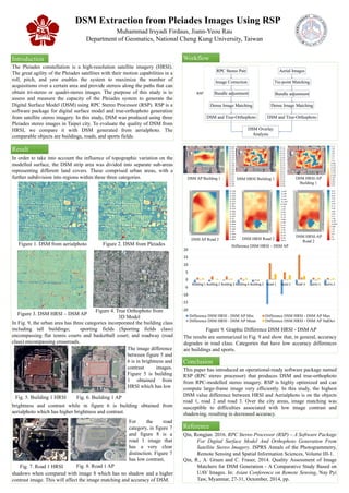
  • 1. DSM Extraction from Pleiades Images Using RSP Muhammad Irsyadi Firdaus, Jiann-Yeou Rau Department of Geomatics, National Cheng Kung University, Taiwan Introduction The Pleiades constellation is a high-resolution satellite imagery (HRSI). The great agility of the Pleiades satellites with their motion capabilities in a roll, pitch, and yaw enables the system to maximize the number of acquisitions over a certain area and provide stereos along the paths that can obtain tri-stereo or quadri-stereo images. The purpose of this study is to assess and measure the capacity of the Pleiades system to generate the Digital Surface Model (DSM) using RPC Stereo Processor (RSP). RSP is a software package for digital surface model and true-orthophoto generation from satellite stereo imagery. In this study, DSM was produced using three Pleiades stereo images in Taipei city. To evaluate the quality of DSM from HRSI, we compare it with DSM generated from aerialphoto. The comparable objects are buildings, roads, and sports fields. Result Conclusion Reference Figure 1. DSM from aerialphoto Figure 3. DSM HRSI – DSM AP Figure 2. DSM from Pleiades Figure 4. True Orthophoto from 3D Model Workflow This paper has introduced an operational-ready software package named RSP (RPC stereo processor) that produces DSM and true-orthophoto from RPC-modelled stereo imagery. RSP is highly optimized and can compute large-frame image very efficiently. In this study, the highest DSM value difference between HRSI and Aerialphoto is on the objects road 1, road 2 and road 3. Over the city areas, image matching was susceptible to difficulties associated with low image contrast and shadowing, resulting in decreased accuracy. Qin, Rongjun. 2016. RPC Stereo Processor (RSP) – A Software Package For Digital Surface Model And Orthophoto Generation From Satellite Stereo Imagery. ISPRS Annals of the Photogrammetry, Remote Sensing and Spatial Information Sciences, Volume III-1. Qin, R., A. Gruen and C. Fraser, 2014. Quality Assessment of Image Matchers for DSM Generation - A Comparative Study Based on UAV Images. In: Asian Conference on Remote Sensing, Nay Pyi Taw, Myanmar, 27-31, Octomber, 2014, pp. DSM AP Building 1 DSM HRSI Building 1 DSM AP Road 2 DSM HRSI Road 2 Figure 9. Graphic Difference DSM HRSI - DSM AP In order to take into account the influence of topographic variation on the modelled surface, the DSM strip area was divided into separate sub-areas representing different land covers. These comprised urban areas, with a further subdivision into regions within these three categories. DSM HRSI-AP Building 1 DSM HRSI-AP Road 2 -20 -15 -10 -5 0 5 10 15 20 Building 1 Building 2 Building 3 Building 4 Building 5 Road 1 Road 2 Road 3 Sports 1 Sports 2 Difference DSM HRSI – DSM AP Difference DSM HRSI - DSM AP Min Difference DSM HRSI - DSM AP Max Difference DSM HRSI - DSM AP Mean Difference DSM HRSI - DSM AP StdDev In Fig. 9, the urban area has three categories incorporated the building class including tall buildings; sporting fields (Sporting fields class) encompassing flat tennis courts and basketball court; and roadway (road class) encompassing crossroads. The results are summarized in Fig. 9 and show that, in general, accuracy degrades in road class. Categories that have low accuracy differences are buildings and sports. Fig. 6. Building 1 APFig. 5. Building 1 HRSI Fig. 8. Road 1 APFig. 7. Road 1 HRSI brightness and contrast while in figure 6 is building obtained from aerialphoto which has higher brightness and contrast. The image difference between figure 5 and 6 is in brightness and contrast images. Figure 5 is building 1 obtained from HRSI which has low shadows when compared with image 8 which has no shadow and a higher contrast image. This will affect the image matching and accuracy of DSM. For the road category, in figure 7 and figure 8 is a road 1 image that has a very clear distinction. Figure 7 has low contrast, RPC Stereo Pair DSM and True-Orthophoto Image Correction Bundle adjustment Dense Image Matching DSM and True-Orthophoto DSM Overlay Analysis RSP Tie-point Matching Bundle adjustment Dense Image Matching Aerial Images