This document summarizes a study on Cenozoic geomorphological and paleo-environmental evolution in China using multi-source data. Key findings include:
1) Seven river terraces were identified along the Huangshui River using remote sensing images, DEM data, and field surveys.
2) Three planation surfaces and 11 denudation surfaces were mapped in the Minhe area based on DEM analysis and interpretation of remote sensing and field data.
3) Color synthetic images and analyses of water content helped distinguish Cretaceous, Tertiary, and loess strata, clarifying the geological structure.
![Cenozoic geomorphological and paleo- environmental evolution survey
using multi-source data conformity
Yunhai Zhu*a,b
, Ze Sunc
, Chaoling Lid
, Qingwen Yud
, Kexin Zhanga,b
,
Xiaohu Koua,b
,Wanguo Wange
a
Faculty of Earth Sciences, China University of Geosciences, Wuhan 430074, Hubei,P.R.China;
b
Geological Survey of China University of Geosciences, Wuhan 430074,Hubei,P.R.China;
c
Jilin Normal University, Siping136000,Jilin, P.R.China; d
China Geological Survey Bureau,
Beijing100083, P.R.China; e
Regional Geological Survey Institute of Hubei Province, Wuhan430000,
P.R.China
ABSTRACT
The earth surface information is very important in study of Cenozoic geomorphological evolution and paleo-environment
evolution. In this essay, we adopt remote sensing data, DEM data and finity geological survey data to study the valley
geomorphology. It indicates there are seven river terrace developed in Huangshui river area and saved integrity. we can
recognize high flood plain, T1 terrace, T2 terrace and T3 terrace in remote sensing image. From the study on
geomorphology using Digital elevation model(DEM) , We made the diagram of geomophological geological map based
on three-dimension DEM data in Minhe area , identify three planation surfaces and 11 Denudation surfaces and discuss
the distribution, altitude, uplift speed of different planation surface. We also discuss the method in distinguish Cenozoic
strata with other geological body.
Keywords: multi-source data conformity, Cenozoic, geomorphological evolution, paleo-environmental evolution
1. INTRODUCTION
Cenozoic Geological mapping, especially Quaternary geological mapping which related with human activity, is
relatively weakness in China. During the globle history, Cenozoic is an important geological period tightly related with
human survive and development. Many fatal problems in three main topics on current international society development,
population, resource and environment, are all closely linked with Cenozoic geology. So it is important to study Cenozoic
geology.
Because of complex geological condition, special physical geography and zoology, abundant nature resource and severe
geological disaster, it has become an important area in country resource survey of Western area in china, especially in
Tibet plateau and circumjacent area. In Cenozoic strata area, how to use the digital geological mapping method, adopt
multi technique, utilize multi-source geological data[1]
, study the relation between Cenozoic geomorphological evolution
and paleo-environment evolution has become the technique basement in Quaternary geological survey in Western area.
It is mainly involved the earth surface information on the study of Cenozoic geomorphological evolution and
paleo-environment evolution. Utilizing the multi-source data, we should use remote sensing data, DEM data and finity
geological survey data. We ascertain planation surfaces, terraces according high precision remote sensing data, DEM
data. Combined the former geological and chronology data, we analyze Tibet plateau uplift spread rule in different stages
regionally and then discuss the evolution of Tibet plateau. We take the Minhe and Linxia area as the example to discuss
the Cenozoic geomorphological evolution and paleo-environment evolution.
*yhzhu@cug.edu.cn; phone 86-27-6358 8901
Geoinformatics 2007: Remotely Sensed Data and Information, edited by Weimin Ju, Shuhe Zhao
Proc. of SPIE Vol. 6752, 675220, (2007) · 0277-786X/07/$18 · doi: 10.1117/12.760733
Proc. of SPIE Vol. 6752 675220-1
Downloaded From: http://proceedings.spiedigitallibrary.org/ on 05/31/2013 Terms of Use: http://spiedl.org/terms](https://image.slidesharecdn.com/zhu2007-210629154340/85/Zhu2007-1-320.jpg)
![Digtial Mapping System - [PRBDB (Mci Shan H50E006023)]
F .
1
12. 5±O 3TKeB2
C14 '
I Gps.wt
Ei
I Photo.wt
J Routing.wI
1i Sample.wt
I Sand_s..
J Sand_s...
1i Sectioned
Section.wt
1I Sketch.wt
j Mulwater.wl
1 Mulwater.wt
J Mulsoit.wt
I Mulstrem.wt
EI25WAT...
1I 2SROCK.WL
2SROCK.WT _d
25501L.WL €I
II 25501L.WT
I25STRE...
1125STRE... _d
25WAT...
I
I
I
jI
I
I
C
Ki
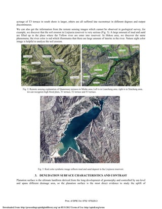
2. TERRACE STUDY
There are Yellow river, Datong river, Huangshui river and Zhuanglang river in Minhe area, and they consist Yellow river
system together in studying area. Among them, Huangshui river and Zhuanglang river is the first branch of Yellow river
system, Datonghe river is the second branch. Terraces are developed well and abroad distributed in studying area,
especially Huangshui river, Yellow river, Datong river and Zhuanglang river. From the field practical measured profile
combined with the remote sensing and DEM data, the study on river valley relief indicates that the terrace in Huangshui
river is developed best and reserved integrallty, it has 7 terraces from T0 to T6 (Fig. 1)
Fig. 1. Digital geological mapping of terraces in Minhe area, Qinghai Province.
Huangshui river is one of the mainly branch of Yellow river, and originated from the west edge of Qilianshan mountains
, and was thought as the upriver riverway of paleo-Yellow river. Terraces are developed badly in gorge area and
developed 5 to 7 inside basin. Most of terraces are bedrock seated terraces, thicker alluvial gravel layer overlay the
bedrock seated, thick loessland overlay on the top. Among the 7 terraces, T0-T3 keep the original terrace plate basically,
T4-T6 terrace surfaces are formed a series of mount and hill due to subsequently erosion, they are all erosive contact
each other.
The Huangshui river is 700 km longer in studying area and influx to Yellow river in Hekou area, Lanzhou city. It
develops two planation surface, seven terraces from T0 to T6 in drainage area, among them T0 to T3 are developed best.
The terraces are revealed clearly in remote sensing image (Fig. 2). We can recognize high flood plain, T1 terrace, T2
terrace and T3 terrace. It is clearer in remote sensing image than field observation because the observation scale.
The development of terraces is not the same in different section and has asymmetry in each side of the river. Right
diagram in Fig. 2 displays the valley terraces of Huangshui river in Xincheng area. The terrace in north shore is better
than south one. Terrace shape is reserved well in north shore, terrace sequence is output continuous basically. Besides the
Proc. of SPIE Vol. 6752 675220-2
Downloaded From: http://proceedings.spiedigitallibrary.org/ on 05/31/2013 Terms of Use: http://spiedl.org/terms](https://image.slidesharecdn.com/zhu2007-210629154340/85/Zhu2007-2-320.jpg)
![I F24UUUm
4000b
Dabanmountains
3500
Hualong
I
I A Datongriver
P 3000m I 1 P 3000m I I III
T JxkY
I /i ArPt1 T-T P1-3 QP1-3 I Ii 01 I I I I 'IT k Ifl
2500
7 FIuangshui nv
1/
/Pt1d
I
V /
I-1ENX FN.X Foothill planation surface 0Y
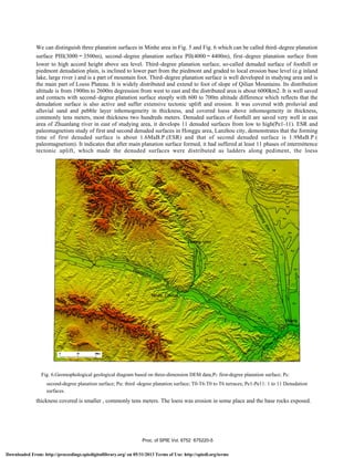
Qinghai-Xizang Tibet and was studied unfailing for many years[2-4]
. Former study considered that there are three
uplifting, two planate in Qinghai-Xizang Tibet,and exist two planation surfaces, namely peak planation surface and
main planation surface. From the field survey, we also make sure that there are two planation surfaces(3000m,4000m)
in studying area (Fig. 4)[5]
and inosculate with the conclusion of two planation surfaces in Qilian Mountains(3000m,
4000m) by Li Jijun (2001)[6]
.
Fig.4. Tectonic and geomophological profile from Laji mountains to Daban mountains
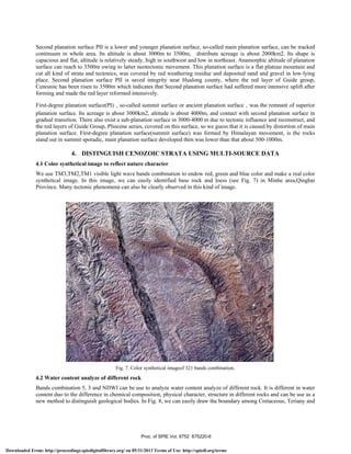
Digital elevation model(DEM) is a very useful tool in Quaternary geomophological studying and can distinguish and
understand planation surface in different elevation directly. We made three-dimension DEM diagram in Minhe
area(Fig.5) and researched the geomophological character. We also interpreted that diagram combined with remote
sensing image and original field geological survey data and get the diagram of geomophological geological map based
on three-dimension DEM data in Minhe area (Fig. 6).
Fig.5. Three-dimension DEM diagram in Minhe area.
Proc. of SPIE Vol. 6752 675220-4
Downloaded From: http://proceedings.spiedigitallibrary.org/ on 05/31/2013 Terms of Use: http://spiedl.org/terms](https://image.slidesharecdn.com/zhu2007-210629154340/85/Zhu2007-4-320.jpg)
![IAPIS - [DSGIAPJ
____________________________________ - x
____ is ?1
- j5J 1362 1370 1387 1400 1412 1425 1437 1450
IL ii
DTERLK8L —
DTRALK.8L
DZGEoLINE.SL :
o 1 25UII.WL
-
D*.8L -
D.SL J
LI J _ALTERATION_PNT.st
Eli _ATTITIJDE. st
—
o j _CRATER. st
OoIt
DRRIW0LE.st -
D_F0SSILst —
LI _ISOTOPE. st .. :
Dispst.st €I :
o _PHOTOGRAP}(. st [J —
DLSAMPLE.st
DLSKETC8.st
D1_sPRING.st
oj ADD_lAYER. ST j —
DANOPT.ST
OAttitds.st
OIATTN0TE.ST
—
o j COLO1JM_SECTION. ST j
o ] CUTTING_PROFILE.ST i :
DFsssi1.st
DFss.st -
s Gss1sbs1. st 9
ULEGEND.ST
U MAP_PRONE. ST j
LI 0TROR1.ST
E1RESPT.ST
DSssp1st 9
DSsstiss.st e
DSkstsh.st
o ______
o lk.st
D.ST
TERLK. UT
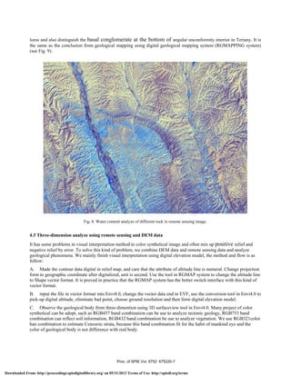
Fig. 9. Geological map made in RGMAP system show the same area of Fig. 8.
Fig. 10 shows the geological body of Qp3pl in plane (left) and three-dimention image. In three-dimention remote image,
we can clearly distinguish this kind of geological body with other geological body.
Fig. 10. Geological body of Qp3pl in plane and three-dimension remote image; left is the plane remote image and
the right one is three-dimension remote sensing image.
Proc. of SPIE Vol. 6752 675220-8
Downloaded From: http://proceedings.spiedigitallibrary.org/ on 05/31/2013 Terms of Use: http://spiedl.org/terms](https://image.slidesharecdn.com/zhu2007-210629154340/85/Zhu2007-8-320.jpg)


![Heritage hetherington lidar_pdf[1]](https://cdn.slidesharecdn.com/ss_thumbnails/heritagehetheringtonlidarpdf1-100701210824-phpapp02-thumbnail.jpg?width=640&height=640&fit=bounds)


