1) The study mapped an area in southern Margaritifer Terra, Mars containing 5 large impact craters to understand the geologic history and role of water.
2) The craters showed evidence of alluvial fans, aeolian deposits, and fluvial erosion indicating water once flowed on the surface. Older fans within Crater 1 suggest the presence of an ancient lake.
3) Overall, the features revealed the area experienced impact cratering, mass wasting, and fluvial erosion and deposition from water in the past like rainfall, snowmelt, or groundwater. Mapping helped decipher the complex geologic processes that shaped the landscape over time.
The surface of Pluto is more geologically diverse and dynamic than had been expected,
but the role of its tenuous atmosphere in shaping the landscape remains unclear. We
describe observations from the New Horizons spacecraft of regularly spaced, linear ridges
whose morphology, distribution, and orientation are consistent with being transverse
dunes. These are located close to mountainous regions and are orthogonal to nearby wind
streaks. We demonstrate that the wavelength of the dunes (~0.4 to 1 kilometer) is best
explained by the deposition of sand-sized (~200 to ~300 micrometer) particles of methane
ice in moderate winds (<10 meters per second). The undisturbed morphology of the dunes,
and relationships with the underlying convective glacial ice, imply that the dunes have
formed in the very recent geological past.
The integration of space born and ground remotely sensed dataoilandgas24
The integration of space born and ground remotely sensed data in exploring the environmental stresses and deterioration in ras gharib area, gulf of suez, egypt
It has been proposed that ~3.4 billion years ago an ocean fed by enormous catastrophic floods covered
most of the Martian northern lowlands. However, a persistent problem with this hypothesis is the
lack of definitive paleoshoreline features. Here, based on geomorphic and thermal image mapping in
the circum-Chryse and northwestern Arabia Terra regions of the northern plains, in combination with
numerical analyses, we show evidence for two enormous tsunami events possibly triggered by bolide
impacts, resulting in craters ~30km in diameter and occurring perhaps a few million years apart. The
tsunamis produced widespread littoral landforms, including run-up water-ice-rich and bouldery lobes,
which extended tens to hundreds of kilometers over gently sloping plains and boundary cratered
highlands, as well as backwash channels where wave retreat occurred on highland-boundary surfaces.
The ice-rich lobes formed in association with the younger tsunami, showing that their emplacement
took place following a transition into a colder global climatic regime that occurred after the older
tsunami event. We conclude that, on early Mars, tsunamis played a major role in generating and
resurfacing coastal terrains.
Geology is the one of the most interesting subject about mother earth which can be best studied on field. This report of geological field work done at Chobhar area, Kathmandu consists observation with analysis regarding geological features, structures and processes.
Geologic time scale, Uniformitarianism, Catastrophic concept, Geomorphic process-agent cause and product, Hutton's concept, Davis Concept, Darwin's concept, Gilbert's concept
Themis: An I/O-Efficient MapReduce (SoCC 2012)Alex Rasmussen
“Big Data” computing increasingly utilizes the MapReduce programming model for scalable processing of large data collections. Many MapReduce jobs are I/O-bound, and so minimizing the number of I/O operations is critical to improving their performance. In this work, we present Themis, a MapReduce implementation that reads and writes data records to disk exactly twice, which is the minimum amount possible for data sets that cannot fit in memory. In order to minimize I/O, Themis makes fundamentally different design decisions from previous MapReduce implementations. Themis performs a wide variety of MapReduce jobs – including click log analysis, DNA read sequence alignment, and PageRank – at nearly the speed of TritonSort’s record-setting sort performance [29].
Geologic processes that shape the planet Earth, which occurs beneath the surface and associated with Interior forces. Download this so you can see some animations and some hidden images behind some pictures.
-Examined features ranging from valley systems in Margaritifer Sinus to inverted topography in Aeolis/Zephyria Plana
-Studied and analyzed MOLA, THEMIS-VIS, OMEGA, MOC, CRISM, HRSC, and CTX imagery
Modern water at low latitudes on Mars: Potential evidence from dune surfacesSérgio Sacani
Landforms on the Martian surface are critical to understanding the nature of surface processes in the recent
past. However, modern hydroclimatic conditions on Mars remain enigmatic, as explanations for the formation
of observed landforms are ambiguous. We report crusts, cracks, aggregates, and bright polygonal ridges on the
surfaces of hydrated salt-rich dunes of southern Utopia Planitia (~25°N) from in situ exploration by the Zhurong
rover. These surface features were inferred to form after 1.4 to 0.4 million years ago. Wind and CO2 frost processes can be ruled out as potential mechanisms. Instead, involvement of saline water from thawed frost/snow is
the most likely cause. This discovery sheds light on more humid conditions of the modern Martian climate and
provides critical clues to future exploration missions searching for signs of extant life, particularly at low latitudes with comparatively warmer, more amenable surface temperatures.
Martian soil as revealed by ground-penetrating radar at the Tianwen-1 landing...Sérgio Sacani
Much of the Martian surface is covered by a weathering layer (regolith or soil) produced
by long-term surface processes such as impact gardening, eolian erosion, water weathering,
and glacial modifications. China’s first Martian mission, Tianwen-1, employed the Mars
Rover Penetrating Radar (RoPeR) to unveil the detailed structure of the regolith layer and
assess its loss tangent. The RoPeR radargram revealed the local regolith layer to be highly
heterogeneous and geologically complex and characterized by structures that resemble partial
or complete crater walls and near-surface impact lenses at a very shallow depth. However,
comparable radar data from the Lunar far side are rather uniform, despite the two surfaces
being geologically contemporary. The close-to-surface crater presented in this study shows
no detectable surface expression, which suggests an accelerated occultation rate for small
craters on the surface of Mars as compared to the rate on the Moon. This is probably due to
the relentless eolian processes on the Martian surface that led to the burial of the crater and
thus shielded it from further erosion. The high loss tangent indicates that the regolith at the
Tianwen-1 landing site is not dominated by water ice.
Extensive Noachian fluvial systems in Arabia Terra: Implications for early Ma...Sérgio Sacani
Valley networks are some of the strongest lines of evidence for
extensive fluvial activity on early (Noachian; >3.7 Ga) Mars. However,
their purported absence on certain ancient terrains, such as
Arabia Terra, is at variance with patterns of precipitation as predicted
by “warm and wet” climate models. This disagreement has contributed
to the development of an alternative “icy highlands” scenario,
whereby valley networks were formed by the melting of highland ice
sheets. Here, we show through regional mapping that Arabia Terra
shows evidence for extensive networks of sinuous ridges. We interpret
these ridge features as inverted fluvial channels that formed in
the Noachian, before being subject to burial and exhumation. The
inverted channels developed on extensive aggrading flood plains. As
the inverted channels are both sourced in, and traverse across, Arabia
Terra, their formation is inconsistent with discrete, localized sources
of water, such as meltwater from highland ice sheets. Our results are
instead more consistent with an early Mars that supported widespread
precipitation and runoff.
Venus and Earth have remarkably diferent
surface conditions, yet the lithospheric
thickness and heat fow on Venus may be
Earth-like. This fnding supports a tectonic
regime with limited surface mobility and
dominated by intrusive magmatism.
Deadline is on Tuesday ,September 16 th2014I would like to .docxtheodorelove43763
Deadline is on Tuesday ,September 16 th/2014
I would like to have a design of the four broadcast protocols using a written description with the graphic representation showing how the design looks like and how information/communication happen between nodes beside the details explanation using scenarios to estimate the complexity.
Each of the designs should have an evaluation of the efficiency in the context of message complexity and round complexity.
The design should be based on a cube system with 8 nodes using
1. message-passing model
2. shared-memory model
3. mobile agent communication model
So the final work will have a total of 4 graphic designs with use case scenarios for each design to explain and calculate the complexity and efficiently of each design. The efficiency would be calculated for each design in term of message complexity and round complexity. Then decide on the best protocol among the proposed designs based on the efficiency.
geology2.pdf
geology1.pdf
1
Plate Tectonics Name: ________________
INTRODUCTION
Plate tectonics is a well established theory that unifies and provides a framework for
all geologic observations. Most geologic phenomenon observed near the Earth’s
surface are linked in some way to plate tectonic processes. The theory states that the
outer 60-100 km of the Earth is divided into slabs of rigid rock (the lithosphere). These
slabs (the plates) rest upon a semi-viscous layer of easily deformable rock (the
asthenosphere). Thermal convection within the asthenosphere pushes the plates in
horizontal directions at rates ranging from 1 cm to 12 cm/year. This causes the plates
to move in relation to one another. Boundaries between the 8 principle plates and
several smaller plates are zones of rock deformation, earthquakes and volcanism.
This lab utilizes real data that demonstrates and/or validates the theory of Plate
Tectonics. Four exercises, modified from Jones and Jones (2003), follow.
o Part A examines global maps of tectonic plate boundaries and earthquake data
to identify plate boundary locations and assess relative motion between the
plates.
o Part B uses maps of the ocean floor to calculate spreading rates across a mid-
oceanic ridge in the South Pacific.
o Part C interprets maps and utilizes geologic ages for Hawaiian Islands to better
understand movement of the underlying Pacific plate over a “hot spot”.
o Part D examines a geologic map along a portion of the San Andreas Fault to
evaluate the direction and rate of plate movement.
OBJECTIVES
Upon completion of this exercise, you will be able to understand:
1. basic differences between major types of plate boundaries.
2. magnetic stripping and use it to calculate spreading rates
3. the concept of “hot spots” and use this understanding to determine the speed
and direction of movement of plates
4. how to interpret a geological map of the San Andreas Fault and calculate the
rate of movement al.
Geology is the scientific study of the all constituents of planets, their internal and external forms and processes. More precisely, it is the study of nature, structure and history of the planet. Earth is the home to all life, well known to the humankind. Geology, itself, is a major part of The Earth and atmospheric sciences, which were born as twins . The subject of geology encompasses all aspects including the composition, structure, physical properties, and history of a planets'( like Earth's) inter-related components and the processes that are shaping the features on the surface. Geologists are the scientists who study the origin, occurrence, distribution and utilities of all materials(metallic, non-metallic, inorganic, etc), minerals, rocks, sediments, soils, water, oil and all other inorganic natural resources. It is a very vast subject covering a wide spectrum of scientific principles and holding hundred and fifty plus scientific branches. This report enumerates and highlights most of them, in a nutshell, for all those who intends to know for planning their career path.
1. GEOMORPHIC MAPPING OF CRATER FLOOR DEPOSITS IN SOUTHERN MARGARITIFER TERRA, MARS
Hiruni Senarath Dassanayake and Kevin K. Williams
Earth Sciences and Science Education, Buffalo State (SUNY), Buffalo, NY 14222 williakk@buffalostate.edu
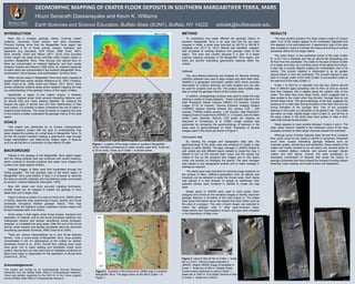
Figure 3. (above) Alluvial fan in Crater 1. Scale
bar is 2.5 km. Themis image projected in
JMARS. (Right) HiRISE image of landslide in
Crater 1. Scale bar is 500 m. (Middle Right)
Fluvial erosion featured on wall of Crater 1.
Scale bar is 1000 m. (Far Right) Texture of floor
in Crater 3. Scale bar is 500 m.
METHOD
To understand how water affected the geologic history of
southern Margaritifer Terra in an area that had not yet been
mapped in detail, a study area bounded by 343.76 to 345.56 E
longitude and -25.11 to -23.61 latitude was identified, mapped,
and compared to existing literature and geologic maps of the
region. This area was chosen because it is part of a larger
ongoing mapping campaign in the Margaritifer Terra region, and
there are several interesting geomorphic features within the
craters.
Software
The Java Mission-planning and Analysis for Remote Sensing
(JMARS) software was used to align images and other Mars data.
JMARS is a geospatial information system (GIS) which provides
information for mission planning and data analysis and can also
be used for projects such as this. This project used multiple data
sets to reveal the geologic history of the chosen area.
In addition, photogeologic analysis was used to create the map
utilizing a variety of image datasets. These included data from the
High Resolution Stereo Camera (HRSC) (10 m/pixel), Context
Imager (CTX) (6 m/pixel), Thermal Emission Imaging System
(THEMIS) daytime thermal infrared (IR) camera (100 – 230
m/pixel), THEMIS visible camera (~20 m/pixel), High Resolution
Imaging Science Experiment (HiRISE) (1.3 m/pixel), and the Mars
Obiter Laser Altimeter (MOLA) (128 pixels per degree) as
described in Christensen et al. (2009). Image analysis was
performed by comparing the geomorphology of features in the
study area to geomorphology on Earth. Examples of several
images used in this study are shown in Figure 3.
Geomorphic Map
By viewing the images and topographic data sets, the
geomorphology of the study area was analyzed to create a map
(Figure 4) within JMARS. The layer manager in JMARS helped to
add, delete and edit different layers needed to create the map. It
helped to turn on the relevant layer maps, and the opacity bar
helped to line up the polygons and images and to see layers
under one another by changing the opacity. The layer manager
also helped to plot topographic profiles and to make changes in
settings as required.
The stamp layer was important for showing image locations on
the surface of Mars. Different parameters such as latitude and
longitude can be selected to study the chosen area. Each stamp
was opened in a web browser to assess its usefulness, then
selected stamps were rendered in JMARS to create the map
base.
Shape layers in JMARS were used to draw points, lines,
polygons and circles on the rendered images to identify important
geologic features in formation of the map (Figure 4). The shape
layer gives information about the shapes that were drawn such as
the area of a polygon. The color of each shape was selected to
match the geologic units in other peer-reviewed maps.
Observations and interpretations of each unit type were compiled
in the Description of Map Units.
RESULTS
The area studied contains five large impact craters of various
ages. Four of the craters appear to be moderately degraded and
one appears to be well-preserved. A geomorphic map of the area
was compiled in order to consider the nature and timing of surface
processes within the five large craters.
The crater Dison, in the southwest corner of the map (Crater
5), is 20.7 km in diameter and has an alluvial fan emanating onto
its floor from the southeast. The crater to the east of Dison (Crater
4) is larger and older, as it contains some of the ejecta from Dison.
It also has a smooth deposit coating the northwestern part of its
interior. This smooth material is interpreted to be an aeolian
deposit blown in from the northwest. This smooth deposit is also
seen in a larger crater to the north (Crater 3) and another crater to
the east end of the map (Crater 1).
Crater 1 is 38.8 km in diameter and has four distinct alluvial
fans of different ages spreading onto its floor as well as several
fans that coalesce into a bajada along the eastern side of the
crater. The older fans have steep fronts, which suggests that a
lake existed in the crater when they formed. Younger fans do not
exhibit steep fronts. The geomorphology of the fans suggests the
presence of a crater lake during formation of the older fans but not
during formation of the younger fans. One of the youngest
features in this crater is a landslide on its eastern wall. This crater
lies within an older, slightly larger crater (Crater 2), and all five of
the large craters in the study area have gullies or rilles in their
walls that indicate fluvial erosion.
Water appears to have ponded between Craters 2 and 4. The
older valley network material in the northwest corner of the map
probably connects to other larger channels toward the northwest.
Although some of these features likely formed from overland
flow, some could be the result of rainfall or snowmelt. Snowmelt
could have caused interesting geologic features such as
channels, gullies, alluvial fans and landslides. Areas outside of the
craters are mostly covered by an old plains unit, several areas of
older cratered plateau material, and several younger impact
craters and their ejecta. Overall, this area possesses an
interesting combination of features that reveal the history of
geologic processes that have shaped the surface including impact
cratering, mass wasting, and fluvial erosion and deposition.
INTRODUCTION
Mars has a complex geologic history involving impact
cratering, volcanoes, fluvial erosion, and other processes.
Previous findings show that the Margaritifer Terra region has
experienced a lot of fluvial activity, erosion, transport, and
deposition (e.g. Saunders, 1979; Parker, 1985; Grant, 1987).
More recently, Grant and Wilson (2011; 2012) have provided
further insight into water-driven activities within impact craters in
southern Margaritifer Terra. They discuss how alluvial fans on
Mars are concentrated on cratered highlands, and their results
enhance Howard and Moore’s 2005 study on cratered highlands
on Mars which are concentrated in the southern Margaritifer Terra,
southwestern Terra Sabaea, and southwestern Tyrrhena Terra.
While various areas in Margaritifer Terra have been mapped at
greater detail than earlier studies (Williams et al., 2007; Fortezzo,
2009; Grant et al., 2009; Grant and Wilson, 2011, 2012), there
remain additional cratered areas where detailed mapping will help
our understanding of the geologic history of this region of Mars.
Specifically, a region of five craters (Figure 1) between
previously mapped areas holds several interesting features such
as alluvial fans and mass wasting deposits. By studying the
shapes and ages of alluvial fans and their relationships to their
host craters, it is possible to better understand the role of water in
shaping these features. This study focusses on mapping this area
of five craters to better understand the geologic history of the local
region.
BACKGROUND
Interest in the geology of the Margaritifer Terra region began
with the Viking program and has continued with recent missions,
which continue to provide evidence that water once shaped the
surface over large regions of Mars.
Detailed images of Mars were first transmitted through the
Viking program. The first geologic map of the entire region of
Margaritifer Terra used Mariner 9 data (1-2 km/pixel) to describe
the area as smooth materials and mountainous areas surrounded
by ancient, cratered highlands (Saunders, 1979).
Now with newer and more accurate mapping techniques,
smaller areas can be mapped to explain the geology in more
detail than over a larger area.
Figure 2 shows a portion of a map by Grant et al. (2009) where
a heavily dissected area experienced impact, aeolian and fluvial
processes throughout Martian geologic history. Their map
indicates that the highland surface underwent severe impact and
fluvial processes early in its history.
Some areas in that region show fluvial erosion, transport and
deposition of material, and as the fluvial processes declined, two
widespread volcanic and aeolian resurfacing events embayed,
subdued, or inundated low lying areas. After the end of the fluvial
activity, small impacts and aeolian processes were the dominant
resurfacing processes (Fortezzo, 2009; Grant et al, 2009)
There are various interpretations as to how fluvial features
formed. One, in some areas of Margaritifer Terra, snow possibly
concentrated in the rim depressions of the craters by aeolian
processes (Grant et al., 2012). Runoff from melting snow could
have given rise to mass wasting and landslides inside some
craters. Alluvial fans can also hold clues to habitable conditions on
Mars since water is responsible for the deposition of alluvial fans
(Grant et al., 2012).
GOALS
This project was performed as an 8-week undergraduate
summer research project with the goal of understanding how
water shaped the surface of a small area in Margaritifer Terra. To
do this the project included creating a geomorphic map through
image interpretation and determining relative ages of features
such as alluvial fans in connection to past effects of water
Acknowledgements
This project was funded by an Undergraduate Summer Research
Fellowship from the Buffalo State Office of Undergraduate Research.
Travel was partially supported by the GSA On to the Future program
and the Buffalo State Office of Undergraduate Research.
Figure 2. A portion of the Grant et al. (2009) map in southern
Margaritfer Terra. The large crater on the left is Crater 1 in
Figure 1.
Figure 1. Location of five large craters in southern Margaritifer
Terra. Numbers correspond to crater number used here. Scale bar
is 25 km wide. Close up of Crater 1 is shown below.
1
5
4
3
2