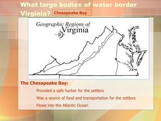
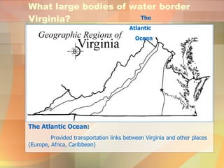
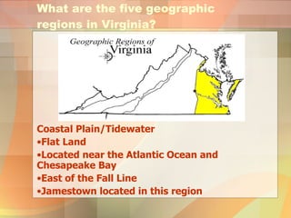
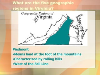
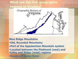
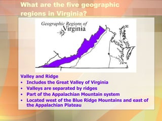
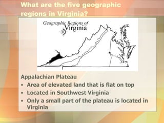
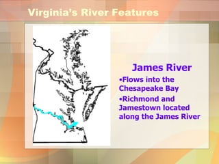
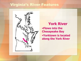
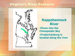
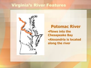
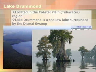
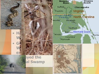
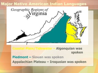
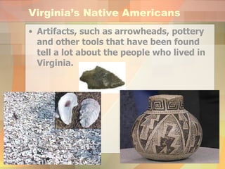
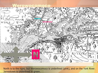
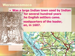
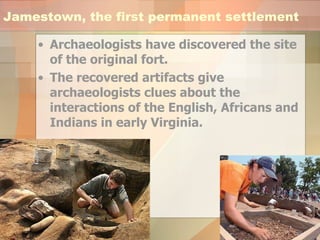
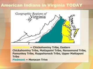
Virginia Studies Review VS.2a-g Created by Sarah Duncan, Social Studies Specialist Portsmouth Public Schools 2008
What large bodies of water border Virginia? Chesapeake Bay The Chesapeake Bay: Provided a safe harbor for the settlers Was a source of food and transportation for the settlers Flows into the Atlantic Ocean
What large bodies of water border Virginia? The Atlantic Ocean: Provided transportation links between Virginia and other places (Europe, Africa, Caribbean) The  Atlantic  Ocean
What states border Virginia? Maryland West Virginia Kentucky Tennessee North Carolina Virginia
What are the five geographic regions in Virginia? Coastal Plain/Tidewater Flat Land Located near the Atlantic Ocean and Chesapeake Bay East of the Fall Line Jamestown located in this region
What are the five geographic regions in Virginia? Piedmont  Means land at the foot of the mountains Characterized by rolling hills West of the Fall Line
What are the five geographic regions in Virginia? Blue Ridge Mountains Old, Rounded Mountains Part of the Appalachian Mountain system Located between the Piedmont (east) and Valley and Ridge (west) regions Source of many rivers
Valley and Ridge  Includes the Great Valley of Virginia Valleys are separated by ridges Part of the Appalachian Mountain system Located west of the Blue Ridge Mountains and east of the Appalachian Plateau What are the five geographic regions in Virginia?
Appalachian Plateau Area of elevated land that is flat on top Located in Southwest Virginia Only a small part of the plateau is located in Virginia What are the five geographic regions in Virginia?
Virginia’s River Features James River Flows into the Chesapeake Bay Richmond and Jamestown located along the James River
Virginia’s River Features York River Flows into the Chesapeake Bay Yorktown is located along the York River
Virginia’s River Features Rappahannock River Flows into the Chesapeake Bay Fredericksburg is located along the river
Virginia’s River Features Potomac River Flows into the Chesapeake Bay Alexandria is located along the river
Each river was a source of food and provided a pathway for exploration and settlement of Virginia. Virginia’s River Features All rivers flow east into the Chesapeake Bay.
Lake Drummond Located in the Coastal Plain (Tidewater) region Lake Drummond is a shallow lake surrounded by the Dismal Swamp
Dismal Swamp Located in the Coastal Plain/Tidewater Region Has a Variety of Wildlife George Washington explored and surveyed the Dismal Swamp
Major Native American Indian Languages Coastal Plain/Tidewater –  Algonquian was  spoken Piedmont –  Siouan was spoken Appalachian Plateau – Iroquoian was spoken
Virginia’s Native Americans Christopher Columbus called the people he found “Indians” because he thought he was in the Indies!! Spain San Salvador Where he landed! Indies Where he thought he was!
Virginia’s Native Americans Artifacts, such as arrowheads, pottery and other tools that have been found tell a lot about the people who lived in Virginia.
Virginia’s Climate The climate in Virginia is relatively mild with distinct seasons—spring, summer, fall and winter—resulting in a variety of vegetation.   Spring Fall Winter Summer
Adaptations to the Environment The kinds of food the Native Americans ate, the clothing they wore, and the shelters they lived in was all dependent on their environment: Clothing was made from deer skins
Shelter was made from trees, animals and other materials Adaptations to the Environment
Foods Changed with the Seasons: In the winter, the Native Americans hunted birds and animals.
In the Spring , Native Americans fished and picked berries. Foods Changed with the Seasons:
Foods Changed with the Seasons: In the summer, Native Americans grew crops. Beans, corn and  pumpkins
Werowocomoco North is to the right, but Werowocomoco is underlined (pink), and on the York River. Jamestown is underlined in green.
Was a large Indian town used by Indian leaders for several hundred years before the English settlers came.  It was headquarters of the leader, Powhatan, in 1607.  Werowocomoco
Jamestown, the first permanent settlement Archaeologists have discovered the site of the original fort.  The recovered artifacts give archaeologists clues about the interactions of the English, Africans and Indians in early Virginia.
American Indians in Virginia TODAY Coastal Plain  ~ Chickahominy Tribe, Eastern Chickahominy Tribe, Mattapoini Tribe, Nansemond Tribe, Pamunkey Tribe, Rappahanock Tribe, Upper Mattaponi Tribe Piedmont  ~ Monacan Trive
Review Questions What large bodies of water border Virginia? A Atlantic Ocean and Pacific Ocean B Chesapeake Bay and Shenandoah River C Atlantic Ocean and Chesapeake Bay  D Chesapeake Bay and Indian Ocean C
Which of the following states border Virginia? A Pennsylvania and Maryland B West Virginia and Georgia C Tennessee and North Carolina  D Kentucky and South Carolina Review Questions C
Review Questions Which two regions of Virginia are separated by the Fall Line? A Appalachian Plateau and Blue Ridge Mountains B Piedmont and Blue Ridge Mountains C Coastal Plain and Piedmont  D Blue Ridge Mountains and Piedmont C
Review Questions Which is a characteristic of the Coastal Plain (Tidewater)? A Flat land  B Old rounded mountains C Valleys D Plateau A
Review Questions Which of the following regions has waterfalls that prevent further travel on the river? A Piedmont  B Appalachian Plateau C Coastal Plain D Blue Ridge Mountain A
Review Questions What region borders the Piedmont to the west? A Coastal Plain B Appalachian Plateau C Blue Ridge Mountains  D Valley and Ridge C
Review Questions Which region is a source of many Virginia rivers? A Coastal Plain B Blue Ridge Mountains  C Eastern Shore D Appalachian Plateau B
Review Questions Which of the following is part of the Appalachian Mountain system? A Coastal Plain and Piedmont B Piedmont and Appalachian Plateau C Valley and Ridge and Appalachian Plateau  D Valley and Ridge and Coastal Plain C
Review Questions What body of water provided transportation links between Virginia and Europe? A James River B Atlantic Ocean  C Chesapeake Bay D Potomac River B
Review Questions Arrowheads, pottery, and tools are examples of __________  that prove American Indians lived in all areas of Virginia. A artifacts  B journals C diaries D documents A

Vs2 review, 2008[1]

  • 1.
    Virginia Studies ReviewVS.2a-g Created by Sarah Duncan, Social Studies Specialist Portsmouth Public Schools 2008
  • 2.
    What large bodiesof water border Virginia? Chesapeake Bay The Chesapeake Bay: Provided a safe harbor for the settlers Was a source of food and transportation for the settlers Flows into the Atlantic Ocean
  • 3.
    What large bodiesof water border Virginia? The Atlantic Ocean: Provided transportation links between Virginia and other places (Europe, Africa, Caribbean) The Atlantic Ocean
  • 4.
    What states borderVirginia? Maryland West Virginia Kentucky Tennessee North Carolina Virginia
  • 5.
    What are thefive geographic regions in Virginia? Coastal Plain/Tidewater Flat Land Located near the Atlantic Ocean and Chesapeake Bay East of the Fall Line Jamestown located in this region
  • 6.
    What are thefive geographic regions in Virginia? Piedmont Means land at the foot of the mountains Characterized by rolling hills West of the Fall Line
  • 7.
    What are thefive geographic regions in Virginia? Blue Ridge Mountains Old, Rounded Mountains Part of the Appalachian Mountain system Located between the Piedmont (east) and Valley and Ridge (west) regions Source of many rivers
  • 8.
    Valley and Ridge Includes the Great Valley of Virginia Valleys are separated by ridges Part of the Appalachian Mountain system Located west of the Blue Ridge Mountains and east of the Appalachian Plateau What are the five geographic regions in Virginia?
  • 9.
    Appalachian Plateau Areaof elevated land that is flat on top Located in Southwest Virginia Only a small part of the plateau is located in Virginia What are the five geographic regions in Virginia?
  • 10.
    Virginia’s River FeaturesJames River Flows into the Chesapeake Bay Richmond and Jamestown located along the James River
  • 11.
    Virginia’s River FeaturesYork River Flows into the Chesapeake Bay Yorktown is located along the York River
  • 12.
    Virginia’s River FeaturesRappahannock River Flows into the Chesapeake Bay Fredericksburg is located along the river
  • 13.
    Virginia’s River FeaturesPotomac River Flows into the Chesapeake Bay Alexandria is located along the river
  • 14.
    Each river wasa source of food and provided a pathway for exploration and settlement of Virginia. Virginia’s River Features All rivers flow east into the Chesapeake Bay.
  • 15.
    Lake Drummond Locatedin the Coastal Plain (Tidewater) region Lake Drummond is a shallow lake surrounded by the Dismal Swamp
  • 16.
    Dismal Swamp Locatedin the Coastal Plain/Tidewater Region Has a Variety of Wildlife George Washington explored and surveyed the Dismal Swamp
  • 17.
    Major Native AmericanIndian Languages Coastal Plain/Tidewater – Algonquian was spoken Piedmont – Siouan was spoken Appalachian Plateau – Iroquoian was spoken
  • 18.
    Virginia’s Native AmericansChristopher Columbus called the people he found “Indians” because he thought he was in the Indies!! Spain San Salvador Where he landed! Indies Where he thought he was!
  • 19.
    Virginia’s Native AmericansArtifacts, such as arrowheads, pottery and other tools that have been found tell a lot about the people who lived in Virginia.
  • 20.
    Virginia’s Climate Theclimate in Virginia is relatively mild with distinct seasons—spring, summer, fall and winter—resulting in a variety of vegetation. Spring Fall Winter Summer
  • 21.
    Adaptations to theEnvironment The kinds of food the Native Americans ate, the clothing they wore, and the shelters they lived in was all dependent on their environment: Clothing was made from deer skins
  • 22.
    Shelter was madefrom trees, animals and other materials Adaptations to the Environment
  • 23.
    Foods Changed withthe Seasons: In the winter, the Native Americans hunted birds and animals.
  • 24.
    In the Spring, Native Americans fished and picked berries. Foods Changed with the Seasons:
  • 25.
    Foods Changed withthe Seasons: In the summer, Native Americans grew crops. Beans, corn and pumpkins
  • 26.
    Werowocomoco North isto the right, but Werowocomoco is underlined (pink), and on the York River. Jamestown is underlined in green.
  • 27.
    Was a largeIndian town used by Indian leaders for several hundred years before the English settlers came. It was headquarters of the leader, Powhatan, in 1607. Werowocomoco
  • 28.
    Jamestown, the firstpermanent settlement Archaeologists have discovered the site of the original fort. The recovered artifacts give archaeologists clues about the interactions of the English, Africans and Indians in early Virginia.
  • 29.
    American Indians inVirginia TODAY Coastal Plain ~ Chickahominy Tribe, Eastern Chickahominy Tribe, Mattapoini Tribe, Nansemond Tribe, Pamunkey Tribe, Rappahanock Tribe, Upper Mattaponi Tribe Piedmont ~ Monacan Trive
  • 30.
    Review Questions Whatlarge bodies of water border Virginia? A Atlantic Ocean and Pacific Ocean B Chesapeake Bay and Shenandoah River C Atlantic Ocean and Chesapeake Bay D Chesapeake Bay and Indian Ocean C
  • 31.
    Which of thefollowing states border Virginia? A Pennsylvania and Maryland B West Virginia and Georgia C Tennessee and North Carolina D Kentucky and South Carolina Review Questions C
  • 32.
    Review Questions Whichtwo regions of Virginia are separated by the Fall Line? A Appalachian Plateau and Blue Ridge Mountains B Piedmont and Blue Ridge Mountains C Coastal Plain and Piedmont D Blue Ridge Mountains and Piedmont C
  • 33.
    Review Questions Whichis a characteristic of the Coastal Plain (Tidewater)? A Flat land B Old rounded mountains C Valleys D Plateau A
  • 34.
    Review Questions Whichof the following regions has waterfalls that prevent further travel on the river? A Piedmont B Appalachian Plateau C Coastal Plain D Blue Ridge Mountain A
  • 35.
    Review Questions Whatregion borders the Piedmont to the west? A Coastal Plain B Appalachian Plateau C Blue Ridge Mountains D Valley and Ridge C
  • 36.
    Review Questions Whichregion is a source of many Virginia rivers? A Coastal Plain B Blue Ridge Mountains C Eastern Shore D Appalachian Plateau B
  • 37.
    Review Questions Whichof the following is part of the Appalachian Mountain system? A Coastal Plain and Piedmont B Piedmont and Appalachian Plateau C Valley and Ridge and Appalachian Plateau D Valley and Ridge and Coastal Plain C
  • 38.
    Review Questions Whatbody of water provided transportation links between Virginia and Europe? A James River B Atlantic Ocean C Chesapeake Bay D Potomac River B
  • 39.
    Review Questions Arrowheads,pottery, and tools are examples of __________ that prove American Indians lived in all areas of Virginia. A artifacts B journals C diaries D documents A

Editor's Notes

  • #16 http://2.bp.blogspot.com/_JvvB6-2vDC8/SLIgLHRl4uI/AAAAAAAACLA/oFvYrIErgNU/s400/lake+drummond.jpg http://www.oceanvoyaging.com/Entries/Images/October09/DismalSwamp/LakeDrummond_large.jpg
  • #17 http://gradschool.unc.edu/programs/royster/explorenc/northeast/northeast/dismalswamp.html http://www.dpughphoto.com/images/white-tailed%20deer%20great%20dismal%20swamp%20sp%20121908%201.JPG
  • #19 http://www.vr3.co.uk/vr3/images/world_map.jpg
  • #20 http://www.fotosearch.com/thumb/IMP/IMP161/INGPCYHE0167.jpg http://www.pbs.org/wgbh/pages/roadshow/tips/images/indian_art/2_lg.jpg http://www.bcgov.net/oystershells.jpg
  • #22 http://www.old-town.org/nos/Pictures/H-636.jpg
  • #23 http://content.answers.com/main/content/wp/en/7/79/Jamestownsettlement.JPG
  • #24 http://pelotes.jea.com/NativeAmerican/LeMoyne/stag%20hunting.gif
  • #25 http://www.looseleafnotes.com/notes/2006/06/ http://www.archives.gov/research/native-americans/pictures/images/indians-057a.jpg
  • #26 http://images.jupiterimages.com/common/detail/82/90/23039082.jpg http://www.wilfertfarms.com/adm/ktmlstandard/images/uploads/sm_corn.jpg http://hinterlander.typepad.com/photos/uncategorized/long_beans_004.JPG
  • #28 http://www.virginiaplaces.org/vacities/graphics/purtanbay.gif
  • #29 http://media.hamptonroads.com/media/content/pilotonline/2006/11/dtburials1a.jpg http://magazine.clas.virginia.edu/images/FieldSchool0610.jpg