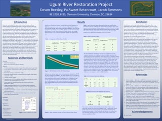
SlideShare a Scribd company logo
RESEARCH POSTER PRESENTATION DESIGN © 2015
www.PosterPresentations.com
Guam has been plagued for many years with soil erosion problems,
causing serious environmental problems, affecting navigation along the
rivers and the fresh water quality. The Ugum River watershed is a 4,672
acre watershed located in the southern region of Guam that is composed of
rolling hills and very steep slopes. The Guam Waterworks Authority is
allowed to pump 4 million gallons of water per day from the Ugum River
to their treatment facility; however, the operating cost has increased due to
high water turbidity. Water that is not treated in the facility makes its way
into the estuary and reef environment at the river outlet where a direct
decline in the coral reef health has been observed due to excessive
sediment loading upstream. Some secondary effects include decreased fish
populations and tourism. In this project, a 5.5 acre portion of the watershed
on a highly eroded portion of the Ugum River was isolated and analyzed
for current erosion rates using WEPP (Water Erosion Prediction Project)
Software with data collected from Web Soil Survey database and with
hand calculations. The project goal is to reduce rainfall erosion volumes to
significantly less than acceptable rates, which is 2 tons/acre/year for
Agfayan clay, by regrading the land and planting native ground covers.
Both of these work to reduce soil erodibility factor and the velocity of
runoff. Restoring the most damaged portions of the Ugum River should
reduce the total sediment loading and function to decrease stress on the
reef and water treatment plant.
Introduction
Materials and Methods
The average annual precipitation, runoff, and erosion are displayed in
Table 1; a snapshot from the model is shown as Figure 2. The Agfayan
clay soil type from the area of interest was not available in WEPP, so soil
composition parameters were specified. Hawaii was chosen for location
data because it has the closest latitude to Guam. Notably, the average
annual soil loss is 2 to 3 times the allowable quantity for Agfayan clay
soil.
Table 1: Comparison of Three Slope Profiles
Figure 2: WEEP Model for 60%-30% Mixed Slopes
Sediment loss during various storm events was also calculated by WEPP,
the data is displayed in Figure 2. The daily sediment loss is very high for
both 30% and 60% slopes, even for a 2 year return period storm. For a 50
year return period storm the daily sediment loss is a ridiculously high
average of 34 tons/acre/day. However, this data is even lower than
theoretically expected as the location information for Hawaii provides
lower runoff rainfall erosivity factor (R) and soil erodibility factor (K)
than Guam.
Figure 3: Daily Sediment Leaving for Three Different Slope Values
Results Conclusion
Initial erosion rates on the analyzed portion of the Ugum River were
magnitudes higher than the allowable annual and daily soil loss values.
Two restoration plans were derived to reduce these values to acceptable
levels. First, a new cover management plan was modeled which reduced
the maximum annual soil loss to 4 tons/acre/year. Since further reduction
was necessary, terraces were implemented resulting in a new maximum
annual soil loss of 1.95 tons, thus achieving the restoration goal.
Restoration should be completed to within a few feet of river level to
compensate for swelling during heavy storms.
For the revegetation aspect of the restoration, research was done on native
plants that would thrive in the riparian zone surrounding rivers and will
benefit the local ecosystem. Osmoxylon mariannense is a critically
endangered tree species in Guam and the Northern Mariana Islands.
Planting endangered species, especially along riversides will maximize
their capacity to propagate downstream. Coccinia grandis, the ivy gourd,
also known as baby watermelon is a vine species native to Guam that will
quickly provide ground cover and seasonal fruit for the fauna. Another
valuable groundcover would be a clubmoss, such as staghorn clubmoss
(Lycopodiella cernua), which primarily grows streamside. Additionally
Acrostichum aureum, the golden leather fern, is a large species of fern that
grows in mangrove swamps and other wet locations which will provide a
large vegetative surface area to impede direct rainfall impact.
This proposed restoration plan successfully remediated the excessive
erosion occurring along 700 feet of the Ugum river while also promoting
the overall health of the local ecosystem. Some assumptions had to be
made while modeling the environmental factors, but the results still
provide a reliable average representation of geologic and hydrologic
conditions. While this is only a small portion of the Ugum River, scaling
up this project would mitigate the elevated sediment and nutrient loading
that is damaging the estuary aquatic life and remove pressure from the
Guam Waterworks Authority treatment facility. Despite the fact that this is
a solution, the ever increasing amounts of severe weather events could
warrant more extreme remediation efforts.
References
1. Khosrowpanah, S. & Jocson, J. (2005) Environmental Assessment for
Non-Point Sources of Pollution for Ugum Watershed. University of
Guam, Water and Environmental Research Institute (WERI), Technical
Report 109.
2. Khosrowpanah, S. & Heitz, L. F. (2001) Rainfall Erosivity Erosivity
Factors (R-Factors) For Selected Islands in the Federated States of
Micronesia. University of Guam, Water and Environmental Research
Institute (WERI), Technical Report 92.
3. Khosrowpanah, S. (2018) Soil erosion Monitoring program. University
of Guam, Water and Environmental Research Institute (WERI).
4. Lucas, J. & Gawel, A. M. (2018) Plants of Guam and CNMI.
iNaturalist Network. http://www.inaturalist.org/guides/4082
5. . Haddock, R. (2016) Urolithiasis, Urinary Cancer, and Home Drinking
Water Source in the United States Territory of Guam, 2006–2010. Int J
Environ Res Public Health.
6. Ward, P. & Hoffard S. (1965) Ugum River in The Hydrology of Guam
(pp. H7-H8). Washington D.C. U.S. Government Printing Office.
7. Ridgell, C. (2016) Santa Rita Residents Face Erosion of Property From
River. Pacific News Center. https://pacificnewscenter.com/santa-rita-
residents-face-erosion-of-property-from-river/.
Acknowledgements
Dr. Tom Owino
Materials:
• USDA Web Soil Survey
• Water Erosion Prediction Project (WEPP)
Methods
1. Perform preliminary analysis of Ugum Watershed using Google Earth.
2. Locate heavily eroded portion of the Ugum River using USDA Web
Soil Survey.
3. Determine soil type, composition, depth,
4. Determine rainfall erosivity, watershed traverse lengths, slope angles,
and profile width.
5. Average traverse lengths
6. Input data into WEPP to calculate daily sediment leaving and volume
runoff for each segment of the survey area.
7. Check values by calculating erosion and volume runoff using
Equations 1 and 2.
8. Model remediation options in WEPP and using hand calculations
including grading of terraces, lowering the cover management factor
with ground covers.
9. Consider supplemental ecosystem restoration like planting endangered
native plant species.
10. Determine optimal restoration plan and compare new erosion and
runoff rates to original profile.
Equation 1
Q=
(𝑃−0.2𝑆)2
(𝑃+0.8𝑆)
Equation 2
T=RKLSCP
Where T= total soil loss
R= Runoff Erosivity
K= Erodibility
LS= Length/Slope Factor Figure 1: Area of Interest Soil Types
C= Cover Management
P= Preservation Practices
BE 3220, EEES, Clemson University, Clemson, SC, 29634
Devon Beesley, Pa-Sweet Betancourt, Jacob Simmons
Ugum River Restoration Project
Average Annual
Precipitation (mm)
Average Annual Runoff
(mm)
Average Annual Soil Loss
(tons/acre)
30% Slopes 501.91 152.9 4.135
60% Slopes 501.91 153.09 6.098
50% Split 501.91 153.07 4.926
Percent Slope
Rate of Erosion
(tons/acre-year)
Average Runoff (in)
Average Precipitation
(in)
30% 56.43 82.59 85
60% 107.34 82.59 85
Mix 81.89 82.59 85
Erosion
Calculations
R K LS C P T
30% 600 0.24 4.9 0.003 1 2.12
60% 600 0.24 9.32 0.003 1 4.03
30%-60%
mix
600 0.24 7.11 0.003 1 3.07
Percent Slope
Soil Loss with 1
Terrace (tons/acre-
year)
Soil Loss with 2 Terraces
(tons/acre-year)
30% 1.58 1.24
60% 2.88 1.95
30%-60% mix 2.23 1.73
Table 2, below, shows the hand calculated Erosion and Runoff values.
Runoff erosivity (R), erodibility (K), and annual precipitation values were
found in reviewed literature (Khosrowpanah et al, 2001, 2005, 2018). Hand
calculated values are much larger and more realistic than the WEPP values.
The erosion tolerance of the soil was 2 tons/acre-year, therefore both
models call for significant remediation efforts to be made
Table 2: Hand Calculated Values
The first method for remediating this area was to mulch the current
vegetation and plant new endangered species of plants and plants that
would succeed in this environment. Since there will be a vegetative canopy,
the modified universal soil loss equation could not be used. Instead a cover
management factor of 0.003 was used assuming a 1.5 foot canopy with
100% ground cover, which is simulated by the thick mulch layer. The
calculations for this approach are shown in Table 3. This implementation
reduced total annual soil loss to a maximum of 4 tons per acre. This is 26
times less erosion than before restorative efforts, but is still more than the
allowable 2 tons/acre/year for the Agfayan Clay soil type. Terraces are the
next factor that can be implemented to reduce erosion. Data could not be
found for terrace sediment delivery ratios on slopes greater than 25% so the
highest ratio was assumed to apply to 30% and 60% slopes. The soil loss
with one or two terraces is shown in Table 4 below.
Table 3: Soil Erosion Value with Mulching
Table 4: Soil Erosion with Mulching and Terracing
Two terraces combined with mulching and replanting of native plants
effectively reduced the erosion to acceptable levels. A third terrace would
further reduce on site erosion but may not be possible considering the
average traverse length is 88 ft. Despite the fact that this is a solution, the
ever increasing amounts of severe weather events could warrant more
extreme remediation efforts.

More Related Content

What's hot

Implementation of In-Stream, Streambank and Riparian Practices in Conjunction...
Implementation of In-Stream, Streambank and Riparian Practices in Conjunction...Implementation of In-Stream, Streambank and Riparian Practices in Conjunction...
Implementation of In-Stream, Streambank and Riparian Practices in Conjunction...
National Institute of Food and Agriculture
 
Water Quality and Productivity Enhancement in an Irrigated River Basin throug...
Water Quality and Productivity Enhancement in an Irrigated River Basin throug...Water Quality and Productivity Enhancement in an Irrigated River Basin throug...
Water Quality and Productivity Enhancement in an Irrigated River Basin throug...
National Institute of Food and Agriculture
 
Watershed management practices and hydrological modelling under changing clim...
Watershed management practices and hydrological modelling under changing clim...Watershed management practices and hydrological modelling under changing clim...
Watershed management practices and hydrological modelling under changing clim...
africa-rising
 
Analysis of Conservation Practice Effectiveness and Producer Adoption Behavio...
Analysis of Conservation Practice Effectiveness and Producer Adoption Behavio...Analysis of Conservation Practice Effectiveness and Producer Adoption Behavio...
Analysis of Conservation Practice Effectiveness and Producer Adoption Behavio...
National Institute of Food and Agriculture
 
Sedimentation assessment of a small reservoir at afaka forest reserve, kaduna...
Sedimentation assessment of a small reservoir at afaka forest reserve, kaduna...Sedimentation assessment of a small reservoir at afaka forest reserve, kaduna...
Sedimentation assessment of a small reservoir at afaka forest reserve, kaduna...
Alexander Decker
 
SPRINGER IWRM Published
SPRINGER IWRM PublishedSPRINGER IWRM Published
SPRINGER IWRM PublishedRotem Sade
 
Water Quality and Productivity Enhancement in an Irrigated River Basin throug...
Water Quality and Productivity Enhancement in an Irrigated River Basin throug...Water Quality and Productivity Enhancement in an Irrigated River Basin throug...
Water Quality and Productivity Enhancement in an Irrigated River Basin throug...
National Institute of Food and Agriculture
 
Impacts of On-site Wastewater Treatment Systems on Water Quality and Quantity...
Impacts of On-site Wastewater Treatment Systems on Water Quality and Quantity...Impacts of On-site Wastewater Treatment Systems on Water Quality and Quantity...
Impacts of On-site Wastewater Treatment Systems on Water Quality and Quantity...
National Institute of Food and Agriculture
 
Coupling Solid-Aqueous-Gas Phases of Carbon and Nitrogen Across Topographic G...
Coupling Solid-Aqueous-Gas Phases of Carbon and Nitrogen Across Topographic G...Coupling Solid-Aqueous-Gas Phases of Carbon and Nitrogen Across Topographic G...
Coupling Solid-Aqueous-Gas Phases of Carbon and Nitrogen Across Topographic G...
National Institute of Food and Agriculture
 
Universal soil loss equation
Universal soil loss equationUniversal soil loss equation
Universal soil loss equation
SUSHMA TAMTA
 
Integrated Plan for Drought Preparedness and Mitigation, and Water Conservati...
Integrated Plan for Drought Preparedness and Mitigation, and Water Conservati...Integrated Plan for Drought Preparedness and Mitigation, and Water Conservati...
Integrated Plan for Drought Preparedness and Mitigation, and Water Conservati...
National Institute of Food and Agriculture
 
Regional-Scale Assessment of N2O Emissions within the US Corn Belt: The Impac...
Regional-Scale Assessment of N2O Emissions within the US Corn Belt: The Impac...Regional-Scale Assessment of N2O Emissions within the US Corn Belt: The Impac...
Regional-Scale Assessment of N2O Emissions within the US Corn Belt: The Impac...
National Institute of Food and Agriculture
 
An Integrative Decision Support System for Managing Water Resources under Inc...
An Integrative Decision Support System for Managing Water Resources under Inc...An Integrative Decision Support System for Managing Water Resources under Inc...
An Integrative Decision Support System for Managing Water Resources under Inc...
National Institute of Food and Agriculture
 
Managing Critical Source Areas for Enhancing Ecosystem Services in Agricultur...
Managing Critical Source Areas for Enhancing Ecosystem Services in Agricultur...Managing Critical Source Areas for Enhancing Ecosystem Services in Agricultur...
Managing Critical Source Areas for Enhancing Ecosystem Services in Agricultur...
National Institute of Food and Agriculture
 
Improved Assessment of Nitrogen and Phosphorus Fate and Transport for Irrigat...
Improved Assessment of Nitrogen and Phosphorus Fate and Transport for Irrigat...Improved Assessment of Nitrogen and Phosphorus Fate and Transport for Irrigat...
Improved Assessment of Nitrogen and Phosphorus Fate and Transport for Irrigat...
National Institute of Food and Agriculture
 
Modeling the Effects of Land Use Change on Flooding
Modeling the Effects of Land Use Change on FloodingModeling the Effects of Land Use Change on Flooding
Modeling the Effects of Land Use Change on Flooding
Adam Nayak
 
Land use land cover impacts
Land use land cover impactsLand use land cover impacts
Land use land cover impacts
Soil and Water Conservation Society
 
Krider - Prioritizing Watersheds for PMP Placement
Krider - Prioritizing Watersheds for PMP PlacementKrider - Prioritizing Watersheds for PMP Placement
Krider - Prioritizing Watersheds for PMP Placement
Soil and Water Conservation Society
 
Consequences Of Stand Age And Structure On Forest Water Yield
Consequences Of Stand Age And Structure On Forest Water Yield     Consequences Of Stand Age And Structure On Forest Water Yield
Consequences Of Stand Age And Structure On Forest Water Yield
National Institute of Food and Agriculture
 
Large Runoff Flux And Transformation of Particulate Nitrogen (Pn) Following L...
Large Runoff Flux And Transformation of Particulate Nitrogen (Pn) Following L...Large Runoff Flux And Transformation of Particulate Nitrogen (Pn) Following L...
Large Runoff Flux And Transformation of Particulate Nitrogen (Pn) Following L...
National Institute of Food and Agriculture
 

What's hot (20)

Implementation of In-Stream, Streambank and Riparian Practices in Conjunction...
Implementation of In-Stream, Streambank and Riparian Practices in Conjunction...Implementation of In-Stream, Streambank and Riparian Practices in Conjunction...
Implementation of In-Stream, Streambank and Riparian Practices in Conjunction...
 
Water Quality and Productivity Enhancement in an Irrigated River Basin throug...
Water Quality and Productivity Enhancement in an Irrigated River Basin throug...Water Quality and Productivity Enhancement in an Irrigated River Basin throug...
Water Quality and Productivity Enhancement in an Irrigated River Basin throug...
 
Watershed management practices and hydrological modelling under changing clim...
Watershed management practices and hydrological modelling under changing clim...Watershed management practices and hydrological modelling under changing clim...
Watershed management practices and hydrological modelling under changing clim...
 
Analysis of Conservation Practice Effectiveness and Producer Adoption Behavio...
Analysis of Conservation Practice Effectiveness and Producer Adoption Behavio...Analysis of Conservation Practice Effectiveness and Producer Adoption Behavio...
Analysis of Conservation Practice Effectiveness and Producer Adoption Behavio...
 
Sedimentation assessment of a small reservoir at afaka forest reserve, kaduna...
Sedimentation assessment of a small reservoir at afaka forest reserve, kaduna...Sedimentation assessment of a small reservoir at afaka forest reserve, kaduna...
Sedimentation assessment of a small reservoir at afaka forest reserve, kaduna...
 
SPRINGER IWRM Published
SPRINGER IWRM PublishedSPRINGER IWRM Published
SPRINGER IWRM Published
 
Water Quality and Productivity Enhancement in an Irrigated River Basin throug...
Water Quality and Productivity Enhancement in an Irrigated River Basin throug...Water Quality and Productivity Enhancement in an Irrigated River Basin throug...
Water Quality and Productivity Enhancement in an Irrigated River Basin throug...
 
Impacts of On-site Wastewater Treatment Systems on Water Quality and Quantity...
Impacts of On-site Wastewater Treatment Systems on Water Quality and Quantity...Impacts of On-site Wastewater Treatment Systems on Water Quality and Quantity...
Impacts of On-site Wastewater Treatment Systems on Water Quality and Quantity...
 
Coupling Solid-Aqueous-Gas Phases of Carbon and Nitrogen Across Topographic G...
Coupling Solid-Aqueous-Gas Phases of Carbon and Nitrogen Across Topographic G...Coupling Solid-Aqueous-Gas Phases of Carbon and Nitrogen Across Topographic G...
Coupling Solid-Aqueous-Gas Phases of Carbon and Nitrogen Across Topographic G...
 
Universal soil loss equation
Universal soil loss equationUniversal soil loss equation
Universal soil loss equation
 
Integrated Plan for Drought Preparedness and Mitigation, and Water Conservati...
Integrated Plan for Drought Preparedness and Mitigation, and Water Conservati...Integrated Plan for Drought Preparedness and Mitigation, and Water Conservati...
Integrated Plan for Drought Preparedness and Mitigation, and Water Conservati...
 
Regional-Scale Assessment of N2O Emissions within the US Corn Belt: The Impac...
Regional-Scale Assessment of N2O Emissions within the US Corn Belt: The Impac...Regional-Scale Assessment of N2O Emissions within the US Corn Belt: The Impac...
Regional-Scale Assessment of N2O Emissions within the US Corn Belt: The Impac...
 
An Integrative Decision Support System for Managing Water Resources under Inc...
An Integrative Decision Support System for Managing Water Resources under Inc...An Integrative Decision Support System for Managing Water Resources under Inc...
An Integrative Decision Support System for Managing Water Resources under Inc...
 
Managing Critical Source Areas for Enhancing Ecosystem Services in Agricultur...
Managing Critical Source Areas for Enhancing Ecosystem Services in Agricultur...Managing Critical Source Areas for Enhancing Ecosystem Services in Agricultur...
Managing Critical Source Areas for Enhancing Ecosystem Services in Agricultur...
 
Improved Assessment of Nitrogen and Phosphorus Fate and Transport for Irrigat...
Improved Assessment of Nitrogen and Phosphorus Fate and Transport for Irrigat...Improved Assessment of Nitrogen and Phosphorus Fate and Transport for Irrigat...
Improved Assessment of Nitrogen and Phosphorus Fate and Transport for Irrigat...
 
Modeling the Effects of Land Use Change on Flooding
Modeling the Effects of Land Use Change on FloodingModeling the Effects of Land Use Change on Flooding
Modeling the Effects of Land Use Change on Flooding
 
Land use land cover impacts
Land use land cover impactsLand use land cover impacts
Land use land cover impacts
 
Krider - Prioritizing Watersheds for PMP Placement
Krider - Prioritizing Watersheds for PMP PlacementKrider - Prioritizing Watersheds for PMP Placement
Krider - Prioritizing Watersheds for PMP Placement
 
Consequences Of Stand Age And Structure On Forest Water Yield
Consequences Of Stand Age And Structure On Forest Water Yield     Consequences Of Stand Age And Structure On Forest Water Yield
Consequences Of Stand Age And Structure On Forest Water Yield
 
Large Runoff Flux And Transformation of Particulate Nitrogen (Pn) Following L...
Large Runoff Flux And Transformation of Particulate Nitrogen (Pn) Following L...Large Runoff Flux And Transformation of Particulate Nitrogen (Pn) Following L...
Large Runoff Flux And Transformation of Particulate Nitrogen (Pn) Following L...
 

Similar to Ugum River Project

Lulc dynamics
Lulc dynamicsLulc dynamics
Lulc dynamics
patelamit355
 
Soil erosion and water storage
Soil erosion and water storage Soil erosion and water storage
Soil erosion and water storage
Soil and Water Conservation Society
 
Soil and Water Conservation Engineering.ppt
Soil and Water Conservation Engineering.pptSoil and Water Conservation Engineering.ppt
Soil and Water Conservation Engineering.ppt
Ayele Akuma
 
Erosion poster
Erosion posterErosion poster
Erosion poster
smwolfe
 
Impact of climate on groundwater
Impact of climate on groundwaterImpact of climate on groundwater
Impact of climate on groundwater
Prof. A.Balasubramanian
 
Ugum river
Ugum riverUgum river
Ugum river
PaSweetBetancourt
 
Southeast Asia Conference 08
Southeast Asia Conference 08Southeast Asia Conference 08
Southeast Asia Conference 08
Victor Zapanta Manlapaz
 
Soil water, irrigation and climate change
Soil water, irrigation and climate changeSoil water, irrigation and climate change
Soil water, irrigation and climate changeVarduhi Surmalyan
 
Assessment of Ecosystem Services in a Semi-arid Agriculture-dominant Area: Fr...
Assessment of Ecosystem Services in a Semi-arid Agriculture-dominant Area: Fr...Assessment of Ecosystem Services in a Semi-arid Agriculture-dominant Area: Fr...
Assessment of Ecosystem Services in a Semi-arid Agriculture-dominant Area: Fr...
Ramesh Dhungel
 
Dr. Jay Famiglietti - 21st Century Water Security and Implications for Animal...
Dr. Jay Famiglietti - 21st Century Water Security and Implications for Animal...Dr. Jay Famiglietti - 21st Century Water Security and Implications for Animal...
Dr. Jay Famiglietti - 21st Century Water Security and Implications for Animal...
John Blue
 
Accounting for Wetlands Loss in a Changing Climate in the Estimation of Long...
Accounting for Wetlands Loss in a  Changing Climate in the Estimation of Long...Accounting for Wetlands Loss in a  Changing Climate in the Estimation of Long...
Accounting for Wetlands Loss in a Changing Climate in the Estimation of Long...
Sergey Gulbin
 
Be 3220 poster final
Be 3220 poster finalBe 3220 poster final
Be 3220 poster final
MichaelSmith808947
 
Assessment, analysis and study of encroachments and change in natural water f...
Assessment, analysis and study of encroachments and change in natural water f...Assessment, analysis and study of encroachments and change in natural water f...
Assessment, analysis and study of encroachments and change in natural water f...
eSAT Journals
 
CIEEMInPracticeSept2014_Skinner
CIEEMInPracticeSept2014_SkinnerCIEEMInPracticeSept2014_Skinner
CIEEMInPracticeSept2014_SkinnerAlice Hastie
 
Ceap upper washita basin
Ceap upper washita basinCeap upper washita basin
Ceap upper washita basin
Soil and Water Conservation Society
 
Bv31291295
Bv31291295Bv31291295
Bv31291295IJMER
 
Lessons Learned From The Everglades Sjr Summit 2010 09 15 Esterson+Landers
Lessons Learned From The Everglades Sjr Summit 2010 09 15 Esterson+LandersLessons Learned From The Everglades Sjr Summit 2010 09 15 Esterson+Landers
Lessons Learned From The Everglades Sjr Summit 2010 09 15 Esterson+Landers
Kris Esterson
 

Similar to Ugum River Project (20)

Lulc dynamics
Lulc dynamicsLulc dynamics
Lulc dynamics
 
Poster Presentations
Poster PresentationsPoster Presentations
Poster Presentations
 
Soil erosion and water storage
Soil erosion and water storage Soil erosion and water storage
Soil erosion and water storage
 
Soil and Water Conservation Engineering.ppt
Soil and Water Conservation Engineering.pptSoil and Water Conservation Engineering.ppt
Soil and Water Conservation Engineering.ppt
 
Erosion poster
Erosion posterErosion poster
Erosion poster
 
Impact of climate on groundwater
Impact of climate on groundwaterImpact of climate on groundwater
Impact of climate on groundwater
 
Ugum river
Ugum riverUgum river
Ugum river
 
Southeast Asia Conference 08
Southeast Asia Conference 08Southeast Asia Conference 08
Southeast Asia Conference 08
 
Soil water, irrigation and climate change
Soil water, irrigation and climate changeSoil water, irrigation and climate change
Soil water, irrigation and climate change
 
Assessment of Ecosystem Services in a Semi-arid Agriculture-dominant Area: Fr...
Assessment of Ecosystem Services in a Semi-arid Agriculture-dominant Area: Fr...Assessment of Ecosystem Services in a Semi-arid Agriculture-dominant Area: Fr...
Assessment of Ecosystem Services in a Semi-arid Agriculture-dominant Area: Fr...
 
Dr. Jay Famiglietti - 21st Century Water Security and Implications for Animal...
Dr. Jay Famiglietti - 21st Century Water Security and Implications for Animal...Dr. Jay Famiglietti - 21st Century Water Security and Implications for Animal...
Dr. Jay Famiglietti - 21st Century Water Security and Implications for Animal...
 
Accounting for Wetlands Loss in a Changing Climate in the Estimation of Long...
Accounting for Wetlands Loss in a  Changing Climate in the Estimation of Long...Accounting for Wetlands Loss in a  Changing Climate in the Estimation of Long...
Accounting for Wetlands Loss in a Changing Climate in the Estimation of Long...
 
Be 3220 poster final
Be 3220 poster finalBe 3220 poster final
Be 3220 poster final
 
Assessment, analysis and study of encroachments and change in natural water f...
Assessment, analysis and study of encroachments and change in natural water f...Assessment, analysis and study of encroachments and change in natural water f...
Assessment, analysis and study of encroachments and change in natural water f...
 
CIEEMInPracticeSept2014_Skinner
CIEEMInPracticeSept2014_SkinnerCIEEMInPracticeSept2014_Skinner
CIEEMInPracticeSept2014_Skinner
 
Ceap upper washita basin
Ceap upper washita basinCeap upper washita basin
Ceap upper washita basin
 
Bv31291295
Bv31291295Bv31291295
Bv31291295
 
Lessons Learned From The Everglades Sjr Summit 2010 09 15 Esterson+Landers
Lessons Learned From The Everglades Sjr Summit 2010 09 15 Esterson+LandersLessons Learned From The Everglades Sjr Summit 2010 09 15 Esterson+Landers
Lessons Learned From The Everglades Sjr Summit 2010 09 15 Esterson+Landers
 
GIS 2 poster
GIS 2 posterGIS 2 poster
GIS 2 poster
 
Writing Sample
Writing SampleWriting Sample
Writing Sample
 

Recently uploaded

H.Seo, ICLR 2024, MLILAB, KAIST AI.pdf
H.Seo,  ICLR 2024, MLILAB,  KAIST AI.pdfH.Seo,  ICLR 2024, MLILAB,  KAIST AI.pdf
H.Seo, ICLR 2024, MLILAB, KAIST AI.pdf
MLILAB
 
Industrial Training at Shahjalal Fertilizer Company Limited (SFCL)
Industrial Training at Shahjalal Fertilizer Company Limited (SFCL)Industrial Training at Shahjalal Fertilizer Company Limited (SFCL)
Industrial Training at Shahjalal Fertilizer Company Limited (SFCL)
MdTanvirMahtab2
 
power quality voltage fluctuation UNIT - I.pptx
power quality voltage fluctuation UNIT - I.pptxpower quality voltage fluctuation UNIT - I.pptx
power quality voltage fluctuation UNIT - I.pptx
ViniHema
 
一比一原版(SFU毕业证)西蒙菲莎大学毕业证成绩单如何办理
一比一原版(SFU毕业证)西蒙菲莎大学毕业证成绩单如何办理一比一原版(SFU毕业证)西蒙菲莎大学毕业证成绩单如何办理
一比一原版(SFU毕业证)西蒙菲莎大学毕业证成绩单如何办理
bakpo1
 
Top 10 Oil and Gas Projects in Saudi Arabia 2024.pdf
Top 10 Oil and Gas Projects in Saudi Arabia 2024.pdfTop 10 Oil and Gas Projects in Saudi Arabia 2024.pdf
Top 10 Oil and Gas Projects in Saudi Arabia 2024.pdf
Teleport Manpower Consultant
 
Sachpazis:Terzaghi Bearing Capacity Estimation in simple terms with Calculati...
Sachpazis:Terzaghi Bearing Capacity Estimation in simple terms with Calculati...Sachpazis:Terzaghi Bearing Capacity Estimation in simple terms with Calculati...
Sachpazis:Terzaghi Bearing Capacity Estimation in simple terms with Calculati...
Dr.Costas Sachpazis
 
block diagram and signal flow graph representation
block diagram and signal flow graph representationblock diagram and signal flow graph representation
block diagram and signal flow graph representation
Divya Somashekar
 
The Benefits and Techniques of Trenchless Pipe Repair.pdf
The Benefits and Techniques of Trenchless Pipe Repair.pdfThe Benefits and Techniques of Trenchless Pipe Repair.pdf
The Benefits and Techniques of Trenchless Pipe Repair.pdf
Pipe Restoration Solutions
 
Governing Equations for Fundamental Aerodynamics_Anderson2010.pdf
Governing Equations for Fundamental Aerodynamics_Anderson2010.pdfGoverning Equations for Fundamental Aerodynamics_Anderson2010.pdf
Governing Equations for Fundamental Aerodynamics_Anderson2010.pdf
WENKENLI1
 
road safety engineering r s e unit 3.pdf
road safety engineering  r s e unit 3.pdfroad safety engineering  r s e unit 3.pdf
road safety engineering r s e unit 3.pdf
VENKATESHvenky89705
 
Gen AI Study Jams _ For the GDSC Leads in India.pdf
Gen AI Study Jams _ For the GDSC Leads in India.pdfGen AI Study Jams _ For the GDSC Leads in India.pdf
Gen AI Study Jams _ For the GDSC Leads in India.pdf
gdsczhcet
 
Planning Of Procurement o different goods and services
Planning Of Procurement o different goods and servicesPlanning Of Procurement o different goods and services
Planning Of Procurement o different goods and services
JoytuBarua2
 
Pile Foundation by Venkatesh Taduvai (Sub Geotechnical Engineering II)-conver...
Pile Foundation by Venkatesh Taduvai (Sub Geotechnical Engineering II)-conver...Pile Foundation by Venkatesh Taduvai (Sub Geotechnical Engineering II)-conver...
Pile Foundation by Venkatesh Taduvai (Sub Geotechnical Engineering II)-conver...
AJAYKUMARPUND1
 
space technology lecture notes on satellite
space technology lecture notes on satellitespace technology lecture notes on satellite
space technology lecture notes on satellite
ongomchris
 
Final project report on grocery store management system..pdf
Final project report on grocery store management system..pdfFinal project report on grocery store management system..pdf
Final project report on grocery store management system..pdf
Kamal Acharya
 
Hierarchical Digital Twin of a Naval Power System
Hierarchical Digital Twin of a Naval Power SystemHierarchical Digital Twin of a Naval Power System
Hierarchical Digital Twin of a Naval Power System
Kerry Sado
 
Nuclear Power Economics and Structuring 2024
Nuclear Power Economics and Structuring 2024Nuclear Power Economics and Structuring 2024
Nuclear Power Economics and Structuring 2024
Massimo Talia
 
Runway Orientation Based on the Wind Rose Diagram.pptx
Runway Orientation Based on the Wind Rose Diagram.pptxRunway Orientation Based on the Wind Rose Diagram.pptx
Runway Orientation Based on the Wind Rose Diagram.pptx
SupreethSP4
 
DESIGN A COTTON SEED SEPARATION MACHINE.docx
DESIGN A COTTON SEED SEPARATION MACHINE.docxDESIGN A COTTON SEED SEPARATION MACHINE.docx
DESIGN A COTTON SEED SEPARATION MACHINE.docx
FluxPrime1
 
Standard Reomte Control Interface - Neometrix
Standard Reomte Control Interface - NeometrixStandard Reomte Control Interface - Neometrix
Standard Reomte Control Interface - Neometrix
Neometrix_Engineering_Pvt_Ltd
 

Recently uploaded (20)

H.Seo, ICLR 2024, MLILAB, KAIST AI.pdf
H.Seo,  ICLR 2024, MLILAB,  KAIST AI.pdfH.Seo,  ICLR 2024, MLILAB,  KAIST AI.pdf
H.Seo, ICLR 2024, MLILAB, KAIST AI.pdf
 
Industrial Training at Shahjalal Fertilizer Company Limited (SFCL)
Industrial Training at Shahjalal Fertilizer Company Limited (SFCL)Industrial Training at Shahjalal Fertilizer Company Limited (SFCL)
Industrial Training at Shahjalal Fertilizer Company Limited (SFCL)
 
power quality voltage fluctuation UNIT - I.pptx
power quality voltage fluctuation UNIT - I.pptxpower quality voltage fluctuation UNIT - I.pptx
power quality voltage fluctuation UNIT - I.pptx
 
一比一原版(SFU毕业证)西蒙菲莎大学毕业证成绩单如何办理
一比一原版(SFU毕业证)西蒙菲莎大学毕业证成绩单如何办理一比一原版(SFU毕业证)西蒙菲莎大学毕业证成绩单如何办理
一比一原版(SFU毕业证)西蒙菲莎大学毕业证成绩单如何办理
 
Top 10 Oil and Gas Projects in Saudi Arabia 2024.pdf
Top 10 Oil and Gas Projects in Saudi Arabia 2024.pdfTop 10 Oil and Gas Projects in Saudi Arabia 2024.pdf
Top 10 Oil and Gas Projects in Saudi Arabia 2024.pdf
 
Sachpazis:Terzaghi Bearing Capacity Estimation in simple terms with Calculati...
Sachpazis:Terzaghi Bearing Capacity Estimation in simple terms with Calculati...Sachpazis:Terzaghi Bearing Capacity Estimation in simple terms with Calculati...
Sachpazis:Terzaghi Bearing Capacity Estimation in simple terms with Calculati...
 
block diagram and signal flow graph representation
block diagram and signal flow graph representationblock diagram and signal flow graph representation
block diagram and signal flow graph representation
 
The Benefits and Techniques of Trenchless Pipe Repair.pdf
The Benefits and Techniques of Trenchless Pipe Repair.pdfThe Benefits and Techniques of Trenchless Pipe Repair.pdf
The Benefits and Techniques of Trenchless Pipe Repair.pdf
 
Governing Equations for Fundamental Aerodynamics_Anderson2010.pdf
Governing Equations for Fundamental Aerodynamics_Anderson2010.pdfGoverning Equations for Fundamental Aerodynamics_Anderson2010.pdf
Governing Equations for Fundamental Aerodynamics_Anderson2010.pdf
 
road safety engineering r s e unit 3.pdf
road safety engineering  r s e unit 3.pdfroad safety engineering  r s e unit 3.pdf
road safety engineering r s e unit 3.pdf
 
Gen AI Study Jams _ For the GDSC Leads in India.pdf
Gen AI Study Jams _ For the GDSC Leads in India.pdfGen AI Study Jams _ For the GDSC Leads in India.pdf
Gen AI Study Jams _ For the GDSC Leads in India.pdf
 
Planning Of Procurement o different goods and services
Planning Of Procurement o different goods and servicesPlanning Of Procurement o different goods and services
Planning Of Procurement o different goods and services
 
Pile Foundation by Venkatesh Taduvai (Sub Geotechnical Engineering II)-conver...
Pile Foundation by Venkatesh Taduvai (Sub Geotechnical Engineering II)-conver...Pile Foundation by Venkatesh Taduvai (Sub Geotechnical Engineering II)-conver...
Pile Foundation by Venkatesh Taduvai (Sub Geotechnical Engineering II)-conver...
 
space technology lecture notes on satellite
space technology lecture notes on satellitespace technology lecture notes on satellite
space technology lecture notes on satellite
 
Final project report on grocery store management system..pdf
Final project report on grocery store management system..pdfFinal project report on grocery store management system..pdf
Final project report on grocery store management system..pdf
 
Hierarchical Digital Twin of a Naval Power System
Hierarchical Digital Twin of a Naval Power SystemHierarchical Digital Twin of a Naval Power System
Hierarchical Digital Twin of a Naval Power System
 
Nuclear Power Economics and Structuring 2024
Nuclear Power Economics and Structuring 2024Nuclear Power Economics and Structuring 2024
Nuclear Power Economics and Structuring 2024
 
Runway Orientation Based on the Wind Rose Diagram.pptx
Runway Orientation Based on the Wind Rose Diagram.pptxRunway Orientation Based on the Wind Rose Diagram.pptx
Runway Orientation Based on the Wind Rose Diagram.pptx
 
DESIGN A COTTON SEED SEPARATION MACHINE.docx
DESIGN A COTTON SEED SEPARATION MACHINE.docxDESIGN A COTTON SEED SEPARATION MACHINE.docx
DESIGN A COTTON SEED SEPARATION MACHINE.docx
 
Standard Reomte Control Interface - Neometrix
Standard Reomte Control Interface - NeometrixStandard Reomte Control Interface - Neometrix
Standard Reomte Control Interface - Neometrix
 

Ugum River Project

  • 1. RESEARCH POSTER PRESENTATION DESIGN © 2015 www.PosterPresentations.com Guam has been plagued for many years with soil erosion problems, causing serious environmental problems, affecting navigation along the rivers and the fresh water quality. The Ugum River watershed is a 4,672 acre watershed located in the southern region of Guam that is composed of rolling hills and very steep slopes. The Guam Waterworks Authority is allowed to pump 4 million gallons of water per day from the Ugum River to their treatment facility; however, the operating cost has increased due to high water turbidity. Water that is not treated in the facility makes its way into the estuary and reef environment at the river outlet where a direct decline in the coral reef health has been observed due to excessive sediment loading upstream. Some secondary effects include decreased fish populations and tourism. In this project, a 5.5 acre portion of the watershed on a highly eroded portion of the Ugum River was isolated and analyzed for current erosion rates using WEPP (Water Erosion Prediction Project) Software with data collected from Web Soil Survey database and with hand calculations. The project goal is to reduce rainfall erosion volumes to significantly less than acceptable rates, which is 2 tons/acre/year for Agfayan clay, by regrading the land and planting native ground covers. Both of these work to reduce soil erodibility factor and the velocity of runoff. Restoring the most damaged portions of the Ugum River should reduce the total sediment loading and function to decrease stress on the reef and water treatment plant. Introduction Materials and Methods The average annual precipitation, runoff, and erosion are displayed in Table 1; a snapshot from the model is shown as Figure 2. The Agfayan clay soil type from the area of interest was not available in WEPP, so soil composition parameters were specified. Hawaii was chosen for location data because it has the closest latitude to Guam. Notably, the average annual soil loss is 2 to 3 times the allowable quantity for Agfayan clay soil. Table 1: Comparison of Three Slope Profiles Figure 2: WEEP Model for 60%-30% Mixed Slopes Sediment loss during various storm events was also calculated by WEPP, the data is displayed in Figure 2. The daily sediment loss is very high for both 30% and 60% slopes, even for a 2 year return period storm. For a 50 year return period storm the daily sediment loss is a ridiculously high average of 34 tons/acre/day. However, this data is even lower than theoretically expected as the location information for Hawaii provides lower runoff rainfall erosivity factor (R) and soil erodibility factor (K) than Guam. Figure 3: Daily Sediment Leaving for Three Different Slope Values Results Conclusion Initial erosion rates on the analyzed portion of the Ugum River were magnitudes higher than the allowable annual and daily soil loss values. Two restoration plans were derived to reduce these values to acceptable levels. First, a new cover management plan was modeled which reduced the maximum annual soil loss to 4 tons/acre/year. Since further reduction was necessary, terraces were implemented resulting in a new maximum annual soil loss of 1.95 tons, thus achieving the restoration goal. Restoration should be completed to within a few feet of river level to compensate for swelling during heavy storms. For the revegetation aspect of the restoration, research was done on native plants that would thrive in the riparian zone surrounding rivers and will benefit the local ecosystem. Osmoxylon mariannense is a critically endangered tree species in Guam and the Northern Mariana Islands. Planting endangered species, especially along riversides will maximize their capacity to propagate downstream. Coccinia grandis, the ivy gourd, also known as baby watermelon is a vine species native to Guam that will quickly provide ground cover and seasonal fruit for the fauna. Another valuable groundcover would be a clubmoss, such as staghorn clubmoss (Lycopodiella cernua), which primarily grows streamside. Additionally Acrostichum aureum, the golden leather fern, is a large species of fern that grows in mangrove swamps and other wet locations which will provide a large vegetative surface area to impede direct rainfall impact. This proposed restoration plan successfully remediated the excessive erosion occurring along 700 feet of the Ugum river while also promoting the overall health of the local ecosystem. Some assumptions had to be made while modeling the environmental factors, but the results still provide a reliable average representation of geologic and hydrologic conditions. While this is only a small portion of the Ugum River, scaling up this project would mitigate the elevated sediment and nutrient loading that is damaging the estuary aquatic life and remove pressure from the Guam Waterworks Authority treatment facility. Despite the fact that this is a solution, the ever increasing amounts of severe weather events could warrant more extreme remediation efforts. References 1. Khosrowpanah, S. & Jocson, J. (2005) Environmental Assessment for Non-Point Sources of Pollution for Ugum Watershed. University of Guam, Water and Environmental Research Institute (WERI), Technical Report 109. 2. Khosrowpanah, S. & Heitz, L. F. (2001) Rainfall Erosivity Erosivity Factors (R-Factors) For Selected Islands in the Federated States of Micronesia. University of Guam, Water and Environmental Research Institute (WERI), Technical Report 92. 3. Khosrowpanah, S. (2018) Soil erosion Monitoring program. University of Guam, Water and Environmental Research Institute (WERI). 4. Lucas, J. & Gawel, A. M. (2018) Plants of Guam and CNMI. iNaturalist Network. http://www.inaturalist.org/guides/4082 5. . Haddock, R. (2016) Urolithiasis, Urinary Cancer, and Home Drinking Water Source in the United States Territory of Guam, 2006–2010. Int J Environ Res Public Health. 6. Ward, P. & Hoffard S. (1965) Ugum River in The Hydrology of Guam (pp. H7-H8). Washington D.C. U.S. Government Printing Office. 7. Ridgell, C. (2016) Santa Rita Residents Face Erosion of Property From River. Pacific News Center. https://pacificnewscenter.com/santa-rita- residents-face-erosion-of-property-from-river/. Acknowledgements Dr. Tom Owino Materials: • USDA Web Soil Survey • Water Erosion Prediction Project (WEPP) Methods 1. Perform preliminary analysis of Ugum Watershed using Google Earth. 2. Locate heavily eroded portion of the Ugum River using USDA Web Soil Survey. 3. Determine soil type, composition, depth, 4. Determine rainfall erosivity, watershed traverse lengths, slope angles, and profile width. 5. Average traverse lengths 6. Input data into WEPP to calculate daily sediment leaving and volume runoff for each segment of the survey area. 7. Check values by calculating erosion and volume runoff using Equations 1 and 2. 8. Model remediation options in WEPP and using hand calculations including grading of terraces, lowering the cover management factor with ground covers. 9. Consider supplemental ecosystem restoration like planting endangered native plant species. 10. Determine optimal restoration plan and compare new erosion and runoff rates to original profile. Equation 1 Q= (𝑃−0.2𝑆)2 (𝑃+0.8𝑆) Equation 2 T=RKLSCP Where T= total soil loss R= Runoff Erosivity K= Erodibility LS= Length/Slope Factor Figure 1: Area of Interest Soil Types C= Cover Management P= Preservation Practices BE 3220, EEES, Clemson University, Clemson, SC, 29634 Devon Beesley, Pa-Sweet Betancourt, Jacob Simmons Ugum River Restoration Project Average Annual Precipitation (mm) Average Annual Runoff (mm) Average Annual Soil Loss (tons/acre) 30% Slopes 501.91 152.9 4.135 60% Slopes 501.91 153.09 6.098 50% Split 501.91 153.07 4.926 Percent Slope Rate of Erosion (tons/acre-year) Average Runoff (in) Average Precipitation (in) 30% 56.43 82.59 85 60% 107.34 82.59 85 Mix 81.89 82.59 85 Erosion Calculations R K LS C P T 30% 600 0.24 4.9 0.003 1 2.12 60% 600 0.24 9.32 0.003 1 4.03 30%-60% mix 600 0.24 7.11 0.003 1 3.07 Percent Slope Soil Loss with 1 Terrace (tons/acre- year) Soil Loss with 2 Terraces (tons/acre-year) 30% 1.58 1.24 60% 2.88 1.95 30%-60% mix 2.23 1.73 Table 2, below, shows the hand calculated Erosion and Runoff values. Runoff erosivity (R), erodibility (K), and annual precipitation values were found in reviewed literature (Khosrowpanah et al, 2001, 2005, 2018). Hand calculated values are much larger and more realistic than the WEPP values. The erosion tolerance of the soil was 2 tons/acre-year, therefore both models call for significant remediation efforts to be made Table 2: Hand Calculated Values The first method for remediating this area was to mulch the current vegetation and plant new endangered species of plants and plants that would succeed in this environment. Since there will be a vegetative canopy, the modified universal soil loss equation could not be used. Instead a cover management factor of 0.003 was used assuming a 1.5 foot canopy with 100% ground cover, which is simulated by the thick mulch layer. The calculations for this approach are shown in Table 3. This implementation reduced total annual soil loss to a maximum of 4 tons per acre. This is 26 times less erosion than before restorative efforts, but is still more than the allowable 2 tons/acre/year for the Agfayan Clay soil type. Terraces are the next factor that can be implemented to reduce erosion. Data could not be found for terrace sediment delivery ratios on slopes greater than 25% so the highest ratio was assumed to apply to 30% and 60% slopes. The soil loss with one or two terraces is shown in Table 4 below. Table 3: Soil Erosion Value with Mulching Table 4: Soil Erosion with Mulching and Terracing Two terraces combined with mulching and replanting of native plants effectively reduced the erosion to acceptable levels. A third terrace would further reduce on site erosion but may not be possible considering the average traverse length is 88 ft. Despite the fact that this is a solution, the ever increasing amounts of severe weather events could warrant more extreme remediation efforts.