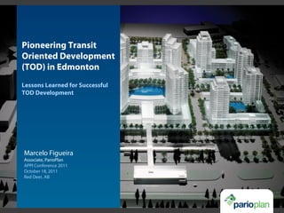
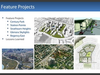
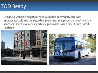
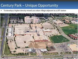
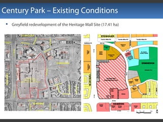
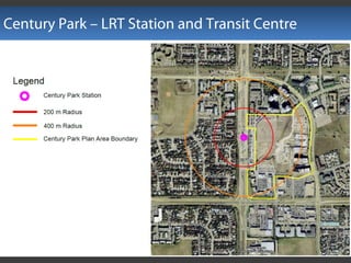
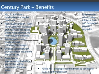
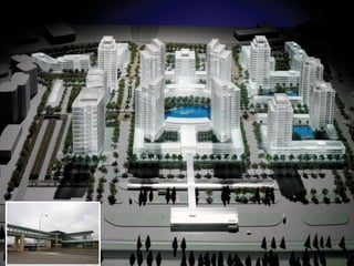
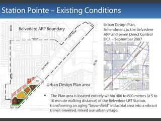
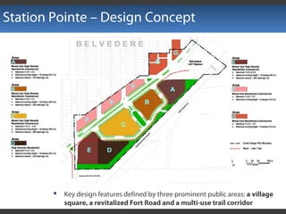
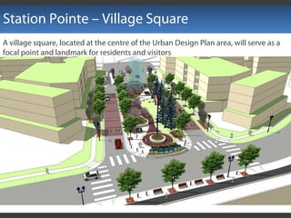
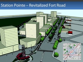
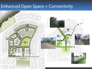
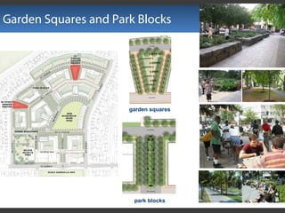
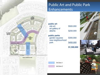
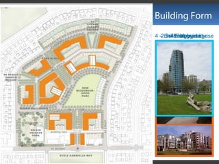
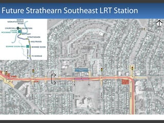
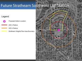
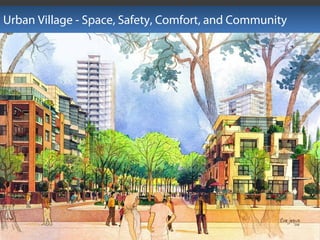
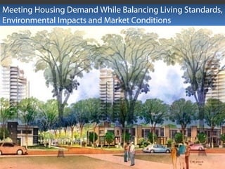
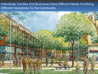
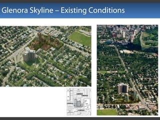
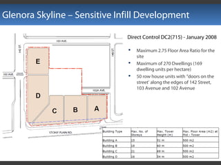
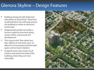
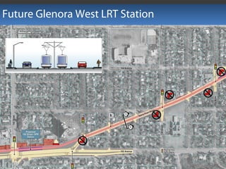
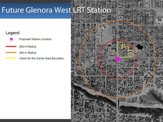
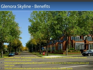
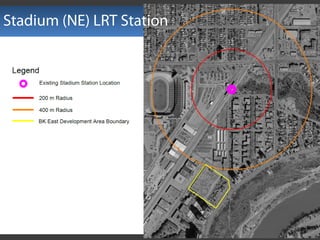
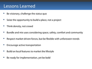
Pioneering Transit
Oriented Development
(TOD) in Edmonton
Lessons Learned for Successful
TOD Development
Marcelo Figueira
Associate, ParioPlan
APPI Conference 2011
October 18, 2011
Red Deer, AB
Who Are We?
ParioPlan Inc. award-winning
consulting in design and
development of urban infill sites
Interdisciplinary Efforts
Feature Projects
 Feature Projects
 Century Park
 Station Pointe
 Strathearn Heights
 Glenora Skylights
 Regency East
 Lessons Learned
TOD Ready
Designing walkable neighbourhoods around a community core with
appropriate scale and density, while providing great places and quality public
space, can meet several sustainability goals and assure a city’s future transit-
readiness
Century Park – Unique Opportunity
 To develop a higher density mixed use urban village adjacent to a LRT station
Century Park – Existing Conditions
 Greyfield redevelopment of the Heritage Mall Site (17.41 ha)
Century Park – LRT Station and Transit Centre
Century Park – Complete Community
Direct Control DC2(742) - February 2009
Area A - residential,
commercial and office mixed
use development including
low, mid, and high rise
apartments and row housing
and an amenity centre
Area B - row housing, low,
mid, and high rise apartment
buildings
Area C - street-oriented, low
scale commercial buildings
Century Park – Breaking the Grid
Century Park – Promoting Walkability
Century Park – Benefits
 Public Art – developers commitment to contribute
$0.60 a sq ft to public art
 Mix of Land Uses –
residential/commercial/
retail uses
 High Quality Design – Slim
towers allow for increased
ground level open space,
create visual interest and
reduce bulk of buildings.
 Streetscapes – active
residential and
commercial frontages.
 Gridded Street Network –
provides direct movement
within the site.
 Open Spaces –
approximately half of the
site (8.9 ha) will be
maintained for open
space.
 Development
uses existing
infrastructure
and developer
pays for
upgrades
Century Park
Station Pointe – Existing Conditions
 The Plan area is located entirely within 400 to 800 metres (a 5 to
10 minute walking distance) of the Belvedere LRT Station,
transforming an aging “brownfield” industrial area into a vibrant
transit oriented, mixed use urban village.
Urban Design Plan area
Belvedere ARP Boundary
Urban Design Plan,
Amendment to the Belvedere
ARP and seven Direct Control
DC1 – September 2007
Station Pointe – Design Concept
 Key design features defined by three prominent public areas: a village
square, a revitalized Fort Road and a multi-use trail corridor
Station Pointe – Village Square
A village square, located at the centre of the Urban Design Plan area, will serve as a
focal point and landmark for residents and visitors
Station Pointe – Revitalized Fort Road
Station Pointe – Multi-use Trail Corridor
 A series of small open spaces, grassed berms, ornamental planting beds,
landscaped buffers and shrub beds were incorporated into a cohesive linear park
system along the site’s eastern edge
 A total of 1.27 hectares (3.14 acres) has been provided for parks and open space
Station Pointe – Multi-use Trail Corridor
 A landscaped multi-use trail for walkers, joggers and cyclists will extend from 66
Street to the Belvedere LRT Station
Station Pointe – Design Features
 A variety of building forms
includes row houses, and
low, mid and high-rise
apartments
 Residential and mixed-use
buildings have been
oriented to reinforce the
street, parks and open
spaces.
 Shallow setbacks and
active retail and
residential frontages
provide ‘eyes on the
street’ to create a safe
environment
Station Pointe – Benefits
 Master planning and high
quality architectural and
public space design are
vital for the Urban Design
Plan area
 Streetscape environment
establishes a heightened
sense of place.
 Mid-block mews, plazas
and small playground
areas create opportunities
for casual social
interaction while
promoting safety in the
area
 Commitment to public art
- sculpture, murals, bas-
reliefs and graphics
Strathearn Heights
Strathearn Heights
Redevelopment Site
Edmonton
Downtown
North Saskatchewan River
Silver LEED for Neighbourhood
Development (LEED-ND) Stage 2
An Urban Village – a sustainable,
open, and affordable community
Strathearn Heights – Existing Conditions
Strathearn Heights – Complete Community
Direct Control DC2(716) - February 2008
Area A - row housing and stacked row housing
Area B - row housing, mid and high rise
apartment housing
Area C - row housing and stacked row housing
Area D - residential and commercial mixed-use
development including row housing, stacked row
housing, mid and high rise apartment housing,
live/work units, and a clubhouse/ amenity centre
 Maximum of 1,750 Dwelling units, where 5% (88 units) proposed to be sold to Habitat at 85%
of market and 62 units to be sold at market value
 Maximum 3.4 Floor Area Ratio for the entire site
 Maximum of 3,716 square metres of complementary small-scale commercial development
 1.25 ha of public parkland
Enhanced Open Space + Connectivity
 Context
Garden Squares and Park Blocks
garden squares
park blocks
Public Art and Public Park
Enhancements
public art
site art $500,000
art gallery of
alberta $250,000
public parks
garden squares $300,000
new neighbourhood
park $450,000
$1,500,000
2.5 – 3 storey edgeretail at grade
live - work
4 – 6 – 8 storey mid-riseslim high-rise
Building Form
Future Strathearn Southeast LRT Station
Strathearn Heights - Benefits
 Mixed-use, urban village concept
 Variety of open spaces and site amenities
 Pedestrian facilities and connections
throughout the development
 Variety of housing forms
 Quality of design and architectural
treatment
 Underground parking
 Location and scale of commercial uses;
 Transition in scale between development
on site and the surrounding properties
 Retention of mature boulevard trees and
the addition of other landscaping.
Urban Village - Space, Safety, Comfort, and Community
Meeting Housing Demand While Balancing Living Standards,
Environmental Impacts and Market Conditions
Individuals, Families And Businesses Have Different Needs And Bring
Different Aspirations To The Community
Glenora Skyline – Existing Conditions
Glenora Skyline – Sensitive Infill Development
Direct Control DC2(715) - January 2008
 Maximum 2.75 Floor Area Ratio for the
site
 Maximum of 270 Dwellings (169
dwelling units per hectare)
 50 row house units with “doors on the
street’ along the edges of 142 Street,
103 Avenue and 102 Avenue
Glenora Skyline - Single Harmonious Architectural Theme
Glenora Skyline – Design Concept
 A comprehensive
mixed-use
redevelopment located
on 4.1 acres at the
corner of 142 Street and
Stony Plain Road
 Low, medium and high-
rise residential uses are
complimented by
commercial and park /
open space uses
Glenora Skyline - Sun-Shadow and Rooftop Design
Glenora Skyline – Design Features
 Buildings designed with detail and
articulation at street level. Retail and
residential land uses will wrap around
the building to create an attractive
streetscape
 Stepped-back podium provides a
human-scaled environment along
streets within, and around, the
development
 Thin towers with floor plates less
than 500m2 at mid-tower zone to
allow for increased ground level open
space and narrower shadows
 Sculpted tower tops create visual
interest and reduce the bulk of the
buildings where they are most
noticeable
Future Glenora West LRT Station
Glenora Skyline - Benefits
 Pedestrian ”mews” and connections encourage walking to and from surrounding areas to access
commercial services and transit
 Extensive underground parking allows a portion of the site (0.4 ha) to be maintained for plazas and
open space
 $500,000 contribution for public art to be incorporated within the public spaces
Stadium (NE) LRT Station
Regency East – Opportunity
 Opportunity to advance a transit-
oriented development by taking
advantage of its proximity to the
Stadium LRT Station
 A combination of increased
residential densities, mixed use,
design excellence, and improved
connectivity create a self
sustaining community will be
catalyst to implement the
Stadium Station TOD Plan
 Design excellence applied to building
form enhances visual composition of
streets and skyline
 Human scale design applied to building
frontages augment pedestrian
experiences and provide passive
surveillance.
 Improve the public realm through
strategically placed artwork and urban
design features
Regency East – TOD Principles
Regency East – Design Concept
 slim high-rise towers
set back on mid- and
low-rise podiums
 articulated
architecture with
active frontages
 community art
gallery
 central plaza
Regency East – Design Concept
Direct Control DC2(752) - September 2009
 Floor Area Ratio: 8.0
 Building Height: 29, 32, 35 storeys
 Maximum of 1,000 Dwellings
 Row housing, work/live, Low-, mid-,
and high-rise apartments
 850 m2 (9,149 ft2 ) of indoor communal
amenity areas
 1,250 m2 (13,455 ft2 ) of outdoor
communal amenity areas
 Underground parking
 12,000 m2 (129,167 ft 2) of
neighbourhood retail
Regency East – Flexible Site Plan
 Towers can be relocated to adjust new
roadway and walkway paths to, from
and through the site
 The central plaza and the gallery can
be relocated, but their minimum size
must be maintained
 Parking can be reduced and
redesigned, but the number of access
and egress point must be maintained
 Building footprint, articulation and
location of active residential and
commercial frontages can be
redesigned and relocated to address
new roadway and walkway patterns
Regency East – Active Frontages
Regency East – Community Gallery
Regency East – Mixed-use
Regency East – Central Plaza
 The central plaza will
provide a family-oriented
amenity space, and the
community art gallery
and ground level active
retail frontages will
create a focal point for
residents and the public
Regency East – Central Plaza
How Often Do Cities Accommodate
Children And Seniors When It Comes To
Urban Design?
Regency East – Benefits
 Public art provision will be
implemented through two
opportunities - $100,000 for
purchased art and $815,000
towards structural art.
 $681,000 will be allocated to off-
site public amenities and
infrastructure, which will support
implementation of the Stadium
Station TOD Plan
 Public accessibility and
pedestrian connections
 Sustainable design strategies
equivalent to a Silver LEED
standard
Lessons Learned
 Be visionary, challenge the status quo
 Seize the opportunity to build a place, not a project
 Think density, not crowd
 Bundle and mix uses considering space, safety, comfort and community
 Respect market-driven forces, but be flexible with unforeseen trends
 Encourage active transportation
 Build on local features to market the lifestyle
 Be ready for implementation, yet be bold

Tod appi conference 2011 & evds 2012

  • 1.
    Pioneering Transit Oriented Development (TOD)in Edmonton Lessons Learned for Successful TOD Development Marcelo Figueira Associate, ParioPlan APPI Conference 2011 October 18, 2011 Red Deer, AB
  • 2.
    Who Are We? ParioPlanInc. award-winning consulting in design and development of urban infill sites
  • 3.
  • 4.
    Feature Projects  FeatureProjects  Century Park  Station Pointe  Strathearn Heights  Glenora Skylights  Regency East  Lessons Learned
  • 5.
    TOD Ready Designing walkableneighbourhoods around a community core with appropriate scale and density, while providing great places and quality public space, can meet several sustainability goals and assure a city’s future transit- readiness
  • 6.
    Century Park –Unique Opportunity  To develop a higher density mixed use urban village adjacent to a LRT station
  • 7.
    Century Park –Existing Conditions  Greyfield redevelopment of the Heritage Mall Site (17.41 ha)
  • 8.
    Century Park –LRT Station and Transit Centre
  • 9.
    Century Park –Complete Community Direct Control DC2(742) - February 2009 Area A - residential, commercial and office mixed use development including low, mid, and high rise apartments and row housing and an amenity centre Area B - row housing, low, mid, and high rise apartment buildings Area C - street-oriented, low scale commercial buildings
  • 10.
    Century Park –Breaking the Grid
  • 11.
    Century Park –Promoting Walkability
  • 12.
    Century Park –Benefits  Public Art – developers commitment to contribute $0.60 a sq ft to public art  Mix of Land Uses – residential/commercial/ retail uses  High Quality Design – Slim towers allow for increased ground level open space, create visual interest and reduce bulk of buildings.  Streetscapes – active residential and commercial frontages.  Gridded Street Network – provides direct movement within the site.  Open Spaces – approximately half of the site (8.9 ha) will be maintained for open space.  Development uses existing infrastructure and developer pays for upgrades
  • 13.
  • 14.
    Station Pointe –Existing Conditions  The Plan area is located entirely within 400 to 800 metres (a 5 to 10 minute walking distance) of the Belvedere LRT Station, transforming an aging “brownfield” industrial area into a vibrant transit oriented, mixed use urban village. Urban Design Plan area Belvedere ARP Boundary Urban Design Plan, Amendment to the Belvedere ARP and seven Direct Control DC1 – September 2007
  • 15.
    Station Pointe –Design Concept  Key design features defined by three prominent public areas: a village square, a revitalized Fort Road and a multi-use trail corridor
  • 16.
    Station Pointe –Village Square A village square, located at the centre of the Urban Design Plan area, will serve as a focal point and landmark for residents and visitors
  • 17.
    Station Pointe –Revitalized Fort Road
  • 18.
    Station Pointe –Multi-use Trail Corridor  A series of small open spaces, grassed berms, ornamental planting beds, landscaped buffers and shrub beds were incorporated into a cohesive linear park system along the site’s eastern edge  A total of 1.27 hectares (3.14 acres) has been provided for parks and open space
  • 19.
    Station Pointe –Multi-use Trail Corridor  A landscaped multi-use trail for walkers, joggers and cyclists will extend from 66 Street to the Belvedere LRT Station
  • 20.
    Station Pointe –Design Features  A variety of building forms includes row houses, and low, mid and high-rise apartments  Residential and mixed-use buildings have been oriented to reinforce the street, parks and open spaces.  Shallow setbacks and active retail and residential frontages provide ‘eyes on the street’ to create a safe environment
  • 21.
    Station Pointe –Benefits  Master planning and high quality architectural and public space design are vital for the Urban Design Plan area  Streetscape environment establishes a heightened sense of place.  Mid-block mews, plazas and small playground areas create opportunities for casual social interaction while promoting safety in the area  Commitment to public art - sculpture, murals, bas- reliefs and graphics
  • 22.
    Strathearn Heights Strathearn Heights RedevelopmentSite Edmonton Downtown North Saskatchewan River Silver LEED for Neighbourhood Development (LEED-ND) Stage 2 An Urban Village – a sustainable, open, and affordable community
  • 23.
    Strathearn Heights –Existing Conditions
  • 24.
    Strathearn Heights –Complete Community Direct Control DC2(716) - February 2008 Area A - row housing and stacked row housing Area B - row housing, mid and high rise apartment housing Area C - row housing and stacked row housing Area D - residential and commercial mixed-use development including row housing, stacked row housing, mid and high rise apartment housing, live/work units, and a clubhouse/ amenity centre  Maximum of 1,750 Dwelling units, where 5% (88 units) proposed to be sold to Habitat at 85% of market and 62 units to be sold at market value  Maximum 3.4 Floor Area Ratio for the entire site  Maximum of 3,716 square metres of complementary small-scale commercial development  1.25 ha of public parkland
  • 25.
    Enhanced Open Space+ Connectivity  Context
  • 26.
    Garden Squares andPark Blocks garden squares park blocks
  • 27.
    Public Art andPublic Park Enhancements public art site art $500,000 art gallery of alberta $250,000 public parks garden squares $300,000 new neighbourhood park $450,000 $1,500,000
  • 28.
    2.5 – 3storey edgeretail at grade live - work 4 – 6 – 8 storey mid-riseslim high-rise Building Form
  • 29.
  • 30.
  • 31.
    Strathearn Heights -Benefits  Mixed-use, urban village concept  Variety of open spaces and site amenities  Pedestrian facilities and connections throughout the development  Variety of housing forms  Quality of design and architectural treatment  Underground parking  Location and scale of commercial uses;  Transition in scale between development on site and the surrounding properties  Retention of mature boulevard trees and the addition of other landscaping.
  • 32.
    Urban Village -Space, Safety, Comfort, and Community
  • 33.
    Meeting Housing DemandWhile Balancing Living Standards, Environmental Impacts and Market Conditions
  • 34.
    Individuals, Families AndBusinesses Have Different Needs And Bring Different Aspirations To The Community
  • 35.
    Glenora Skyline –Existing Conditions
  • 36.
    Glenora Skyline –Sensitive Infill Development Direct Control DC2(715) - January 2008  Maximum 2.75 Floor Area Ratio for the site  Maximum of 270 Dwellings (169 dwelling units per hectare)  50 row house units with “doors on the street’ along the edges of 142 Street, 103 Avenue and 102 Avenue
  • 37.
    Glenora Skyline -Single Harmonious Architectural Theme
  • 38.
    Glenora Skyline –Design Concept  A comprehensive mixed-use redevelopment located on 4.1 acres at the corner of 142 Street and Stony Plain Road  Low, medium and high- rise residential uses are complimented by commercial and park / open space uses
  • 39.
    Glenora Skyline -Sun-Shadow and Rooftop Design
  • 40.
    Glenora Skyline –Design Features  Buildings designed with detail and articulation at street level. Retail and residential land uses will wrap around the building to create an attractive streetscape  Stepped-back podium provides a human-scaled environment along streets within, and around, the development  Thin towers with floor plates less than 500m2 at mid-tower zone to allow for increased ground level open space and narrower shadows  Sculpted tower tops create visual interest and reduce the bulk of the buildings where they are most noticeable
  • 41.
  • 42.
  • 43.
    Glenora Skyline -Benefits  Pedestrian ”mews” and connections encourage walking to and from surrounding areas to access commercial services and transit  Extensive underground parking allows a portion of the site (0.4 ha) to be maintained for plazas and open space  $500,000 contribution for public art to be incorporated within the public spaces
  • 44.
  • 45.
    Regency East –Opportunity  Opportunity to advance a transit- oriented development by taking advantage of its proximity to the Stadium LRT Station  A combination of increased residential densities, mixed use, design excellence, and improved connectivity create a self sustaining community will be catalyst to implement the Stadium Station TOD Plan
  • 46.
     Design excellenceapplied to building form enhances visual composition of streets and skyline  Human scale design applied to building frontages augment pedestrian experiences and provide passive surveillance.  Improve the public realm through strategically placed artwork and urban design features Regency East – TOD Principles
  • 47.
    Regency East –Design Concept  slim high-rise towers set back on mid- and low-rise podiums  articulated architecture with active frontages  community art gallery  central plaza
  • 48.
    Regency East –Design Concept Direct Control DC2(752) - September 2009  Floor Area Ratio: 8.0  Building Height: 29, 32, 35 storeys  Maximum of 1,000 Dwellings  Row housing, work/live, Low-, mid-, and high-rise apartments  850 m2 (9,149 ft2 ) of indoor communal amenity areas  1,250 m2 (13,455 ft2 ) of outdoor communal amenity areas  Underground parking  12,000 m2 (129,167 ft 2) of neighbourhood retail
  • 49.
    Regency East –Flexible Site Plan  Towers can be relocated to adjust new roadway and walkway paths to, from and through the site  The central plaza and the gallery can be relocated, but their minimum size must be maintained  Parking can be reduced and redesigned, but the number of access and egress point must be maintained  Building footprint, articulation and location of active residential and commercial frontages can be redesigned and relocated to address new roadway and walkway patterns
  • 50.
    Regency East –Active Frontages
  • 51.
    Regency East –Community Gallery
  • 52.
  • 53.
    Regency East –Central Plaza  The central plaza will provide a family-oriented amenity space, and the community art gallery and ground level active retail frontages will create a focal point for residents and the public
  • 54.
    Regency East –Central Plaza How Often Do Cities Accommodate Children And Seniors When It Comes To Urban Design?
  • 55.
    Regency East –Benefits  Public art provision will be implemented through two opportunities - $100,000 for purchased art and $815,000 towards structural art.  $681,000 will be allocated to off- site public amenities and infrastructure, which will support implementation of the Stadium Station TOD Plan  Public accessibility and pedestrian connections  Sustainable design strategies equivalent to a Silver LEED standard
  • 56.
    Lessons Learned  Bevisionary, challenge the status quo  Seize the opportunity to build a place, not a project  Think density, not crowd  Bundle and mix uses considering space, safety, comfort and community  Respect market-driven forces, but be flexible with unforeseen trends  Encourage active transportation  Build on local features to market the lifestyle  Be ready for implementation, yet be bold