Terra Logic performed Line-Point Intercept surveys of five Colorado Department of Transportation right-of-ways to evaluate revegetation conditions. The surveys found on average 86% canopy cover, 6% bare ground, and 17% basal cover across the sites. Hwy 285 had the highest scores with 98% cover and 24% basal cover after 12 years. Overall health averaged 3.2 out of 5. Recommendations include using only native species in seed mixes matched to the local ecology, and maintaining best practices like retaining topsoil.
Establishing Native Plants Along West Virginia HighwaysRetiz16x
This document summarizes two studies that assessed establishing native plant species along West Virginia highways. In the first study, native species were seeded alone or combined with non-native species on newly constructed highway sites. Native species established slowly and only reached 25% cover after 3 years. In the second study, native species were seeded after disturbing existing vegetation through mowing, herbicide, or tillage on older highway sites. Native cover increased to 45% by the second year in tilled plots, showing disturbance was needed for natives. Only a few native species were observed in both studies.
Timothy Kwiatkowski is a conservationist with over 10 years of experience in agriculture, water quality, and natural resource management in Northwest Ohio. He has worked for the Monroe Conservation District, National Center for Water Quality Research at Heidelberg University, Ohio Department of Natural Resources Division of Watercraft, and Ohio Department of Natural Resources Division of Natural Areas and Preserves. His roles have included assisting farmers to prevent agricultural pollution, water sampling and research, managing state scenic river programs, and authoring watershed management plans. He has numerous certifications in conservation planning and practices.
1) The document acknowledges collaborators who contributed to the project focused on addressing fluvial erosion hazards and promoting healthy riparian zones along rivers.
2) It introduces a project applying geospatial analysis and outreach to model stream power in the Deerfield River watershed and provide best management practices for farmers.
3) Maps of stream power in the watershed are presented along with an explanation of how participatory research was used to engage stakeholders and develop fluvial risk management objectives.
This document summarizes a project that evaluated strategies for agricultural water conservation in the Colorado River Basin. The project had four objectives: 1) Evaluate available conservation technology; 2) Identify legal, economic, and social barriers; 3) Strategize with producers and managers to overcome barriers; and 4) Share findings. Case studies were conducted on innovative collaboration programs. Meetings with producers explored barriers like "use it or lose it" laws. The project concluded that one-size-fits-all solutions are unlikely, and that addressing institutional and economic barriers can benefit farmers and help sustain agriculture in the basin.
1. The document examines water usage and potential sources for agricultural irrigation in western New York, focusing on Genesee and Orleans counties.
2. It analyzes data from various sources on current irrigation practices and water sources. Most irrigation water comes from run-of-river sources but the New York State Barge Canal could potentially provide more reliable water.
3. The study aims to better quantify water usage and balance to determine if there is excess water available to expand irrigation or if current usage meets existing agricultural demand.
The 2016 Stream Stewardship team monitored the Berggren Watershed Conservation Area, a riparian restoration site along the McKenzie River. They collected data along 15 transects and found mostly thatch, bare earth, and moss, with roughly equal amounts of planted and invasive species. Their data indicated that the proportion of invasive species has decreased since 2015, showing that restoration efforts are succeeding. Himalayan blackberry was the most prevalent species found, comprising 47% of stems counted, while snowberry and willow species were also common natives. Overall the monitoring showed 14.7% native species ground cover and 10.13% invasive species ground cover across the planted area.
- The study examined intraspecific variation in water source use among 56 populations of Aleppo pine (Pinus halepensis) grown in a common garden. Xylem and soil water samples were collected on three different dates representing wet and dry conditions.
- Stable isotope analysis found that most populations relied more on deep soil layers for water during seasonal summer droughts. Populations from more arid regions accessed deeper soil water even under mild drought conditions in early autumn, displaying geographic differentiation in water uptake patterns.
- However, preferential access to deep soil water was largely independent of aboveground growth. The findings highlight the adaptive relevance and plasticity of differential access to soil water pools among Aleppo pine populations as
This study assessed the baseline water quality and ecology of 7 streams near Geneva Marsh in Crawford County, Pennsylvania before construction of a proposed tire burning plant. Land use in the watersheds was analyzed using GIS and remote sensing. Water quality parameters like phosphorous and macroinvertebrate communities were assessed. Results showed urban land use decreased phosphorous and agricultural land use decreased sensitive macroinvertebrate taxa. The 3 streams with the highest agricultural and urban land use (Towpath, Shafer Run, and Williams Run) were identified for further monitoring after plant construction.
This document discusses frameworks for assessing watershed conditions and prioritizing restoration projects on the Tongass National Forest. It outlines gathering existing information, identifying data gaps, developing watershed assessments to identify restoration projects, implementing those projects, and monitoring them through adaptive management. Key parts of the framework include classifying watershed conditions, conducting landscape and aquatic assessments at multiple tiers, setting habitat management objectives, and leveraging partnerships to fund restoration. The overall goal is to maintain and improve watershed health and aquatic habitat.
This study compared vegetation cover at two grassland sites in Wisconsin that provide breeding habitat for grassland birds - Chiwaukee Prairie State Natural Area (CPSNA) and Richard Bong State Recreation Area (RBSRA). At CPSNA, populations of some grassland bird species have been declining. The study found that CPSNA had higher grass cover but more variable shrub cover compared to RBSRA. While management practices may influence some differences, habitat factors like soil type and fragmentation could also affect vegetation composition and bird populations. Understanding vegetation differences may help design strategies to restore habitat and breeding bird populations in Wisconsin grasslands.
The document discusses land capability classification, which groups land based on its long-term capability to support agriculture without deterioration. The system considers inherent soil properties, external land features, and environmental limitations. Land is classified into capability classes I-VIII, with classes I-IV suitable for agriculture and classes V-VIII only suitable for forestry or grazing. Within classes, land is further divided into capability units based on specific limitations, and subclasses that denote erosion risk, drainage problems, soil constraints, or climatic issues. The classification aims to guide sustainable land use decisions.
Methods and technologies to improve efficiency of water useDamion Lawrence
This document discusses methods and technologies to improve water use efficiency. It notes that competition for freshwater supplies will require maximizing productivity per unit of water consumed rather than land area. Broad systems approaches are needed to optimize irrigation based on factors like water delivery, rainfall, crop needs, soil, and weather. Water can be conserved by reducing evaporation and transpiration and minimizing unusable losses. Agricultural advances will include more efficient irrigation technologies, higher value crops that use less water, and drought-tolerant alternatives. Both agricultural and non-agricultural users will need to cooperate and compromise to adopt more conservative water use approaches.
This document provides an overview of soil classification systems. It discusses the USDA soil taxonomy system which classifies soils into 12 orders, 64 suborders, 300 great groups and more than 2,400 subgroups based on properties. Some major soil orders mentioned are Mollisols, Alfisols, Ultisols, Aridisols, Entisols and Inceptisols. The document also discusses land capability classification and its 8 classes which group soils based on their suitability for agriculture.
Land capability classification groups soils according to their potential limitations and suitability for agriculture. It considers a soil's ability to sustain agricultural productivity without degradation over long periods under specific management practices. The USDA system classifies soils into eight classes based on limitations for field crop production, from class 1 with slight limitations to class 8 with very severe limitations suitable only for non-agricultural uses. Subclasses and capability units provide increasing specificity in differentiating soil groups. The classification aims to guide sustainable land use planning and conservation efforts.
This document summarizes a 2014 conference on advancing agricultural water security under uncertainty. The conference (1) provided a global view of challenges and opportunities for blue, green, and grey water management in agriculture, (2) compared international and U.S. efforts, and (3) engaged stakeholders and students. Emergent ideas included the need for integrated and comprehensive solutions given water's social and economic impacts, and the promise of technological advances and partnerships. Follow-up plans included a 2017 special session and journal edition updating progress.
The document discusses land suitability classification according to the FAO, which involves assessing land for specified uses and comparing benefits with needed inputs for sustained use without degradation. The classification system includes four categories - orders, classes, subclasses, and units - which respectively reflect the kind of suitability, degree of suitability, limitations or improvements required, and minor management differences. Land is then rated as either suitable, unsuitable, or permanently unsuitable according to this classification system.
Winter canola is an oilseed crop that requires less irrigation than other crops in the Southern High Plains, where water levels are declining in the Ogallala Aquifer. A study evaluated different irrigation strategies for winter canola, finding that applying irrigation only during the dormant period increased seed yields by 31-41% compared to no dormant irrigation. With dormant period irrigation, limiting irrigation to the vegetative stage resulted in only minor (4-17%) yield losses, while stress during reproductive stage caused larger (32-38%) losses. Irrigating only during the dormant period thus appears to be a promising strategy for growing winter canola in this region with less water.
1) The study assessed the effects of varying degrees of agricultural land use on benthic macroinvertebrate communities in 15 headwater streams in Jersey County, Illinois. Land use/land cover was calculated at the watershed, 150m buffer, and 50m buffer scales.
2) Family diversity and richness were low across all sites. A total of 20 taxa were identified, of which only 4 were EPT taxa. Hydropsychidae had a strong positive correlation with percent agriculture. Principal component analysis showed trends in macroinvertebrate functional feeding groups.
3) While common bioassessment metrics like biotic indices did not correlate well with land use, percent Hydropsychidae may be an effective metric for
Shallow rooted crops are very sensitive to both nutrients and water stresses; thus, they have to be frequently irrigated and fertilized with balanced nutrients or the two materials together as fertigation especially in semi-arid and arid areas of agriculture. So, this paper was reviewed with the objective of evaluating the effects of soil water and nutrients interaction on the yields and nutrients use efficiency of shallow rooted vegetable crops. Many research activities have been done regarding the interactions of water and nutrients and their use efficiency in different vegetable crops under different agro-ecological conditions. Short supply of fresh water and fertilizer pollution has promoted many investigations into the interaction effects of water and nutrients on crop yield and nutrient and water use efficiency of crops, and some achievements have been made. The value of soil nutrients in plant growth and agricultural output is closely related to water availability and also the agricultural water productivity is in larger part determined by nutrient supplies. Yield or crop productivity is more or less closely correlated with water and nutrients utilization. Nutrient and water application can destabilize the soil nutrient balance and have long-term negative impacts on crop growth and harvest then on the final productivity of the crop. To overcome these problems it requires different mechanisms to be adopted in areas where nutrients and water stresses are a serious problem. Thus, it is possible to increase crop productivity through utilization of an opportunity of selecting improved variety and balanced nutrients application or application of organic fertilizers for dry areas. In conclusion, integrated nutrient and water management is an important issue to minimize the negative impacts of water and nutrients stresses and to increase both yield potential and quality of shallow rooted crops for producers.
This document discusses how agricultural production in the U.S. has become highly concentrated in specific regions due to economic and environmental factors over the last century. There is a concern that this concentration makes U.S. agriculture vulnerable to regional droughts. The document explores shifting some production to the Southeast U.S. to diversify risks and reduce impacts on water resources and proposes further modeling work to evaluate economic viability and environmental sustainability of expanded irrigation in the Southeast.
The document discusses various erosion control methods including physical, vegetative, biotechnical methods and controlling gullies. The goals are to control water flow and restore the soil's ability to absorb water like a sponge. It also discusses developing an erosion control and revegetation plan, including assessing the site conditions, selecting appropriate plant species, implementing measures, and providing ongoing maintenance. The key is to minimize disturbance, control water flow, use local materials, cover areas quickly, and rehabilitate progressively.
This document discusses the classification of land capability. It defines land capability as the ability of land to support plant growth or human habitation depending on characteristics like slope and soil type. Land capability is classified into two groups - Group 1 lands are generally suitable for cultivation, while Group 2 lands are generally not suitable. Group 1 is further divided into four classes based on limitations for cultivation. Group 2 is also divided into four classes based on limitations that restrict land use mainly to pastures, forests or wildlife habitat. The classifications aim to ensure appropriate land use and sustained productivity while conserving soil, water and vegetation.
The document discusses land capability classification, which groups land into classes based on inherent limitations from soil, topography, drainage and climate. It aims to guide land use according to capability. There are 8 land capability classes ranging from Class I land with few limitations to Class VIII land only suitable for wildlife or watershed use. Within classes II-IV are subclasses that further specify limitations from erosion (e), wetness (w), soil properties (s) or climate (c). The classification enables predicting safe land use and required conservation practices.
Health card preparation guide of aquatic bodyPulak Patra
The document discusses how to prepare an ecological health card for aquatic bodies. It outlines 5 key steps: 1) Create new indicators and techniques for spatial analysis. 2) Select indicators that convey ecological information like water quality, fisheries, biodiversity. 3) Define thresholds for each indicator based on guidelines and historical data. 4) Calculate indicator scores and combine them into overall grades from A to F. 5) Communicate the health card findings to create public awareness. Health cards provide an overall status of an aquatic body and help monitor conditions, though preparing them fully is challenging.
All Things Trinity, All Things ConservationTrinity Waters
The document discusses the Trinity River in Texas, including its history of pollution, current water quality issues, and efforts through programs like the Trinity River Basin Restoration Initiative to improve habitat, water quality, and connections between rural and urban communities in the watershed through outreach, best management practices, and funding for conservation projects. Key challenges include population growth, habitat loss, and water quality problems from bacteria and other pollutants impairing segments of the river.
This document discusses how land development and construction activities can negatively impact water quality if not planned carefully. It provides three key points:
1) Impervious surfaces from development like roads and rooftops can increase surface runoff volumes and rates, reducing groundwater recharge and increasing flooding and erosion risks.
2) Development typically increases various pollutants in runoff like pathogens, chemicals, and sediment, which can impair water quality.
3) Construction activities disturb soil and increase sediment in runoff, while development can alter natural stream forms and functions through changes to flows and temperatures.
Benita Harris is seeking a position as a paralegal in a law firm. She has a Associate of Science degree in Paralegal Studies from Riverside Community College and is working towards a Bachelor's degree from Cal State University Los Angeles. Her legal experience includes drafting various legal documents, managing case calendars and files, and communicating with clients. She has strong computer, organizational, and customer service skills.
This document appears to list 5 key elements of storytelling: planning, setting, viewpoint, plotting, and characterization. It provides a brief outline of important components for crafting a narrative but does not go into detail about each element. The list gives a high-level overview of some foundational aspects of writing a story.
This document appears to be notes from a team development session that covered various topics including Tuckman's model of group development, cultural differences, Belbin's team roles, and the five dysfunctions of a team according to Patrick Lencioni. The notes end by defining a team as a group of individuals with a common goal of achieving a mission bigger than themselves where they celebrate together, suffer together, help each other, and are honest.
Britney Beadle is an elementary education major at the University of Michigan-Flint who will graduate in spring 2017 with a Bachelor's degree. She has experience creating lesson plans, managing classrooms, and assessing students across various grade levels. Her teaching philosophy is inspired by Love and Logic, which emphasizes building loving relationships, clear rules and expectations, and using positive and negative incentives to encourage good behavior. She believes students learn best through love, relationships with peers and teachers, and clear expectations from instructors. Outside of teaching, Britney enjoys spending time with family and friends, traveling, and working at her current job.
This document provides information about safe medication use and management. It discusses the different types of medications, how to take them properly, store them correctly, dispose of them safely, and ask pharmacists questions. It emphasizes the importance of reading labels, using medications as directed, and knowing your pharmacist who can help ensure you get the best outcomes from your medications.
Esta charla es sobre el viaje de un equipo nuevo y su transformación en un equipo rompedor. Es sobre lo que aprendí con ellos, por ellos y para ellos. Lo que hicimos y funcionó y lo que hicimos y no dio resultado. De las herramientas y teorías que utilizamos, como los Roles de Belbin, el modelo de Tuckman, la matriz de conocimiento y mucho más. Pero sobre todo os hablaré de miedo, de orgullo, de crisis, de cambios, de fracasos, de éxito, de valores, de rabia y de risas, de muchas risas. Y de música. Y de cómo petarlo mucho y muy fuerte. Y de ser un Goonie, porque el que ha sido Goonie nunca deja de ser Goonie..
Este documento descreve um curso sobre os meios jurídicos de defesa à liberdade artística nos ordenamentos jurídicos alemão e norte-americano. O curso aborda temas como legitimidade de defesa, âmbito material de proteção e tramitação processual no sistema alemão, e sistemas de controle político da constitucionalidade no modelo judicialista americano.
This report summarizes a study of 10 bioretention sites installed as part of a stormwater management program. Soil samples from the sites were analyzed and found to generally meet specifications, though phosphorus levels were lower than specified. Vegetation assessments found varying levels of vigor and survivorship among plant species and sites. Proper coordination from design to construction to maintenance is important for bioretention system success, but lack of communication can lead to issues. The study aimed to understand how inconsistencies impact vegetation success.
This document provides information and guidance for selecting plant species for landscape design along Colorado roadways. It discusses developing a geographic plant selection dataset based on route mile markers and associated land attributes. A 10-step process is outlined for utilizing the database to select appropriate plant species for a specific site in Saguache County, focusing on meeting project goals of establishing a healthy and self-sustaining groundcover that shows limited evidence of past disturbance over time. A list of recommended plant species is provided based on the site's location and characteristics.
Nuts & Bolts: Genetically Appropriate Choices for Plant Materials to Maintain...nycparksnmd
Dr. Arlee Montavalo, University of California, Riverside
Symposium:
What is Local? Genetics & Plant Selection in the Urban Context. (Tuesday, May 23, 2006, American Museum of Natural History)
This document evaluates roadside vegetation for erosion control in West Virginia. It summarizes:
1) Typical issues with roadsides in WV include rock falls, bare slopes, erosion, and poor vegetative growth due to variable soil types, elevation changes, and steep slopes.
2) The study aimed to determine the effectiveness of current reclamation methods and improve practices to provide better vegetative cover to prevent erosion. Sites across multiple locations, soil types, seed mixtures, slopes, aspects, and climates were sampled.
3) Results showed 30% of sites had excellent cover over 90% while 24% had poor cover under 50%. Only 55% met the 70% cover requirement. Soil nutrient levels and
Soil Health definition and relationship to soil biology
Characteristics of healthy soil
Assessment of soil health
Framework for evaluating soil health
Indicators
Types of indicators
Biological indicators
Role of biological indicators
Native Hawaiians cultivated crops like sweet potatoes and sugarcane along a 14 km field system that experiences rainfall ranging from 200 mm to 2,200 mm annually over elevations of 3 km. Researchers studied how different nitrogen-fixing plants distribute along this gradient, finding that herbaceous plants like glycine are most abundant at middle rainfall levels, while woody plants like koa haole and kiawe can tolerate drier lower elevations. The results help understand how rainfall influences soil formation and nutrient availability for crops in this traditional Hawaiian agricultural system.
The document summarizes the results of a study assessing water quality in the Rogue River watershed in Michigan. Key findings include:
- Habitat quality was highest in Barkley Creek and lowest in Nash Creek based on a multimetric index.
- Macroinvertebrate functional feeding groups varied between sites, with Nash Creek uniquely lacking engulfing predators.
- Agricultural land use impacted water quality measures in all tributaries except Barkley Creek.
Role of sustainable Agriculture on Farming SystemsJalPanchal2
This document discusses sustainable agriculture and its importance. It defines sustainable agriculture as meeting food and fuel needs of the present generation without compromising resources for future generations. It discusses principles of sustainable agriculture like satisfying human needs, enhancing the environment, and sustaining farm economic viability. The document also outlines elements of sustainability like integrated pest management and nutrient management. It compares sustainable and conventional farming practices.
Agroforestry systems can help improve environmental quality by increasing carbon sequestration, enhancing biodiversity, and improving water quality. Studies have found that agroforestry systems store more carbon in both aboveground vegetation and belowground soils than non-agroforestry systems. The deeper and more extensive tree roots in agroforestry systems take up more nutrients, reducing levels of nitrogen, phosphorus, and sediment runoff into waterways. As a result, agroforestry improves water quality. Agroforestry systems also support higher levels of biodiversity by providing habitat for plants and animals and creating wildlife corridors.
This document discusses soil fertility evaluation techniques. It begins by introducing the importance of adequate nutrient supply for crop productivity and discusses techniques to assess soil fertility including nutrient deficiency symptoms in plants, plant and soil analysis, and biological tests. It then covers specific techniques like plant tissue tests, the diagnosis and recommendation integrated system (DRIS), and using a chlorophyll meter. The document concludes by discussing causes and control of soil pollution.
Maximizing crop root growth in no-till systemsjbgruver
Maximizing Crop Root Growth in No-Till Systems
The presentation discusses opportunities to maximize crop root growth in no-till (NT) farming systems. While technologies like seed treatments and rippers can help, the focus is on underappreciated aspects of root science and management. Variability in soil properties and their interaction with genetics, weather, and practices affects root performance. The presentation explores breeding goals for deeper, cheaper roots and explores root traits related to stress tolerance. It highlights the need to better understand soil biology and root-microbe interactions to enhance sustainability in NT systems.
The document discusses Indicator 10 of the Watershed Condition Framework, which addresses the effects of rangeland vegetation on soil and water quality. Specifically, it examines the composition of native and desirable non-native plant species in rangeland areas compared to their natural levels based on site potential. A rating system of Functioning Properly, Functioning at Risk, and Impaired Function is provided based on the vegetation's contribution to soil, nutrient cycling, hydrology, plant production levels, and the presence of introduced plant species. The likelihood of watershed impacts increases as plant production decreases relative to the site's potential.
Soil plant relationships and soil atmosphere continuumSourav Ghosh
1. The document discusses concepts related to nutrient availability in soils for plant uptake. It covers factors like chemical analysis, movement of nutrients to root surfaces via mass flow and diffusion, and the role of rooting density.
2. Mass flow and diffusion contribute differently to the supply of various nutrients to plant roots. For example, nitrogen is mainly supplied through mass flow while potassium is mainly supplied through diffusion.
3. Both soil properties like moisture, pH, and aeration as well as plant properties like root hairs and root length influence nutrient availability and uptake. Hormones also control root growth and development in response to the soil environment.
This document summarizes a capstone project studying the ecological effects of road proximity on a temperate forest ecosystem. The author conducted field surveys using transects at varying distances from a logging road to examine changes in tree species populations and distributions. Preliminary results found the highest diversity closest to the road, which quickly decreased with distance before a slight upward trend out to 50 meters. However, this trend was not strong enough to reject the hypothesis that diversity remains average at each distance. Fewer trees were found on transects perpendicular versus parallel to the road. The study aims to help understand how human development like roads can impact ecosystems by altering species populations.
This document provides guidance on caring for ornamental plants and landscaping in a way that protects water quality. It discusses selecting plants adapted to the local environment, improving soil quality before planting, proper planting techniques, and integrated pest management strategies for maintenance that minimize chemical use and runoff. The goal is to maintain beautiful landscapes while preventing pollution of waterways from fertilizers, pesticides, and erosion carried by rain and irrigation water.
Nutrient budgets are becoming accepted tools to describe nutrient flows within cropping system and to assist in the planning of the rotational cropping and mixed farming system
Depending on the farm management and the balance of inputs and outputs of nutrient N,P and K budgets have been shown to range from deficit to surplus in cropping system
Budgets are the outcome of simple nutrient accounting process which details all the inputs and outputs to a given defined system over fixed period of time
A soil surface nutrient budget accounts for all nutrients that enter the soil surface and leave the soil through crop uptake.
1) The document discusses methods for benchmarking and monitoring sports fields, including using a colorimeter to quantify turfgrass color, near-infrared cameras to calculate normalized difference vegetation indices (NDVIs), and time domain reflectometers (TDRs) to measure soil moisture content and distribution uniformity.
2) Throughout a study in 2009, the authors regularly took NDVI and soil moisture readings across grids on several fields to determine the impact of wear on surface quality and moisture levels.
3) The readings were mapped using GPS and proprietary software to visually represent the field conditions, allowing for benchmarking of fields and identifying best practices for field maintenance and irrigation.
A presentation by Dr. Ranil Senanayake, founder of the Analog Forestry design science, describing the design process and principles used in Analog Forestry.
Ecogeographic, bioclimatic and phylogenetic analyses for the wild relatives o...CWR Project
- The study integrated ecogeographic, bioclimatic, phylogenetic, and genetic data to identify wild sunflower relatives with potential for crop improvement traits.
- Three main climate clusters were identified among 36 taxa, differentiated by variables like precipitation, temperature, and soil properties.
- Certain taxa like H. anomalus and H. maximilianii showed adaptations to extreme conditions like low precipitation and temperature and were identified as high priority candidates.
- Examining ecological niches in relation to phylogeny helped reveal taxa with novel or complementary traits for breeding climate resilient sunflowers.
Similar to Summary Evaluation CDOT Revegetation (20)
Ecogeographic, bioclimatic and phylogenetic analyses for the wild relatives o...
Summary Evaluation CDOT Revegetation
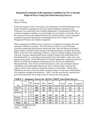
1. Integrated Evaluation of Revegetation Conditions for Five Colorado
Right-of-Ways Using Line-Point Intercept Surveys
Oct 12, 2014
Denise C Wilson
In July and August of 2014, Terra Logic, LLC performed a Line-Point Intercept survey
study of roadside revegetation on five past Colorado highway construction sites.
TerraLogic was contracted by the Colorado Department of Transportation (CDOT) to
evaluate revegetation conditions on selected right-of-way locations in Colorado. This is
the summary of the results obtained from the five forensic analyses, with an integrated
evaluation assessment and general recommendations for how to improve Best
Management Practices for roadside revegetation.
When comparing five different survey locations, it is important to recognize that each
represents a different ecosystem. Hwy 285 north of Conifer is a Lower Montane
ecosystem comprising mixed grasses, shrubs and forbs, with soils that are moderately
deep to shallow, formed in loamy material with high percentages of cobbles and stones.
TREX, at the University interchange in Denver, is near to remnant Tallgrass Prairie plots
with soils of humus, sand and small stones created by floods of the South Platte River.
East Berthoud Pass is a sub-alpine mixed-conifer forest with shallow, rocky soils, and a
short growing season. Powers Blvd north of Colorado Springs has a similar ecosystem to
TREX, but within the floodplain of Monument Creek, and it is near High Plains
Shortgrass Prairie. Hwy 50 east of Grand Junction is a cold, arid, semi-desert plateau
with shallow and impermeable alkaline clay rich in calcium sulfate, selenium and
sodium, which create conditions outside the tolerance of most plants. Despite these
differences, the survey scores are similar enough in range to reveal some commonalities
of revegetation strengths and limitations. Table 1 lists the years that the vegetation has
grown and summarizes the average scores for each site for each category.
TABLE 1 - Summary Scores for All Five CDOT Line-Point Surveys
Site
Yrs
Ref. Canopy
Cover
Bare
Ground
Basal
Cover Grazing
Overall
Health
Native
Abundance
Ecological
ContinuityGrowth Plot
Hwy 285 12 4 98% 0% 24% 1.2 3.4 3.4 3.2
TREX 13 4 83% 0% 8% 2.3 2.5 3.2 3.7
Berthoud 10 3-1,
3-2 82% 10% 17% 2.8 3.8 3.8 4.3
Powers 1 3 86% 4% 22% 1.6 4.2 4 4
Hwy 50 15 6 82% 16% 14% 2.2 2 2 1.8
*Mean 10.2 86% 6% 17% 2.0 3.2 3.3 3.4
*excludes Ref. (reference) plot
1-low 5-high
2. Mean Scores Evaluations for Five Locations
Canopy Cover, Bare Ground and Basal Cover Scores are Related
At each vertical data point, the survey captured a top canopy layer of plant material
observed; and also the lower layer of any plant material on the surface of the soil. A
significant amount, 86%, had foliar canopy cover, and further, only 6% was bare ground
on the soil surface. We can infer from the results that the ground was mostly covered by
revegetation at the CDOT locations surveyed. However, only 17% had basal cover; the
ground had leaf and litter coverage, but the surface of the soil had 17% growing plants
occupying space. A higher basal cover would mean more plants with wide basal leaves
and/or tufted plants with spreading rhizomatous roots, instead of stems arising from
taproots. This would provide more coverage and less competition for weeds, a major
vegetation roadside problem.
The highest score was on Hwy 285, which was 98% revegetated with 0% bare ground,
and the highest plant basal cover, (24%) of any of the survey sites. The weeds were
controlled at this site, and it proved to be excellently revegetated twelve years after
construction. The lowest scores were on Hwy 50, where the canopy cover was 82%, with
16% bare ground, and only 14% basal cover; however, many of the plants recorded were
weeds and introduced, non-native species. This exemplifies inadequate revegetation
because of the non-native nature of the plants. Berthoud Pass had similar scores for
cover, bare ground and basal coverage, but in contrast, most of the plants were natives;
with the caveat that mixed conifer forests can have a low percentage of foliar ground
cover due to high competition for sunlight and the accumulation of acidic conifer needles.
Thus, Berthoud showed a better revegetation result.
Qualitative Characteristics
The data sheets for each survey also included an observational judgment of four
qualitative characteristics, with a score of 1 – 5, low to high, for Grazing & Herbivory,
Overall Health, Native Plant Abundance, and Ecological Continuity.
Grazing & Herbivory
The mean for Grazing & Herbivory was 2, which indicates a below average defoliating or
clipping damage to plants. All of the plots showed below average grazing and herbivory.
TREX showed considerable defoliation from insects; this is an urban environment with
more concrete and warmth for insect reproduction. Damage was observed at Berthoud
Pass due to grazing deer, elk and moose, along with small mammals, but there was little
sign of insect grazing there.
Overall Health and Native Abundance
Overall Health mean was 3.2; about average, but the range of scores is wide, with Powers
Blvd scoring the highest, at 4.2, where plants were tall and healthy with few noxious
weeds, vs. Hwy 50 with a score of 2, where the healthiest plants appeared to be weeds
and kochia, an introduced species. Native Abundance followed closely with a mean
score of 3.3; similarly, Powers Blvd scored 4, and Hwy 50 a 2. These two categories tie
3. together; the observation of healthy native plants unencumbered by weeds leads to
similar scores for each category. Hwy 285, Powers and Berthoud were all high in native
plant diversity, with Berthoud Pass exhibiting the highest ratio of native plants.
Monocultures of introduced grass species were observed, such as smooth brome,
Kentucky bluegrass, timothy, and orchard grass, and these lowered the scores at several
transects. These non-native species were historically used for restoration because of the
high forage content for domesticated grazing animals, but are inappropriate for native
restoration.
Ecological Continuity
Ecological Continuity takes into consideration the health of the surrounding landscape;
the urban weedy survey sites were adjacent to urban weedy native sites. The mean is
actually a little higher, at 3.4, than Overall Health and Native Abundance, with better
than average continuity. Alas, weeds are abundant in urban environments, so the weedy
roadside begins to blend with the surrounding weedy habitat.
Powers Blvd Transect Plot One Year After Revegetation Efforts
Although Powers Blvd. survey data was collected only one year after revegetation, the
results are comparable to 10 -15 years of growth, at each of the four other sites surveyed.
This could be attributed to several possible factors:
• the level of detail, methodologies and management have improved over the past
15 years so that CDOT is better at revegetation;
• In 2014 the area received good rainfall;
• The first year's results are a good indicator of future right-of-way plant
regeneration;
• Hwy 50 is semi-desert and the saltbush take many years to develop, so it is not a
comparable site;
• Likewise, the elevation of Berthoud Pass’ plots was above 10,000 feet where,
because of short growing seasons, plants can take many years to establish, and so
was not comparable to Powers Blvd;
• Powers Blvd. construction reclamation was superior in some other unidentified
way to achieve as much plant growth in one year as the others in 10 to 15 years;
• Roadside revegetation cannot be expected to consistently exceed these averages
because of the inherent difficulties of vegetation reclamation;
• Roadside maintenance over time introduces pollutants, and exotic plants get
introduced which effect the overall health of roadside vegetation, causing
degradation over time;
• The survey sample is too small;
• Other unidentified factors.
Common Treatments and Amendments are Working Well
The results of these diverse transect plots suggest that CDOT is doing a good job with
right-of-way revegetation and should maintain and refine their Best Management
Practices for reclamations. In general, soil amendments which improve the quality of the
soil produce better vegetation. Specifically, the site’s soil needs to be analyzed and
4. matched, as in the case of Hwy 50, where the native soils have unusual characteristics,
and creating better soil just makes fertile ground for weeds and non-native plants.
Mulching and mulch tackifier are necessary to keep seeds in place and take advantage of
precipitation on sites that are not irrigated. Adding compost to the topsoil mix elevates
the organic matter content, contributes nutrients and improves moisture retention.
Looking at Revegetation Success Relative to the Surrounding Natural Landscape
If the goal is to produce a roadside of native, weed free vegetation, then the plant species
of the immediate environments should be examined. Each of the five locations had a
native reference, or background plot. It was often difficult to locate a reference plot
contiguous to the right-of-way being plotted since most of the sites were populated and
well developed and had altered plant species as a result of past ranching or farming.
These scores below in Table 2 list the four characteristics relative to each location’s
native plot, plus a group mean for each characteristic. A general viewing of these figures
shows much more variation between the sites than the summary scores in Table 1. This
is because each site is being compared to an ideal local native plot.
Table 2 – Summary Scores for Relative Health Evaluations and Percent of Cover
Site Grazing Overall
Health
Native
Abundance
Ecological
Continuity
Percent
Seedmix
Observed
Hwy 285 60% 85% 68% 64% 35%
TREX 117% 83% 63% 73% 31%
Berthoud
Pass 81% 85% 75% 87% 47%
Powers
Blvd 80% 105% 80% 80% 28%
Hwy 50 55% 40% 40% 36% 16%
*Mean 79% 80% 65% 68% 31%
Again, it is informative to examine the high and low scores, and account for success and
failure.
Grazing
The low score is on Hwy 50 with a score of 55%, and TREX with a score of 117%. The
survey team observed a high level of defoliation and insect nests on the plants at TREX.
A low score in this characteristic indicates a positive condition of low grazing or
herbivory compared to the native adjacent plot. Small mammals were observed by the
team at both sites.
Overall Health
The low is Hwy 50, with 40%, and the high is Powers Blvd with 105%. The challenges
of clay soils, salinity and alkalinity along Hwy 50 have already been noted. Powers Blvd
had received soils superior to the adjacent native plot, which may have accounted for
5. better plant health in the reclaimed area than the contiguous native plot. The other three
locations show good overall plant health.
Native Abundance
The low score is Hwy 50, with 40%; the high is Powers Blvd scoring 80%, followed by
Berthoud Pass with 75%. Hwy 50 plant coverage was comprised mainly of weeds,
whereas Powers Blvd and Berthoud Pass plant coverage was a diverse mix of native
species. Seedmix establishment and native plant colonization were very good at both of
these sites because of improved soil amendments during reclamation.
Ecological Continuity
The low score is 36% for Hwy 50, and the high is 87% for Berthoud Pass. Hwy 50’s
roadside revegetation of weedy species appeared very different from the indigenous mat
saltbush community. Berthoud Pass roadside revegetation appeared very similar to the
native plot, comprising many diverse plant species.
Percent Seedmix Observed
This category, not originally in the scope of work, was added to quantify the level of
success of the seedmix plant species’growth. Again, Hwy 50 is the low score, with 16%
of the seedmix species observed, and Berthoud Pass is the highest score, with 47%
observed. Hwy 50 seedmix could have included a species list better matched to the
natural environment, particularly the grasses, although the chosen shrub species were
correct. Berthoud Pass seedmix was composed of several species native to the area, and
this helped plant establishment, health, and overall revegetation.
Recommendations
• A survey of existing vegetation and percent cover should be conducted prior to
commencing construction. This data should determine the components of the
seedmix. An observational walk-through and compilation of plant species at an
adjacent native site will result in a list long enough to be able to cull 8-14 plant
species which grow naturally on site from which the seedmix of available species
and the quantities needed can be derived.
• The reclamation seedmix should contain native plant species only, no introduced
species.
• Grass species might be considered exclusively in the first year, followed by an
application of herbicides to eliminate weeds, followed by a seeding of native
grasses and forbs in the second year.
• Seedmix should contain at least one sterile species (such as oats used at Powers or
Regreen used at Hwy 50) to quickly establish ground cover; or a one-season crop
species to provide coverage by the end of the first season. This controls early
weeds and exotic species the following spring. Ground coverage is the goal.
• Additionally, the seedmix needs a plant species, such as slender wheatgrass
(Elymus trachycaulus) for montane, sub-alpine and alpine habitats, which is early
successional; these grasses establish quickly and typically flourish for 2-3 years
while native plant seeds colonize from the surrounding area. The NRCS
6. document, Early Successional Habitat, can be used as a resource reference for
development of Best Management Practices.
• Best Management Practices, such as retaining and redistributing topsoil, must be
maintained. This topsoil should be disturbed as little as possible and scrapped
mechanically to preserve the soil horizon.
• Detritus such as chipped trees and brush, grounded sticks and logs, leaves and
dead plant matter can be used in the top soil layer as these encourage the
development of mycorrhizal fungi. Mycorrhizal inoculation should be tested for
viability and cost considerations.
• Seedmix needs to be diverse enough to encompass plant species with different
basal growth forms and different root systems. Select for basal growth rosettes,
as well as robust stems; for roots fibrous and rhizomatous vs. a long taproot. This
diversity provides vegetation cover in different conditions. This provides some
insurance against extreme weather conditions such as drought or flooding due to
changing climates.
.
References
Early Successional Habitat, NRCS; 2007;
http://www.nrcs.usda.gov/Internet/FSE_DOCUMENTS/nrcs143_010001.pdf
7. document, Early Successional Habitat, can be used as a resource reference for
development of Best Management Practices.
• Best Management Practices, such as retaining and redistributing topsoil, must be
maintained. This topsoil should be disturbed as little as possible and scrapped
mechanically to preserve the soil horizon.
• Detritus such as chipped trees and brush, grounded sticks and logs, leaves and
dead plant matter can be used in the top soil layer as these encourage the
development of mycorrhizal fungi. Mycorrhizal inoculation should be tested for
viability and cost considerations.
• Seedmix needs to be diverse enough to encompass plant species with different
basal growth forms and different root systems. Select for basal growth rosettes,
as well as robust stems; for roots fibrous and rhizomatous vs. a long taproot. This
diversity provides vegetation cover in different conditions. This provides some
insurance against extreme weather conditions such as drought or flooding due to
changing climates.
.
References
Early Successional Habitat, NRCS; 2007;
http://www.nrcs.usda.gov/Internet/FSE_DOCUMENTS/nrcs143_010001.pdf