Srinagar seminar
•
6 likes•1,857 views

Srinagar is the largest city in Jammu and Kashmir with a population of over 1 million. It has a rich cultural heritage seen in its traditions like Bhand Pather folk theatre and Sufiana music. The city is located on the banks of the Jhelum River and has a mild summer climate. Major landmarks include Dal Lake and various Mughal gardens. However, rapid urbanization has created challenges around issues like sewerage, drainage, housing and water supply. There is a need for improved urban planning to manage growth in a sustainable manner while preserving Srinagar's cultural heritage and natural environment.

Recommended
Recommended
More Related Content
What's hot
What's hot (20)
Viewers also liked
Viewers also liked (8)
Similar to Srinagar seminar
Similar to Srinagar seminar (20)
Recently uploaded
Recently uploaded (20)
Srinagar seminar
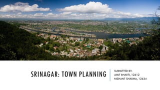
- 1. SRINAGAR: TOWN PLANNING SUBMITTED BY: AMIT BHARTI, 12612 NISHANT SHARMA, 12634
- 3. TRADITIONS OF SRINAGAR Like the state of Jammu and Kashmir, Srinagar too has a distinctive blend of cultural heritage. Holy places in and around the city depict the historical cultural and religious diversity of the city as well as the Kashmir valley. While the Kashmir has been the highest learning centre of Sanskrit and Persian where early Indo-Aryanic civilization has originated and flourshed, it has also been embracing point of advent of Islam bringing its fold finest traditions of Persian civilization, tolerance, brotherhood and sacrifice. Some of the popular performing traditions of Srinagar are as follows :- Bhand Pather : It is a traditional folk theatre style combination of play and dance in a satirical style where social traditions , evils are depicted and performed in various social and cultural functions. Bhand Jashan is performed by a group of 10 to 15 artists in their traditional style accompanied by light music for the entertainment of people.
- 4. TRADITIONS OF SRINAGAR Chakri : It is most popular form of Kashmiri folk music. It has some resemblance with chakra of mountaineous regions of Uttar Pradesh. Normally Garaha, Sarangi, Rabab were the musical instruments used in the past. But now the harmonium too has made its way in its presentation. Sufiana Music : Sofians musiqui came to Kashmir from Iran in the 15th century. Over the years it has established itself as the classical music form of Kashmir and has incorporated a number of Indian Ragas in its body. Hafiz Nagma in fact, used to be part of sofiana music. The instruments used in this form are Santoor, Sitar, Kashmiri Saz, Wasool or Tabala. In Hafiz Nagma a dancer is a female while her accompanists on various instruments are males. Hafiza moves her feet on musical notes.
- 5. OVERVIEW Indulgent houseboats, historic gardens, distinctive Kashmiri wooden mosques and a mild summer climate combine to make Srinagar one of India’s top domestic tourist attractions. Srinagar’s three main areas converge around Dalgate, where the south western nose of Dal Lake passes through a lock gate. Northwest lies the Old City, fascinatingly chaotic in normal times but largely out-of-bounds during curfews. The busy commercial centre is southwest around Lal Chowk. The city’s greatest drawcard is mesmerisingly placid Dal Lake, which stretches in a south western channel towards the city centre, paralleled by the hotel-lined Boulevard from which a colourful array of houseboats form a particularly colourful scene. This area usually remains free of trouble even duing the worst disturbances, as do the famous Mughal gardens, strung out over several kilometres further east around the lake. For a visual portrait of Dal Lake life, watch the prize-winning 2012 movie Valley of Saints.
- 6. INTRODUCTION Srinagar is the first Metropolis and fastest growing city of Jammu and Kashmir State. It is located in the heart of the Valley on both banks of River Jehlum. It has rich historical past with bountiful natural heritage. It is also the Summer Capital and the major tourist destination centre of the State. The locational centrality has given it advantageous position in the settlement system. The population of Srinagar Urban Agglomeration was 4.82 lakhs in 1971 6.06 lakhs 1981 which has increased to 1.11 million in 2001. It has a rich and variegated history which reflects that the City of Srinagar has been in existence and functioning as a major trade and tourist centre since ages. Its connectivity through a well connected road network system has made it centre for administrative, trade and commerce, major socio-cultural infrastructural facilities for whole of the Valley.
- 7. CITY NOW The present study is for Srinagar city, once called as “Paradise on Earth”, but now the greed of man has transformed it in to a conflict zone. The study area lies between 33°59'14''N and 34°12'37''N latitude and 74°41'06''E and 74°57'27''E longitude, is summer capital of the state of Jammu and Kashmir. The city is located on both sides of the River Jhelum, locally called Vyeth in Kashmir .The study area spreads between the plains of vale of Kashmir along the river Jhelum. The general relief of the study area is 1 580 m above mean sea level. The general terrain of the study area is moderate and represents hill topography. The population of Srinagar city in 1951 was 255 679 which increased up to 952 324 in 2001, recording a growth of +51.06 percent (the projected population for 2011 is about 1.5 million). As of 2011 census, Srinagar city's population was 1,192,792 and Srinagar urban agglomeration had 1,273,312 population. Both the city and the urban agglomeration has average literacy rate of approximately 71%, whereas the national average is 74.04%. The entire hill area is for the last many years are in tur-moil with political, economic and social conflicts. At the same time, the city has also witnessed urban forces acting to transform the city landscape.
- 9. LOCATION OF WATER BODIES
- 10. CHALLENGES AND PLANNING The problems of Srinagar City and its environs constituting the metropolitan area are becoming more and more critical with the increase in population and deterioration in existing level of services. Sewerage Drainage Traffic and Transportation Housing for urban poor Conservation of natural or cultural heritage Acute shortage of potable water supply Increased pace of urbanization PLANNING The finances : JNNURM Rs.4206.94 Crores constituting Rs.3783.48 Crores for Submission – I and Rs.423.46 Crores for Submission –II. Possible resource recovery sources :Municipal Authorities and various stake holders.
- 11. CLIMATE: The city enjoys a sub-Mediterranean type climate with severe winters and moderate summers associated with relatively higher humidity throughout the year varying from 78 per cent to 91 per cent (minimum 45 per cent). Normally the temperature ranges between 29C to 34C, occasionally touching the highest 39 C in summer and in winter temperature varies from 5 C to 10 C. About the wind direction, northerly, north-westerly 5 to 10 kms per hour. However, interspersed hillocks and water bodies in and south-westerly winds are more predominant with an with an average wind velocity of 2 to 5 and around the city produce considerable micro-level variation in direction and speed of winds. The severe winter and moderate summer climate conditions are suited for low rise high density development of residential areas. The microclimatic variation also play a very important role in orientation and design of buildings. Precipitation in the city is almost spread over throughout the year varying from 1.5 to 21 centimeters Srinagar city stands on the valley floor with some expansion of urban activities on hill slopes, lowlying areas and Karewas.
- 12. GEOLOGY Geologically, Kashmir Valley has its own importance. It is said that the Valley has undergone many changes in its geological times and falls within the geological history of mountain building movements in the country The Valley floor which form part of the city is filled with alluvium and fluvio-laustrine deposits cover nearly 90 per cent of city area. The present water bodies of Dal, Nagin, Manasbal and other wet areas are believed to be remnant of the “Satisar Lake” Being located in mountain building movement area of the country seismic phenomenon area are located in the south and south west of the city, the evidences of seismic activity have been seen in village bringing in Tehsil Chadora, District Badgam in 1998.
- 13. DRAINAGE The natural drainage of the city is provided by three main rivers which are joined by small rivulets and canals. River Jhelum which enters Srinagar in the south-east flows through the city in serpentine manner with a number of meanders, leaving it in west after dividing city into two parts. It is around this river that the city has initially evolved and prospered, as a result Kashmir is often referred as “Water Civilization”. The drainage water of old city including waste water of urbanized areas of the city is carried away by different canals/khuls which are connected with river Jhelum, Dal Lake, Nagin Lake, Brari Nambal and Khushal Sar. These khuls were initially used as communication lines and their waters were also used for irrigation, drinking and other domestic purposes.
- 14. HISTORICAL DEVELOPMENT The present day Srinagar City is the collection of period pieces and long period of time with rich and variegated history. The independent Hindu and the Buddhist rule of Srinagar lasted until the 14th century when the Kashmir valley, including the city, came under the control of the several Muslim rulers, including the Mughals. Though the city has served as the capital of Kashmir throughout the ages. The present day city has grown as a blend of number of ancient sites which had served as capital cities from time to time for various rulers. The city expansion took place without any planned directives which resulted unplanned, haphazard development of residential areas, congestion, with acute problems of drainage, irregular narrow lanes and streets littered with filth and dirt. River Jhelum the main source of water and communication channel was polluted due to slush from houses draining directly into it. This resulted as a great threat to the public health creating unhygienic and in-sanitary conditions. In the later art of the Dogra rule (1900 A.D) Srinagar recorded some developmental and construction activities.
- 15. The residency with its grotesque/unnatural gardens,a number of educational institutions, first intermediate College (S.P. College, 1938) and Library were established. Potable water supply and modern means of transportation were also made available for the first time in the city which necessitated the construction of metalled road and accelerated the process of development in the city. The opening of cart road over Banihal pass and 196 km long Jhelum Valley cart road connecting Srinagar with rail head at Rawalpandi (now in Pakistan) were also constructed. Silk Factory and Woollen Mills also were established (1921-31), besides this, medical facilities and other public utilities and services were also provided. It was also during the Dogra rule in 1886 that first Municpal Act was passed. In 1913 a new Act introducing an elected element in constitution of local bodies of Srinagar was enacted. All these efforts geared up the development activities during Dogra rule which were made possible through the courtesy of Britishers proved of significant value because they not only helped in eradicating the epidemic diseases but also solved to a larger extent the socio-economic problems of the city.
- 16. During the modern period (1947-1997) the city recorded more or less an uninterrupted growth through successive and concerted efforts after launching Five Year Plans which marked a beginning of the Planning era in the State. The development of most of the administrative, education and medical institutions and residential colonies in and around the commercial hub (Lal Chowk) changed the form and morphological structure of the city Besides this, the impact of increased trade activities and tourism has brought significant transformation in the physical and socio-economic structure of city. Srinagar which initially was an administrative-cum-religious centre, has now been transformed into multi-functional city.
- 17. TREND OF GROWTH
- 18. HERITAGE SITES Special features in the form of places of scenic beauty, buildings and monuments attributed to the invigorating surroundings and important events occurring in city‟s socio-political life distinguish the city from the rest. Because of the rich historical past and bountiful natural setting, Srinagar is endowed with a number of such heritage areas which lend the city a place of pride. These need to be preserved and improved. Some of the heritage elements/sites are as under: i. Places of Archaeological Importance at Harwan, Parhaspur and Burzhama. ii. Hariparbath Fort, Pari Mahal, Budshah Tomb, Mughal Gardens. iii. Major Religious Places like Jamia Masjid, Hazratbal Shrine, Imambara, Dastgeer Sahib, Chatipadshahi Gurdawara, Khankahi Moula. iv. Natural Heritage Elements like Lakes, Water Bodies, Rivers, Canals and the mountainous landscape including Kohimaran Hill, Kohi Sulaiman Hill, Zabarwan mountains.
- 19. THRESHOLD AND POTENTIAL A sizeable portion of the city is flood prone and low-lying. These areas are not suited for city expansion and development. Some of the areas e.g Mahjoor Nagar, Soiteng etc. have experienced widespread residential expansion and face problem of frequent occurrence of floods, drainage, sewerage, poor road network and inadequate urban amenities. Inner city which has grown over the centuries in congested manner pose serious challenges. The whole inner city is almost built-up in extremely crowded pattern with narrow lanes and bye-lanes, poor drainage and inadequate amenities and facilities. In older areas dilapidation and poor maintenance have also added new dimensions in the city development. Disposition of graveyards and religious places along the major arteries pose serious constraints in harmonious development of the city. Ownership of land in Srinagar is predominantly in private hands. This is likely to generate tentacles in the implementation of development proposals. Therefore, local city authorities need to generate more finances and strictly enforce the development regulations. Lack of appropriate drainage and sewerage facilities in the City. At present about 55 per cent of the city‟s population is deprived of such facilities. In the absence of these facilities most of the domestic wastes are directly draining into lakes, rivers, canals and other wet lands. This has not only generated unhealthy living condition but also act as a deterrent in the development of the city.
- 20. POPULATION GROWTH 1901 1,22,618 - 1911 1,26,344 + 2.9 1921 1,41,735 + 11.4 1931 1,73,873 + 20.16 1941 2,03,787 + 17.92 1951 2,46,522 + 17.05 1961 2,85,257 + 14.56 1971 4,57,511 + 46.38 1981 5,94,825 + 26.10 1981 6,06,002 + 27.92 2001 11,10,467 + 41.62 YEAR POPULATION GROWTH RATE
- 21. POPULATION PROJECTIONS 2021 2350000 Year Population 1971 457511 1981 606002 2001 1110467 2006 1318886 2011 1566423 2021 2350000
- 22. EXISTING LAND USE PATTERN
- 23. TREND OF GROWTH
- 24. LAND USE CHANGE
- 25. LAND USE COVER: 1971
- 26. LAND USE COVER: 2008
- 28. TRANSFORMATION OF WATER BODIES
- 31. WHAT WE DID? : PLANNING EFFORTS The earliest settlement seems to have originated owing to strategic reasons and geo-physical factors including presence of water bodies, non-availability of land for development, poor connectivity and accessibility, which resulted into inorganic structure of old city with irregular road network and congested development. The new commercial core (CBD) Lal Chawk which is a fair example of civic design is a result of conscious planning during British regime who ruled Kashmir indirectly. During this regime Srinagar had a touch of conscious planning although in parts. Oberia Palace, Shargari, Amar Singh College, S.P.College and other edifices nearby are the result of these efforts. But it seems that apart from these scat efforts, no comprehensive efforts for development or improvement of the city were made till the preparation of Master Plan in 1971. The Master Plan 1971-91 was a well conceived plan with coherent policy directives and proposals, but the tardy implementation of the proposal contained in plan and lack of appropriate technical know-how with local urban development agencies in the city did not only defeat basic objectives of Master Plan but has also generated inhuman living conditions which are irreprehensible. Second Master Plan for Srinagar Metropolitan Area has been formulated for a plan period of 20 years (2000 – 2021). The Plan contains detailed guidelines to regulate growth and development 17 during next twenty years and takes care of infrastructural requirements and services during the plan period and requirements for Metropolitan Area.
- 32. LAND USE PATTERN AND SEWERAGE DISPOSAL
- 33. SW & POOR HOUSING
- 34. URBAN LIVING : POOR QUALITY
- 35. URBAN LIVING & MESSY TRANSPORT SYSTEM
- 40. PROPOSED TRAFFIC AND TRANSPORT VEINS
- 41. PROPOSED LAND USE PATTERN.
- 42. EVACUATION PLAN
- 44. THANK YOU.