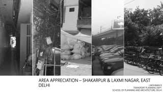
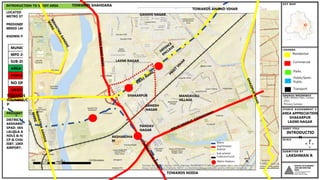
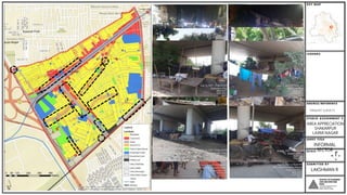
SEE THIS PPT IN SLIDESHOW MODE
About project
This project was an individual studio project named Area Appreciaton.
The main objective was to learn how to look and evaluate an area from a planners perspective.
So we were asked to select an area of about 1 Sqkm near our place of stay and appreciate several aspects related to spatial planning, quality of life etc.
I have selected Shakarpur and a part of Laxmi Nagar. Had a very hectic time but it was all fun and worth it!
Area Appreciation - Ward 20 & 22, Muzaffarpur, BiharMdOsamaZamani
Detailed presentation about a neighbourhood in a small organically developed town in Bihar. Talks about the present conditions in the area along with the vulnerabilities and conclusion.
Chennai the fourth largest metropolis in India. Chennai Metropolitan Area (CMA) extends over 1189 sq.km.and comprises of
Chennai Corporation,
16 Municipalities,
20 Town Panchayats and
214 villages covered in 10 Panchayats Unions
It encompasses the Chennai District (176 sq.km.), part of Thiruvallur District (637 sq.km.) and a part of Kancheepuram District (376 sq.km.).
Vasna, a municipal ward under Ahmedabad Municipal Corporation (AMC) was taken for study for Area Planning Studio -2013. The aim was to identify the key issues, opportunities and inherent development potential of the ward and to prepare a ward plan through a specific vision which could mitigate the current problems plaguing the ward and promote balanced development and thus serve the present and future population of the ward as well as the city.
Neighborhood planning in capital city of chandigarh an appraisal JIT KUMAR GUPTA
Paper is an attempt to critically and objectively evaluate the application of Neighborhood planning in capital city of chandigarh along with its success and failure
presentation based on Land Acquisition act and Land pooling in India. PPT is helpful for Urban Planning Students. discussed various land pooling models in India.
Review of Development Plans/ Master Plans of selected cities of India.KARTHICK KRISHNA
This is an academic assignment done for the purpose to draft a master plan/ development plan. This helps us to identify the concept and context of the various plans and its development proposals applicability and replicability.
M.Plan First Semester Integrated Brochure - School of Planning and ArchitectureLakshman R
This is basically what we do in M.Plan 1st Semester SPA Delhi. All streams (Regional Planning, Transport, Housing, Environment and Urban Planning) are integrated for the foundation semester in town planning after which each steam is separated and a specialization is introduced in semester 2, 3 and 4. This is also a fun time where we learn a lot of basics, meet people of all other streams and build networks.
Master Plan for Delhi–with the Perspective for the Year 2021
Here is the official Delhi Master Plan 2021. It is being uploaded by FSGOWS for Public viewing and downloading.
This presentation covers the Urban Planning stages of Bhubaneswar, one of India's first modern cities along with Jamshedpur and Chandigarh. This city, the current capital of the coastal state of Odisha, was planned the German architect and urban planner, Otto Konigsberger, who also happens to be the author of 'Manual of Tropical Housing and Building.'
REGIONAL PLAN: A CASE OF MUMBAI METROPOLITAN REGIONYash Shah
Regional planning deals with the efficient placement of land-use activities, infrastructure, and settlement growth across a larger area of land than an individual city or town. Regional planning is a sub-field of urban planning as it relates land use practices on a broader scale. It also includes formulating laws that will guide the efficient planning and management of such said regions.
Regions require various land uses; protection of farmland, cities, industrial space, transportation hubs and infrastructure, military bases, and wilderness. Regional planning is the science of efficient placement of infrastructure and zoning for the sustainable growth of a region. Advocates for regional planning such as new urbanist Peter Calthorpe, promote the approach because it can address region-wide environmental, social, and economic issues which may necessarily require a regional focus.
A ‘region’ in planning terms can be administrative or at least partially functional, and is likely to include a network of settlements and character areas. In most European countries, regional and national plans are ‘spatial’ directing certain levels of development to specific cities and towns in order to support and manage the region depending on specific needs, for example supporting or resisting polycentrism.
The Mumbai Metropolitan Planning Committee (MMPC) was formed under the provisions of the Maharashtra Metropolitan Planning Committee Act 1999 and has been entrusted with the task of preparing a Regional Plan for the Mumbai Metropolitan Area with help from MMRDA. Currently, the Regional Plan 1996 is in operation which was prepared by the Mumbai Metropolitan Region Development Authority (MMRDA) and sanctioned in 1999. The MMRDA was established under the MMRDA Act, 1974 and undertook the revision of the First regional plan prepared by the Regional Planning Board and sanctioned in 1973, under the provisions of the MR& TP Act, 1966.
Appreciation of an Urban Neighbourhood at Dehradun UttarakahndAnoushka Tyagi
The area selected for the study is the area between Prince chowk to Darshan Laal chowk including the Dhamawalla Mohalla & Dalanwala. The Land-use, reasons for site selection, Mapping of physical attributes to understand the exiting planning on the site, urban policies and issues and challenges faced in the urban infrastructure are accessed along with their remedial measures.
The motivation of this study is to explore about Transit Oriented Development (TOD), its parameters and principles. This dissertation includes case studies of areas that show the benefits of TOD and how it is making public transportation feasible near stations and thereby reducing traffic jam problems.
Site Planning Studio 1st Semester M.Plan SPADLakshman R
We could have done a better job on some aspects such as Infrastructure and the layout itself. But being an online mode of study and some lack of our efforts and guidance, we did just this much.
This site is in Dwaraka near the Pacific Mall. It was an interesting case where the site is fully covered with trees. Once cant go beyond 20 meters into the site. So we somehow managed with the GIS analysis of contours and google earth imagery.
It was planned for a population of 10k. If i have the time, shall share some improved sheets of the same (Now that we have learned from some of the mistakes) (like Storm water drain design - to an extent, some road intersections, Entry and Exit points etc.
Site planning is the initial step to site designing. Good understating about the site is foundation to planning and designing. A well designed site analysis opens a path to site planning and designing.
THIS FILE IS ABOUT THE DETAIL STUDY OF THE WARD NO 49 OF THE BHOPAL ,INDIA. IT TALKS ABOUT THE LOCATION OF WARD, LANDMARKS IN THE WARD,STASTICS,AND THE ISSUES IN THE WARD AND ALSO SOME SOLUTIONS REGARDING IT.
Presentation made by Mr Dilip Brahmbhatt, Sr Manager, GIDB, Gujarat at the India LAC Investment Conclave. The conclave is being organised by FICCI in New Delhi. More details at indialacconclave.com
A TRUST BUILT OVER THE YEARS. | BEST REAL ESTATE COMPANY IN PATNA
We are a renowned Construction Company and top builders in Patna, Bihar. We are specialized in the construction of residential apartments and offer flats in Patna for sale at affordable prices. We are one of the Top Real Estate Developers in Patna and have been awarded many times as Best Construction Company in Patna.
Similar to Area Appreciation Studio - 2021 - SPAD M.Plan (20)
Expert Accessory Dwelling Unit (ADU) Drafting ServicesResDraft
Whether you’re looking to create a guest house, a rental unit, or a private retreat, our experienced team will design a space that complements your existing home and maximizes your investment. We provide personalized, comprehensive expert accessory dwelling unit (ADU)drafting solutions tailored to your needs, ensuring a seamless process from concept to completion.
White wonder, Work developed by Eva TschoppMansi Shah
White Wonder by Eva Tschopp
A tale about our culture around the use of fertilizers and pesticides visiting small farms around Ahmedabad in Matar and Shilaj.
Hello everyone! I am thrilled to present my latest portfolio on LinkedIn, marking the culmination of my architectural journey thus far. Over the span of five years, I've been fortunate to acquire a wealth of knowledge under the guidance of esteemed professors and industry mentors. From rigorous academic pursuits to practical engagements, each experience has contributed to my growth and refinement as an architecture student. This portfolio not only showcases my projects but also underscores my attention to detail and to innovative architecture as a profession.
You could be a professional graphic designer and still make mistakes. There is always the possibility of human error. On the other hand if you’re not a designer, the chances of making some common graphic design mistakes are even higher. Because you don’t know what you don’t know. That’s where this blog comes in. To make your job easier and help you create better designs, we have put together a list of common graphic design mistakes that you need to avoid.
Book Formatting: Quality Control Checks for DesignersConfidence Ago
This presentation was made to help designers who work in publishing houses or format books for printing ensure quality.
Quality control is vital to every industry. This is why every department in a company need create a method they use in ensuring quality. This, perhaps, will not only improve the quality of products and bring errors to the barest minimum, but take it to a near perfect finish.
It is beyond a moot point that a good book will somewhat be judged by its cover, but the content of the book remains king. No matter how beautiful the cover, if the quality of writing or presentation is off, that will be a reason for readers not to come back to the book or recommend it.
So, this presentation points designers to some important things that may be missed by an editor that they could eventually discover and call the attention of the editor.
Dive into the innovative world of smart garages with our insightful presentation, "Exploring the Future of Smart Garages." This comprehensive guide covers the latest advancements in garage technology, including automated systems, smart security features, energy efficiency solutions, and seamless integration with smart home ecosystems. Learn how these technologies are transforming traditional garages into high-tech, efficient spaces that enhance convenience, safety, and sustainability.
Ideal for homeowners, tech enthusiasts, and industry professionals, this presentation provides valuable insights into the trends, benefits, and future developments in smart garage technology. Stay ahead of the curve with our expert analysis and practical tips on implementing smart garage solutions.
1. AREA APPRECIATION – SHAKARPUR & LAXMI NAGAR, EAST
DELHI LAKSHMAN R
TRANSPORT PLANNING DEPT.
SCHOOL OF PLANNING AND ARCHITECTURE, DELHI
2. Note for the reader
SEE THIS PPT IN SLIDESHOW MODE
About project
This project was an individual studio project
The main objective was to learn how to look and evaluate an area from a planners perspective.
So we were asked to select an area of about 1 Sqkm near our place of stay and appreciate several aspects related to
spatial planning, quality of life etc.
I have selected Shakarpur and a part of Laxmi Nagar. Had a very hectic time but it was all fun and worth it!
3. Residential
Commercial
Parks
Public/Semi-
Public
Transport
Delhi Master Plan, Census
2011,
Primary Surveys
AREA APPRECIATION
SHAKARPUR
LAXMI NAGAR
INTRODUCTIO
N
LAKSHMAN R
INTRODUCTION TO STUDY AREA
LOCATED IN EAST DELHI – NEAR LAXMI NAGAR
METRO STATION (VAISHALI BOUND BLUE LINE)
PREDOMINANT LANDUSE: RESIDENTIAL AND
MIXED LANDUSE
KNOWN FOR IAS & CA COACHING INSTITUTES
MUNICIPALITY EDMC
MPD 2021 ZONE E (87 SQ.KM)
SUB-ZONE E-12
AREA OF SITE 1.36 SQ.KM
POPULATION 79028
NO OF HH 17,561
GROSS 577 PPH
NET DENSITY 1340 PPH
PROXIMITY
DISTRICT CENTRE: 1KM
AKSHARDHAM: 2.5KM
SPAD: 4KM
LALQILA & INDIA GATE: 5KM
NDLS & NIZAMUDDIN: 6KM
CP & CHANDNI CHOWK: 7KM
ISBT: 10KM
AIRPORT: 20KM
6 KM
5 KM
4 KM
3 KM
2KM
Sub-arterial
Collector/Local
Metro
Arterial
Metro Stations
LAXMI NAGAR
SHAKARPUR
GANESH
NAGAR
GANDHI NAGAR
MANDAVALI
VILLAGE
PANDAV
NAGAR
TOWARDS SHAHDARA
TOWARDS
ITO/NDLS/C
P
TOWARDS NOIDA
TOWARDS ANAND VIHAR
AKSHARDHA
M
Expressways
4. LAND USE
LAKSHMAN R
Primary Surveys
Google Maps
Delhi Revenue Maps
6.55%
2.74%
8.20% 0.70%
4.10%
8.18%
43.04%
25.39%
0.42%
0.50%
0.17%
LANDUSE AREA (HA) PERCENTAGE
RESIDENTIAL 58.933 43.04%
MIXED (R+C) 11.2341 8.20%
COMMERCIAL 8.9745 6.55%
PARKS & OPEN SPACES 5.6089 4.10%
PUBLIC/SEMI-PUBLIC 11.2044 8.18%
ROADS 34.7721 25.39%
PARKING LOTS 0.9593 0.70%
UTILITY (ELECTRICITY) 0.0018 0.001%
UTILITY (SEWERAGE) 0.0057 0.004%
UTILITY (SWM) 0.577 0.42%
UTILITY (WATER SUPPLY) 0.6863 0.50%
VACANT 0.2283 0.17%
GOVERNMENT LAND 3.7484 2.74%
TOTAL 136.9368 100.00%
COMMERCIAL CHARACTER
IAS AND CA INSTITUTES ON VIKAS MARG EATERIES
V3S MALL VEER SAWARKAR BLOCK SHAKARPUR MARKET
CHAYAN JAIN MARG WHOLESALE PAPER MARTS RECYLING
PUBLIC/SEMI-PUBLIC LANDUSE
INSTITUTES ON PATPARGANJ ROAD
DDA OFFICE, BSES OFFICE AND SCHOOLS IN SCHOOL BLOCK,
SHAKARPUR
21 TEMPLES, 2 COMMUNITY HALLS AND 1 VETERINARY HOSPITAL IN SITE
AREA APPRECIATION
SHAKARPUR
LAXMI NAGAR
Circle Rate:
Area under Category F, G
F: 56650/Sqm (5300/Sft)
G: 46200/Sqm (4400/Sft)
Market Value
10000/Sft -20000/Sft
Rental Value
3000-10000/PG
10k – 2BHK
15K - 18K- 3BHK
Shop – 10ft x10ft- 15K – 30K
5. HISTORY
LAKSHMAN R
AREA APPRECIATION
SHAKARPUR
LAXMI NAGAR
1958 ELU
1962 PLU
1965 SATELLITE IMAGERY
Vacant land as per 1958 ELU
1962 PLU marks the area as
residential while part of school
block is reserved as green belt.
However, no bridge is planned at
this stage
1965 Satellite Imagery shows no signs of development.
Shakarpur Khas Village is the only built up area (about 20-30
Dwellings are visible). Vikas Marg Bridge has been planned as
a part of the road is seen on the eastern bank
DDA OFFICE
NEHRU
ENCLAVE
UACs
TODAY
DISPENSARY NOT DEVELOPED BUT IS
USED AS A MEDS PROCUREMENT
OFFICE
2021 PLU
2004 2010
2015 CURRENT
Fully built before start of 21st Century
Metro Connectivity established in 2008
2001
PLU
1973 SATELLITE IMAGERY
Bridge has been constructed in late 60s and area begins to
develop into a residential area owing to access and low land
values. First settlers are Govt Employees looking to build
homes with less investment. Green belt is not encroached as
seen:
Several illegal layouts were developed
The village area slowly changed character
and became densely populated as the
buildings were exempt from building by laws
DDA lands were also encroached and after a
failed attempt at demolition, the illegal
layouts and encroached properties were
regularized (Hence known as Unauthorized
Regularized Colonies)
Subsequently, the green belt (In school block
viz. Nehru Enclave) and several more DDA
lands near Railway line were encroached.
For eg. Nehru enclave – One of the four
UACs as per 2041 MPD is under process of
being awarded land ownership documents.
(started in 2014)
1992
SATELLITE
IMAGERY
500m
250
125 375
Primary Surveys
Google Maps
USGS and EDMC
6. DEVELOPMENT
TYPOLOGY
LAKSHMAN R
MPD 2021
MPD 2001
Primary Surveys
Category Cap on Density
Slum/EWS 600 DU/Ha
30-40 Sq.m 500 DU/Ha
40-80 Sq.m 250 DU/Ha
> 80 Sq.m 175 DU/Ha
Plot Size GC (%) FAR DUs S.BACK
<32 Sq.m 90 350 3 0
32-50 Sq.m 90 350 3 0
50-100 Sq.m 90 350 4 0
100-250 Sq.m 75/100 300/350 4 3M - F
Parking: 1 ECS/100Sq.m
AREA SIZE FAR AVG DU/Ha PARKING S.BACK
1 1.7Ha 369 290
2 3.6Ha 445 355
3 1Ha 386 310
URBAN VILLAGE AREA
SAKARPUR KHAS
AREA 3: 1Ha
TOTAL DUs: 310
3-4 M Roads
BALCONIES PROJECT ONTO ROADS
PLOTS Nos PKNG S.B
<32 0
32-50 5
50-100 36
100-250 35
>250 2
PLOTS Nos PARKING S.BACK
<32 19
32-50 60
50-100 45
100-250 159
>250 7
UNAUTHORIZED REGULARIZED
COLONY
H-BLOCK, SHAKARPUR
AREA 2: 3.6Ha
TOTAL DUs: 1279
PLOTS Nos PARKING S.BACK
<32 9
32-50 15
50-100 63
100-250 46
>250 3
UNAUTHORIZED COLONY
SCHOOL BLOCK
AREA 1: 1.7Ha
TOTAL DUs: 495
CURRENT STATUS: IN THE PROCESS
OF BEING REGLARIZED
AREA APPRECIATION
SHAKARPUR
LAXMI NAGAR
7. TRANSPORTATION
LAKSHMAN R
EXPRESSWAY
ARTERIAL
SUB ARTERIAL
COLLECTOR
IPT STANDS
METRO
STATIONS
BUS STOPS
PRIMARY SURVEYS
GOOGLE EARTH
MAPMYINDIA
Study Area
W
S
ROW AS PER MASTER PLAN 2021: 45M (150
FT)
ROW EXISTING: 43- 50M (140-160 FT)
ROW = 48M
ROW AS PER MASTER PLAN 2021: 30M (100
FT)
ROW EXISTING: 23- 25M (75-85 FT)
ROW = 25M
ROW = 20M
ROW AS PER MASTER PLAN 2021: 30M (100
FT)
ROW EXISTING: 19-23M (60-75 FT)
E
SECTIONS A,B
SECTIONS C
SECTIONS D
ROW = 26M (85FT)
ROW AS PER MASTER PLAN 2021: 30M (100
FT)
ROW EXISTING: 26- 27M (85-90 FT)
ROW AS PER MASTER PLAN 2021: 12M
ROW EXISTING: 9-13M
ROW AS PER MASTER PLAN 2021: 9M
ROW EXISTING: 7-9M ( FT)
ROW = 12M ROW = 9M
ROW AS PER MASTER PLAN 2021: 5-6M
ROW EXISTING: 3-6M ( FT)
ROW = 5M
SECTION E
SECTION F
SECTION E
ROW = 14M
A
B
C
D
E
F
G
H
-
A
B
C
D
E
F
H
G
3
1
1
2 3
2
AREA APPRECIATION
SHAKARPUR
LAXMI NAGAR
8. INFRASTRUCTURE
LAKSHMAN R
1
2
3
4
1 2
3 4
KONDLI STP – 70 MLD
20% TREATED WATER REUSED
AND REST DISPOSED INTO
YAMUNA
PROCESS:
SEWAGE COLELCTED AT MINI
PUMPING STATIONS
PUMPED TO VIKAS MARG
RUNK SEWER ON VIKAS MARG
SERVICE LANES LEAD TO PREET
VIHAR SPS
SEWAGE FURTHER PUMPED TO
KONLI STP OR TREATMENT
TREATED WATER REUSED OR
RELEASED INTO YAMUNA
MOST HOUSES CONENCTED TO
SEWER BUT GREY WATER STILL
BEING DISPOSD INTO ROADSIDE
DRAINS EVEN TODAY
SOLID WASTE MANAGEMENT
RESPONSIBILITY: EDMC
CONTRACT AWARDED TO PRIVATE CONTRACTOR - METRO
MAX FOR COLLECTION OF SOLID WASTE (OPERATIONS
ONLY)
LOCAL ROADS BEING TOO NARROW, UNORGANIZED SECTOR COLLECTS WASTE AND DUMPS
AT DALAO NEAR SANJAY PARK, RAILWAY LAND. WASTE PICKED UP FROM HERE AND DUMPED
AT GHAZIPUR DUMPSITE
RECOVERY FROM WASTE (RECYCLABLE WASTE) IS HIGH DUE TO KABARIWALE AND A WHOLE
FORCE OF RAG PCKERS SORTING THOUGH UNSEGREGATED WASTE
A TOTAL OF 14 PUBLIC TOILETS AND URINALS ARE EXISTING ONSITE.
ONLY THE ONES OPERATED BY SULABH ARE FULLY FUNCTIONAL. EDMC
URINALS ARE POORLY MAINTAINED BUT THERE ARE NO DARK/BLACK
SPOTS
RAINI KUAN – SOURCE OF WATER FOR SCHOOL BLOCK ONLY SOURCE OF GANGA WATER NEAR
TEMPLE ON NOIDA LINK ROAD
INTAKE AT MURADNAGAR
RAW WATER TO BHAGIRATHI
WTP (~400 MLD)
TREATED WATER TO CHITRA
VIHAR RESERVOIR
RESERVOIR TO DIRECT
HOUSEHOLD SUPPLY
(LAXMI NAGAR AND
SHAKARPUR (EXCLUDING
SCHOOL BLOCK)
GANGA WATER SUPPLIED BY
DELHI JAL BOARD TWICE A
DAY (4 HRS IN 2 PHASES –
MORNING AND EVENING)
CITIZENS UNHAPPY WITH
QUALITY OF WATER
GROUND WATER AT 60-80 FT
SCHOOL BLOCK SERVED BY
RANNEY WELL (KUAN)
SEVERAL HOUSES GET
24HRS WQATER SUPPLY DUE
TO TQAPPING FROM RISING
MAIN DIRECTLY
Grey water in Drains, Drains covered/undcovered based on
household preferences. Drains into Nalla Starting at underpass.
No low lying areas/ areas prone to flooding as per citizens. Nalla joins Shahdara drain and ends up in Yamuna untreated
AREA APPRECIATION
SHAKARPUR
LAXMI NAGAR
PRIMARY SURVEYS
GOOGLE EARTH
DELHI JAL BOARD,
EDMC
9. SOCIAL
INFRASTRUCURE
LAKSHMAN R
SCHOOLS
INSTITUTION AREA
(SQM
)
REQD AREA AS
PER MPD (SQM)
POPULATION
Friends School 400 800 5000
MCD Primary School 4038 800 5000
GGSSS 4147 2000 10000
Silver Line Public School 700 800 5000
Rajkiya Sarvodaya Kanya
Vidyalaya
18208 3600 10000
EDMC Primary School 2353 800 5000
Babyland Public School 250 800 5000
Nigam Pratibha School 1052 800 5000
Central Public School 368 800 5000
Cambridge Everest School 676 800 5000
Homely School 300 800 5000
MCD School 1504 800 5000
Sunrise School 300 800 5000
Vidya Bal Bhavan 250 800 5000
COLLEGES
MBA College (Bhai Parmanand) 19137 20000 10 lakh
AIT 12203 24000 10 lakh
No. Area Name
1 213 School Block Park
2 2917 Master Block – Park
3 2213 Sanjay Park
4 1307 School Block Park Near Mother Dairy
5 14661 Elakhi Park
6 3615 Elakhi Park
7 938 Park Behind GGSSS
8 1241
9 636
10 454
11 108
12 1298 Park near Community Hall
13 1467 Mahila Park
14 8158 DDA Park
15 7735 DDA Park
16 843
17 292
18 1728 Laxmi Nagar (Pylons installed)
19 531
20 1070 Master Block Park
21 570
22 217
23 740
24 206
25 1171
26 1076
27 684
SHKARPUR MAIN VILLAGE AREA
SCHOOL BLOCK
LAXMI NAGAR
22%
75%
3%
Terraces used as spaces for
kids to play
Apart from Sanjay park, DDA
Park and Elakhi Park
A game of cricket or football
possible only at
1. School Block (Only
venue close by)
2. Laxmi Nagar
3. Behind V3S mall
4. Akshardham
People in age group 20-40
prefer Gyms (private gyms)
Plenty of Play Schools
Only one Anganwadi present on site
Most Private Schools lack a play ground
School Busses Cant reach local streets (A worry for citizens)
Good coverage of fire stations but fire tenders can’t access
several streets on site due to which fire accident risk is high
(Built form too is congested)
Coverage of police stations is adequate
Lack of Hospitals
Good Coverage of Small dispensaries and Pharmacies in
the site but lack of bedded hospitals is a major concern
for residents
Govt Hospitals nearby:
INJP Hospital – 6km
GTB Hospital – 9km
Dr. Hedgewar Arogya Sansthan – 6km
Private:
Redix Hospital -2 kms
Makkar Hospital – 3.2 kms
Ambulances Cant access most local streets
AREA APPRECIATION
SHAKARPUR
LAXMI NAGAR
PRIMARY SURVEYS
GOOGLE EARTH
MPD, ZDP 2021
11. CONCLUSION
LAKSHMAN R
• Lack of parks and play grounds
Unusable parks
• Lack of petrol bunks (Nearest ones
at Preet Vihar/Near V3S Mall
• Not an inclusive neighborhood
despite having a low quality of life
(Mainly due to location and
land/rental values)
• By laws compliance
• Lack of ventilation and sunlight exposure
Reflects in electricity bills
• A maze of narrow roads- Ambulance and
fire tender, garbage collection entry
difficult
• Traffic congestion and parking
• Old people face difficulty in climbing up a
flight of stairs
• Earthquake Risk
• Encroachment of Green belt and other
DDA lands leaving no space for hospital,
other amenities
• No risk of flooding but Grey water disposed
in drains by several households to this day
after decades of existence
• Poor Quality of Schools
• Laxmi Nagar disasters
• Cables on poles
• Lack of Hospitals
• Park flooding
2BHK HOME WITH AC – RS. 3200 Vibrant recycling economy thanks
to the informal sector
Walkable with Mixed Landuse
Safe, Built to edge and eyes on the street
DECENTRALIZED SEWAGE TREATMENT
(ONLY PART OF THE WASTE WATER) -
Elakhi Park irrigated with treated sewage
Discourages use of personal vehicles
Encourages Use of Public Transport
But No Universal design
Good infrastructure Good Connectivity
Cheap, Student Friendly
Good starter point for new families
AREA APPRECIATION
SHAKARPUR
LAXMI NAGAR
PRIMARY SURVEYS
EDMC