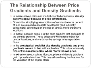
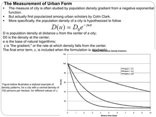
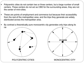
This document summarizes a paper that examines the spatial distribution of populations in cities around the world. It discusses how population density typically decreases exponentially from the urban center. It compares the spatial structures of Paris and Moscow, finding that Paris has a denser center and more efficient structure while Moscow has lower densities and residents farther from the center on average. The document also discusses how central planning in the Soviet Union led to less efficient urban forms compared to market-driven cities where form follows price gradients.
A city region is a metropolitan area and surrounding areas that function together economically. It typically includes multiple administrative districts but shares resources like a central business district, labor market, and transportation network. City regions are defined by dominant commuting patterns rather than arbitrary boundaries. Over time, city regions change shape as populations and economic activity shift. A city's influence decreases with distance from its center, but it exerts dominance over surrounding towns and cities through provision of specialized services. In India, city regions have formed around major cities through clusters of urban settlements in their areas of influence.
Ebenezer Howard's 1898 work contrasted rural and urban life, proposing "Garden Cities" that incorporated the best of both, such as Letchworth (1903) and Welwyn Garden City (1920). While well-intentioned, garden cities often functioned merely as dormitories for larger cities and did not fully achieve their egalitarian vision. Bid rent theory shows how much different sectors are willing to pay for land in various locations, with retail highest in the city center and residential uses on the outskirts. Variations of this model account for factors like transportation intersections and suburban centers.
Regional planning is important for several reasons including addressing cultural differences, urbanization challenges, and economic issues between regions. There are two main approaches to regional planning: intra-regional which focuses on land use and meeting needs within a region, and inter-regional which aims to balance economic growth, employment, and development between regions. Examples of regional planning in Kenya include the 1978 Human Settlement Strategy and the Kenya Vision 2030 development framework. In summary, regional planning plays a significant role in country development by taking approaches between and within regions at an intermediate level between national and local plans.
In context of India n comparing it with the world. The presentation defines these concepts with apt case studies from various countries and India as well..
The document describes various characteristics used to describe settlements, including site, situation, function, shape, population, and area. It discusses important site factors that influenced where settlements were located, such as access to water sources, defensive positioning, and shelter from aspects. Situation describes a settlement's location in relation to other features. Function refers to a settlement's main economic and social activities. Shape can be dispersed, nucleated, or linear. Settlement hierarchies rank settlements based on size and importance.
1. The document discusses land use in urban areas, describing how urban land is divided into zones including the central business district (CBD), inner city, inner suburbs, and outer suburbs.
2. It summarizes the work of urban theorist Ernest Burgess, who proposed that cities develop in concentric zones, with the CBD at the center and different land uses like residential and industrial in each successive zone moving outward.
3. The document provides examples of typical land uses and characteristics within each zone, such as high-rise buildings and expensive land in the CBD, terraced housing in the inner city, and detached houses with driveways in the outer suburbs.
This document provides an overview of urban planning, sustainable development, sustainable architecture, and sustainable cities. It discusses the history and theories of urban planning and how planners guide development. Technical aspects of planning like land use and infrastructure are examined. The roles of sustainable development, sustainable architecture, and creating sustainable cities to meet needs without compromising the future are also summarized. Urban planning aims to optimize communities while balancing environmental, economic, and social considerations.
Christaller's Central Place Theory proposes that settlements will be arranged in a hierarchical pattern with higher order central places that provide more specialized services located further apart and dominating larger areas than lower order places. The theory assumes evenly distributed populations, resources, and transportation costs. Central places are arranged in hexagonal market areas. Christaller identified three principles for their arrangement: marketing (k=3), transportation (k=4), and administrative (k=7). While the theory describes observed urban hierarchies, its assumptions rarely hold exactly due to variable factors like transportation costs, resources, and government intervention. It remains useful for understanding trade and service center locations.
Von Thunen published his theory of agricultural land use patterns in 1826 in his book "The Isolated State". The theory was based on an isolated region with homogeneous climate and soil quality where the only mode of transportation was by foot. It proposed that there would be concentric zones of land use radiating from the city center based on transport costs and product perishability. Dairy farming would be in the innermost zone due to high transport costs of perishable products, followed by zones for forestry, vegetables, and grazing further from the city. The bid rent curve showed the relationship between economic rent and distance from the market. While pioneering, the theory was based on unrealistic assumptions and had limitations in applying to contemporary systems
This document discusses rural settlement patterns in Asia, focusing on patterns found in Bangladesh. It describes the main types of rural settlements as nucleated, dispersed, elongated, and cluster villages. For Bangladesh specifically, it outlines the nucleated, linear, and dispersed settlement patterns found in different regions, including the Barind region, active delta region, and haor areas. It also provides examples of different house types found across Asia, including India, Nepal, Bangladesh, and Sri Lanka.
- The document discusses the importance of preserving open spaces and vegetation in urban planning to balance environmental, social and economic needs. It notes trees and vegetation provide aesthetic, climatic and engineering benefits.
- It outlines various values and benefits of trees related to architecture, climate, site development and engineering like moderating temperatures, intercepting rainfall, stabilizing soils and reducing pollution. Trees also have economic and legal value by enhancing property values.
- Jurisdictions have enacted preservation ordinances to balance development with resource protection. Successful preservation must integrate into early planning stages rather than be retrofitted later. Proper protection of trees during construction is also important to prevent root damage.
Regional planning deals with efficient placement of land uses like farmland, cities, infrastructure, and wilderness across a larger area than individual towns. A region requires various land uses to support protection of farmland, cities, industry, transportation, and other needs. Regional development addresses region-wide environmental, social and economic issues through efficient infrastructure placement and zoning to sustainably grow a region.
Basic Concept of Human Settlement by Martin Adlaon Arnaiz Jr.Martin Arnaiz
Human settlements can take many forms depending on factors like location, population size, and level of development. The document outlines the basic components and types of human settlements from isolated dwellings and hamlets to towns, cities, and conurbations. It describes key characteristics like services available and population thresholds. Rural settlements tend to be more dispersed while urban areas are often nucleated or planned. A settlement's functions also vary and can include residential, administrative, industrial, commercial, service provision, and tourism roles.
The Central Business District (CBD) is the commercial, cultural, and transportation center of a city. It faces competition from internet shopping, retail parks, and huge out of town supermarkets and business parks. As a result, some CBDs have experienced decline with empty shops and offices moving to the outskirts of cities. To revitalize the CBD, cities can pedestrianize areas, bring empty buildings back into use, improve safety and security, create a nicer environment, and hold special events to attract people back into the center.
Ernest Burgess developed the concentric zone theory in the 1920s to model urban spatial patterns. The theory proposes that a city is organized into 5 concentric rings radiating out from the central business district. Zone 1 is the CBD with commercial activities. Zone 2 is a transitional zone with factories and abandoned buildings. Zone 3 is inhabited by working-class residents in tenements. Zone 4 contains middle-class houses, yards, and garages. Zone 5 is located furthest from the CBD and contains upper-class houses and suburbs. The theory argues that socioeconomic status decreases the further one moves from the CBD.
Patterns of land use in towns and citiesjaganshettar
This document discusses patterns of land use in towns and cities. It begins by listing common land uses found in urban areas like offices, shops, factories, housing, parks, and educational institutions. It then explains that while all towns are different, most have developed in a similar pattern from the central business district outward. An urban model is presented to illustrate the typical zones of land use from the CBD to inner city industrial and residential areas, and further out to inner and outer suburbs with newer housing, industrial parks, and open spaces. The document concludes by noting that land values are highest near the CBD and transportation routes, and decrease with greater distance from the center.
The document discusses the growth pole theory introduced by French economist Francis Perroux. The theory proposes that economic growth does not occur uniformly across a region, but rather concentrates around specific poles or points of growth. A growth pole is defined as a central location of economic activity that ignites growth and improves quality of life in surrounding areas. The document provides examples of Vallabh Vidyanagar and Ankleshwar in India which developed from educational and industrial growth poles respectively, attracting new economic clusters and population agglomerations around the initial primary poles.
Theories and models for Regional planning and developmentKamlesh Kumar
This is a work on the major theories of Regional planning mainly consisting the work of Francois Perroux, Gunnar Myrdal, Albert O. Hirschman, Walter Whitman Rostow and John Friedman.
Urban sprawl refers to the rapid outward expansion of metropolitan areas into low-density rural lands, characterized by single-use zoning, reliance on automobiles, and homogenous design. It was facilitated by the rise of automobiles and subsidized housing in the 1940s. Environmental issues caused by sprawl include increased emissions, air and water pollution, and lack of physical activity has led to health problems like obesity and diabetes. While sprawl provides benefits like affordable housing, it has negative economic, environmental and social impacts on communities.
This document discusses different patterns of rural settlements. It begins by defining patterns of settlement and noting that topography and culture influence settlement patterns. It then describes common rural settlement patterns including rectangular, linear, circular, star-shaped, triangular, and nebular. Specific examples of each pattern are provided. The document also discusses common patterns of rural settlements in Bangladesh, including nucleated, linear, disperse, compact, and scattered settlements. Examples of each type in different Bangladeshi regions are provided.
The rank size rule attempts to establish a numerical relationship between population sizes of settlements within a country or region. It ranks settlements by population size, with the largest first. It assumes the second largest settlement will be half the population of the largest, the third largest a third, and so on. While variations often occur, it provides a model for comparing city population distributions. Exceptions include primate cities, where one city dominates population size, and binary distributions, where two cities are of almost equal size.
Application of Remote Sensing and GIS in Urban PlanningKARTHICK KRISHNA
This document discusses the application of remote sensing and GIS in urban planning. It outlines how remote sensing provides important data for mapping land use and monitoring environmental changes. GIS allows for spatial analysis and modeling of terrain, watersheds, and growth patterns. The document gives examples of how remote sensing and GIS have been used together for base map preparation, land suitability analysis, delineating sensitive areas, and monitoring urban growth. It concludes that remote sensing and GIS provide an effective tool for data collection, analysis, and innovative planning methodologies.
1) High rise buildings are located in city centers because land is most expensive in the central business district (CBD) and building vertically maximizes profits from limited land.
2) Early urban models show concentric zones of land use radiating from the CBD based on decreasing economic rent, with more complex factors like transport routes and topography adding complexity.
3) The sector model recognizes that transport lines influence land use patterns, forming wedges of similar uses radiating from roads rather than perfect circles.
Central place theory attempts to explain the spatial distribution and hierarchy of settlements. It was first presented by German geographer Walter Christaller in 1933 based on a study in southern Germany. The theory proposes that settlements form a hierarchy based on the goods and services provided, with higher order settlements further apart and providing more specialized functions. Central place theory is based on the concepts of threshold, the minimum population needed to support a service, and range, the maximum distance people will travel to access a service. Christaller suggested settlements would form hexagonal market areas in an ideal scenario. However, the theory makes simplifying assumptions and the perfect patterns are not seen in reality.
This document discusses frameworks for explaining differences in metropolitan growth rates. It argues that existing frameworks based on specialization, human capital, and costs are limited because they do not fully explain why certain industries specialize in specific metropolitan areas over others. A more robust framework is needed that considers specialization, human capital, and institutions as endogenous and mutually reinforcing factors that shape metropolitan growth and change over time in complex and dynamic ways. The document calls for a new generation of research on metropolitan growth that adopts this more sophisticated theoretical approach.
This document summarizes a study examining the relationship between trade openness and city sizes using the New Economic Geography framework. The study finds that as trade openness increases, the size of main cities declines while the size of secondary cities increases. Similar results are seen for cities with over 1 million people. However, cities that make up a large share of the urban population do not see the same relationship with trade openness. The implications are that investment in infrastructure should target secondary cities during trade liberalization, especially port cities.
This document provides background information on Adriano Leonardi, including his education and professional experience. It discusses his realization while pursuing his PhD in urban planning that land prices play a central role in urban change and are determined by the needs of the dominant mode of production and the reproduction of societal structures. It also summarizes his thesis that the history of capitalism involves the continuous re-imposition of commodity form through the interplay of the market and state intervention, with land prices and spatial organization serving as means to produce and use urban space in accordance with the dominant mode of production and accumulation stage. The document outlines Leonardi's future research interests and areas of contribution.
This document proposes a typology of street trading based on mobility within public space and proximity to public/private interfaces. It discusses how street trading is an important part of the urban economy in global south cities, providing income for the urban poor. While authorities often view street trading negatively, it contributes vitality to streets and stimulates social interaction. The document explores how street traders negotiate their use of public space with different stakeholders and the state, and how formalization policies often aim to eliminate informality rather than understand the complex informal/formal dynamics. It reviews different types of street trading identified in previous research based on mobility and location. Developing a nuanced typology can help policymakers engage effectively with street trading without simply eradicating
The development of urban underground space is fundamentally driven by urban economic changes and growth. As cities develop and populations increase, more space is needed to accommodate these activities. The rise of the tertiary economic sector, focused on producer services, strengthened core urban functions and compacted urban forms. High-rise office and commercial clusters transformed urban skylines and reflected evolving economic structures. When agglomeration economies matured sufficiently, underground space provided an important way to further expand urban capacity in a sustainable manner by relieving pressure on surface development. However, underground development must be considered in the context of a city's overall economic strategy and growth expectations to be sustainable over the long term.
This document discusses a 2011 honors project that examines the paradoxical effect of intercity transportation and communications infrastructure on urban concentration. The project analyzes data from 84 countries between 1960 and 2010. It finds that while such infrastructure promotes population dispersion among connected areas, it also leads to population concentration from unconnected locations into connected ones. As a result, infrastructure only effectively reduces excessive concentration when the dispersion effect exceeds the concentration effect. The document reviews relevant literature and proposes using both primacy and urbanization measures to capture both dispersion and concentration effects.
This document summarizes a review study on urban sprawl. It begins by defining urban sprawl as excessive, uncontrolled growth of cities beyond their boundaries. It then discusses the characteristics of sprawl, including low-density development, segregation of land uses, and reliance on cars. Several causes of sprawl are identified, such as increases in income and population, improvements in transportation, and preferences for larger homes. The negative impacts of sprawl are then outlined, including increased infrastructure costs, more pollution, and loss of agricultural land. Finally, the document proposes some policies to control urban sprawl, like investing in public transit, controlling growth, and redeveloping inner cities.
Effects of Small Town's Centralization on Spatial Organization of Rural Settl...iosrjce
Centralization in small town is led to functional changes due to increasing Inequality between rural
settlement and cities. On the other hand, mentioned changes are different based on distance with urban center.
Also, these cities effect germ and parasitic role on rural area according to their structure.
The methodology of this study is descriptive –analytic and collecting data is done by documents-library. The
data are generally gathered from scientific centre libraries like universities, organizations, institutes and
research centers such as management and planning organization and internet, official statistics and censuses,
Urban Development Plans By Consulting Engineers, Field Study And So On. Studied Area Is Shandiz &
Torqabeh Cities. Infact, Has Been Studied The Effect Mentioned Cities On Hesar Golestan & Hesar Sorkh
Villages. In Order To , Was Used From Network Analyzed. On The Other Hand, Was Used From Questioner
Tool. Finding Shows, The Relation Between Urban And Rural Area Is Parasitic Theory.
Urban sprawl is driven by a variety of demographic, socioeconomic, political, technological, and geophysical factors. Population growth and changes in household size have contributed to sprawl throughout Europe. Higher incomes have led to a preference for detached homes on the urban periphery. The availability of automobiles diminished the importance of living near work, enabling more dispersed development. There is increasing concern about urban sprawl in Europe due to its environmental and social impacts. Monitoring and measurement of sprawl has relied on approaches integrating multiple variables or metrics.
This document discusses the internal structure of urban areas, including density patterns and land use classifications. It describes how urban structure aims to minimize the total distance between people and facilities by distributing some facilities locally and relying on transportation systems for other facilities. This creates a hierarchical structure with different levels of central places and transportation networks. The patterns of urban land use that develop are influenced by economic factors like bid rents and land values, which are highest near the urban center and transportation routes.
The document discusses the concept of peri-urbanization, which refers to the dispersive urban growth that creates hybrid rural-urban landscapes in the areas surrounding cities. Some key points about peri-urbanization include:
- Peri-urban areas are growing rapidly worldwide and account for almost as much built development as urban areas.
- This rapid growth risks increased urban sprawl, but also presents opportunities to improve quality of life and link cities to surrounding rural areas more sustainably.
- Peri-urbanization is driven by population growth, shifting employment from agriculture to other sectors, and rising land costs.
- Most future rural-urban land conversion will occur in peri-urban areas, presenting environmental and service delivery challenges
Making Cities Work_Sustainable Growth and Sustainable ClimateRitwajit Das
This document discusses the importance of sustainable urban development and growth given that cities will account for most of the world's population growth and economic output over the next few decades. If current unplanned urban expansion continues, it will greatly increase costs and greenhouse gas emissions. Instead, the document advocates for a model of compact, connected, and coordinated urban planning that encourages higher densities, mixed land uses, public transit, and green spaces. Such strategic shifts towards more sustainable urban development patterns could boost economic productivity, improve quality of life, and significantly reduce emissions. The document argues that national urbanization strategies and stronger policies are needed to support this transition to more sustainable cities.
Urban and spatial planning and design play an important role in shaping sustainable and resilient cities. Effective planning promotes compact and connected urban forms that reduce sprawl, support public transportation, and encourage mixed-used development. This contrasts with unplanned urban extensions and car-centric development, which have led to less sustainable sprawling urban patterns. Good planning also fosters social inclusion, protects cultural heritage and the environment, strengthens resilience, and supports strong economies by improving productivity and land values. Public participation, multi-sectoral coordination, capacity building, and context-specific solutions are essential for successful urban and spatial planning.
B R O O K I N G SM E T R O P O L I TA N P O L I CY .docxcelenarouzie
B R O O K I N G S
M E T R O P O L I TA N
P O L I CY
P R O G RA M
6
I . I N T R O D U C T I O N
A
s the global economy has become more integrated and urbanized,
fueled in large part by technology, major cities and metropolitan
areas have become key engines of economic growth. The 123 largest
metro areas in the world generate nearly one third of global output
with only 13 percent of the world’s population.
In this urban-centered world, the classic notion of a
global city has been upended. This report introduces
a redefined map of global cities, drawing on a new
typology that demonstrates how metro areas vary in
the ways they attract and amass economic drivers
and contribute to global economic growth in distinct
ways. New concerns about economic stagnation—in
both developing and developed economies—add
urgency to mapping the role of the world’s cities and
the extent to which they are well-positioned to deliver
the next round of global growth.1
Instead of a ranking or indexed score, which many
prior cities indices and reports have capably deliv-
ered,2 this analysis differentiates the assets and
challenges faced by seven types of global cities.
This perspective reveals that all major cities are
indeed global; they participate as critical nodes in
an integrated marketplace and are shaped by global
currents. But cities also operate from much differ-
ent starting points and experience diverse economic
trajectories. Concerns about global growth, productiv-
ity, and wages are not monolithic, and so this typology
can inform the variety of paths cities take to address
these challenges. For metro leaders, this typology
can also ensure better application of peer com-
parisons, enable the identification of more relevant
global innovations to local challenges, and reinforce a
city-region’s relative role and performance to inform
economic strategies that ensure ongoing prosperity.
This report proceeds in four parts. In the following
section, Part II, we explore the three global forces of
urbanization, globalization, and technological change,
and how together they are demanding that city-
regions focus on five core factors—traded clusters,
innovation, talent, infrastructure connectivity, and
governance—to bolster their economic competitive-
ness. Building on these factors, Part III outlines the
data and methods deployed to create the metropoli-
tan typology. Part IV explores the collective economic
clout of the metro areas in our sample and introduces
the new typology of global cities. Finally, Part V
explores the future investments, policies, and strate-
gies required for each grouping of metro areas. Within
the typology framework, we explore the priorities for
action going forward, including the implications for
governance.
REDEFINING
GLOBAL CITIES
THE SEVEN TYPES
OF GLOBAL METRO
ECONOMIES
7
U R B A N I Z AT I O N
The world is becoming more urba.
Urbanization refers to the population shift from rural to urban areas. Rapid urban growth has both positive and negative impacts on town planning. Positively, it can increase economic production and provide better opportunities and services. However, it can also lead to issues like urban sprawl, traffic, and pollution as megacities struggle to provide infrastructure for large populations. Effective town planning requires statutory development plans that provide strategies and proposals to manage growth, as well as regional plans that focus on balanced development across connected urban and rural areas.
Traditional saturation analysis on competitive location decision science focuses on diminishing returns for
incumbents and newcomers in a specific spatial location pertaining to commercial retail potential past a certain point of
market saturation. Methods/Findings: This study looks at this problem but employs a different approach to the subject
altogether, wherein saturation is no longer a variable affecting only retailers but one that affects both: the marginal utility
of consumers and the revenue of retailers albeit differently. A new mathematical model is proposed based on selected
papers, contributing new insight into an already widely discussed subject
This document discusses drivers of urban sprawl in Europe. It identifies several categories of drivers, including demographic (population size and structure, migration), socio-economic (GDP, lifestyle), political (policies, subsidies), technological (availability of cars and computers), and geophysical (topography). It notes that urban sprawl has increased over 1% annually in most European countries between 2006-2009 according to one measurement method. There is growing concern about urban sprawl's environmental and social impacts across Europe.
Analyzing small town centralization effects on spatial organization of rural ...inventionjournals
ABSTRACT : Nowadays, unbalancing and inequality of spaces among urban and rural settlements are important subjects of economists and regional programmers. Existing economical divergence, development poles and dispersion of rural regions are the effects of this phenomenon.So accessing to balance and consistent expansion in regional space, establishing regular and ordered sequences are major needs and pay attention to small towns is one of the ways to equilibration this situation.The purpose of research is, studying influence Torqabeh & Shandiz cities on Zosh, Noqondar, Virani villages. The research is applied and method is descriptive –analytic and collecting data is done by documents-library. Indeed, has been studied the effect of centralization mentioned cities on villages. In order to, was used from network analyzed. On the other hand, was used from questioner tool. Finding shows, the relation between urban and rural area is parasitic theory.
IRJET-About Urban Sprawl: A Case Study of Ahmedabad CityIRJET Journal
This document discusses urban sprawl in Ahmedabad City, India. It defines urban sprawl as excessive metropolitan decentralization or suburbanization that results in low density settlements and a decentralized pattern of growth. The document examines urban sprawl in Chandkheda and Kathwada neighborhoods on the edge of Ahmedabad City. Both areas are experiencing population growth and loss of agricultural land to housing and industry. This uncontrolled growth leads to issues like increased traffic, air and water pollution, and stress on resources. Solutions discussed include smart growth practices like mixed use development and improved transit to reduce sprawl's negative environmental impacts.
Similar to Spatial distribution of population (20)
State of Artificial intelligence Report 2023kuntobimo2016
Artificial intelligence (AI) is a multidisciplinary field of science and engineering whose goal is to create intelligent machines.
We believe that AI will be a force multiplier on technological progress in our increasingly digital, data-driven world. This is because everything around us today, ranging from culture to consumer products, is a product of intelligence.
The State of AI Report is now in its sixth year. Consider this report as a compilation of the most interesting things we’ve seen with a goal of triggering an informed conversation about the state of AI and its implication for the future.
We consider the following key dimensions in our report:
Research: Technology breakthroughs and their capabilities.
Industry: Areas of commercial application for AI and its business impact.
Politics: Regulation of AI, its economic implications and the evolving geopolitics of AI.
Safety: Identifying and mitigating catastrophic risks that highly-capable future AI systems could pose to us.
Predictions: What we believe will happen in the next 12 months and a 2022 performance review to keep us honest.
Predictably Improve Your B2B Tech Company's Performance by Leveraging DataKiwi Creative
Harness the power of AI-backed reports, benchmarking and data analysis to predict trends and detect anomalies in your marketing efforts.
Peter Caputa, CEO at Databox, reveals how you can discover the strategies and tools to increase your growth rate (and margins!).
From metrics to track to data habits to pick up, enhance your reporting for powerful insights to improve your B2B tech company's marketing.
- - -
This is the webinar recording from the June 2024 HubSpot User Group (HUG) for B2B Technology USA.
Watch the video recording at https://youtu.be/5vjwGfPN9lw
Sign up for future HUG events at https://events.hubspot.com/b2b-technology-usa/
06-04-2024 - NYC Tech Week - Discussion on Vector Databases, Unstructured Data and AI
Discussion on Vector Databases, Unstructured Data and AI
https://www.meetup.com/unstructured-data-meetup-new-york/
This meetup is for people working in unstructured data. Speakers will come present about related topics such as vector databases, LLMs, and managing data at scale. The intended audience of this group includes roles like machine learning engineers, data scientists, data engineers, software engineers, and PMs.This meetup was formerly Milvus Meetup, and is sponsored by Zilliz maintainers of Milvus.
ViewShift: Hassle-free Dynamic Policy Enforcement for Every Data LakeWalaa Eldin Moustafa
Dynamic policy enforcement is becoming an increasingly important topic in today’s world where data privacy and compliance is a top priority for companies, individuals, and regulators alike. In these slides, we discuss how LinkedIn implements a powerful dynamic policy enforcement engine, called ViewShift, and integrates it within its data lake. We show the query engine architecture and how catalog implementations can automatically route table resolutions to compliance-enforcing SQL views. Such views have a set of very interesting properties: (1) They are auto-generated from declarative data annotations. (2) They respect user-level consent and preferences (3) They are context-aware, encoding a different set of transformations for different use cases (4) They are portable; while the SQL logic is only implemented in one SQL dialect, it is accessible in all engines.
#SQL #Views #Privacy #Compliance #DataLake
STATATHON: Unleashing the Power of Statistics in a 48-Hour Knowledge Extravag...sameer shah
"Join us for STATATHON, a dynamic 2-day event dedicated to exploring statistical knowledge and its real-world applications. From theory to practice, participants engage in intensive learning sessions, workshops, and challenges, fostering a deeper understanding of statistical methodologies and their significance in various fields."
06-04-2024 - NYC Tech Week - Discussion on Vector Databases, Unstructured Data and AI
Round table discussion of vector databases, unstructured data, ai, big data, real-time, robots and Milvus.
A lively discussion with NJ Gen AI Meetup Lead, Prasad and Procure.FYI's Co-Found
Beyond the Basics of A/B Tests: Highly Innovative Experimentation Tactics You...Aggregage
This webinar will explore cutting-edge, less familiar but powerful experimentation methodologies which address well-known limitations of standard A/B Testing. Designed for data and product leaders, this session aims to inspire the embrace of innovative approaches and provide insights into the frontiers of experimentation!
The Ipsos - AI - Monitor 2024 Report.pdfSocial Samosa
According to Ipsos AI Monitor's 2024 report, 65% Indians said that products and services using AI have profoundly changed their daily life in the past 3-5 years.
2. Introduction
This paper Alain Bertaud is the first attempt to examine urban form
systematically around the world, with special reference to “transition
economies”.
The purpose of this paper is to extend the literature on urban form,
with special reference to developing and transition economies.
It present data on selected measures of urban form for about 50,
mostly large, metropolitan areas.
Our cities are drawn from all major regions, from rich countries and
poor, from market economies and economies in transition to market.
calculated, on a consistent basis, population density gradients for
almost 50 large cities in some twenty countries. They also
constructed an alternative measure of city population dispersion.
In a variety of second-stage analyses, we have examined several
potential determinants of urban form.
The focus has been on income, population, and the nature of the
regulatory regime. To a lesser extent, we have examined the role of
natural constraint (physical geography), and transport mode.
3. Spatial Structure and Why it
matters?
The spatial structure of a city is very complex.
It is the physical outcome of the subtle interactions over
centuries between land markets, and topography, infrastructure,
regulations, and taxation.
The complexity of urban spatial structures has often discouraged
attempts to analyze them and a fortiori to try to relate urban policy to
city shape.
Spatial aspects of urban development can have important impacts
on economic efficiency and on the quality of the urban
environment.
The evolution of urban form, shaped by the complex interaction
between market forces, public investment and regulations, is not
often monitored.
Consequently, the significant inefficiencies due to a poor spatial
structure are often ignored until it is too late to do anything about it.
On the other hand, progressive and well functioning municipal urban
planning departments will use spatial indicators to regularly monitor
urban development and to propose regulatory or public investment
action when necessary.
4. From an economic point of view, a city is a large labor and
consumer market; the larger the size of the market and the
lower the costs of transactions, the more prosperous is the
economy.
A deficient spatial structure fragments labour and consumer
markets into smaller less efficient markets; it contributes also to
higher transactions costs by unnecessarily increasing
distances between people and places.
A deficient spatial structure increases the length of the city
infrastructure network and therefore increases its capital and
operating costs.
Thus a deficient spatial structure can reduce a city’s
productivity.
From an environmental point of view, a deficient spatial structure
can decrease the quality of life by increasing the time spent on
transport, by increasing air pollution, and contributing to the
unnecessary expansion of urbanized areas in natural sites.
5. A city’s spatial structure is constantly evolving.
Because of a lack of political consensus or a clear vision on
spatial development, the combined effect of land use
regulations and infrastructure investments may be
inconsistent and contradict each other.
It is therefore important that municipalities monitor the
spatial trends of development and take regulatory remedial
action if this trend contradicts municipal objectives.
External economic conditions are continuously changing and are
unpredictable in the long term, the planning department of
municipalities should constantly monitor the evolution the
urban spatial structure, and adjust eventually the balance and
nature of regulatory incentives and disincentives.
6. Comparison b/w spatial Structures of
Paris and Moscow
Moscow and Paris are two cities2 of roughly 10 million people.
Paris is, like virtually all cities within a market system, subject to
planning and regulation, but location decisions are driven
primarily by markets.
Moscow, on the other hand, has for most of its post 1917 – pre-
Perestroika history, developed without reference to land or real
estate markets.
Paris Moscow
7. Paris spreads out from a very dense center; while Moscow has a
much smaller footprint. (In fact, Moscow’s footprint is only 53
percent of Paris’ footprint.)
Moscow the highest densities are in the periphery. Despite its
small footprint Moscow is not very compact.
The average distance of a Moscow resident to the center is 56
percent greater than in Paris.
Given that both cities exhibit a centralized pattern of employment
location (by the standards of large cities), Paris is by this
measure a more efficient city than Moscow.
8. The Efficiency of Alternative Urban
Forms
Under certain simplifying assumptions about the functional forms
of production and demand functions, an optimizing model of
urban producers and consumers yields a negative exponential
function for population density, with a dense center falling off
exponentially.
The most central assumption – and the one extremely important
for our current purpose – is the assumption that all
employment is located at the centre of the city.
Many papers and models show that even when this assumption
is relaxed, the general negative exponential shape can hold,
as long as there is a higher density of employment at the centre
than elsewhere.
Many models have been developed that relax this strict
monocentricity, including some that have two centres, some that
have a center and a beltline of employment, others that have
multiple nodes or a beltline.
But even in extremely decentralized labour markets such as
Los Angeles or Atlanta, population density still largely follows
the negative exponential in market economies.
9. In addition, many observers are concern with externalities that
are difficult to handle theoretically and even more so empirically.
For example, commuting and other interurban travel can
engender congestion. If energy is not appropriately priced, more
commuting can increase external costs including air pollution
as well as congestion.
The relationship between urban form and energy efficiency – or
at least gasoline use –has been highlighted by Newman and
Kenworthy (1989), which shows that gasoline use per capita
declines with urban density.
The welfare of inhabitants of cities in transition economies is
linked to energy use and pollution.
For example, despite less gasoline use and a lower GDP, Soviet
emissions – including those attributed to transport – are
generally at comparable levels to the United States.
Thus it is probable that much larger improvements in air quality
can come from improving automobiles and fuels, & these gains
are likely to be large compared to possible modest gains from
landuse changes.
10. Central Planning vs. Market
Oriented Development
The central planning problem is the dual of a competitive market
allocation.
Planners should be able to allocate a good or set of goods every bit
as efficiently as the market.
If a good is unpriced, it will be fundamentally misallocated. where a
good is unpriced and entry to the market is essentially free (e.g.
fisheries).
The market for land and real estate is slightly different. The good,
here land, is indeed unpriced; but entry is strictly controlled by a
central planning authority.
One of the central characteristics of market allocation processes is
that they are highly decentralized.
Any given actor – producer, consumer, or regulator – needs only
limited information about market conditions in their own small
patch of the economy.
Even with the best-trained, equipped and intentioned planners,
central planning as a way to run an economy breaks down because
11. The problem becomes even more difficult when we consider real
estate markets. Land and real estate is the majority of the
tangible capital stock in every country, market or socialist.
Further complicating matters, virtually every parcel of land, and
every piece of real property built upon this land, is unique. Land,
housing, and other forms of real estate are characterized by
extraordinary heterogeneity.
Land and real estate markets are characterized by strong
interdependencies and external costs and benefits.
Furthermore, an important characteristic of land is its access to
infrastructure; and infrastructure often exhibits extraordinary
economies of scale and elements of natural monopoly.
Thus in every market oriented economy, land and real estate are
and should be appropriately regulated and planned.
12. Another characteristic of market oriented real estate systems is
that development decisions are made primarily by private
actors, working under regulatory and property rights frameworks
set by governments and society.
Within this framework, their objective function is to maximize
profits, or revenue minus cost.
Another characteristic of market-oriented development is that
because individuals and firms have property rights in land, and
these rights can be alienated, there is an incentive to redevelop
land as a city grows and highest and best use changes.
Where there is no market for land or real estate, firms and
households have no markets in which to capture gains from
permitting redevelopment of their land; and in fact without such a
market, no one quite knows what the gains to redevelopment
are.
Without market reference, central planners in socialist
economies are at a loss for benchmarks for the efficient
allocation of land, even if that was their main objective.
13. The Relationship Between Price
Gradients and Density Gradients
In market-driven cities and market-oriented economies, density
patterns occur because of price differentials.
Once initial simplifying assumptions of constant returns per unit
of land are relaxed real estate developers (and indirectly
consumers) economize on the use of land at more expensive
locations.
In market-oriented cities, it is the price gradient that gives rise to
the density gradient. These prices are willingness to pay for
central locations, and are driven by savings in transportation
costs.
In the prototypical socialist city, density gradients and price
gradients are not in line with each other. This is fundamentally
different from market cities, where “form follows price.
In extreme cases, such as Moscow, price and density gradients
go in opposite directions. This has extraordinary implications for
the valuation of the capital stock.
14. The Measurement of Urban Form
The measure of city is often studied by population density gradient from a negative exponential
function.
But actually first popularized among urban scholars by Colin Clark.
More specifically, the population density of a city is hypothesized to follow
D is population density at distance u from the center of a city;
D0 is the density at the center;
e is the base of natural logarithms;
γ is "the gradient," or the rate at which density falls from the center.
The final error term, ε, is included when the formulation is stochastic.
Figure below illustrates a stylized example of
density patterns, for a city with a central density of
100 persons per hectare, for different values of γ.
15. The standard urban model of Alonso, Muth and Mills predicts that population
density gradients will fall as incomes rise, the city grows, and transport costs fall.
Brueckner point out that in Paris, there is a stronger tendency for richer
households to live centrally, while poor households often live in the suburbs.
This is in contrast to most North American cities.
Historic preservation and height restrictions prevent dense low-income housing
from being developed in the center, while public housing projects have been
located in the suburbs.
If rich live in the suburbs and the poor in central hinge on the income elasticity of
demand for housing (and land) exceed the income elasticity of transport costs.
DISPERSION
We know that cities come in many different shapes.
Cities shape can be defined by two variables:
• The surface of the built-up area, the shape of the built-up area
• The way the population density is distributed within this same built-up area.
We can thus represent a city as a 3-dimensional object.
16. We thus obtain a solid whose geometric properties can be analyzed.
Such a solid has a center of gravity, which is the point to which the sum of
distance from all other points of the shape is the shortest.
All else equal, a city shape which decreases the distance between people's
residences and the main place of work and consumption will be more
favorable to the functioning of labor and consumer markets.
For a given built-up area, the shorter the average distance per person to the
main place of work or to the main commercial areas, the better would be the
performance of the city shape.
Traditionally, planners and urban economists consider that a city is either
monocentric or polycentric, depending on the location of the main
employment and retail centers.
In reality no city is purely monocentric or purely polycentric.
Cities have only degrees of monocentrism and polycentrism.
17. Polycentric cities do not contain two or three centers, but a large number of small
centers. These centers do not act as CBD for the surrounding areas, they are not
the center of mini-cities.
These are points of employment and commerce but because their accessibility
from the rest of the metropolitan area, and the trips they generate are widely
distributed across the metropolitan area.
By contrast a theoretically pure monocentric city generates only trips along its
radius.
POLYCENTRIC CITIES MONOCENTRIC CITY
18. Dispersion index is the ratio between the average distance per person to the
CBD,
and the average distance to the center of gravity of a cylindrical city whose
circular base would be equal to the built-up area, and whose height will be the
average population density: