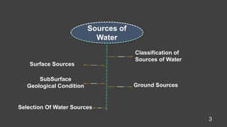
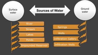
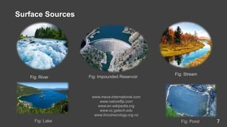
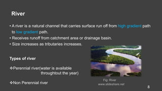
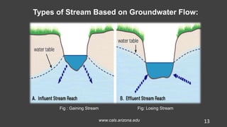
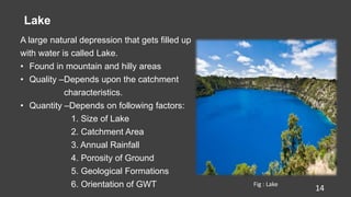
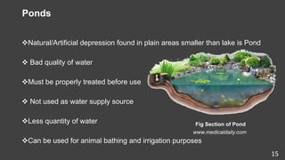
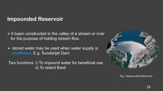
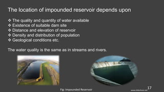
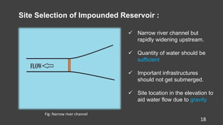
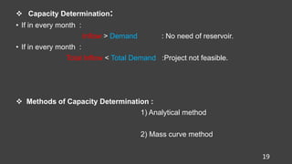
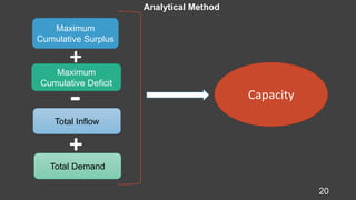
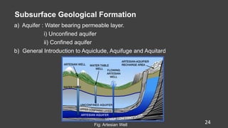
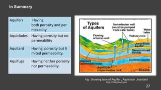
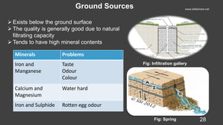
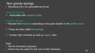
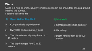
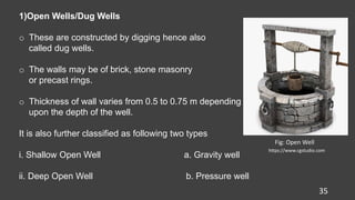
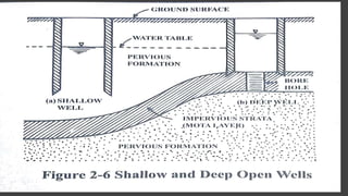
Sources of Water
Presented by
Prabhat (97)
Pradeep.S (98)
Pradeep.R (99)
Prafulla (100)
Pramod (101)
Prasanna (102)
Tutor
Asst. Prof. Shukra Raj Paudel
Department of Civil Engineering
IOE, Tribhuvan University
1
Able to know about water cycle
Can understand the various types of surface water
Can able to determine the capacity of impounded reservoir
Various types of ground water
Can understand about rainfall harvesting
Able to make best selection of water resources
After this presentation, we can able to understand about
2
3
Sources of
Water
Classification of
Sources of Water
Surface Sources
SubSurface
Geological Condition Ground Sources
Selection Of Water Sources
Surface
water
River
Stream
Lakes
Ponds
Impounded Reservoir
Ground
water
Springs
Wells
Infiltration Gallery
Infiltration Wells
Sources of Water
The Hydrological Cycle
www.class4beds.wordpress.com 5
6
Phenomena of Water Cycle
1 Evaporation Conversion of liquid water into gaseous state
2 Condensation Conversion of vapor into liquid
3 Precipitation Any form water that falls on earth surface
4 Infiltration Absorption of water into the soil layer
5 Runoff Flow of precipitated water from high to low
elevation below or above the surface
6 Evapotranspiration Release of water vapor from plants into air
7 Subsurface flow Flow of water below the ground surface
7
Surface Sources
Fig: River Fig: Impounded Reservoir
Fig: Stream
Fig: Lake Fig: Pond
www.meva-international.com
www.natureflip.com
www.en.wikipedia.org
www.cc.gatech.edu
www.lincolnecology.org.nz
River
• A river is a natural channel that carries surface run off from high gradient path
to low gradient path.
• Receives runoff from catchment area or drainage basin.
• Size increases as tributaries increases.
Fig: River
www.slideshare.net
8
Types of river
Perennial river(water is available
throughtout the year)
Non Perennial river
Hydraulic Structures Built Across the River:
Fig:Weir–Accumulate the flow 9
Fig:Dam-Creating Reservoir
Fig:Barrage-Diverting the flow
www.natureflip.com
Quality of River/Stream Water
• At Higher Altitudes: Better Quality
• At Lower Altitudes: Poor Quality due to
sediments
• Near Populated Cities: Worst Quality
10
Fig: Marsyandi River
Fig : Bagmati River
www.blog.nepaladvisor.com
www.sanjaal.com
www.youtube.com
www.blog.nepaladvisor.com
www.youtube.com
www.blog.nepaladvisor.com
www.sanjaal.com
Fig: River Koshi
Fig :River Karnali
Fig : River Narayani 11
Stream
• Natural Drainage Channel found in
Mountainous Region
• Smaller Size, Depth and Catchment Area
than River
• Quality of water is good except the first
Run off.
Fig:Stream
www.gravitysmith.com
12
Types of Stream Based on Groundwater Flow:
Fig : Gaining Stream Fig: Losing Stream
www.cals.arizona.edu 13
Lake
A large natural depression that gets filled up
with water is called Lake.
• Found in mountain and hilly areas
• Quality –Depends upon the catchment
characteristics.
• Quantity –Depends on following factors:
1. Size of Lake
2. Catchment Area
3. Annual Rainfall
4. Porosity of Ground
5. Geological Formations
6. Orientation of GWT 14
Fig : Lake
Ponds
Natural/Artificial depression found in plain areas smaller than lake is Pond
 Bad quality of water
Must be properly treated before use
 Not used as water supply source
Less quantity of water
Can be used for animal bathing and irrigation purposes
Fig Section of Pond
www.medicaldaily.com
15
Impounded Reservoir
16
It basin constructed in the valley of a stream or river
for the purpose of holding stream flow.
 stored water may be used when water supply is
insufficient. E.g. Sundarijal Dam
Two functions: i) To impound water for beneficial use
ii) To retard flood
Fig : Impounded Reservoir
17
The location of impounded reservoir depends upon
 The quality and quantity of water available
 Existence of suitable dam site
 Distance and elevation of reservoir
 Density and distribution of population
 Geological conditions etc.
The water quality is the same as in streams and rivers.
Fig: Impounded Reservoir www.slideshare.net
18
Site Selection of Impounded Reservoir :
 Narrow river channel but
rapidly widening upstream.
 Quantity of water should be
sufficient
 Important infrastructures
should not get submerged.
 Site location in the elevation to
aid water flow due to gravity
Fig: Narrow river channel
 Capacity Determination:
• If in every month :
Inflow > Demand : No need of reservoir.
• If in every month :
Total Inflow < Total Demand :Project not feasible.
 Methods of Capacity Determination :
1) Analytical method
2) Mass curve method
19
20
Maximum
Cumulative Surplus
Maximum
Cumulative Deficit
Total Inflow
Total Demand
Capacity
Analytical Method
+
-
+
21
Q) The yield of water from the catchment area is given below . Determine
analytically the minimum storage capacity of the impounded reservoir to
maintain a constant draft of 4.4 mill m of water per month . Neglect all losses
and wastage
3
Mon Jan Feb Mar Apr May Jun Jul Aug Sep Oct Nov Dec
Inflo
w (
Mil
m3 )
1.5 2.0 2.5 5.0 6.0 8.2 9.0 7.5 5.0 3.5 3.1 2.0
22
Capacity of impounded reservoir
=Max Cum. Surplus+Max. Cum. Deficit–Total Inflow+Total Demand
= 7.1+7.2-55.3+52.8= 11.8 Mm3
Solution :
Here , Water Demand = 4.4 Mm3/month
Month Inflow Demand Cum Inflow Cum Demand Cum Surplus Cum Deficit
Jan 1.5 4.4 1.5 4.4 2.9
Feb 2.0 4.4 3.5 8.8 5.3
Mar 2.5 4.4 6.0 13.2 7.2
Apr 5.0 4.4 11.0 17.6 6.6
May 6.0 4.4 17.0 22.0 5.0
Jun 8.2 4.4 25.2 26.4 1.2
Jul 9.0 4.4 34.2 30.8 3.4
Aug 7.5 4.4 41.7 35.2 6.5
Sep 5.0 4.4 46.7 39.6 7.1
Oct 3.5 4.4 50.2 44.0 6.2
Nov 3.1 4.4 53.3 48.4 4.9
Dec 2.0 4.4 55.3 52.8 2.5
Total 55.3 52.8
23
Subsurface Geological Formation
a) Aquifer : Water bearing permeable layer.
i) Unconfined aquifer
ii) Confined aquifer
b) General Introduction to Aquiclude, Aquifuge and Aquitard
Fig: Artesian Well
24
25
Aquifer
An aquifer is an underground layer of water bearing permeable rock, rock
fractures or unconsolidated materials (gravel, sand, or silt) from
which groundwater can be extracted using a water well.
Type of Aquifer
•Confined Aquifer
Those bodies of water that accumulate in the permeable rock and are
enclosed between two impermeable layers.
•Unconfined Aquifer
An unconfined aquifer groundwater level coincides with the surface
and is in direct contact with the soil under saturated zone
•Semi confined Aquifer
The less permeability, but is not waterproof, allowing discharge and
recharge occurs through this stratum.
26
Aquitard
•It is a formation through which only seepage is possible and thus the yield is
significant compared to an aquifer
•Appreciable quantities of water may leak to an aquifer below it
• It is partly permeable. e.g. sandy clay
Aquiclude
•It is porous but not permeable
•Argillaceous rocks like shale and clay are typical examples.
Aquifuge
• It is neither porous nor permeable.
•There are no interconnected openings and hence it cannot transmit water
• Naturally these are not suitable for ground water occurrence. Massive
granites and quartzite are typical examples.
27
In Summary
Aquifers Having
both porosity and per
meability
Aquicludes Having porosity but no
permeability
Aquitard Having porosity but li
mited permeability.
Aquifuge Having neither porosity
nor permeability.
Fig : Showing type of Aquifer , Aquiclude ,Aquitard
http://slideplayer.com
Ground Sources
Fig: Spring
Fig: Infiltration gallery
www.slideshare.net
28
Exists below the ground surface
The quality is generally good due to natural
filtrating capacity
Tends to have high mineral contents
Minerals Problems
Iron and
Manganese
Taste
Odour
Colour
Calcium and
Magnesium
Water hard
Iron and Sulphide Rotten egg odour
Springs
A natural flow of ground water as current or stream of flowing water.
29
1)Gravity Springs
• Resulting from gravitational
forces
Types
 Depression Springs
 Contact or Surface Springs
 Artesian Springs
Types
 Volcanic Springs
 Fissure springs
2)Non gravity springs
• Resulting from non gravitational
• forces
30
a) Depression springs
Fig :Depression Springwww.slideshare.net
Prof. Dr. Kansakar2015
 Formed due to overflowing of the water table where
the ground surface intersects water table .
 The flow is variable with the rise or fall of water
table
 In order to meet with such fluctuations, a deep
trench may be constructed.
 The saturated ground above the elevation of the
trench bottom will act as a storage reservoir.
Gravity Springs
• Resulting from gravitational forces
b. Contact or surface springs
 Created by a permeable water bearing
formation over lying a less permeable or
impermeable formation that intersects
the ground surface.
Fig : Contact Spring www.kgs.ku.edu
31
 Relatively small amount of underground
storage available above the elevation of
the overflow crest.
 The flow from them is uncertain and likely to c
ease after a drought.
 Suchsprings can also be developed by the c
construction of a cutoff trench or a cutoff wall.
32
c. Artesian Spring
 They result from release of water
under pressure from confined aquifers
either at an outcrop of the aquifer or through
an opening in the confining bed
Fig : Artesian spring
 The amount of water available in an artesian
spring may be large if the catchment area is large
 The flow may be slightly increased by removal of
obstructions from the mouth of the spring
33
Non gravity springs
• Resulting from non gravitational forces
Volcanic Spring
 Associated with volcanic rocks
Fissure spring
 Results from fractures extending to the great depths in the earth’s crust
 These are also called hot springs
 Contain high minerals as well as sulphur also
Uses
o Not for Domestic purposes
o Some may be useful for the cure of skin diseases
34
Wells
A well is a hole or shaft , usually vertical extended in the ground for bringing ground
water to the surface.
It can be classified into
1) Open Well or Dug Well
 Comparatively large diameter
 low yields and are not very deep
 The diameter usually vary from 1 to
10 meters.
 The depth ranges from 2 to 20
meters.
2)Tube Well
Comparatively small diameter
Very deep
Depth ranges from 30 to 600
meters
35
1)Open Wells/Dug Wells
o These are constructed by digging hence also
called dug wells.
o The walls may be of brick, stone masonry
or precast rings.
o Thickness of wall varies from 0.5 to 0.75 m depending
upon the depth of the well.
It is also further classified as following two types
i. Shallow Open Well a. Gravity well
ii. Deep Open Well b. Pressure well
Fig: Open Well
https://www.cgstudio.com
36
37
Shallow Open Wells Deep Open Wells
Rest on top water bearing strata Rest on impervious strata
Draw and Supplies from surrounding material Draw and Supplies from permeable formation
lying below impervious strata
Yield is less and uncertain due to variation in
groundwater table
Yield is more and uniform as there is no
fluctuations in water level
Used as a source for individual household Used for small community
Contain large amount of suspended particles and
bacterial contamination
May contain dissolved minerals
38
a) Gravity wells
o The water flows under gravity into the well and rises to the height saturated
material surrounding it
b) Pressure wells/Artesian wells
o Artesian wells coincide with the confined aquifer .
o The water is provided to the surface without any sort of assistance when
there is enough pressure in the aquifer.
Fig: Artesian Well
2) Tube Wells
- It is a long pipe sunk into the ground intercepting one or more water
bearing stratum.
The diameter are more or less as compared to the open well.
39
Shallow Wells : Max 30m
Deep Wells : Max 600m
These tube wells may be classified as:
i) Strainer type tube well
ii) Cavity type tube well
iii) Slotted type tube well
Fig : Tube Well
Cavity type of tube well
- Borehole is dug until it finds the previous
layer of water.
- Pumping is done and sandy water is
withdrawn
- Cavity formation occurs at the sandy layer
and thus water enters the sand pore at critical
velocity but less than in the cavity
- Thus after some time clear water is obtained
40
Strainer Type of tube well
- If not stated tube well means Strainer
type.
- The Strainer pipes and blinds pipes
are alternately placed.
- Strainer consist of Fine wire mesh
wrapped round a perforated pipe.
- Size of opening of wire mesh =D60,
D70 of surrounding soil.
41
Fig: Strainer Type Tube Well
Slotted type tube well
Derives water from aquifer using education pipe and casing
42www.slideshare.net
Infiltration Gallery
- Structure built to intercept and collect the
groundwater flowing into river or lake
-Horizontal or nearly horizontal tunnel ,
usually rectangular (arched also)
in cross section
-Also known as Horizontal Well
-It is generally located near a perennial
recharge source such as the bank or
under bed of a river and 3 to 10 meters
below the ground
-The quantity and quality depends
upon the location and area of coverage.
43
Fig :Infiltration Gallery
- Shallow wells constructed in series
along the bank of river to collect the
water seeping through the bank.
- Constructed of brick Masonry
- For purpose of inspection, manhole is
provided in the top cover of the well.
- Water has to pass through sandbed
and gets purified to some extent.
- Water flow from infiltration well to jack
well by gravity
44
Infiltration Wells
45
Selection of Water Sources
a. Location
 It should be near to the consumer’s area or town as far as possible.
 Location may be at higher elevation
b. Quantity of Water
 Meet the demand for that design period in the wet and dry seasons also.
 If possible, there should be sufficient supply for future extension of project.
c. Quality of Water
 The water should be safe and free from pathogenic bacteria, germs and pollution.
d. Cost
 Gravity system of flow is generally cheaper than pumping.
 Lesser the impurities, lesser the treatment and cost is reduced.
46
Thank you
For Watching

Source Of water

  • 1.
    Sources of Water Presentedby Prabhat (97) Pradeep.S (98) Pradeep.R (99) Prafulla (100) Pramod (101) Prasanna (102) Tutor Asst. Prof. Shukra Raj Paudel Department of Civil Engineering IOE, Tribhuvan University 1
  • 2.
    Able to knowabout water cycle Can understand the various types of surface water Can able to determine the capacity of impounded reservoir Various types of ground water Can understand about rainfall harvesting Able to make best selection of water resources After this presentation, we can able to understand about 2
  • 3.
    3 Sources of Water Classification of Sourcesof Water Surface Sources SubSurface Geological Condition Ground Sources Selection Of Water Sources
  • 4.
  • 5.
  • 6.
    6 Phenomena of WaterCycle 1 Evaporation Conversion of liquid water into gaseous state 2 Condensation Conversion of vapor into liquid 3 Precipitation Any form water that falls on earth surface 4 Infiltration Absorption of water into the soil layer 5 Runoff Flow of precipitated water from high to low elevation below or above the surface 6 Evapotranspiration Release of water vapor from plants into air 7 Subsurface flow Flow of water below the ground surface
  • 7.
    7 Surface Sources Fig: RiverFig: Impounded Reservoir Fig: Stream Fig: Lake Fig: Pond www.meva-international.com www.natureflip.com www.en.wikipedia.org www.cc.gatech.edu www.lincolnecology.org.nz
  • 8.
    River • A riveris a natural channel that carries surface run off from high gradient path to low gradient path. • Receives runoff from catchment area or drainage basin. • Size increases as tributaries increases. Fig: River www.slideshare.net 8 Types of river Perennial river(water is available throughtout the year) Non Perennial river
  • 9.
    Hydraulic Structures BuiltAcross the River: Fig:Weir–Accumulate the flow 9 Fig:Dam-Creating Reservoir Fig:Barrage-Diverting the flow www.natureflip.com
  • 10.
    Quality of River/StreamWater • At Higher Altitudes: Better Quality • At Lower Altitudes: Poor Quality due to sediments • Near Populated Cities: Worst Quality 10 Fig: Marsyandi River Fig : Bagmati River www.blog.nepaladvisor.com www.sanjaal.com
  • 11.
  • 12.
    Stream • Natural DrainageChannel found in Mountainous Region • Smaller Size, Depth and Catchment Area than River • Quality of water is good except the first Run off. Fig:Stream www.gravitysmith.com 12
  • 13.
    Types of StreamBased on Groundwater Flow: Fig : Gaining Stream Fig: Losing Stream www.cals.arizona.edu 13
  • 14.
    Lake A large naturaldepression that gets filled up with water is called Lake. • Found in mountain and hilly areas • Quality –Depends upon the catchment characteristics. • Quantity –Depends on following factors: 1. Size of Lake 2. Catchment Area 3. Annual Rainfall 4. Porosity of Ground 5. Geological Formations 6. Orientation of GWT 14 Fig : Lake
  • 15.
    Ponds Natural/Artificial depression foundin plain areas smaller than lake is Pond  Bad quality of water Must be properly treated before use  Not used as water supply source Less quantity of water Can be used for animal bathing and irrigation purposes Fig Section of Pond www.medicaldaily.com 15
  • 16.
    Impounded Reservoir 16 It basinconstructed in the valley of a stream or river for the purpose of holding stream flow.  stored water may be used when water supply is insufficient. E.g. Sundarijal Dam Two functions: i) To impound water for beneficial use ii) To retard flood Fig : Impounded Reservoir
  • 17.
    17 The location ofimpounded reservoir depends upon  The quality and quantity of water available  Existence of suitable dam site  Distance and elevation of reservoir  Density and distribution of population  Geological conditions etc. The water quality is the same as in streams and rivers. Fig: Impounded Reservoir www.slideshare.net
  • 18.
    18 Site Selection ofImpounded Reservoir :  Narrow river channel but rapidly widening upstream.  Quantity of water should be sufficient  Important infrastructures should not get submerged.  Site location in the elevation to aid water flow due to gravity Fig: Narrow river channel
  • 19.
     Capacity Determination: •If in every month : Inflow > Demand : No need of reservoir. • If in every month : Total Inflow < Total Demand :Project not feasible.  Methods of Capacity Determination : 1) Analytical method 2) Mass curve method 19
  • 20.
    20 Maximum Cumulative Surplus Maximum Cumulative Deficit TotalInflow Total Demand Capacity Analytical Method + - +
  • 21.
    21 Q) The yieldof water from the catchment area is given below . Determine analytically the minimum storage capacity of the impounded reservoir to maintain a constant draft of 4.4 mill m of water per month . Neglect all losses and wastage 3 Mon Jan Feb Mar Apr May Jun Jul Aug Sep Oct Nov Dec Inflo w ( Mil m3 ) 1.5 2.0 2.5 5.0 6.0 8.2 9.0 7.5 5.0 3.5 3.1 2.0
  • 22.
    22 Capacity of impoundedreservoir =Max Cum. Surplus+Max. Cum. Deficit–Total Inflow+Total Demand = 7.1+7.2-55.3+52.8= 11.8 Mm3 Solution : Here , Water Demand = 4.4 Mm3/month Month Inflow Demand Cum Inflow Cum Demand Cum Surplus Cum Deficit Jan 1.5 4.4 1.5 4.4 2.9 Feb 2.0 4.4 3.5 8.8 5.3 Mar 2.5 4.4 6.0 13.2 7.2 Apr 5.0 4.4 11.0 17.6 6.6 May 6.0 4.4 17.0 22.0 5.0 Jun 8.2 4.4 25.2 26.4 1.2 Jul 9.0 4.4 34.2 30.8 3.4 Aug 7.5 4.4 41.7 35.2 6.5 Sep 5.0 4.4 46.7 39.6 7.1 Oct 3.5 4.4 50.2 44.0 6.2 Nov 3.1 4.4 53.3 48.4 4.9 Dec 2.0 4.4 55.3 52.8 2.5 Total 55.3 52.8
  • 23.
  • 24.
    Subsurface Geological Formation a)Aquifer : Water bearing permeable layer. i) Unconfined aquifer ii) Confined aquifer b) General Introduction to Aquiclude, Aquifuge and Aquitard Fig: Artesian Well 24
  • 25.
    25 Aquifer An aquifer isan underground layer of water bearing permeable rock, rock fractures or unconsolidated materials (gravel, sand, or silt) from which groundwater can be extracted using a water well. Type of Aquifer •Confined Aquifer Those bodies of water that accumulate in the permeable rock and are enclosed between two impermeable layers. •Unconfined Aquifer An unconfined aquifer groundwater level coincides with the surface and is in direct contact with the soil under saturated zone •Semi confined Aquifer The less permeability, but is not waterproof, allowing discharge and recharge occurs through this stratum.
  • 26.
    26 Aquitard •It is aformation through which only seepage is possible and thus the yield is significant compared to an aquifer •Appreciable quantities of water may leak to an aquifer below it • It is partly permeable. e.g. sandy clay Aquiclude •It is porous but not permeable •Argillaceous rocks like shale and clay are typical examples. Aquifuge • It is neither porous nor permeable. •There are no interconnected openings and hence it cannot transmit water • Naturally these are not suitable for ground water occurrence. Massive granites and quartzite are typical examples.
  • 27.
    27 In Summary Aquifers Having bothporosity and per meability Aquicludes Having porosity but no permeability Aquitard Having porosity but li mited permeability. Aquifuge Having neither porosity nor permeability. Fig : Showing type of Aquifer , Aquiclude ,Aquitard http://slideplayer.com
  • 28.
    Ground Sources Fig: Spring Fig:Infiltration gallery www.slideshare.net 28 Exists below the ground surface The quality is generally good due to natural filtrating capacity Tends to have high mineral contents Minerals Problems Iron and Manganese Taste Odour Colour Calcium and Magnesium Water hard Iron and Sulphide Rotten egg odour
  • 29.
    Springs A natural flowof ground water as current or stream of flowing water. 29 1)Gravity Springs • Resulting from gravitational forces Types  Depression Springs  Contact or Surface Springs  Artesian Springs Types  Volcanic Springs  Fissure springs 2)Non gravity springs • Resulting from non gravitational • forces
  • 30.
    30 a) Depression springs Fig:Depression Springwww.slideshare.net Prof. Dr. Kansakar2015  Formed due to overflowing of the water table where the ground surface intersects water table .  The flow is variable with the rise or fall of water table  In order to meet with such fluctuations, a deep trench may be constructed.  The saturated ground above the elevation of the trench bottom will act as a storage reservoir. Gravity Springs • Resulting from gravitational forces
  • 31.
    b. Contact orsurface springs  Created by a permeable water bearing formation over lying a less permeable or impermeable formation that intersects the ground surface. Fig : Contact Spring www.kgs.ku.edu 31  Relatively small amount of underground storage available above the elevation of the overflow crest.  The flow from them is uncertain and likely to c ease after a drought.  Suchsprings can also be developed by the c construction of a cutoff trench or a cutoff wall.
  • 32.
    32 c. Artesian Spring They result from release of water under pressure from confined aquifers either at an outcrop of the aquifer or through an opening in the confining bed Fig : Artesian spring  The amount of water available in an artesian spring may be large if the catchment area is large  The flow may be slightly increased by removal of obstructions from the mouth of the spring
  • 33.
    33 Non gravity springs •Resulting from non gravitational forces Volcanic Spring  Associated with volcanic rocks Fissure spring  Results from fractures extending to the great depths in the earth’s crust  These are also called hot springs  Contain high minerals as well as sulphur also Uses o Not for Domestic purposes o Some may be useful for the cure of skin diseases
  • 34.
    34 Wells A well isa hole or shaft , usually vertical extended in the ground for bringing ground water to the surface. It can be classified into 1) Open Well or Dug Well  Comparatively large diameter  low yields and are not very deep  The diameter usually vary from 1 to 10 meters.  The depth ranges from 2 to 20 meters. 2)Tube Well Comparatively small diameter Very deep Depth ranges from 30 to 600 meters
  • 35.
    35 1)Open Wells/Dug Wells oThese are constructed by digging hence also called dug wells. o The walls may be of brick, stone masonry or precast rings. o Thickness of wall varies from 0.5 to 0.75 m depending upon the depth of the well. It is also further classified as following two types i. Shallow Open Well a. Gravity well ii. Deep Open Well b. Pressure well Fig: Open Well https://www.cgstudio.com
  • 36.
  • 37.
    37 Shallow Open WellsDeep Open Wells Rest on top water bearing strata Rest on impervious strata Draw and Supplies from surrounding material Draw and Supplies from permeable formation lying below impervious strata Yield is less and uncertain due to variation in groundwater table Yield is more and uniform as there is no fluctuations in water level Used as a source for individual household Used for small community Contain large amount of suspended particles and bacterial contamination May contain dissolved minerals
  • 38.
    38 a) Gravity wells oThe water flows under gravity into the well and rises to the height saturated material surrounding it b) Pressure wells/Artesian wells o Artesian wells coincide with the confined aquifer . o The water is provided to the surface without any sort of assistance when there is enough pressure in the aquifer. Fig: Artesian Well
  • 39.
    2) Tube Wells -It is a long pipe sunk into the ground intercepting one or more water bearing stratum. The diameter are more or less as compared to the open well. 39 Shallow Wells : Max 30m Deep Wells : Max 600m These tube wells may be classified as: i) Strainer type tube well ii) Cavity type tube well iii) Slotted type tube well Fig : Tube Well
  • 40.
    Cavity type oftube well - Borehole is dug until it finds the previous layer of water. - Pumping is done and sandy water is withdrawn - Cavity formation occurs at the sandy layer and thus water enters the sand pore at critical velocity but less than in the cavity - Thus after some time clear water is obtained 40
  • 41.
    Strainer Type oftube well - If not stated tube well means Strainer type. - The Strainer pipes and blinds pipes are alternately placed. - Strainer consist of Fine wire mesh wrapped round a perforated pipe. - Size of opening of wire mesh =D60, D70 of surrounding soil. 41 Fig: Strainer Type Tube Well
  • 42.
    Slotted type tubewell Derives water from aquifer using education pipe and casing 42www.slideshare.net
  • 43.
    Infiltration Gallery - Structurebuilt to intercept and collect the groundwater flowing into river or lake -Horizontal or nearly horizontal tunnel , usually rectangular (arched also) in cross section -Also known as Horizontal Well -It is generally located near a perennial recharge source such as the bank or under bed of a river and 3 to 10 meters below the ground -The quantity and quality depends upon the location and area of coverage. 43 Fig :Infiltration Gallery
  • 44.
    - Shallow wellsconstructed in series along the bank of river to collect the water seeping through the bank. - Constructed of brick Masonry - For purpose of inspection, manhole is provided in the top cover of the well. - Water has to pass through sandbed and gets purified to some extent. - Water flow from infiltration well to jack well by gravity 44 Infiltration Wells
  • 45.
    45 Selection of WaterSources a. Location  It should be near to the consumer’s area or town as far as possible.  Location may be at higher elevation b. Quantity of Water  Meet the demand for that design period in the wet and dry seasons also.  If possible, there should be sufficient supply for future extension of project. c. Quality of Water  The water should be safe and free from pathogenic bacteria, germs and pollution. d. Cost  Gravity system of flow is generally cheaper than pumping.  Lesser the impurities, lesser the treatment and cost is reduced.
  • 46.