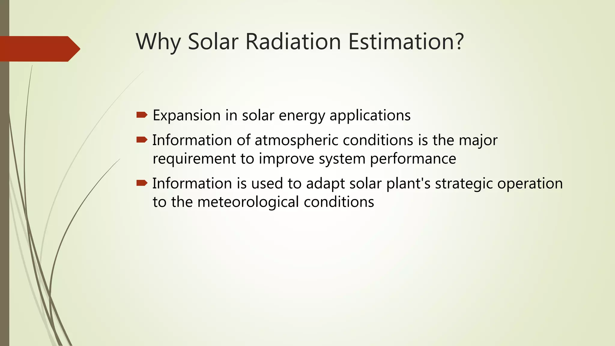
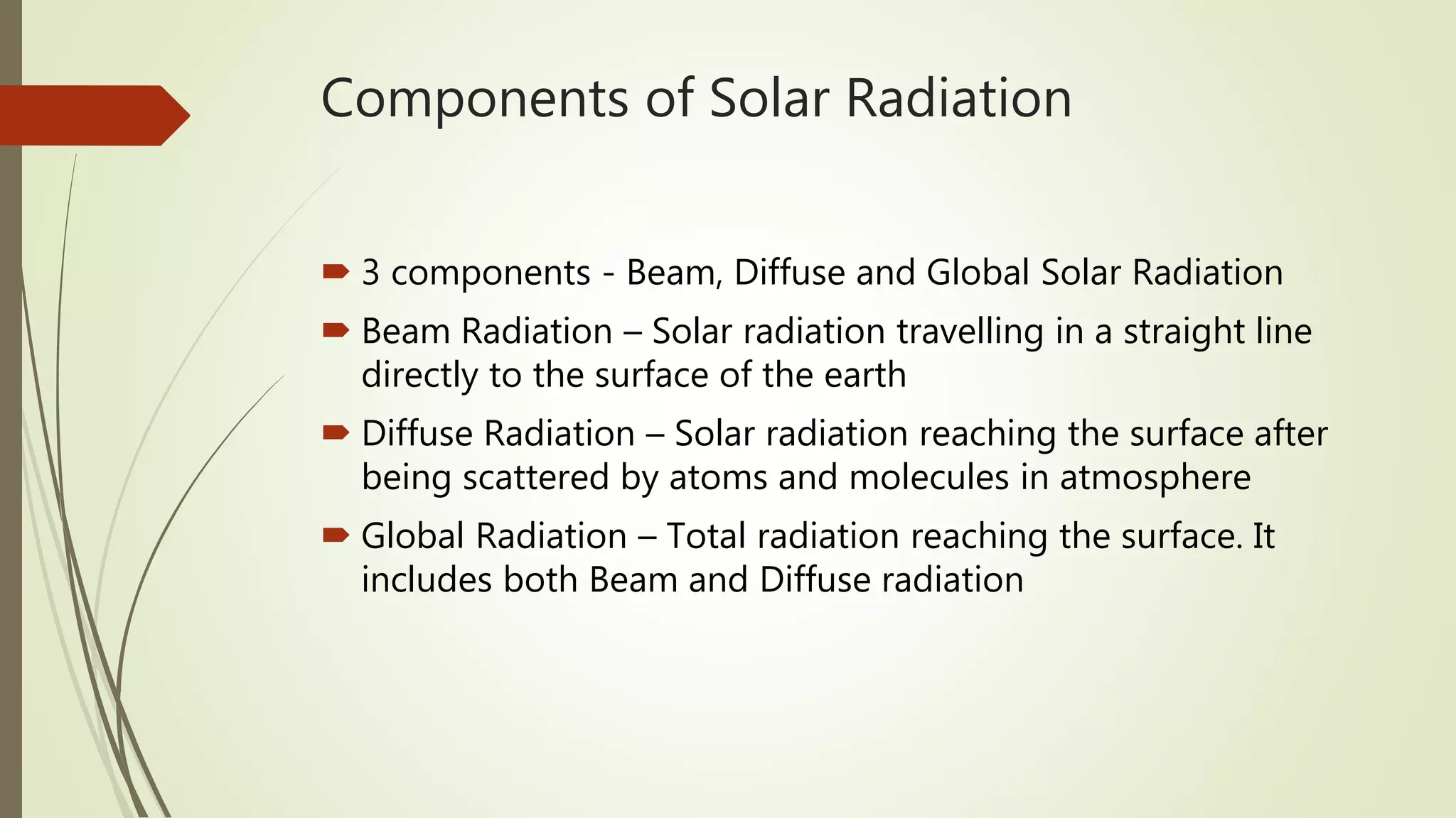
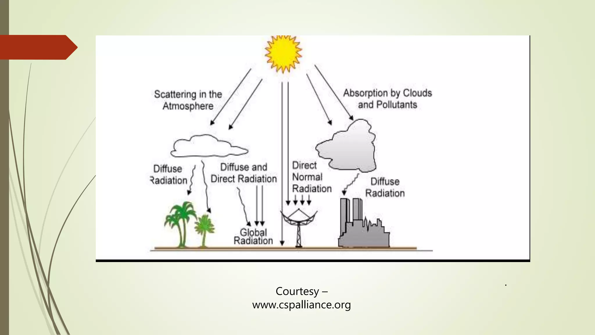
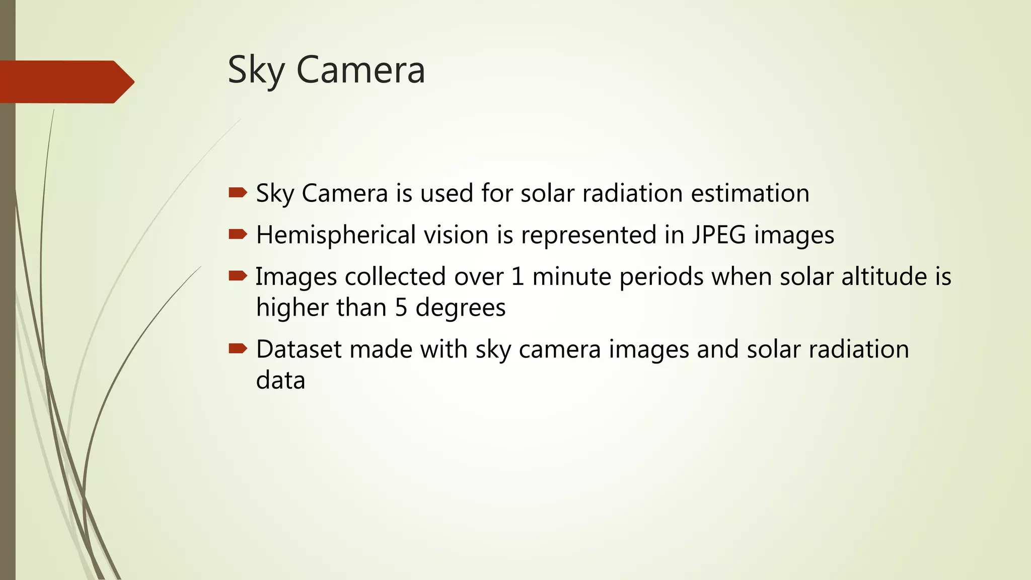
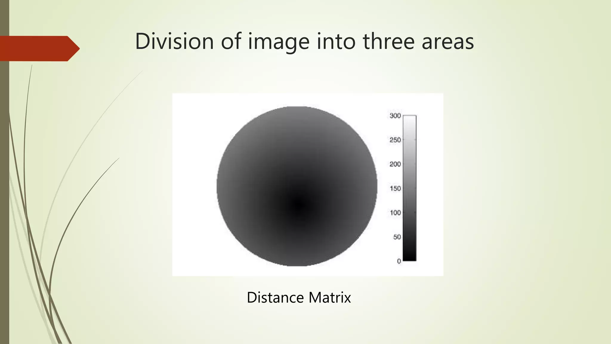
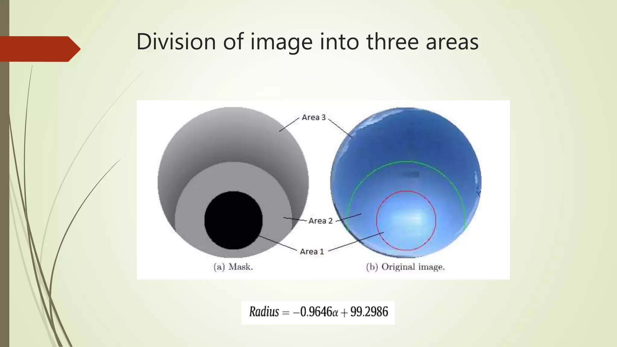
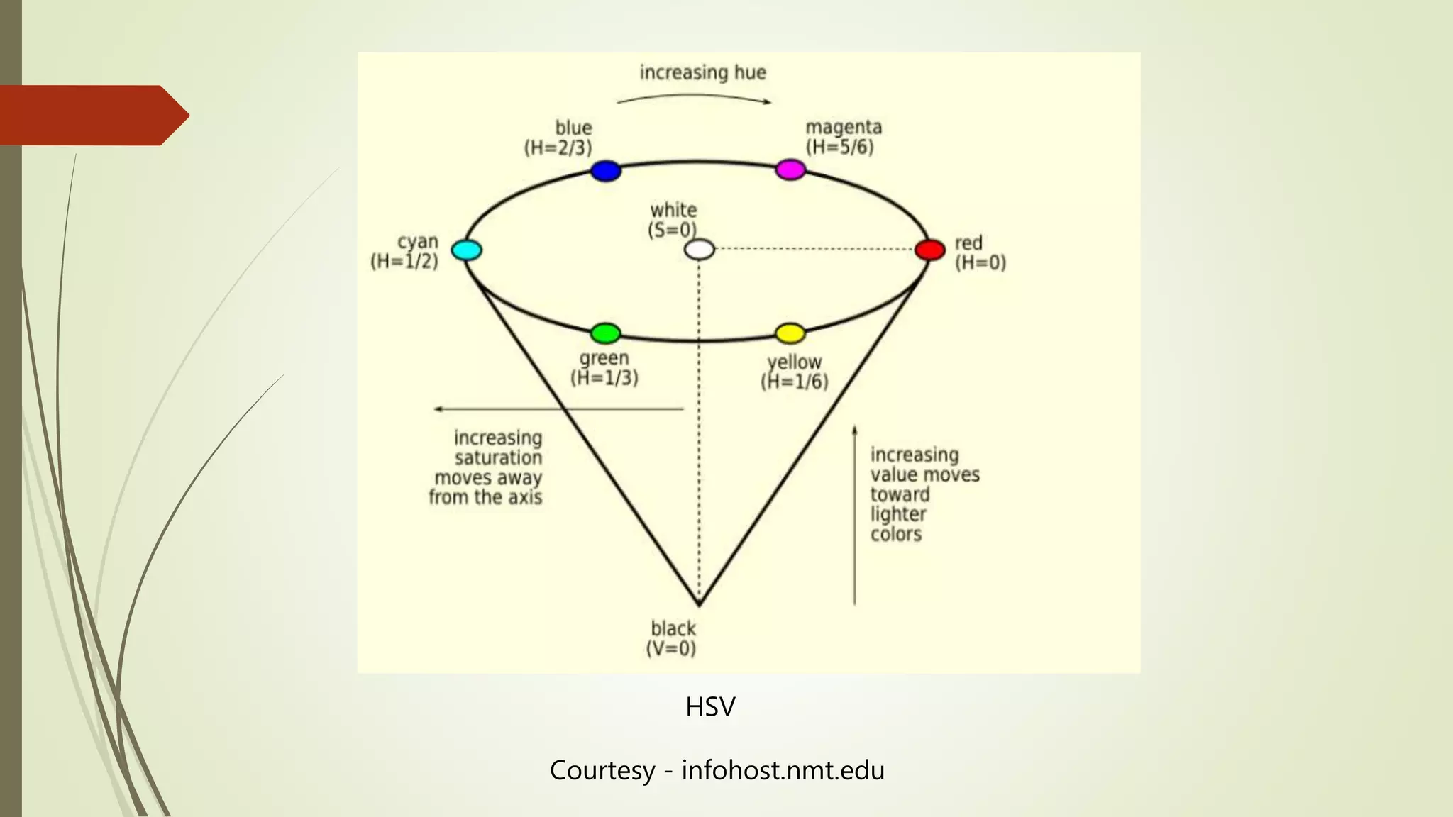
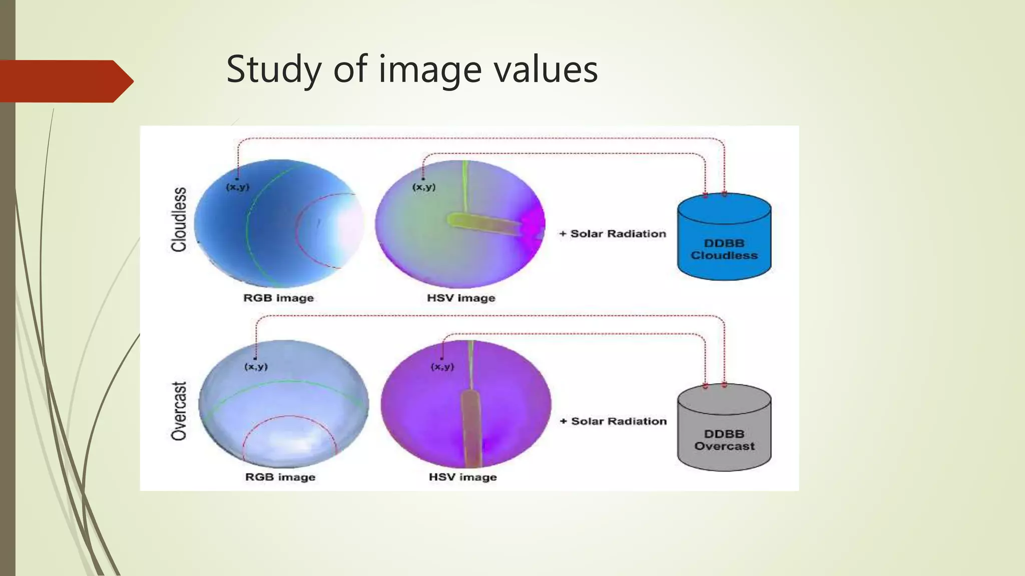
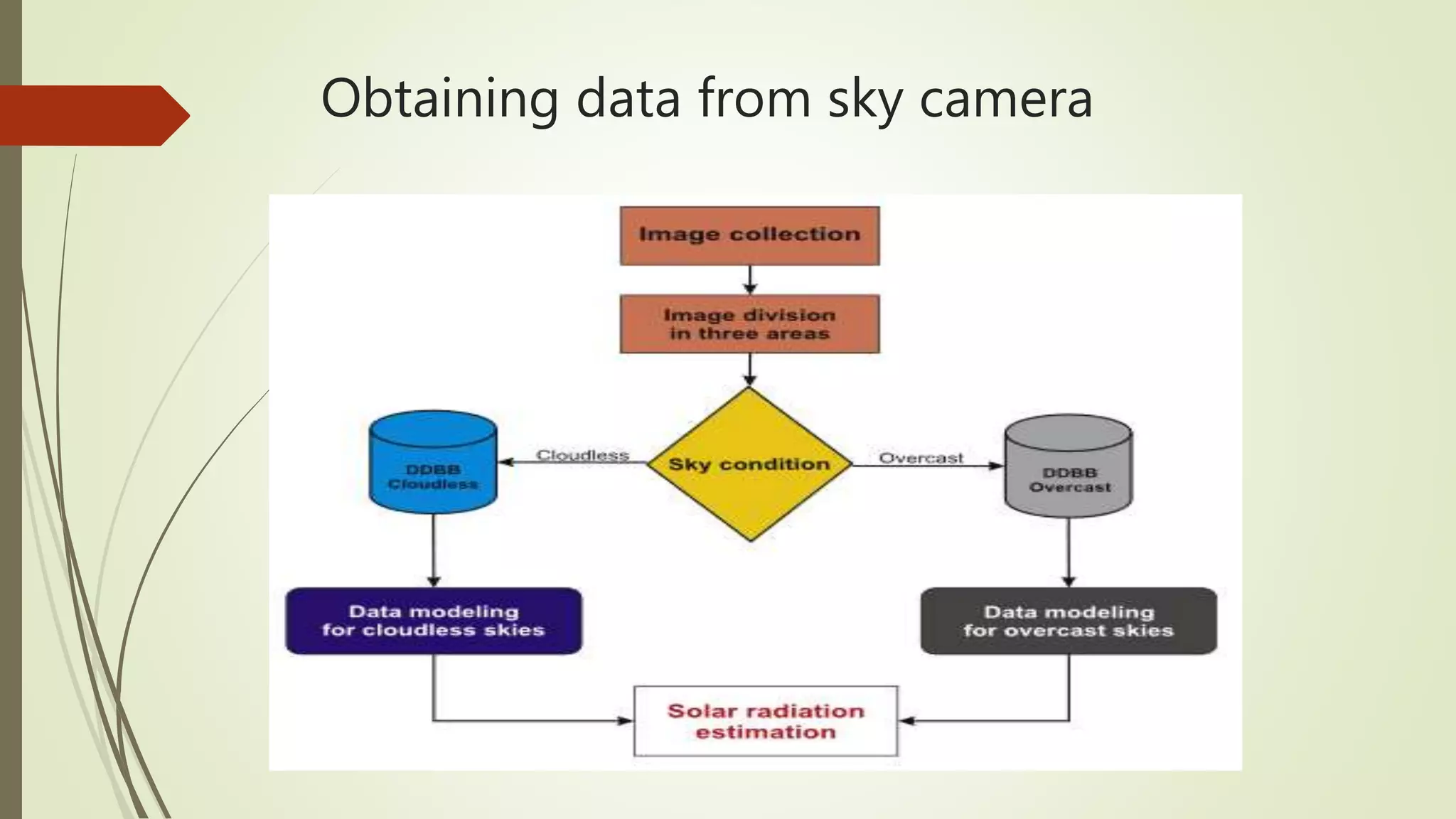
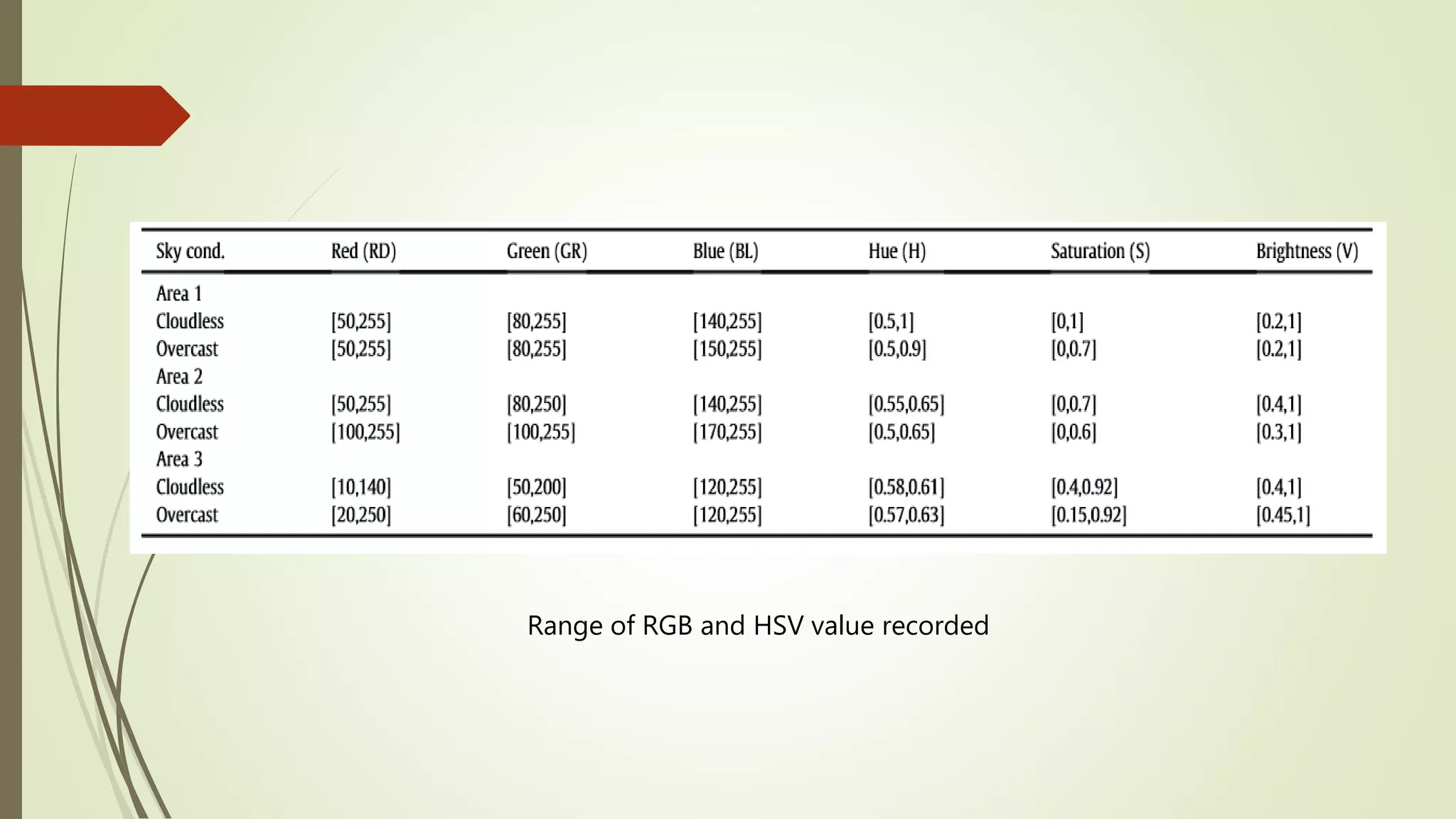
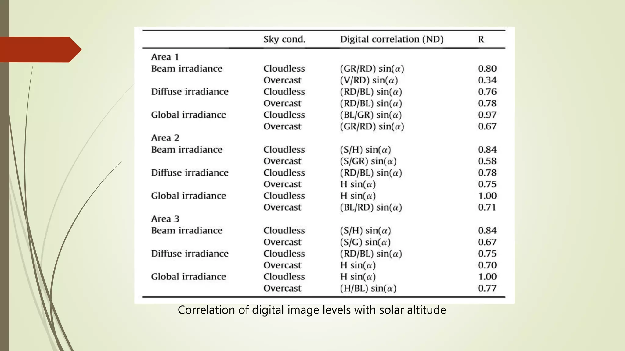
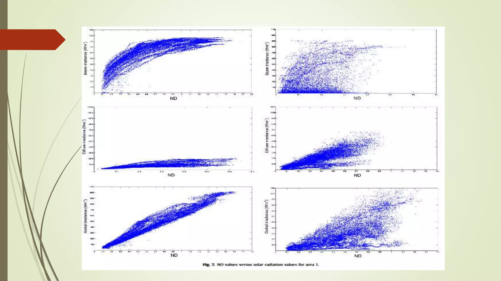
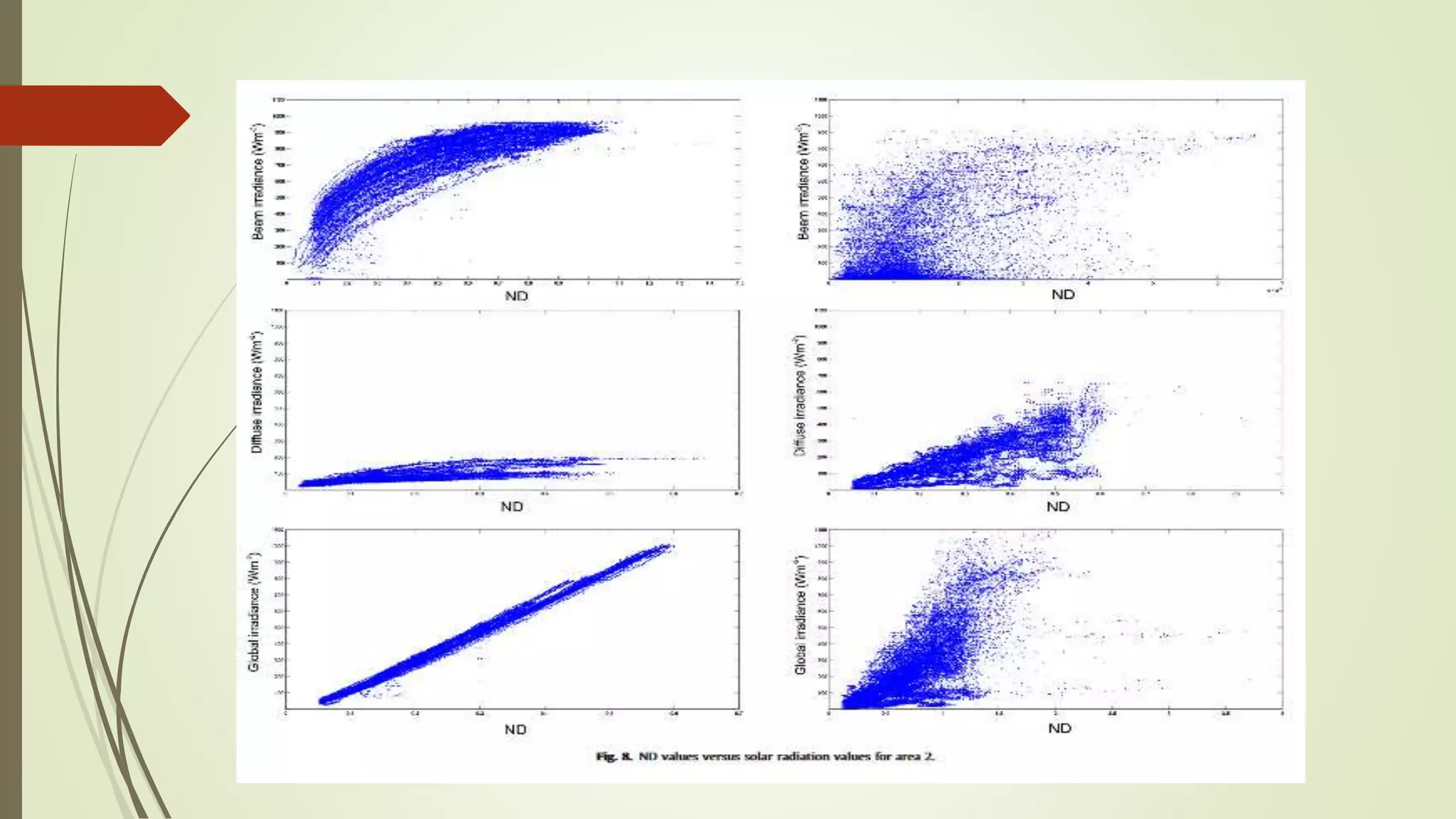
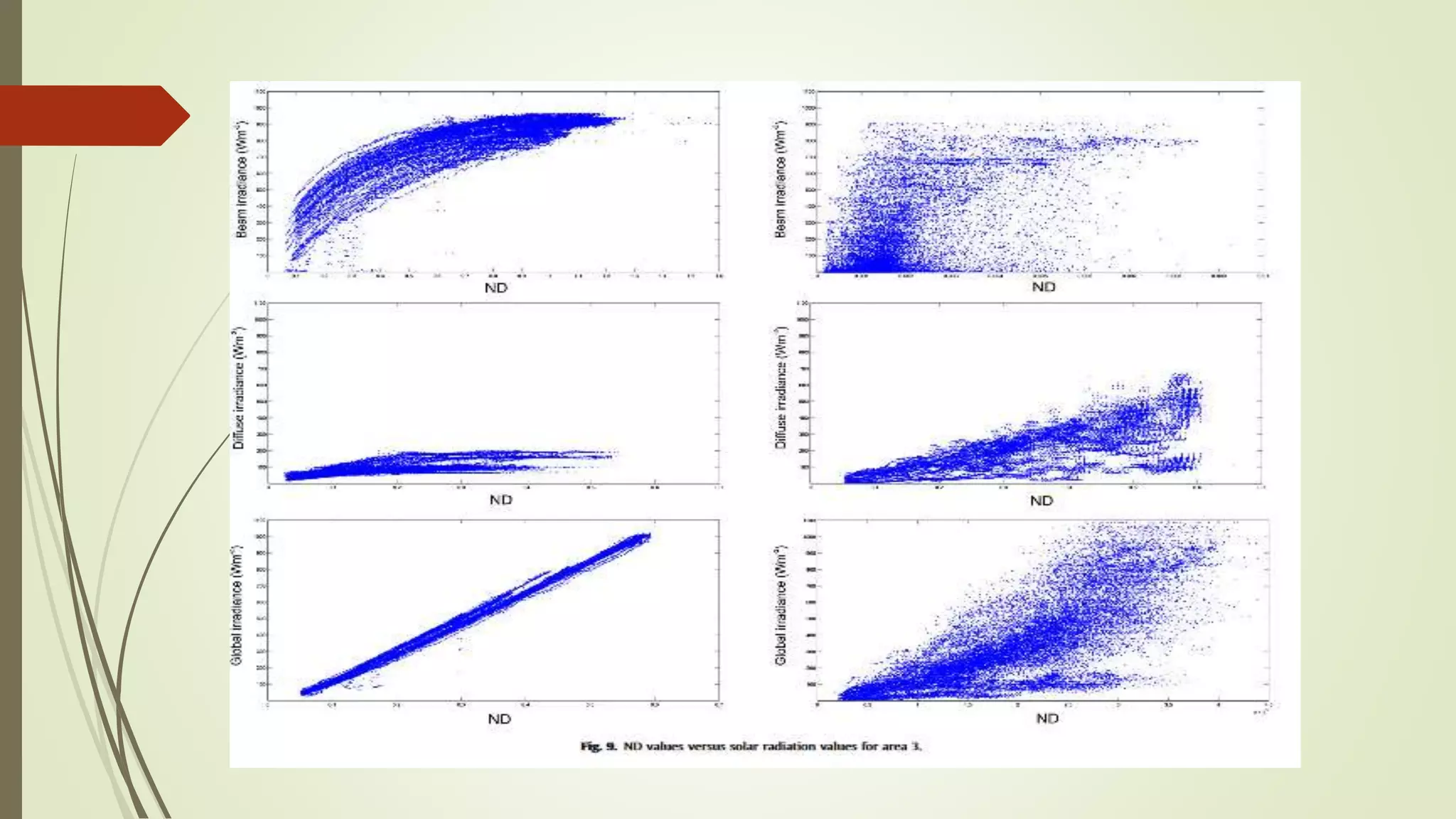
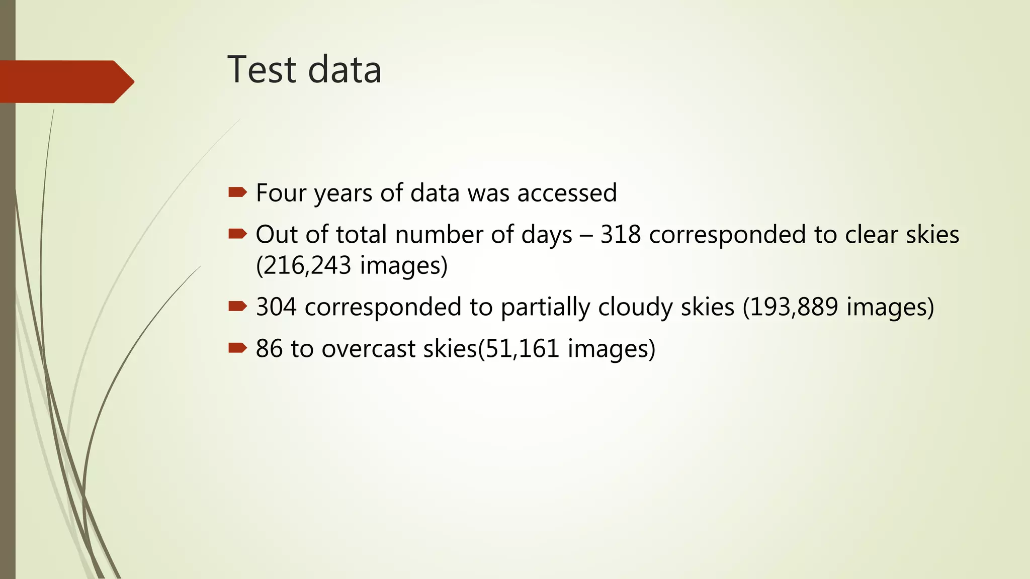
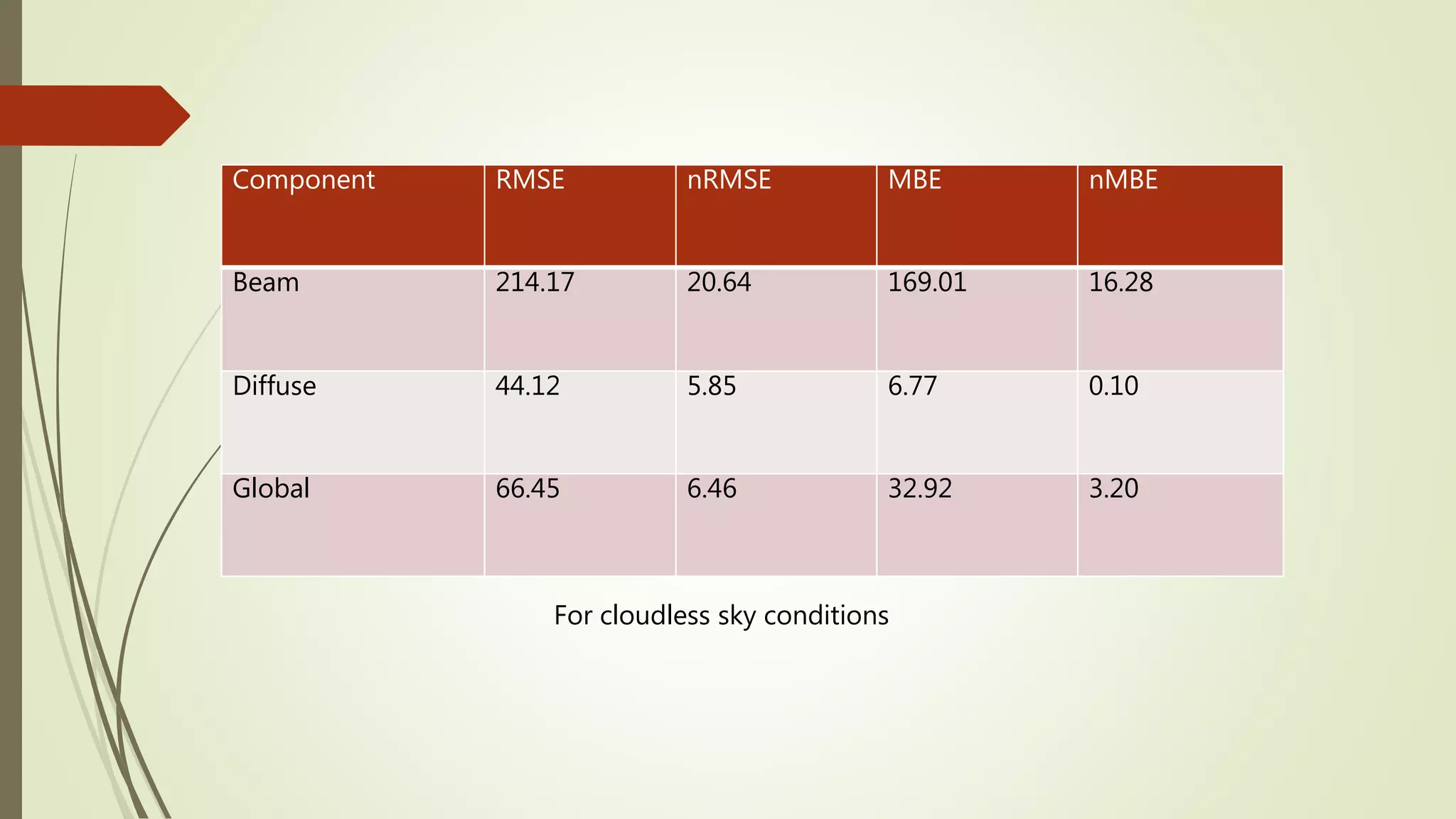
SlideShare a Scribd company logo
Solar Radiation Estimation
based on Digital Image
Processing
HARSH VARDHAN MALL
16EC65R22
Solar Radiation Estimation
 Quantifying the total solar radiation incident in the solar field
 Forecasting cloudy situations.
Why Solar Radiation Estimation?
 Expansion in solar energy applications
 Information of atmospheric conditions is the major
requirement to improve system performance
 Information is used to adapt solar plant's strategic operation
to the meteorological conditions
Components of Solar Radiation
 3 components - Beam, Diffuse and Global Solar Radiation
 Beam Radiation – Solar radiation travelling in a straight line
directly to the surface of the earth
 Diffuse Radiation – Solar radiation reaching the surface after
being scattered by atoms and molecules in atmosphere
 Global Radiation – Total radiation reaching the surface. It
includes both Beam and Diffuse radiation
.
Courtesy –
www.cspalliance.org
Sky Camera
 Sky Camera is used for solar radiation estimation
 Hemispherical vision is represented in JPEG images
 Images collected over 1 minute periods when solar altitude is
higher than 5 degrees
 Dataset made with sky camera images and solar radiation
data
Image taken from sky camera
Courtesy - www.niwa.co.nz
Division of image into three areas
Distance Matrix
Division of image into three areas
 Area around the sun is more saturated and dilutes as we
move away from "Sun pixel"
 This area varies according to the time of the day
 After image splitting, pixel values are studied for cloudless
and overcast situations
 Different databases were created for both situations
 Data of 4 clear and 4 cloud covered days (for each season)
was collected
Study of Image values
 Digital values of RGB(red, green, blue) and HSV(hue,
saturation, value) are collected for each pixel
 Beam, Diffuse and Global solar irradiance values are also
collected for each pixel
 These values are stored at the databases
HSV
Courtesy - infohost.nmt.edu
Study of image values
Obtaining data from sky camera
Range of RGB and HSV value recorded
Channel values based on solar altitude
 Correlation between different image and solar altitude was
analyzed.
 It is done for each type of sky condition and each area
Correlation of digital image levels with solar altitude
Plotting Solar Irradiance
versus ND values
For Beam, Diffuse and Global Solar Radiation Values
Estimation of Solar Radiation components
 Area 1 is considered the most representative in terms of Beam
solar radiation component
 Area 2 and 3 better define the diffuse and global solar
radiation components
 To estimate beam radiation, the values of beam radiation
from pixels of area 1 are averaged
 To estimate diffuse and global radiation, pixels from all three
areas are averaged
Errors
 RMSE (Root Mean Square Error)
 Normalized RMSE (nRMSE)
 MBE (Mean Bias Error)
 Normalizes MBE (nMBE)
Formulae Definitions
Test data
 Four years of data was accessed
 Out of total number of days – 318 corresponded to clear skies
(216,243 images)
 304 corresponded to partially cloudy skies (193,889 images)
 86 to overcast skies(51,161 images)
Component RMSE nRMSE MBE nMBE
Beam 214.17 20.64 169.01 16.28
Diffuse 44.12 5.85 6.77 0.10
Global 66.45 6.46 32.92 3.20
For cloudless sky conditions
Component RMSE nRMSE MBE nMBE
Beam 106.50 11.13 48.97 0.87
Diffuse 122.09 16.31 43.47 0.38
Global 152.72 11.81 55.64 0.66
For overcast sky conditions
References
 J. Alonso-Montesinos, F.J. Batlles "The use of a sky camera for solar
radiation estimation based on digital image processing" Energy
2015;90: Page 377-386
 Escrig H, Batlles FJ, Alonso J, Baena FM, Bosch JL, Salbidegoitia IB, et al.
"Cloud detection, classification and motion estimation using
geostationary satellite imagery for cloud cover forecast." Energy 2013;55
Page 853-859
 Rusen SE, Hammer A, Akinoglu BG. "Estimation of daily global solar
irradiation by coupling ground measurements of bright sunshine hours to
satellite imagery." Energy 2013;58 Page 417-425

More Related Content

What's hot

Meterological Technology International, Nov 2010
Meterological Technology International, Nov 2010Meterological Technology International, Nov 2010
Meterological Technology International, Nov 2010
laurajairam
 
GPS in Planning
GPS in PlanningGPS in Planning
GPS in Planning
KU Leuven
 
3D Cloud Visualizations
3D Cloud Visualizations3D Cloud Visualizations
3D Cloud Visualizations
John Pham
 
GPS
GPS GPS
Integral field spectroscopy
Integral field spectroscopyIntegral field spectroscopy
Integral field spectroscopy
Fernando Reche
 
Coulter_JPL_Poster_Final
Coulter_JPL_Poster_FinalCoulter_JPL_Poster_Final
Coulter_JPL_Poster_Final
Dave Coulter
 
6 g-considering clouds
6 g-considering clouds6 g-considering clouds
6 g-considering clouds
Riccardo Rigon
 
Satellite Mapping
Satellite MappingSatellite Mapping
Satellite Mapping
Pinus57
 
Geothermal exploration using remote sensing techniques
Geothermal exploration using remote sensing techniquesGeothermal exploration using remote sensing techniques
Geothermal exploration using remote sensing techniques
Sepideh Abadpour
 
UST_inquiry_Poster
UST_inquiry_PosterUST_inquiry_Poster
UST_inquiry_Poster
Maria McQuillan
 
Remote sensing
Remote sensingRemote sensing
Remote sensing
Nishant Chaturvedi
 
Remote sensing
Remote sensing Remote sensing
Remote sensing
GouriKadtare
 
Types of stereoscope
Types of stereoscopeTypes of stereoscope
Types of stereoscope
Mr Amol Ghogare
 
Remote sensing
Remote sensingRemote sensing
Operational Data Fusion Framework for Building Frequent Land sat-Like Imagery
Operational Data Fusion Framework for Building Frequent Land sat-Like ImageryOperational Data Fusion Framework for Building Frequent Land sat-Like Imagery
Operational Data Fusion Framework for Building Frequent Land sat-Like Imagery
KaashivInfoTech Company
 
APPLICATION OF REMOTE SENSING AND GIS IN AGRICULTURE
APPLICATION OF REMOTE SENSING AND GIS IN AGRICULTUREAPPLICATION OF REMOTE SENSING AND GIS IN AGRICULTURE
APPLICATION OF REMOTE SENSING AND GIS IN AGRICULTURE
LagnajeetRoy
 
Stereoscopic parallax
Stereoscopic parallaxStereoscopic parallax
Stereoscopic parallax
Mr Amol Ghogare
 
How to use a solar compass to point satellite dish azimu
How to use a solar compass to point satellite dish azimuHow to use a solar compass to point satellite dish azimu
How to use a solar compass to point satellite dish azimu
Tms Ani
 
How to use GPS and GIS in Surveying - Report
How to use GPS and GIS in Surveying - ReportHow to use GPS and GIS in Surveying - Report
How to use GPS and GIS in Surveying - Report
Sarchia Khursheed
 
Remote sensing concept and applications
Remote sensing   concept and applicationsRemote sensing   concept and applications
Remote sensing concept and applications
Megha Majoe
 

What's hot (20)

Meterological Technology International, Nov 2010
Meterological Technology International, Nov 2010Meterological Technology International, Nov 2010
Meterological Technology International, Nov 2010
 
GPS in Planning
GPS in PlanningGPS in Planning
GPS in Planning
 
3D Cloud Visualizations
3D Cloud Visualizations3D Cloud Visualizations
3D Cloud Visualizations
 
GPS
GPS GPS
GPS
 
Integral field spectroscopy
Integral field spectroscopyIntegral field spectroscopy
Integral field spectroscopy
 
Coulter_JPL_Poster_Final
Coulter_JPL_Poster_FinalCoulter_JPL_Poster_Final
Coulter_JPL_Poster_Final
 
6 g-considering clouds
6 g-considering clouds6 g-considering clouds
6 g-considering clouds
 
Satellite Mapping
Satellite MappingSatellite Mapping
Satellite Mapping
 
Geothermal exploration using remote sensing techniques
Geothermal exploration using remote sensing techniquesGeothermal exploration using remote sensing techniques
Geothermal exploration using remote sensing techniques
 
UST_inquiry_Poster
UST_inquiry_PosterUST_inquiry_Poster
UST_inquiry_Poster
 
Remote sensing
Remote sensingRemote sensing
Remote sensing
 
Remote sensing
Remote sensing Remote sensing
Remote sensing
 
Types of stereoscope
Types of stereoscopeTypes of stereoscope
Types of stereoscope
 
Remote sensing
Remote sensingRemote sensing
Remote sensing
 
Operational Data Fusion Framework for Building Frequent Land sat-Like Imagery
Operational Data Fusion Framework for Building Frequent Land sat-Like ImageryOperational Data Fusion Framework for Building Frequent Land sat-Like Imagery
Operational Data Fusion Framework for Building Frequent Land sat-Like Imagery
 
APPLICATION OF REMOTE SENSING AND GIS IN AGRICULTURE
APPLICATION OF REMOTE SENSING AND GIS IN AGRICULTUREAPPLICATION OF REMOTE SENSING AND GIS IN AGRICULTURE
APPLICATION OF REMOTE SENSING AND GIS IN AGRICULTURE
 
Stereoscopic parallax
Stereoscopic parallaxStereoscopic parallax
Stereoscopic parallax
 
How to use a solar compass to point satellite dish azimu
How to use a solar compass to point satellite dish azimuHow to use a solar compass to point satellite dish azimu
How to use a solar compass to point satellite dish azimu
 
How to use GPS and GIS in Surveying - Report
How to use GPS and GIS in Surveying - ReportHow to use GPS and GIS in Surveying - Report
How to use GPS and GIS in Surveying - Report
 
Remote sensing concept and applications
Remote sensing   concept and applicationsRemote sensing   concept and applications
Remote sensing concept and applications
 

Viewers also liked

Gas in a box temperature gradient 1d
Gas in a box temperature gradient 1dGas in a box temperature gradient 1d
Gas in a box temperature gradient 1d
brslides
 
Lawson climate pinatubo
Lawson climate pinatuboLawson climate pinatubo
Lawson climate pinatubo
tylerlawson
 
Chapter 10, Lesson 3 Atmosphere and Air Temperature
Chapter 10, Lesson 3 Atmosphere and Air TemperatureChapter 10, Lesson 3 Atmosphere and Air Temperature
Chapter 10, Lesson 3 Atmosphere and Air Temperature
whitneyhgodfrey
 
Atmospheric humidity
Atmospheric humidityAtmospheric humidity
Atmospheric humidity
rb roonbat
 
Blind detection of image manipulation @ PoliMi
Blind detection of image manipulation @ PoliMiBlind detection of image manipulation @ PoliMi
Blind detection of image manipulation @ PoliMi
Giorgio Sironi
 
Chemtrails
ChemtrailsChemtrails
Chemtrails
John Bergman
 
Solar radiation calculation
Solar radiation calculationSolar radiation calculation
Solar radiation calculation
frengkyagungt
 
Passive techniques for detection of tampering in images by Surbhi Arora and S...
Passive techniques for detection of tampering in images by Surbhi Arora and S...Passive techniques for detection of tampering in images by Surbhi Arora and S...
Passive techniques for detection of tampering in images by Surbhi Arora and S...
arorasurbhi
 
Photo Editing
Photo EditingPhoto Editing
Photo Editing
Jennifer Sheppard
 
Hvac validation protocol
Hvac validation protocolHvac validation protocol
Hvac validation protocol
vivekccpr21
 
01 introduction DIP
01 introduction DIP01 introduction DIP
01 introduction DIP
babak danyal
 
solar thermal energy
solar thermal energysolar thermal energy
solar thermal energy
Gražvydas Kruopys
 
fuzzy image processing
fuzzy image processingfuzzy image processing
fuzzy image processing
amalalhait
 
Fields of digital image processing slides
Fields of digital image processing slidesFields of digital image processing slides
Fields of digital image processing slides
Srinath Dhayalamoorthy
 
Solar Thermal Energy Isabel
Solar Thermal Energy IsabelSolar Thermal Energy Isabel
Solar Thermal Energy Isabel
Rosalmara
 
Image enhancement techniques
Image enhancement techniquesImage enhancement techniques
Image enhancement techniques
Saideep
 
Medical Image Processing
Medical Image ProcessingMedical Image Processing
Medical Image Processing
Pantech ProLabs India Pvt Ltd
 
Image editing
Image editingImage editing
Image editing
gayle_bugayong
 
Weather and Climate
Weather and ClimateWeather and Climate
Weather and Climate
tcooper66
 
Weather & climate 1
Weather & climate   1Weather & climate   1
Weather & climate 1
pjb09138
 

Viewers also liked (20)

Gas in a box temperature gradient 1d
Gas in a box temperature gradient 1dGas in a box temperature gradient 1d
Gas in a box temperature gradient 1d
 
Lawson climate pinatubo
Lawson climate pinatuboLawson climate pinatubo
Lawson climate pinatubo
 
Chapter 10, Lesson 3 Atmosphere and Air Temperature
Chapter 10, Lesson 3 Atmosphere and Air TemperatureChapter 10, Lesson 3 Atmosphere and Air Temperature
Chapter 10, Lesson 3 Atmosphere and Air Temperature
 
Atmospheric humidity
Atmospheric humidityAtmospheric humidity
Atmospheric humidity
 
Blind detection of image manipulation @ PoliMi
Blind detection of image manipulation @ PoliMiBlind detection of image manipulation @ PoliMi
Blind detection of image manipulation @ PoliMi
 
Chemtrails
ChemtrailsChemtrails
Chemtrails
 
Solar radiation calculation
Solar radiation calculationSolar radiation calculation
Solar radiation calculation
 
Passive techniques for detection of tampering in images by Surbhi Arora and S...
Passive techniques for detection of tampering in images by Surbhi Arora and S...Passive techniques for detection of tampering in images by Surbhi Arora and S...
Passive techniques for detection of tampering in images by Surbhi Arora and S...
 
Photo Editing
Photo EditingPhoto Editing
Photo Editing
 
Hvac validation protocol
Hvac validation protocolHvac validation protocol
Hvac validation protocol
 
01 introduction DIP
01 introduction DIP01 introduction DIP
01 introduction DIP
 
solar thermal energy
solar thermal energysolar thermal energy
solar thermal energy
 
fuzzy image processing
fuzzy image processingfuzzy image processing
fuzzy image processing
 
Fields of digital image processing slides
Fields of digital image processing slidesFields of digital image processing slides
Fields of digital image processing slides
 
Solar Thermal Energy Isabel
Solar Thermal Energy IsabelSolar Thermal Energy Isabel
Solar Thermal Energy Isabel
 
Image enhancement techniques
Image enhancement techniquesImage enhancement techniques
Image enhancement techniques
 
Medical Image Processing
Medical Image ProcessingMedical Image Processing
Medical Image Processing
 
Image editing
Image editingImage editing
Image editing
 
Weather and Climate
Weather and ClimateWeather and Climate
Weather and Climate
 
Weather & climate 1
Weather & climate   1Weather & climate   1
Weather & climate 1
 

Similar to Solar Radiation Estimation based on Digital Image Processing

07 big skyearth_dlr_7_april_2016
07 big skyearth_dlr_7_april_201607 big skyearth_dlr_7_april_2016
07 big skyearth_dlr_7_april_2016
Marco Quartulli
 
RE.SUN Validation (March 2013)
RE.SUN Validation (March 2013)RE.SUN Validation (March 2013)
RE.SUN Validation (March 2013)
Carlos Pinto
 
Predictive Analysis of Global Solar Radiation in Awka Using Statistical Error...
Predictive Analysis of Global Solar Radiation in Awka Using Statistical Error...Predictive Analysis of Global Solar Radiation in Awka Using Statistical Error...
Predictive Analysis of Global Solar Radiation in Awka Using Statistical Error...
ijtsrd
 
Typical Meteorological Year Report for CSP, CPV and PV solar plants
Typical Meteorological Year Report for CSP, CPV and PV solar plantsTypical Meteorological Year Report for CSP, CPV and PV solar plants
Typical Meteorological Year Report for CSP, CPV and PV solar plants
IrSOLaV Pomares
 
A PHYSICAL METHOD TO COMPUTE SURFACE RADIATION FROM GEOSTATIONARY SATELLITES
A PHYSICAL METHOD TO COMPUTE SURFACE RADIATION FROM GEOSTATIONARY SATELLITES  A PHYSICAL METHOD TO COMPUTE SURFACE RADIATION FROM GEOSTATIONARY SATELLITES
A PHYSICAL METHOD TO COMPUTE SURFACE RADIATION FROM GEOSTATIONARY SATELLITES
Roberto Valer
 
Basics of remote sensing and GIS.pptx
Basics of remote sensing and GIS.pptxBasics of remote sensing and GIS.pptx
Basics of remote sensing and GIS.pptx
FUCKAGAIN
 
MOD 5 SVIT NOTES VTU SYLLABUS 2018 SCHEME.pdf
MOD 5 SVIT NOTES VTU SYLLABUS 2018 SCHEME.pdfMOD 5 SVIT NOTES VTU SYLLABUS 2018 SCHEME.pdf
MOD 5 SVIT NOTES VTU SYLLABUS 2018 SCHEME.pdf
BhuvanaN12
 
D04722440
D04722440D04722440
D04722440
IOSR-JEN
 
2004-10-03 Co-retrieval of Aerosol and Surface Reflectance: Analysis of Daily...
2004-10-03 Co-retrieval of Aerosol and Surface Reflectance: Analysis of Daily...2004-10-03 Co-retrieval of Aerosol and Surface Reflectance: Analysis of Daily...
2004-10-03 Co-retrieval of Aerosol and Surface Reflectance: Analysis of Daily...
Rudolf Husar
 
0421026 Visib Satellite
0421026 Visib Satellite0421026 Visib Satellite
0421026 Visib Satellite
Rudolf Husar
 
2004-10-03 Co-retrieval of Aerosol and Surface Reflectance: Analysis of Daily...
2004-10-03 Co-retrieval of Aerosol and Surface Reflectance: Analysis of Daily...2004-10-03 Co-retrieval of Aerosol and Surface Reflectance: Analysis of Daily...
2004-10-03 Co-retrieval of Aerosol and Surface Reflectance: Analysis of Daily...
Rudolf Husar
 
Feature Extraction from the Satellite Image Gray Color and Knowledge Discove...
Feature Extraction from the Satellite Image Gray Color and  Knowledge Discove...Feature Extraction from the Satellite Image Gray Color and  Knowledge Discove...
Feature Extraction from the Satellite Image Gray Color and Knowledge Discove...
IJMER
 
MODELING DAILY NET SHORTWAVE RADIATION OVER RUGGED SURFACES USING MODIS ATMOS...
MODELING DAILY NET SHORTWAVE RADIATION OVER RUGGED SURFACES USING MODIS ATMOS...MODELING DAILY NET SHORTWAVE RADIATION OVER RUGGED SURFACES USING MODIS ATMOS...
MODELING DAILY NET SHORTWAVE RADIATION OVER RUGGED SURFACES USING MODIS ATMOS...
grssieee
 
MODELING DAILY NET SHORTWAVE RADIATION OVER RUGGED SURFACES USING MODIS ATMOS...
MODELING DAILY NET SHORTWAVE RADIATION OVER RUGGED SURFACES USING MODIS ATMOS...MODELING DAILY NET SHORTWAVE RADIATION OVER RUGGED SURFACES USING MODIS ATMOS...
MODELING DAILY NET SHORTWAVE RADIATION OVER RUGGED SURFACES USING MODIS ATMOS...
grssieee
 
Atmospheric Correction of Remotely Sensed Images in Spatial and Transform Domain
Atmospheric Correction of Remotely Sensed Images in Spatial and Transform DomainAtmospheric Correction of Remotely Sensed Images in Spatial and Transform Domain
Atmospheric Correction of Remotely Sensed Images in Spatial and Transform Domain
CSCJournals
 
Measuring Solar Spectral Energy
Measuring Solar Spectral EnergyMeasuring Solar Spectral Energy
Measuring Solar Spectral Energy
Betsy Kenaston
 
Reanalysis Datasets for Solar Resource Assessment - 2014 SPI
Reanalysis Datasets for Solar Resource Assessment - 2014 SPI Reanalysis Datasets for Solar Resource Assessment - 2014 SPI
Reanalysis Datasets for Solar Resource Assessment - 2014 SPI
Gwendalyn Bender
 
G044044249
G044044249G044044249
G044044249
IJERA Editor
 
AIAA Paper dlt228
AIAA Paper dlt228AIAA Paper dlt228
AIAA Paper dlt228
Dwight Temple
 
Synthetic aperture radar
Synthetic aperture radarSynthetic aperture radar
Synthetic aperture radar
Mahesh pawar
 

Similar to Solar Radiation Estimation based on Digital Image Processing (20)

07 big skyearth_dlr_7_april_2016
07 big skyearth_dlr_7_april_201607 big skyearth_dlr_7_april_2016
07 big skyearth_dlr_7_april_2016
 
RE.SUN Validation (March 2013)
RE.SUN Validation (March 2013)RE.SUN Validation (March 2013)
RE.SUN Validation (March 2013)
 
Predictive Analysis of Global Solar Radiation in Awka Using Statistical Error...
Predictive Analysis of Global Solar Radiation in Awka Using Statistical Error...Predictive Analysis of Global Solar Radiation in Awka Using Statistical Error...
Predictive Analysis of Global Solar Radiation in Awka Using Statistical Error...
 
Typical Meteorological Year Report for CSP, CPV and PV solar plants
Typical Meteorological Year Report for CSP, CPV and PV solar plantsTypical Meteorological Year Report for CSP, CPV and PV solar plants
Typical Meteorological Year Report for CSP, CPV and PV solar plants
 
A PHYSICAL METHOD TO COMPUTE SURFACE RADIATION FROM GEOSTATIONARY SATELLITES
A PHYSICAL METHOD TO COMPUTE SURFACE RADIATION FROM GEOSTATIONARY SATELLITES  A PHYSICAL METHOD TO COMPUTE SURFACE RADIATION FROM GEOSTATIONARY SATELLITES
A PHYSICAL METHOD TO COMPUTE SURFACE RADIATION FROM GEOSTATIONARY SATELLITES
 
Basics of remote sensing and GIS.pptx
Basics of remote sensing and GIS.pptxBasics of remote sensing and GIS.pptx
Basics of remote sensing and GIS.pptx
 
MOD 5 SVIT NOTES VTU SYLLABUS 2018 SCHEME.pdf
MOD 5 SVIT NOTES VTU SYLLABUS 2018 SCHEME.pdfMOD 5 SVIT NOTES VTU SYLLABUS 2018 SCHEME.pdf
MOD 5 SVIT NOTES VTU SYLLABUS 2018 SCHEME.pdf
 
D04722440
D04722440D04722440
D04722440
 
2004-10-03 Co-retrieval of Aerosol and Surface Reflectance: Analysis of Daily...
2004-10-03 Co-retrieval of Aerosol and Surface Reflectance: Analysis of Daily...2004-10-03 Co-retrieval of Aerosol and Surface Reflectance: Analysis of Daily...
2004-10-03 Co-retrieval of Aerosol and Surface Reflectance: Analysis of Daily...
 
0421026 Visib Satellite
0421026 Visib Satellite0421026 Visib Satellite
0421026 Visib Satellite
 
2004-10-03 Co-retrieval of Aerosol and Surface Reflectance: Analysis of Daily...
2004-10-03 Co-retrieval of Aerosol and Surface Reflectance: Analysis of Daily...2004-10-03 Co-retrieval of Aerosol and Surface Reflectance: Analysis of Daily...
2004-10-03 Co-retrieval of Aerosol and Surface Reflectance: Analysis of Daily...
 
Feature Extraction from the Satellite Image Gray Color and Knowledge Discove...
Feature Extraction from the Satellite Image Gray Color and  Knowledge Discove...Feature Extraction from the Satellite Image Gray Color and  Knowledge Discove...
Feature Extraction from the Satellite Image Gray Color and Knowledge Discove...
 
MODELING DAILY NET SHORTWAVE RADIATION OVER RUGGED SURFACES USING MODIS ATMOS...
MODELING DAILY NET SHORTWAVE RADIATION OVER RUGGED SURFACES USING MODIS ATMOS...MODELING DAILY NET SHORTWAVE RADIATION OVER RUGGED SURFACES USING MODIS ATMOS...
MODELING DAILY NET SHORTWAVE RADIATION OVER RUGGED SURFACES USING MODIS ATMOS...
 
MODELING DAILY NET SHORTWAVE RADIATION OVER RUGGED SURFACES USING MODIS ATMOS...
MODELING DAILY NET SHORTWAVE RADIATION OVER RUGGED SURFACES USING MODIS ATMOS...MODELING DAILY NET SHORTWAVE RADIATION OVER RUGGED SURFACES USING MODIS ATMOS...
MODELING DAILY NET SHORTWAVE RADIATION OVER RUGGED SURFACES USING MODIS ATMOS...
 
Atmospheric Correction of Remotely Sensed Images in Spatial and Transform Domain
Atmospheric Correction of Remotely Sensed Images in Spatial and Transform DomainAtmospheric Correction of Remotely Sensed Images in Spatial and Transform Domain
Atmospheric Correction of Remotely Sensed Images in Spatial and Transform Domain
 
Measuring Solar Spectral Energy
Measuring Solar Spectral EnergyMeasuring Solar Spectral Energy
Measuring Solar Spectral Energy
 
Reanalysis Datasets for Solar Resource Assessment - 2014 SPI
Reanalysis Datasets for Solar Resource Assessment - 2014 SPI Reanalysis Datasets for Solar Resource Assessment - 2014 SPI
Reanalysis Datasets for Solar Resource Assessment - 2014 SPI
 
G044044249
G044044249G044044249
G044044249
 
AIAA Paper dlt228
AIAA Paper dlt228AIAA Paper dlt228
AIAA Paper dlt228
 
Synthetic aperture radar
Synthetic aperture radarSynthetic aperture radar
Synthetic aperture radar
 

Recently uploaded

International Conference on NLP, Artificial Intelligence, Machine Learning an...
International Conference on NLP, Artificial Intelligence, Machine Learning an...International Conference on NLP, Artificial Intelligence, Machine Learning an...
International Conference on NLP, Artificial Intelligence, Machine Learning an...
gerogepatton
 
5214-1693458878915-Unit 6 2023 to 2024 academic year assignment (AutoRecovere...
5214-1693458878915-Unit 6 2023 to 2024 academic year assignment (AutoRecovere...5214-1693458878915-Unit 6 2023 to 2024 academic year assignment (AutoRecovere...
5214-1693458878915-Unit 6 2023 to 2024 academic year assignment (AutoRecovere...
ihlasbinance2003
 
132/33KV substation case study Presentation
132/33KV substation case study Presentation132/33KV substation case study Presentation
132/33KV substation case study Presentation
kandramariana6
 
Literature Review Basics and Understanding Reference Management.pptx
Literature Review Basics and Understanding Reference Management.pptxLiterature Review Basics and Understanding Reference Management.pptx
Literature Review Basics and Understanding Reference Management.pptx
Dr Ramhari Poudyal
 
Unit-III-ELECTROCHEMICAL STORAGE DEVICES.ppt
Unit-III-ELECTROCHEMICAL STORAGE DEVICES.pptUnit-III-ELECTROCHEMICAL STORAGE DEVICES.ppt
Unit-III-ELECTROCHEMICAL STORAGE DEVICES.ppt
KrishnaveniKrishnara1
 
CHINA’S GEO-ECONOMIC OUTREACH IN CENTRAL ASIAN COUNTRIES AND FUTURE PROSPECT
CHINA’S GEO-ECONOMIC OUTREACH IN CENTRAL ASIAN COUNTRIES AND FUTURE PROSPECTCHINA’S GEO-ECONOMIC OUTREACH IN CENTRAL ASIAN COUNTRIES AND FUTURE PROSPECT
CHINA’S GEO-ECONOMIC OUTREACH IN CENTRAL ASIAN COUNTRIES AND FUTURE PROSPECT
jpsjournal1
 
Optimizing Gradle Builds - Gradle DPE Tour Berlin 2024
Optimizing Gradle Builds - Gradle DPE Tour Berlin 2024Optimizing Gradle Builds - Gradle DPE Tour Berlin 2024
Optimizing Gradle Builds - Gradle DPE Tour Berlin 2024
Sinan KOZAK
 
ML Based Model for NIDS MSc Updated Presentation.v2.pptx
ML Based Model for NIDS MSc Updated Presentation.v2.pptxML Based Model for NIDS MSc Updated Presentation.v2.pptx
ML Based Model for NIDS MSc Updated Presentation.v2.pptx
JamalHussainArman
 
Engineering Drawings Lecture Detail Drawings 2014.pdf
Engineering Drawings Lecture Detail Drawings 2014.pdfEngineering Drawings Lecture Detail Drawings 2014.pdf
Engineering Drawings Lecture Detail Drawings 2014.pdf
abbyasa1014
 
Comparative analysis between traditional aquaponics and reconstructed aquapon...
Comparative analysis between traditional aquaponics and reconstructed aquapon...Comparative analysis between traditional aquaponics and reconstructed aquapon...
Comparative analysis between traditional aquaponics and reconstructed aquapon...
bijceesjournal
 
Heat Resistant Concrete Presentation ppt
Heat Resistant Concrete Presentation pptHeat Resistant Concrete Presentation ppt
Heat Resistant Concrete Presentation ppt
mamunhossenbd75
 
ACEP Magazine edition 4th launched on 05.06.2024
ACEP Magazine edition 4th launched on 05.06.2024ACEP Magazine edition 4th launched on 05.06.2024
ACEP Magazine edition 4th launched on 05.06.2024
Rahul
 
Properties Railway Sleepers and Test.pptx
Properties Railway Sleepers and Test.pptxProperties Railway Sleepers and Test.pptx
Properties Railway Sleepers and Test.pptx
MDSABBIROJJAMANPAYEL
 
ISPM 15 Heat Treated Wood Stamps and why your shipping must have one
ISPM 15 Heat Treated Wood Stamps and why your shipping must have oneISPM 15 Heat Treated Wood Stamps and why your shipping must have one
ISPM 15 Heat Treated Wood Stamps and why your shipping must have one
Las Vegas Warehouse
 
The Python for beginners. This is an advance computer language.
The Python for beginners. This is an advance computer language.The Python for beginners. This is an advance computer language.
The Python for beginners. This is an advance computer language.
sachin chaurasia
 
CSM Cloud Service Management Presentarion
CSM Cloud Service Management PresentarionCSM Cloud Service Management Presentarion
CSM Cloud Service Management Presentarion
rpskprasana
 
2008 BUILDING CONSTRUCTION Illustrated - Ching Chapter 02 The Building.pdf
2008 BUILDING CONSTRUCTION Illustrated - Ching Chapter 02 The Building.pdf2008 BUILDING CONSTRUCTION Illustrated - Ching Chapter 02 The Building.pdf
2008 BUILDING CONSTRUCTION Illustrated - Ching Chapter 02 The Building.pdf
Yasser Mahgoub
 
basic-wireline-operations-course-mahmoud-f-radwan.pdf
basic-wireline-operations-course-mahmoud-f-radwan.pdfbasic-wireline-operations-course-mahmoud-f-radwan.pdf
basic-wireline-operations-course-mahmoud-f-radwan.pdf
NidhalKahouli2
 
Engine Lubrication performance System.pdf
Engine Lubrication performance System.pdfEngine Lubrication performance System.pdf
Engine Lubrication performance System.pdf
mamamaam477
 
Iron and Steel Technology Roadmap - Towards more sustainable steelmaking.pdf
Iron and Steel Technology Roadmap - Towards more sustainable steelmaking.pdfIron and Steel Technology Roadmap - Towards more sustainable steelmaking.pdf
Iron and Steel Technology Roadmap - Towards more sustainable steelmaking.pdf
RadiNasr
 

Recently uploaded (20)

International Conference on NLP, Artificial Intelligence, Machine Learning an...
International Conference on NLP, Artificial Intelligence, Machine Learning an...International Conference on NLP, Artificial Intelligence, Machine Learning an...
International Conference on NLP, Artificial Intelligence, Machine Learning an...
 
5214-1693458878915-Unit 6 2023 to 2024 academic year assignment (AutoRecovere...
5214-1693458878915-Unit 6 2023 to 2024 academic year assignment (AutoRecovere...5214-1693458878915-Unit 6 2023 to 2024 academic year assignment (AutoRecovere...
5214-1693458878915-Unit 6 2023 to 2024 academic year assignment (AutoRecovere...
 
132/33KV substation case study Presentation
132/33KV substation case study Presentation132/33KV substation case study Presentation
132/33KV substation case study Presentation
 
Literature Review Basics and Understanding Reference Management.pptx
Literature Review Basics and Understanding Reference Management.pptxLiterature Review Basics and Understanding Reference Management.pptx
Literature Review Basics and Understanding Reference Management.pptx
 
Unit-III-ELECTROCHEMICAL STORAGE DEVICES.ppt
Unit-III-ELECTROCHEMICAL STORAGE DEVICES.pptUnit-III-ELECTROCHEMICAL STORAGE DEVICES.ppt
Unit-III-ELECTROCHEMICAL STORAGE DEVICES.ppt
 
CHINA’S GEO-ECONOMIC OUTREACH IN CENTRAL ASIAN COUNTRIES AND FUTURE PROSPECT
CHINA’S GEO-ECONOMIC OUTREACH IN CENTRAL ASIAN COUNTRIES AND FUTURE PROSPECTCHINA’S GEO-ECONOMIC OUTREACH IN CENTRAL ASIAN COUNTRIES AND FUTURE PROSPECT
CHINA’S GEO-ECONOMIC OUTREACH IN CENTRAL ASIAN COUNTRIES AND FUTURE PROSPECT
 
Optimizing Gradle Builds - Gradle DPE Tour Berlin 2024
Optimizing Gradle Builds - Gradle DPE Tour Berlin 2024Optimizing Gradle Builds - Gradle DPE Tour Berlin 2024
Optimizing Gradle Builds - Gradle DPE Tour Berlin 2024
 
ML Based Model for NIDS MSc Updated Presentation.v2.pptx
ML Based Model for NIDS MSc Updated Presentation.v2.pptxML Based Model for NIDS MSc Updated Presentation.v2.pptx
ML Based Model for NIDS MSc Updated Presentation.v2.pptx
 
Engineering Drawings Lecture Detail Drawings 2014.pdf
Engineering Drawings Lecture Detail Drawings 2014.pdfEngineering Drawings Lecture Detail Drawings 2014.pdf
Engineering Drawings Lecture Detail Drawings 2014.pdf
 
Comparative analysis between traditional aquaponics and reconstructed aquapon...
Comparative analysis between traditional aquaponics and reconstructed aquapon...Comparative analysis between traditional aquaponics and reconstructed aquapon...
Comparative analysis between traditional aquaponics and reconstructed aquapon...
 
Heat Resistant Concrete Presentation ppt
Heat Resistant Concrete Presentation pptHeat Resistant Concrete Presentation ppt
Heat Resistant Concrete Presentation ppt
 
ACEP Magazine edition 4th launched on 05.06.2024
ACEP Magazine edition 4th launched on 05.06.2024ACEP Magazine edition 4th launched on 05.06.2024
ACEP Magazine edition 4th launched on 05.06.2024
 
Properties Railway Sleepers and Test.pptx
Properties Railway Sleepers and Test.pptxProperties Railway Sleepers and Test.pptx
Properties Railway Sleepers and Test.pptx
 
ISPM 15 Heat Treated Wood Stamps and why your shipping must have one
ISPM 15 Heat Treated Wood Stamps and why your shipping must have oneISPM 15 Heat Treated Wood Stamps and why your shipping must have one
ISPM 15 Heat Treated Wood Stamps and why your shipping must have one
 
The Python for beginners. This is an advance computer language.
The Python for beginners. This is an advance computer language.The Python for beginners. This is an advance computer language.
The Python for beginners. This is an advance computer language.
 
CSM Cloud Service Management Presentarion
CSM Cloud Service Management PresentarionCSM Cloud Service Management Presentarion
CSM Cloud Service Management Presentarion
 
2008 BUILDING CONSTRUCTION Illustrated - Ching Chapter 02 The Building.pdf
2008 BUILDING CONSTRUCTION Illustrated - Ching Chapter 02 The Building.pdf2008 BUILDING CONSTRUCTION Illustrated - Ching Chapter 02 The Building.pdf
2008 BUILDING CONSTRUCTION Illustrated - Ching Chapter 02 The Building.pdf
 
basic-wireline-operations-course-mahmoud-f-radwan.pdf
basic-wireline-operations-course-mahmoud-f-radwan.pdfbasic-wireline-operations-course-mahmoud-f-radwan.pdf
basic-wireline-operations-course-mahmoud-f-radwan.pdf
 
Engine Lubrication performance System.pdf
Engine Lubrication performance System.pdfEngine Lubrication performance System.pdf
Engine Lubrication performance System.pdf
 
Iron and Steel Technology Roadmap - Towards more sustainable steelmaking.pdf
Iron and Steel Technology Roadmap - Towards more sustainable steelmaking.pdfIron and Steel Technology Roadmap - Towards more sustainable steelmaking.pdf
Iron and Steel Technology Roadmap - Towards more sustainable steelmaking.pdf
 

Solar Radiation Estimation based on Digital Image Processing

  • 1. Solar Radiation Estimation based on Digital Image Processing HARSH VARDHAN MALL 16EC65R22
  • 2. Solar Radiation Estimation  Quantifying the total solar radiation incident in the solar field  Forecasting cloudy situations.
  • 3. Why Solar Radiation Estimation?  Expansion in solar energy applications  Information of atmospheric conditions is the major requirement to improve system performance  Information is used to adapt solar plant's strategic operation to the meteorological conditions
  • 4. Components of Solar Radiation  3 components - Beam, Diffuse and Global Solar Radiation  Beam Radiation – Solar radiation travelling in a straight line directly to the surface of the earth  Diffuse Radiation – Solar radiation reaching the surface after being scattered by atoms and molecules in atmosphere  Global Radiation – Total radiation reaching the surface. It includes both Beam and Diffuse radiation
  • 6. Sky Camera  Sky Camera is used for solar radiation estimation  Hemispherical vision is represented in JPEG images  Images collected over 1 minute periods when solar altitude is higher than 5 degrees  Dataset made with sky camera images and solar radiation data
  • 7. Image taken from sky camera Courtesy - www.niwa.co.nz
  • 8. Division of image into three areas Distance Matrix
  • 9. Division of image into three areas
  • 10. Division of image into three areas  Area around the sun is more saturated and dilutes as we move away from "Sun pixel"  This area varies according to the time of the day  After image splitting, pixel values are studied for cloudless and overcast situations  Different databases were created for both situations  Data of 4 clear and 4 cloud covered days (for each season) was collected
  • 11. Study of Image values  Digital values of RGB(red, green, blue) and HSV(hue, saturation, value) are collected for each pixel  Beam, Diffuse and Global solar irradiance values are also collected for each pixel  These values are stored at the databases
  • 13. Study of image values
  • 14. Obtaining data from sky camera
  • 15. Range of RGB and HSV value recorded
  • 16. Channel values based on solar altitude  Correlation between different image and solar altitude was analyzed.  It is done for each type of sky condition and each area
  • 17. Correlation of digital image levels with solar altitude
  • 18. Plotting Solar Irradiance versus ND values For Beam, Diffuse and Global Solar Radiation Values
  • 19.
  • 20.
  • 21.
  • 22. Estimation of Solar Radiation components  Area 1 is considered the most representative in terms of Beam solar radiation component  Area 2 and 3 better define the diffuse and global solar radiation components  To estimate beam radiation, the values of beam radiation from pixels of area 1 are averaged  To estimate diffuse and global radiation, pixels from all three areas are averaged
  • 23. Errors  RMSE (Root Mean Square Error)  Normalized RMSE (nRMSE)  MBE (Mean Bias Error)  Normalizes MBE (nMBE)
  • 25. Test data  Four years of data was accessed  Out of total number of days – 318 corresponded to clear skies (216,243 images)  304 corresponded to partially cloudy skies (193,889 images)  86 to overcast skies(51,161 images)
  • 26. Component RMSE nRMSE MBE nMBE Beam 214.17 20.64 169.01 16.28 Diffuse 44.12 5.85 6.77 0.10 Global 66.45 6.46 32.92 3.20 For cloudless sky conditions
  • 27. Component RMSE nRMSE MBE nMBE Beam 106.50 11.13 48.97 0.87 Diffuse 122.09 16.31 43.47 0.38 Global 152.72 11.81 55.64 0.66 For overcast sky conditions
  • 28. References  J. Alonso-Montesinos, F.J. Batlles "The use of a sky camera for solar radiation estimation based on digital image processing" Energy 2015;90: Page 377-386  Escrig H, Batlles FJ, Alonso J, Baena FM, Bosch JL, Salbidegoitia IB, et al. "Cloud detection, classification and motion estimation using geostationary satellite imagery for cloud cover forecast." Energy 2013;55 Page 853-859  Rusen SE, Hammer A, Akinoglu BG. "Estimation of daily global solar irradiation by coupling ground measurements of bright sunshine hours to satellite imagery." Energy 2013;58 Page 417-425