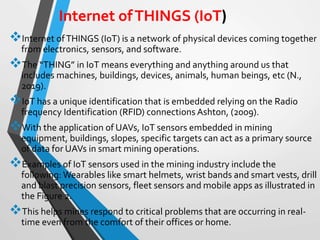
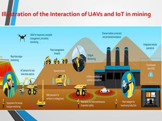
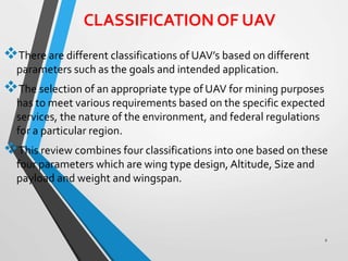
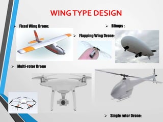
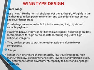
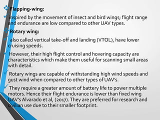
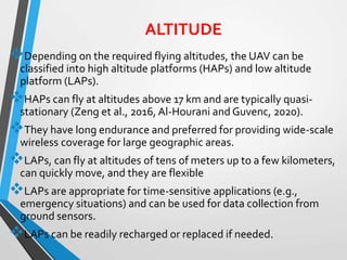
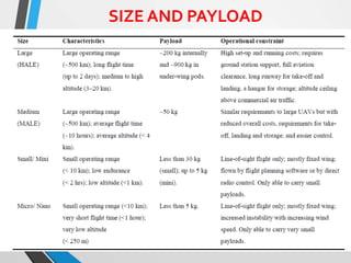
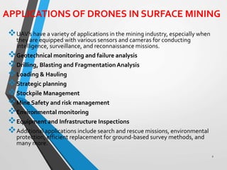
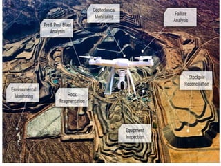
SlideShare a Scribd company logo
2021 ENGINEERING INSTITUTION OF ZAMBIA
SYMPOSIUM
SMART MINING THROUGH THE
APPLICATION OF UAV AND INTERNET
OF THINGS
PRESENTER : Ebelia Manda
DATE : Friday 15th April 2021
Avani Victoria Falls Resort, Livingstone,
Zambia
TABLE OF CONTENTS
1
 1. INTRODUCTION
 2. OVERVIEW OF UAVs AND IoT
 3. CLASSIFICATION OF UAV
 4. APPLICATIONS OF DRONES IN SURFACE MINING
 5. DISCUSSION
 6. CONCLUSION
 7. REFERENCES
INTRODUCTION
The COVID-19 pandemic has shown its potential to create
devastating social, economic and political challenges that will
have lasting repercussions (World Economic Forum, 2020).
It has affected the commodity markets in a variety of ways and
the demand for many commodities remain low with a lower near-
term demand on the horizon (Deloitte, 2021).
Company operations have been affected through isolated
outbreaks, some employees working from home and government
mandated shutdowns.
To positively respond to this crisis, mining industries have to
transform and adjust to smart mining operations through the
application of Unmanned AerialVehicles (UAVs) and Internet of
Things (IoT) technologies.
2
Smart mining is mining using latest technologies to enhance high
efficiency in production, safety management, sustainable exploitation of
mineral resources, effective communication, environmental monitoring
and protection, real time monitoring of mining operations, cost reduction
and timely decision making.
The rapid technological development and mature application of UAV and
IoT technology makes it possible to obtain the operation progress of the
mine, through the link connection relationship and the operation of the
equipment from a high altitude where the presence of humans is difficult,
impossible, or dangerous.
The application of UAV and IoT technologies can establish a visual
production interactive management and emergency command system
which is of great significance to improve the production management level
and emergency response capabilities of open-pit and underground mines,
control production costs, and keep up with the forefront of high-tech
development.
The focus of this research is the application of UAVs and IoT in the mining
industry, highlighting the different types of UAVs and IoTs, their
classification, application in the surface mines, advantages and
disadvantages
OVERVIEW OF UAVs AND IoT
An Unmanned AerialVehicle (UAV)or drone is an aircraft without a
human pilot on board as shown in Figure 1.
It can be flown autonomously, where modern flight controllers can
use software to mark GPS waypoints that the vehicle will fly to,
and land or move to a set altitude.
UAV’s can also be controlled manually with a hand-held radio
control transmitter which controls the propellers.
2
Internet ofTHINGS (IoT) is a network of physical devices coming together
from electronics, sensors, and software.
The “THING” in IoT means everything and anything around us that
includes machines, buildings, devices, animals, human beings, etc (N.,
2019).
IoT has a unique identification that is embedded relying on the Radio
frequency Identification (RFID) connections Ashton, (2009).
With the application of UAVs, IoT sensors embedded in mining
equipment, buildings, slopes, specific targets can act as a primary source
of data for UAVs in smart mining operations.
Examples of IoT sensors used in the mining industry include the
following: Wearables like smart helmets, wrist bands and smart vests, drill
and blast precision sensors, fleet sensors and mobile apps as illustrated in
the Figure 2.
This helps mines respond to critical problems that are occurring in real-
time even from the comfort of their offices or home.
Internet ofTHINGS (IoT)
Illustration of the Interaction of UAVs and IoT in mining
CLASSIFICATION OF UAV
There are different classifications of UAV’s based on different
parameters such as the goals and intended application.
The selection of an appropriate type of UAV for mining purposes
has to meet various requirements based on the specific expected
services, the nature of the environment, and federal regulations
for a particular region.
This review combines four classifications into one based on these
four parameters which are wing type design, Altitude, Size and
payload and weight and wingspan.
2
WINGTYPE DESIGN
 Fixed Wing Drone:
 Single rotor Drone:
 Blimps :
 Multi-rotor Drone
 Flapping Wing Drone:
WINGTYPE DESIGN
Fixed wing:
use a ‘wing’ like the normal airplanes out there. these UAVs glide in the
air, they require less power to function and can endure longer periods
and cover larger areas
Fixed wings are more suitable for tasks involving long flights and
variable payloads.
However, because they cannot hover in a set point, fixed wings are less
recommended for high precision data recording (e.g., ultra-high-
definition imagery)
They are less prone to crashes or other accidents due to fewer
components .
Blimps
lighter than air and are characterised by low travelling speed, high
maneuverability, low maintenance cost, low noise and vibration levels,
low disturbance of the environment, capacity to hover and long flight
endurance
Flapping-wing:
inspired by the movement of insect and bird wings; flight range
and endurance are low compared to other UAV types.
Rotary wing:
also called vertical take-off and landing (VTOL), have lower
cruising speeds.
However, their high flight control and hovering capacity are
characteristics which make them useful for scanning small areas
with detail.
Rotary wings are capable of withstanding high wind speeds and
gust wind when compared to other types of UAV’s.
They require a greater amount of battery life to power multiple
motors. Hence their flight endurance is lower than fixed wing
UAV’s Alvarado et al, (2017).They are preferred for research and
civilian use due to their smaller footprint.
ALTITUDE
Depending on the required flying altitudes, the UAV can be
classified into high altitude platforms (HAPs) and low altitude
platform (LAPs).
HAPs can fly at altitudes above 17 km and are typically quasi-
stationary (Zeng et al., 2016, Al-Hourani and Guvenc, 2020).
They have long endurance and preferred for providing wide-scale
wireless coverage for large geographic areas.
LAPs, can fly at altitudes of tens of meters up to a few kilometers,
can quickly move, and they are flexible
LAPs are appropriate for time-sensitive applications (e.g.,
emergency situations) and can be used for data collection from
ground sensors.
LAPs can be readily recharged or replaced if needed.
SIZE AND PAYLOAD
WEIGHT ANDWINGSPAN
Hassanalian and Abdelkefi (2017) classified the drone range in size from vast
fixed-wing unmanned air vehicle (UAV) to smart dust (SD), which consists of
many tiny micro-electro-mechanical systems including sensors or robots.
A spread spectrum of drones from UAV class with maximum wing span of 61 m
and weight of 15,000 kg to smart dust (SD) with minimum size of 1 mm and
weight of 0.005 g.
Between UAV and SD at both ends of the defined spectrum, there are various
types of drones, which are called micro drones, such as micro unmanned air
vehicle (μUAV), micro air vehicle (MAV), nano air vehicle (NAV), and pico air
vehicle (PAV) .
SUMMARY OFTHE CLASSIFICATION OF UAVs
APPLICATIONS OF DRONES IN SURFACE MINING
UAV’s have a variety of applications in the mining industry, especially when
they are equipped with various sensors and cameras for conducting
intelligence, surveillance, and reconnaissance missions.
Geotechnical monitoring and failure analysis
Drilling, Blasting and Fragmentation Analysis
Loading & Hauling
Strategic planning
Stockpile Management
Mine Safety and risk management
Environmental monitoring
Equipment and Infrastructure Inspections
Additional applications include search and rescue missions, environmental
protection, efficient replacement for ground-based survey methods, and
many more.
2
DISCUSSION
The application of UAVs in the mining industry offers a lot of
advantages since they are excellent for taking high-quality aerial
photographs and video, and collecting vast amounts of imaging data.
These high-resolution images can be used to create 3-D maps and
interactive 3-D models, which have many beneficial uses. Since
unmanned aerial vehicles use the Global Positioning System (GPS), they
can be programmed and maneuvered accurately to precise locations.
The precision of UAV’s saves mines both time and cost. UAV’s are able
to fly lower and, in more directions, allowing them to easily navigate
traditionally hard-to-access areas (Ohio University, 2019).
While there are numerous pros to using drones, there are also several
perceived challenges to their deployment.
These concerns are important to consider, particularly given the wide
range of circumstances in which drones can be used.
2
Safety is a primary concern when dealing with unmanned aerial vehicles.
In surface mines, weather conditions present a challenge by inducing
deviations in drone’s predesignated paths.
In some cases, weather conditions can be damaging to the drones,
leading to failure in their missions.
To avoid mid-air collisions, UAVs must be programmed with “sense and
avoid” capabilities that match those of manned aircraft.
This means that drones must be able to detect a potential collision and
maneuver to safety (Ohio University, 2019).
In the event of system failures, falling drones are another serious danger
for the mines.
UAVs can collect data and images without drawing attention, hence
might jeopardise the public privacy.
Since the widespread use of unmanned aerial vehicles is relatively new,
legislation is still catching up.
There is a lack of a standard classification system for UAV’s It is therefore
imperative to have a common understanding of the parameters which
would define a UAV in order to have a uniform classification system.
CONCLUSION
To address the fundamental challenges due to the COVID-19 pandemic
in the mining industry, the application and adoption of UAV and IoT
technologies is a step in the right direction.
UAV technology is attractive in surface mining due to its efficiency and
low cost compared to the traditional monitoring methods.
Different UAV classifications exist and four classification characteristics
have been adopted in this research including wing type design, altitude,
size, payload and capacity, and wingspan. Fixed-wing and rotary-wings
drones are the most commonly used drones in the mining industry,
including both research and commercial applications.
Despite a few challenges such as adverse weather conditions which can
be damaging to the UAV’s and possible lead to failure in the planned
mission, there are more benefits in the application of UAV’s and IoT
technologies in the mining industry.
2
SMART MINING USING UAV.pptx

More Related Content

What's hot

Platforms of Remote sensing and GIS
Platforms of Remote sensing and GISPlatforms of Remote sensing and GIS
Platforms of Remote sensing and GIS
Mouna Guru
 
Mine closure planning ppt_Atun
Mine closure planning ppt_AtunMine closure planning ppt_Atun
Mine closure planning ppt_Atun
Er. Atun Roy Choudhury
 
HIGH RESOLUTION SATELLITE SYSTEM
HIGH RESOLUTION SATELLITE SYSTEMHIGH RESOLUTION SATELLITE SYSTEM
HIGH RESOLUTION SATELLITE SYSTEM
Gauhati University
 
Application of Drones for Mining Ooperations
Application of Drones for Mining OoperationsApplication of Drones for Mining Ooperations
Application of Drones for Mining Ooperations
Dr. Alex Vyazmensky
 
Computer application in solving petrological problems
Computer application  in solving  petrological problemsComputer application  in solving  petrological problems
Computer application in solving petrological problems
Pramoda Raj
 
3, PLANNING.ppt
3,  PLANNING.ppt3,  PLANNING.ppt
3, PLANNING.ppt
ArisamTom
 
Microwave remote sensing
Microwave remote sensingMicrowave remote sensing
Microwave remote sensing
Then Murugeshwari
 
Types of aerial cameras - photogrammetry
Types of aerial cameras - photogrammetry Types of aerial cameras - photogrammetry
Types of aerial cameras - photogrammetry
prasenjit bhowmick
 
Presentation on the background theory of InSAR
Presentation on the background theory of InSARPresentation on the background theory of InSAR
Presentation on the background theory of InSAR
SERC at Carleton College
 
Drone flight planning - Principles and Practices
Drone flight planning - Principles and PracticesDrone flight planning - Principles and Practices
Drone flight planning - Principles and Practices
Dany Laksono
 
HYPERSPECTRAL RS IN MINERAL MAPPING
HYPERSPECTRAL RS IN MINERAL MAPPINGHYPERSPECTRAL RS IN MINERAL MAPPING
HYPERSPECTRAL RS IN MINERAL MAPPINGAbhiram Kanigolla
 
Space Geodesy
Space GeodesySpace Geodesy
Topic 3- mineral resource and reserve
Topic 3- mineral resource and reserveTopic 3- mineral resource and reserve
Topic 3- mineral resource and reserve
Geology Department, Faculty of Science, Tanta University
 
landsat (9).pdf
landsat (9).pdflandsat (9).pdf
landsat (9).pdf
Sarmand Salih Zrar
 
Photogrammetry 1.
Photogrammetry 1.Photogrammetry 1.
Photogrammetry 1.
Naveen Kumar
 
Atmospheric correction
Atmospheric correctionAtmospheric correction
Atmospheric correction
Nirmal Kumar
 

What's hot (20)

Platforms of Remote sensing and GIS
Platforms of Remote sensing and GISPlatforms of Remote sensing and GIS
Platforms of Remote sensing and GIS
 
Mine closure planning ppt_Atun
Mine closure planning ppt_AtunMine closure planning ppt_Atun
Mine closure planning ppt_Atun
 
HIGH RESOLUTION SATELLITE SYSTEM
HIGH RESOLUTION SATELLITE SYSTEMHIGH RESOLUTION SATELLITE SYSTEM
HIGH RESOLUTION SATELLITE SYSTEM
 
Application of Drones for Mining Ooperations
Application of Drones for Mining OoperationsApplication of Drones for Mining Ooperations
Application of Drones for Mining Ooperations
 
Computer application in solving petrological problems
Computer application  in solving  petrological problemsComputer application  in solving  petrological problems
Computer application in solving petrological problems
 
3, PLANNING.ppt
3,  PLANNING.ppt3,  PLANNING.ppt
3, PLANNING.ppt
 
Gpr
GprGpr
Gpr
 
Microwave remote sensing
Microwave remote sensingMicrowave remote sensing
Microwave remote sensing
 
GIS in emergency management
GIS in emergency managementGIS in emergency management
GIS in emergency management
 
Types of aerial cameras - photogrammetry
Types of aerial cameras - photogrammetry Types of aerial cameras - photogrammetry
Types of aerial cameras - photogrammetry
 
Presentation on the background theory of InSAR
Presentation on the background theory of InSARPresentation on the background theory of InSAR
Presentation on the background theory of InSAR
 
LIDAR
LIDARLIDAR
LIDAR
 
Drone flight planning - Principles and Practices
Drone flight planning - Principles and PracticesDrone flight planning - Principles and Practices
Drone flight planning - Principles and Practices
 
HYPERSPECTRAL RS IN MINERAL MAPPING
HYPERSPECTRAL RS IN MINERAL MAPPINGHYPERSPECTRAL RS IN MINERAL MAPPING
HYPERSPECTRAL RS IN MINERAL MAPPING
 
Space Geodesy
Space GeodesySpace Geodesy
Space Geodesy
 
Topic 3- mineral resource and reserve
Topic 3- mineral resource and reserveTopic 3- mineral resource and reserve
Topic 3- mineral resource and reserve
 
landsat (9).pdf
landsat (9).pdflandsat (9).pdf
landsat (9).pdf
 
Photogrammetry 1.
Photogrammetry 1.Photogrammetry 1.
Photogrammetry 1.
 
Digital terrain model
Digital terrain modelDigital terrain model
Digital terrain model
 
Atmospheric correction
Atmospheric correctionAtmospheric correction
Atmospheric correction
 

Similar to SMART MINING USING UAV.pptx

electronics-10-00999.pdf
electronics-10-00999.pdfelectronics-10-00999.pdf
electronics-10-00999.pdf
MaryumHina1
 
DRONE ACADEMY.pptx
DRONE ACADEMY.pptxDRONE ACADEMY.pptx
DRONE ACADEMY.pptx
ChennaiDroneAcademy
 
Unlocking the Skies_ The Evolution of UAV Aircraft.pdf
Unlocking the Skies_ The Evolution of UAV Aircraft.pdfUnlocking the Skies_ The Evolution of UAV Aircraft.pdf
Unlocking the Skies_ The Evolution of UAV Aircraft.pdf
billwbkmk
 
Overview of Design and Integration of Unmanned Aerial Vehicle Aircraft for Su...
Overview of Design and Integration of Unmanned Aerial Vehicle Aircraft for Su...Overview of Design and Integration of Unmanned Aerial Vehicle Aircraft for Su...
Overview of Design and Integration of Unmanned Aerial Vehicle Aircraft for Su...
IRJET Journal
 
Applications of UAVs in the Oil and Gas Industry
Applications of UAVs in the Oil and Gas IndustryApplications of UAVs in the Oil and Gas Industry
Applications of UAVs in the Oil and Gas Industry
Daksh Gupta
 
DRONES EX.pdf
DRONES EX.pdfDRONES EX.pdf
DRONES EX.pdf
Neeraj Kumar
 
IRJET- Drone based Disaster Management System
IRJET-  	  Drone based Disaster Management SystemIRJET-  	  Drone based Disaster Management System
IRJET- Drone based Disaster Management System
IRJET Journal
 
IRJET- A Review on Unmanned Aerial Vehicles/Drones Used in Various Applications
IRJET- A Review on Unmanned Aerial Vehicles/Drones Used in Various ApplicationsIRJET- A Review on Unmanned Aerial Vehicles/Drones Used in Various Applications
IRJET- A Review on Unmanned Aerial Vehicles/Drones Used in Various Applications
IRJET Journal
 
IRJET- Drone Delivery System
IRJET- Drone Delivery SystemIRJET- Drone Delivery System
IRJET- Drone Delivery System
IRJET Journal
 
Advancements and Applications of Drone Technology: A Comprehensive Review
Advancements and Applications of Drone Technology: A Comprehensive ReviewAdvancements and Applications of Drone Technology: A Comprehensive Review
Advancements and Applications of Drone Technology: A Comprehensive Review
IRJTAE
 
Autonomous Aerial Vehicles (Drones) | Dorleco
Autonomous Aerial Vehicles (Drones) | DorlecoAutonomous Aerial Vehicles (Drones) | Dorleco
Autonomous Aerial Vehicles (Drones) | Dorleco
DorleControls
 
A REVIEW OF THE VERSATILITY OF UAVS TECHNOLOGY APPLICATION IN THE SUPPORT OF ...
A REVIEW OF THE VERSATILITY OF UAVS TECHNOLOGY APPLICATION IN THE SUPPORT OF ...A REVIEW OF THE VERSATILITY OF UAVS TECHNOLOGY APPLICATION IN THE SUPPORT OF ...
A REVIEW OF THE VERSATILITY OF UAVS TECHNOLOGY APPLICATION IN THE SUPPORT OF ...
EbeliaMandaMvula
 
Unmanned Aerial Vehicles (UAV) In.pptx
Unmanned Aerial Vehicles (UAV) In.pptxUnmanned Aerial Vehicles (UAV) In.pptx
Unmanned Aerial Vehicles (UAV) In.pptx
ZulfiqarAli373406
 
Benefits of Drones Security Services.pptx
Benefits of Drones Security Services.pptxBenefits of Drones Security Services.pptx
Benefits of Drones Security Services.pptx
Phoenix Protection Services
 
10 Major Pros of Unmanned Aerial Vehicle(UAV) Drones.pptx
10 Major Pros of Unmanned Aerial Vehicle(UAV) Drones.pptx10 Major Pros of Unmanned Aerial Vehicle(UAV) Drones.pptx
10 Major Pros of Unmanned Aerial Vehicle(UAV) Drones.pptx
FALCON 3D
 
From Tracker to Jammer - Navigating Drone Defense
From Tracker to Jammer - Navigating Drone DefenseFrom Tracker to Jammer - Navigating Drone Defense
From Tracker to Jammer - Navigating Drone Defense
NovoQuad
 
Comparative Study of Indoor Navigation Systems for Autonomous Flight
Comparative Study of Indoor Navigation Systems for Autonomous FlightComparative Study of Indoor Navigation Systems for Autonomous Flight
Comparative Study of Indoor Navigation Systems for Autonomous Flight
TELKOMNIKA JOURNAL
 
Drone Insights 2021, and its Impact on other sectors in India
Drone Insights 2021, and its Impact on other sectors in IndiaDrone Insights 2021, and its Impact on other sectors in India
Drone Insights 2021, and its Impact on other sectors in India
Kaushik Biswas
 
Drones: The Insurance Industry's Next Game-Changer?
Drones: The Insurance Industry's Next Game-Changer?Drones: The Insurance Industry's Next Game-Changer?
Drones: The Insurance Industry's Next Game-Changer?
Cognizant
 
Fundamental Research on Unmanned Aerial Vehicles to Support Precision Agricul...
Fundamental Research on Unmanned Aerial Vehicles to Support Precision Agricul...Fundamental Research on Unmanned Aerial Vehicles to Support Precision Agricul...
Fundamental Research on Unmanned Aerial Vehicles to Support Precision Agricul...
Redmond R. Shamshiri
 

Similar to SMART MINING USING UAV.pptx (20)

electronics-10-00999.pdf
electronics-10-00999.pdfelectronics-10-00999.pdf
electronics-10-00999.pdf
 
DRONE ACADEMY.pptx
DRONE ACADEMY.pptxDRONE ACADEMY.pptx
DRONE ACADEMY.pptx
 
Unlocking the Skies_ The Evolution of UAV Aircraft.pdf
Unlocking the Skies_ The Evolution of UAV Aircraft.pdfUnlocking the Skies_ The Evolution of UAV Aircraft.pdf
Unlocking the Skies_ The Evolution of UAV Aircraft.pdf
 
Overview of Design and Integration of Unmanned Aerial Vehicle Aircraft for Su...
Overview of Design and Integration of Unmanned Aerial Vehicle Aircraft for Su...Overview of Design and Integration of Unmanned Aerial Vehicle Aircraft for Su...
Overview of Design and Integration of Unmanned Aerial Vehicle Aircraft for Su...
 
Applications of UAVs in the Oil and Gas Industry
Applications of UAVs in the Oil and Gas IndustryApplications of UAVs in the Oil and Gas Industry
Applications of UAVs in the Oil and Gas Industry
 
DRONES EX.pdf
DRONES EX.pdfDRONES EX.pdf
DRONES EX.pdf
 
IRJET- Drone based Disaster Management System
IRJET-  	  Drone based Disaster Management SystemIRJET-  	  Drone based Disaster Management System
IRJET- Drone based Disaster Management System
 
IRJET- A Review on Unmanned Aerial Vehicles/Drones Used in Various Applications
IRJET- A Review on Unmanned Aerial Vehicles/Drones Used in Various ApplicationsIRJET- A Review on Unmanned Aerial Vehicles/Drones Used in Various Applications
IRJET- A Review on Unmanned Aerial Vehicles/Drones Used in Various Applications
 
IRJET- Drone Delivery System
IRJET- Drone Delivery SystemIRJET- Drone Delivery System
IRJET- Drone Delivery System
 
Advancements and Applications of Drone Technology: A Comprehensive Review
Advancements and Applications of Drone Technology: A Comprehensive ReviewAdvancements and Applications of Drone Technology: A Comprehensive Review
Advancements and Applications of Drone Technology: A Comprehensive Review
 
Autonomous Aerial Vehicles (Drones) | Dorleco
Autonomous Aerial Vehicles (Drones) | DorlecoAutonomous Aerial Vehicles (Drones) | Dorleco
Autonomous Aerial Vehicles (Drones) | Dorleco
 
A REVIEW OF THE VERSATILITY OF UAVS TECHNOLOGY APPLICATION IN THE SUPPORT OF ...
A REVIEW OF THE VERSATILITY OF UAVS TECHNOLOGY APPLICATION IN THE SUPPORT OF ...A REVIEW OF THE VERSATILITY OF UAVS TECHNOLOGY APPLICATION IN THE SUPPORT OF ...
A REVIEW OF THE VERSATILITY OF UAVS TECHNOLOGY APPLICATION IN THE SUPPORT OF ...
 
Unmanned Aerial Vehicles (UAV) In.pptx
Unmanned Aerial Vehicles (UAV) In.pptxUnmanned Aerial Vehicles (UAV) In.pptx
Unmanned Aerial Vehicles (UAV) In.pptx
 
Benefits of Drones Security Services.pptx
Benefits of Drones Security Services.pptxBenefits of Drones Security Services.pptx
Benefits of Drones Security Services.pptx
 
10 Major Pros of Unmanned Aerial Vehicle(UAV) Drones.pptx
10 Major Pros of Unmanned Aerial Vehicle(UAV) Drones.pptx10 Major Pros of Unmanned Aerial Vehicle(UAV) Drones.pptx
10 Major Pros of Unmanned Aerial Vehicle(UAV) Drones.pptx
 
From Tracker to Jammer - Navigating Drone Defense
From Tracker to Jammer - Navigating Drone DefenseFrom Tracker to Jammer - Navigating Drone Defense
From Tracker to Jammer - Navigating Drone Defense
 
Comparative Study of Indoor Navigation Systems for Autonomous Flight
Comparative Study of Indoor Navigation Systems for Autonomous FlightComparative Study of Indoor Navigation Systems for Autonomous Flight
Comparative Study of Indoor Navigation Systems for Autonomous Flight
 
Drone Insights 2021, and its Impact on other sectors in India
Drone Insights 2021, and its Impact on other sectors in IndiaDrone Insights 2021, and its Impact on other sectors in India
Drone Insights 2021, and its Impact on other sectors in India
 
Drones: The Insurance Industry's Next Game-Changer?
Drones: The Insurance Industry's Next Game-Changer?Drones: The Insurance Industry's Next Game-Changer?
Drones: The Insurance Industry's Next Game-Changer?
 
Fundamental Research on Unmanned Aerial Vehicles to Support Precision Agricul...
Fundamental Research on Unmanned Aerial Vehicles to Support Precision Agricul...Fundamental Research on Unmanned Aerial Vehicles to Support Precision Agricul...
Fundamental Research on Unmanned Aerial Vehicles to Support Precision Agricul...
 

Recently uploaded

road safety engineering r s e unit 3.pdf
road safety engineering  r s e unit 3.pdfroad safety engineering  r s e unit 3.pdf
road safety engineering r s e unit 3.pdf
VENKATESHvenky89705
 
Immunizing Image Classifiers Against Localized Adversary Attacks
Immunizing Image Classifiers Against Localized Adversary AttacksImmunizing Image Classifiers Against Localized Adversary Attacks
Immunizing Image Classifiers Against Localized Adversary Attacks
gerogepatton
 
DESIGN A COTTON SEED SEPARATION MACHINE.docx
DESIGN A COTTON SEED SEPARATION MACHINE.docxDESIGN A COTTON SEED SEPARATION MACHINE.docx
DESIGN A COTTON SEED SEPARATION MACHINE.docx
FluxPrime1
 
The role of big data in decision making.
The role of big data in decision making.The role of big data in decision making.
The role of big data in decision making.
ankuprajapati0525
 
Industrial Training at Shahjalal Fertilizer Company Limited (SFCL)
Industrial Training at Shahjalal Fertilizer Company Limited (SFCL)Industrial Training at Shahjalal Fertilizer Company Limited (SFCL)
Industrial Training at Shahjalal Fertilizer Company Limited (SFCL)
MdTanvirMahtab2
 
MCQ Soil mechanics questions (Soil shear strength).pdf
MCQ Soil mechanics questions (Soil shear strength).pdfMCQ Soil mechanics questions (Soil shear strength).pdf
MCQ Soil mechanics questions (Soil shear strength).pdf
Osamah Alsalih
 
LIGA(E)11111111111111111111111111111111111111111.ppt
LIGA(E)11111111111111111111111111111111111111111.pptLIGA(E)11111111111111111111111111111111111111111.ppt
LIGA(E)11111111111111111111111111111111111111111.ppt
ssuser9bd3ba
 
Automobile Management System Project Report.pdf
Automobile Management System Project Report.pdfAutomobile Management System Project Report.pdf
Automobile Management System Project Report.pdf
Kamal Acharya
 
Design and Analysis of Algorithms-DP,Backtracking,Graphs,B&B
Design and Analysis of Algorithms-DP,Backtracking,Graphs,B&BDesign and Analysis of Algorithms-DP,Backtracking,Graphs,B&B
Design and Analysis of Algorithms-DP,Backtracking,Graphs,B&B
Sreedhar Chowdam
 
Railway Signalling Principles Edition 3.pdf
Railway Signalling Principles Edition 3.pdfRailway Signalling Principles Edition 3.pdf
Railway Signalling Principles Edition 3.pdf
TeeVichai
 
Democratizing Fuzzing at Scale by Abhishek Arya
Democratizing Fuzzing at Scale by Abhishek AryaDemocratizing Fuzzing at Scale by Abhishek Arya
Democratizing Fuzzing at Scale by Abhishek Arya
abh.arya
 
COLLEGE BUS MANAGEMENT SYSTEM PROJECT REPORT.pdf
COLLEGE BUS MANAGEMENT SYSTEM PROJECT REPORT.pdfCOLLEGE BUS MANAGEMENT SYSTEM PROJECT REPORT.pdf
COLLEGE BUS MANAGEMENT SYSTEM PROJECT REPORT.pdf
Kamal Acharya
 
power quality voltage fluctuation UNIT - I.pptx
power quality voltage fluctuation UNIT - I.pptxpower quality voltage fluctuation UNIT - I.pptx
power quality voltage fluctuation UNIT - I.pptx
ViniHema
 
Halogenation process of chemical process industries
Halogenation process of chemical process industriesHalogenation process of chemical process industries
Halogenation process of chemical process industries
MuhammadTufail242431
 
Gen AI Study Jams _ For the GDSC Leads in India.pdf
Gen AI Study Jams _ For the GDSC Leads in India.pdfGen AI Study Jams _ For the GDSC Leads in India.pdf
Gen AI Study Jams _ For the GDSC Leads in India.pdf
gdsczhcet
 
ASME IX(9) 2007 Full Version .pdf
ASME IX(9)  2007 Full Version       .pdfASME IX(9)  2007 Full Version       .pdf
ASME IX(9) 2007 Full Version .pdf
AhmedHussein950959
 
在线办理(ANU毕业证书)澳洲国立大学毕业证录取通知书一模一样
在线办理(ANU毕业证书)澳洲国立大学毕业证录取通知书一模一样在线办理(ANU毕业证书)澳洲国立大学毕业证录取通知书一模一样
在线办理(ANU毕业证书)澳洲国立大学毕业证录取通知书一模一样
obonagu
 
Pile Foundation by Venkatesh Taduvai (Sub Geotechnical Engineering II)-conver...
Pile Foundation by Venkatesh Taduvai (Sub Geotechnical Engineering II)-conver...Pile Foundation by Venkatesh Taduvai (Sub Geotechnical Engineering II)-conver...
Pile Foundation by Venkatesh Taduvai (Sub Geotechnical Engineering II)-conver...
AJAYKUMARPUND1
 
HYDROPOWER - Hydroelectric power generation
HYDROPOWER - Hydroelectric power generationHYDROPOWER - Hydroelectric power generation
HYDROPOWER - Hydroelectric power generation
Robbie Edward Sayers
 
Sachpazis:Terzaghi Bearing Capacity Estimation in simple terms with Calculati...
Sachpazis:Terzaghi Bearing Capacity Estimation in simple terms with Calculati...Sachpazis:Terzaghi Bearing Capacity Estimation in simple terms with Calculati...
Sachpazis:Terzaghi Bearing Capacity Estimation in simple terms with Calculati...
Dr.Costas Sachpazis
 

Recently uploaded (20)

road safety engineering r s e unit 3.pdf
road safety engineering  r s e unit 3.pdfroad safety engineering  r s e unit 3.pdf
road safety engineering r s e unit 3.pdf
 
Immunizing Image Classifiers Against Localized Adversary Attacks
Immunizing Image Classifiers Against Localized Adversary AttacksImmunizing Image Classifiers Against Localized Adversary Attacks
Immunizing Image Classifiers Against Localized Adversary Attacks
 
DESIGN A COTTON SEED SEPARATION MACHINE.docx
DESIGN A COTTON SEED SEPARATION MACHINE.docxDESIGN A COTTON SEED SEPARATION MACHINE.docx
DESIGN A COTTON SEED SEPARATION MACHINE.docx
 
The role of big data in decision making.
The role of big data in decision making.The role of big data in decision making.
The role of big data in decision making.
 
Industrial Training at Shahjalal Fertilizer Company Limited (SFCL)
Industrial Training at Shahjalal Fertilizer Company Limited (SFCL)Industrial Training at Shahjalal Fertilizer Company Limited (SFCL)
Industrial Training at Shahjalal Fertilizer Company Limited (SFCL)
 
MCQ Soil mechanics questions (Soil shear strength).pdf
MCQ Soil mechanics questions (Soil shear strength).pdfMCQ Soil mechanics questions (Soil shear strength).pdf
MCQ Soil mechanics questions (Soil shear strength).pdf
 
LIGA(E)11111111111111111111111111111111111111111.ppt
LIGA(E)11111111111111111111111111111111111111111.pptLIGA(E)11111111111111111111111111111111111111111.ppt
LIGA(E)11111111111111111111111111111111111111111.ppt
 
Automobile Management System Project Report.pdf
Automobile Management System Project Report.pdfAutomobile Management System Project Report.pdf
Automobile Management System Project Report.pdf
 
Design and Analysis of Algorithms-DP,Backtracking,Graphs,B&B
Design and Analysis of Algorithms-DP,Backtracking,Graphs,B&BDesign and Analysis of Algorithms-DP,Backtracking,Graphs,B&B
Design and Analysis of Algorithms-DP,Backtracking,Graphs,B&B
 
Railway Signalling Principles Edition 3.pdf
Railway Signalling Principles Edition 3.pdfRailway Signalling Principles Edition 3.pdf
Railway Signalling Principles Edition 3.pdf
 
Democratizing Fuzzing at Scale by Abhishek Arya
Democratizing Fuzzing at Scale by Abhishek AryaDemocratizing Fuzzing at Scale by Abhishek Arya
Democratizing Fuzzing at Scale by Abhishek Arya
 
COLLEGE BUS MANAGEMENT SYSTEM PROJECT REPORT.pdf
COLLEGE BUS MANAGEMENT SYSTEM PROJECT REPORT.pdfCOLLEGE BUS MANAGEMENT SYSTEM PROJECT REPORT.pdf
COLLEGE BUS MANAGEMENT SYSTEM PROJECT REPORT.pdf
 
power quality voltage fluctuation UNIT - I.pptx
power quality voltage fluctuation UNIT - I.pptxpower quality voltage fluctuation UNIT - I.pptx
power quality voltage fluctuation UNIT - I.pptx
 
Halogenation process of chemical process industries
Halogenation process of chemical process industriesHalogenation process of chemical process industries
Halogenation process of chemical process industries
 
Gen AI Study Jams _ For the GDSC Leads in India.pdf
Gen AI Study Jams _ For the GDSC Leads in India.pdfGen AI Study Jams _ For the GDSC Leads in India.pdf
Gen AI Study Jams _ For the GDSC Leads in India.pdf
 
ASME IX(9) 2007 Full Version .pdf
ASME IX(9)  2007 Full Version       .pdfASME IX(9)  2007 Full Version       .pdf
ASME IX(9) 2007 Full Version .pdf
 
在线办理(ANU毕业证书)澳洲国立大学毕业证录取通知书一模一样
在线办理(ANU毕业证书)澳洲国立大学毕业证录取通知书一模一样在线办理(ANU毕业证书)澳洲国立大学毕业证录取通知书一模一样
在线办理(ANU毕业证书)澳洲国立大学毕业证录取通知书一模一样
 
Pile Foundation by Venkatesh Taduvai (Sub Geotechnical Engineering II)-conver...
Pile Foundation by Venkatesh Taduvai (Sub Geotechnical Engineering II)-conver...Pile Foundation by Venkatesh Taduvai (Sub Geotechnical Engineering II)-conver...
Pile Foundation by Venkatesh Taduvai (Sub Geotechnical Engineering II)-conver...
 
HYDROPOWER - Hydroelectric power generation
HYDROPOWER - Hydroelectric power generationHYDROPOWER - Hydroelectric power generation
HYDROPOWER - Hydroelectric power generation
 
Sachpazis:Terzaghi Bearing Capacity Estimation in simple terms with Calculati...
Sachpazis:Terzaghi Bearing Capacity Estimation in simple terms with Calculati...Sachpazis:Terzaghi Bearing Capacity Estimation in simple terms with Calculati...
Sachpazis:Terzaghi Bearing Capacity Estimation in simple terms with Calculati...
 

SMART MINING USING UAV.pptx

  • 1. 2021 ENGINEERING INSTITUTION OF ZAMBIA SYMPOSIUM SMART MINING THROUGH THE APPLICATION OF UAV AND INTERNET OF THINGS PRESENTER : Ebelia Manda DATE : Friday 15th April 2021 Avani Victoria Falls Resort, Livingstone, Zambia
  • 2. TABLE OF CONTENTS 1  1. INTRODUCTION  2. OVERVIEW OF UAVs AND IoT  3. CLASSIFICATION OF UAV  4. APPLICATIONS OF DRONES IN SURFACE MINING  5. DISCUSSION  6. CONCLUSION  7. REFERENCES
  • 3. INTRODUCTION The COVID-19 pandemic has shown its potential to create devastating social, economic and political challenges that will have lasting repercussions (World Economic Forum, 2020). It has affected the commodity markets in a variety of ways and the demand for many commodities remain low with a lower near- term demand on the horizon (Deloitte, 2021). Company operations have been affected through isolated outbreaks, some employees working from home and government mandated shutdowns. To positively respond to this crisis, mining industries have to transform and adjust to smart mining operations through the application of Unmanned AerialVehicles (UAVs) and Internet of Things (IoT) technologies. 2
  • 4. Smart mining is mining using latest technologies to enhance high efficiency in production, safety management, sustainable exploitation of mineral resources, effective communication, environmental monitoring and protection, real time monitoring of mining operations, cost reduction and timely decision making. The rapid technological development and mature application of UAV and IoT technology makes it possible to obtain the operation progress of the mine, through the link connection relationship and the operation of the equipment from a high altitude where the presence of humans is difficult, impossible, or dangerous. The application of UAV and IoT technologies can establish a visual production interactive management and emergency command system which is of great significance to improve the production management level and emergency response capabilities of open-pit and underground mines, control production costs, and keep up with the forefront of high-tech development. The focus of this research is the application of UAVs and IoT in the mining industry, highlighting the different types of UAVs and IoTs, their classification, application in the surface mines, advantages and disadvantages
  • 5. OVERVIEW OF UAVs AND IoT An Unmanned AerialVehicle (UAV)or drone is an aircraft without a human pilot on board as shown in Figure 1. It can be flown autonomously, where modern flight controllers can use software to mark GPS waypoints that the vehicle will fly to, and land or move to a set altitude. UAV’s can also be controlled manually with a hand-held radio control transmitter which controls the propellers. 2
  • 6. Internet ofTHINGS (IoT) is a network of physical devices coming together from electronics, sensors, and software. The “THING” in IoT means everything and anything around us that includes machines, buildings, devices, animals, human beings, etc (N., 2019). IoT has a unique identification that is embedded relying on the Radio frequency Identification (RFID) connections Ashton, (2009). With the application of UAVs, IoT sensors embedded in mining equipment, buildings, slopes, specific targets can act as a primary source of data for UAVs in smart mining operations. Examples of IoT sensors used in the mining industry include the following: Wearables like smart helmets, wrist bands and smart vests, drill and blast precision sensors, fleet sensors and mobile apps as illustrated in the Figure 2. This helps mines respond to critical problems that are occurring in real- time even from the comfort of their offices or home. Internet ofTHINGS (IoT)
  • 7. Illustration of the Interaction of UAVs and IoT in mining
  • 8. CLASSIFICATION OF UAV There are different classifications of UAV’s based on different parameters such as the goals and intended application. The selection of an appropriate type of UAV for mining purposes has to meet various requirements based on the specific expected services, the nature of the environment, and federal regulations for a particular region. This review combines four classifications into one based on these four parameters which are wing type design, Altitude, Size and payload and weight and wingspan. 2
  • 9. WINGTYPE DESIGN  Fixed Wing Drone:  Single rotor Drone:  Blimps :  Multi-rotor Drone  Flapping Wing Drone:
  • 10. WINGTYPE DESIGN Fixed wing: use a ‘wing’ like the normal airplanes out there. these UAVs glide in the air, they require less power to function and can endure longer periods and cover larger areas Fixed wings are more suitable for tasks involving long flights and variable payloads. However, because they cannot hover in a set point, fixed wings are less recommended for high precision data recording (e.g., ultra-high- definition imagery) They are less prone to crashes or other accidents due to fewer components . Blimps lighter than air and are characterised by low travelling speed, high maneuverability, low maintenance cost, low noise and vibration levels, low disturbance of the environment, capacity to hover and long flight endurance
  • 11. Flapping-wing: inspired by the movement of insect and bird wings; flight range and endurance are low compared to other UAV types. Rotary wing: also called vertical take-off and landing (VTOL), have lower cruising speeds. However, their high flight control and hovering capacity are characteristics which make them useful for scanning small areas with detail. Rotary wings are capable of withstanding high wind speeds and gust wind when compared to other types of UAV’s. They require a greater amount of battery life to power multiple motors. Hence their flight endurance is lower than fixed wing UAV’s Alvarado et al, (2017).They are preferred for research and civilian use due to their smaller footprint.
  • 12. ALTITUDE Depending on the required flying altitudes, the UAV can be classified into high altitude platforms (HAPs) and low altitude platform (LAPs). HAPs can fly at altitudes above 17 km and are typically quasi- stationary (Zeng et al., 2016, Al-Hourani and Guvenc, 2020). They have long endurance and preferred for providing wide-scale wireless coverage for large geographic areas. LAPs, can fly at altitudes of tens of meters up to a few kilometers, can quickly move, and they are flexible LAPs are appropriate for time-sensitive applications (e.g., emergency situations) and can be used for data collection from ground sensors. LAPs can be readily recharged or replaced if needed.
  • 14. WEIGHT ANDWINGSPAN Hassanalian and Abdelkefi (2017) classified the drone range in size from vast fixed-wing unmanned air vehicle (UAV) to smart dust (SD), which consists of many tiny micro-electro-mechanical systems including sensors or robots. A spread spectrum of drones from UAV class with maximum wing span of 61 m and weight of 15,000 kg to smart dust (SD) with minimum size of 1 mm and weight of 0.005 g. Between UAV and SD at both ends of the defined spectrum, there are various types of drones, which are called micro drones, such as micro unmanned air vehicle (μUAV), micro air vehicle (MAV), nano air vehicle (NAV), and pico air vehicle (PAV) .
  • 16. APPLICATIONS OF DRONES IN SURFACE MINING UAV’s have a variety of applications in the mining industry, especially when they are equipped with various sensors and cameras for conducting intelligence, surveillance, and reconnaissance missions. Geotechnical monitoring and failure analysis Drilling, Blasting and Fragmentation Analysis Loading & Hauling Strategic planning Stockpile Management Mine Safety and risk management Environmental monitoring Equipment and Infrastructure Inspections Additional applications include search and rescue missions, environmental protection, efficient replacement for ground-based survey methods, and many more. 2
  • 17.
  • 18. DISCUSSION The application of UAVs in the mining industry offers a lot of advantages since they are excellent for taking high-quality aerial photographs and video, and collecting vast amounts of imaging data. These high-resolution images can be used to create 3-D maps and interactive 3-D models, which have many beneficial uses. Since unmanned aerial vehicles use the Global Positioning System (GPS), they can be programmed and maneuvered accurately to precise locations. The precision of UAV’s saves mines both time and cost. UAV’s are able to fly lower and, in more directions, allowing them to easily navigate traditionally hard-to-access areas (Ohio University, 2019). While there are numerous pros to using drones, there are also several perceived challenges to their deployment. These concerns are important to consider, particularly given the wide range of circumstances in which drones can be used. 2
  • 19. Safety is a primary concern when dealing with unmanned aerial vehicles. In surface mines, weather conditions present a challenge by inducing deviations in drone’s predesignated paths. In some cases, weather conditions can be damaging to the drones, leading to failure in their missions. To avoid mid-air collisions, UAVs must be programmed with “sense and avoid” capabilities that match those of manned aircraft. This means that drones must be able to detect a potential collision and maneuver to safety (Ohio University, 2019). In the event of system failures, falling drones are another serious danger for the mines. UAVs can collect data and images without drawing attention, hence might jeopardise the public privacy. Since the widespread use of unmanned aerial vehicles is relatively new, legislation is still catching up. There is a lack of a standard classification system for UAV’s It is therefore imperative to have a common understanding of the parameters which would define a UAV in order to have a uniform classification system.
  • 20. CONCLUSION To address the fundamental challenges due to the COVID-19 pandemic in the mining industry, the application and adoption of UAV and IoT technologies is a step in the right direction. UAV technology is attractive in surface mining due to its efficiency and low cost compared to the traditional monitoring methods. Different UAV classifications exist and four classification characteristics have been adopted in this research including wing type design, altitude, size, payload and capacity, and wingspan. Fixed-wing and rotary-wings drones are the most commonly used drones in the mining industry, including both research and commercial applications. Despite a few challenges such as adverse weather conditions which can be damaging to the UAV’s and possible lead to failure in the planned mission, there are more benefits in the application of UAV’s and IoT technologies in the mining industry. 2