
Recommended
More Related Content
What's hot
What's hot (20)
Similar to Supercam UAV presentation
Similar to Supercam UAV presentation (20)
More from Дмитрий Иванов
More from Дмитрий Иванов (10)
Recently uploaded
Recently uploaded (20)
Supercam UAV presentation
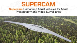
- 1. Supercam Unmanned Aerial Vehicles for Aerial Photography and Video Surveillance
- 2. About us info@unmanned.ru +7 (3412) 51-51-65 unmanned.ru UAV Systems Group designs and develops unmanned aerial vehicles (UAVs) for video surveillance and aerial photography, provides unmanned surveillance services for various big companies in the field of energy production, oil and gas industry, forest management, agricultural sector, state and industrial facilities security, construction industry, cadastral surveying, emergency containment, geodesy, mining geodesy, and etc. Our customers:
- 3. Own UAV production UAV Systems Group has own design engineering and production departments and full cycle of UAV development – from design to the complete system info@unmanned.ru +7 (3412) 51-51-65 unmanned.ru
- 4. Licenses and certificates The company has the following licenses and certificates: 1) License for aircrafts design, manufacture, testing and servicing issued by the Ministry of Industry and Commerce of the Russian Federation; 2) License for geodetic and mapping services on the federal level, the results of which have national and inter- branch significance, issued by the Federal Service of State Registration, Land Register and Mapping; 3) License to carry out educational activities on professional training of UAV operators, external pilots of unmanned aerial systems; 4) ISO 9001-2011 (ISO 9001:2008) quality management system certificate; 5) Declaration of conformity to the requirements of GOST 12.2.007.12-88, GOST R IEC 62133-2004, GOST R IEC1960- 2007 for lithium polymer accumulator batteries. info@unmanned.ru +7 (3412) 51-51-65 unmanned.ru
- 5. SUPERCAM UAV (fixed wing) Flight time up to 3 h Flight speed up to 120 km/h UAV wingspan 2.5 m Engine configuration – pulling Takeoff weight 7.5 - 9.5 kg Payload capacity 1.5 kg Operational height 100 - 5,000 m Maximal flight distance min 180 km Radio channel range of coverage up to 90 km Deployment time 15 min Launch – elastic catapult Recovery – parachute Supercam S250 Flight time up to 1.5 h Flight speed up to 120 km/h UAV wingspan 1 m Engine configuration – pulling Takeoff weight 2.5 kg Payload capacity up to 0.4 kg Operational height 150-500 m Maximal flight distance min 90 km Radio channel range of coverage up to 50 km Deployment time 15 min Launch – elastic catapult Recovery – parachute Supercam S100 info@unmanned.ru +7 (3412) 51-51-65 unmanned.ru
- 6. Flight time up to 5 h Flight speed up to 120 km/h UAV wingspan 3.2 m Engine configuration – pulling Takeoff weight 9.5 – 11.5 kg Payload capacity up to 2.5 kg Operational height 100 – 5,000 m Radio channel range of coverage up to 90 km Video transmitting channel range of coverage up to 50 km Deployment time 15 min Launch – elastic catapult Recovery – parachute Flight time up to 3.5 h Flight speed up to 120 km/h UAV wingspan 3 m Engine configuration – pushing Takeoff weight 9.5 - 11.5 kg Payload capacity up to 2.5 kg Operational height 50 - 5,500 m Operating ceiling 6,000 m Radio channel range of coverage up to 90 km Video transmitting channel range of coverage up to 50 km Deployment time 15 min Launch – elastic catapult Recovery – parachute Supercam S350Supercam S300 info@unmanned.ru +7 (3412) 51-51-65 unmanned.ru SUPERCAM UAV (fixed wing)
- 7. Flight time up to 30 min Dimensions 500х600х160 mm 6 rotors Takeoff weight 1.5 kg Payload capacity up to 0.3 kg Operational height 50 - 500 m Radio channel range of coverage up to 5 km Maximal flight distance 10 km Deployment time 10 min Flight speed up to 40 km/h Vertical take-off and landing Wind up to 10 m/s Temperature range -30°C +35°C Flight time up to 35 min Dimensions 1020х1070х420 mm 8 rotors Takeoff weight 8 kg Payload capacity up to 1.5 kg Operational height 50-500 m Radio channel range of coverage up to 5 km Deployment time 10 min Flight speed up to 60 km/h Vertical take-off and landing Wind up to 10 m/s Temperature range -30°C +35°C Flight time up to 50 min Dimensions 920х920х300 mm 6 rotors Takeoff weight up to 6 kg Payload capacity up to 1 kg Operational height 50-500 m Radio channel range of coverage up to 20 km Deployment time 15 min Flight speed up to 60 km/h Vertical take-off and landing Floatability min 120 min Supercam X6 Supercam X8-M Supercam X6-M2 SUPERCAM UAV (rotary wing) info@unmanned.ru +7 (3412) 51-51-65 unmanned.ru
- 8. Standard delivery Standard SUPERCAM UAV complex includes: Supercam UAV in the transportation case Ground control station in a shockproof, dustproof and waterproof case Elastic catapult Payload (camera, thermal imaging camera and etc.) The ground antenna on the tripod info@unmanned.ru unmanned.ru
- 9. Vehicle adaptation for a GCS Vehicle adaptation for a portable ground control station installation in compliance with the Customer requirements info@unmanned.ru +7 (3412) 51-51-65 unmanned.ru
- 10. SUPERCAM UAV flight preparation and launch UAV complex deployment time is 15 min. The UAV is launched with an elastic or pneumatic catapult info@unmanned.ru +7 (3412) 51-51-65 unmanned.ru
- 11. Emergency detection in the real-time mode Flight task is performed automatically according to the assigned flight path. During the flight online video is transmitted to the ground control station that enables UAV operator to detect emergencies in the real-time mode. info@unmanned.ru +7 (3412) 51-51-65 unmanned.ru
- 12. PAL 10x zoom Video camera Resolution 720х576 Optical zoom 10x Digital zoom 12x Video output NTSC, PAL Minimum illumination 1.0 lux (F1.8 NTSC: 1/60 sec, PAL: 1/50 sec) Platform type Gyro-stabilized platform 2 or 3 axes (3600 continuous rotation) Video is in the attached folder Payload types info@unmanned.ru +7 (3412) 51-51-65 unmanned.ru
- 13. PAL 28x zoom Video camera Resolution 720х576 Optical zoom 28x Digital zoom 12x Video output PAL Minimum illumination 0.4 lx (F1.35, AGC on, 1/50 s) 0.03 lx (F1.35, AGC on, 1/3 s) ICR-ON: 0.01 lx (F1.35, AGC on, 1/3 s) Platform type Gyro-stabilized platform 2 axes (3600 continuous rotation) Video is in the attached folder info@unmanned.ru +7 (3412) 51-51-65 unmanned.ru Payload types
- 14. HD 10x zoom Video camera Resolution 1080i (1920px x 1080) or 720p (1280 px × 720 px) Optical zoom 10x Digital zoom 12x Video output HD, NTSC, PAL Minimum illumination 12 lux (F1.8) with 50 IRE 1.0 lux ICR On (F1.8) with 50 IRE Platform type Gyro-stabilized platform 2 or 3 axes (3600 continuous rotation) Video is in the attached folder info@unmanned.ru +7 (3412) 51-51-65 unmanned.ru Payload types
- 15. 640х480 Thermal imaging camera Sensor Uncooled VOx Microbolometer Resolution 640х480 Pixel Pitch 17 μm Spectral Band 7.5 – 14 μm Frame rate 8.3 Hz - 50 Hz Lens options 7.5, 9, 13, 19, 25, 35, 50 mm Digital zoom 2х, 4х, 8х Platform type Fixed/ gyro-stabilized platform, integration with photo- video camera Video is in the attached folder A thermal imaging camera captures infrared radiation of the object and shows how warm it is in comparison to other objects in the scene. info@unmanned.ru +7 (3412) 51-51-65 unmanned.ru Payload types
- 16. Over High Sense camera Minimum illumination 0,00003 lux (F 0,8 s/n 20dB) Maximum illumination 150000 lux Platform type Gyro-stabilized platform 2 or 3 axes (3600 continuous rotation) Integration with photo- video camera and thermal imaging camera Video is in the attached folder Is intended for operation during fog and night-time. info@unmanned.ru +7 (3412) 51-51-65 unmanned.ru Payload types
- 17. 24 Mp Photo camera Total number of pixels 24.7 Effective number of pixels 24.3 Dimensions 23.4 x 15.6 mm Crop factor 1.5 Max resolution 6000 x 4000 Platform type Fixed platform, integration with other payloads info@unmanned.ru +7 (3412) 51-51-65 unmanned.ru Payload types
- 18. Automatic target tracking Automatic target tracking module enables target tracking in the real-time mode. It controls the camera position so the object is always in the center info@unmanned.ru +7 (3412) 51-51-65 unmanned.ru
- 19. Flight task performance and landing After flight task performance UAV automatically lands with a parachute. The data is processed after landing . info@unmanned.ru +7 (3412) 51-51-65 unmanned.ru
- 20. info@unmanned.ru +7 (3412) 51-51-65 unmanned.ru Data processing. Orthophotomaps Finco Piper Pro software allows to simultaneously upload several orthophotomaps of the same area taken at various dates. Analysis of layers of the same area taken at various time enables to promptly respond to the emergency detected (for layer view full-screen mode is required)* *only for Power Point presentations
- 21. Orthophotomaps. Scale 1:2000; 1:1000; 1:500 Fragment of orthophotomap, Scale 1:500 Orthophotomaps samples are in the attached folder info@unmanned.ru +7 (3412) 51-51-65 unmanned.ru
- 22. As a result of aerial photography digital 3D models are created. 3D models enable to accurately calculate the volume, size and distances with georeferencing Data processing. 3D modeling info@unmanned.ru +7 (3412) 51-51-65 unmanned.ru
- 23. High-resolution images enable to view locations in high quality and detect emergencies High-resolution images info@unmanned.ru +7 (3412) 51-51-65 unmanned.ru
- 24. info@unmanned.ru +7 (3412) 51-51-65 unmanned.ru *Aerial photography was made with Supercam S350 UAV High-resolution images enable to monitor work progress High-resolution images
- 25. Positional accuracy Signals of various satellites are used during the flight. Signals are recorded simultaneously at two receivers: base receiver rigidly mounted on the ground in the basic control point and on-board receiver mounted on the UAV. After flight is completed the data from the base and on-board receivers is processing that enables to obtain positional accuracy. info@unmanned.ru +7 (3412) 51-51-65 unmanned.ru
- 26. Made for ourselves We develop UAV complexes and provide services on the whole territory of the Russian Federation and abroad info@unmanned.ru +7 (3412) 51-51-65 unmanned.ru
- 27. For more information please visit our Web-site: unmanned.ru For demonstration flight arrangement please call +7 (3412) 51-51-65 E-mail: info@unmanned.ru