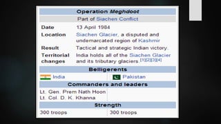
WAR ABOVE THE
CLOUDS:
SIACHEN GLACIER
AGENDA:
INTRODUCTION
HISTORY OF THE CONFLICT
STRATEGIC SIGNIFICANCE
PRESENT SITUATION
SOLUTION
CONCLUSION
INTRODUCTION
 Siachen: place of wild roses.
 Located in eastern Karakoram range in
Himalaya mountains.
 coordinates: 35.421226°N 77.109540°E
 Northeast to point NJ9842
 Length: 76km
 Area: 700 km2
 Largest in karakoram range
 2nd –longest in world’s non-polar areas
Lies between Saltoro ridge and
Karakorum range.
Main passes on this ridge (N S)
 Sia La
 Bilafond La
 Gyong La
 Average winter snowfall: 1000cm
 Temperature: can dip to −50 °C (−58 °F)
 Home to rare species:
 snow leopard
 brown bear
 ibex
CONFLICT
 Simla agreement 1972
 Both countries claim sovereignty over
barren hights
ZONE OF CONFLICT
 The battle zone comprised an inverted
triangle resting on NJ 9842 with Indira Col
and the Karakoram pass as the other two
extremities
HISTORY OF CONFLICT
 1949 Cease-Fire Line Agreement (CFL)
signed by both countries
 1957-1976 international expeditions
sought Pakistani authorization to visit
Siachen's nearby mountain peaks
 1967  Siachen Glacier clearly inside Pakistan
 Indian gov protested against cartography
 Prior to 1984 neither India nor Pakistan
had any permanent presence in the area
OPERATION MEGHDOOT
 Code-name for the Indian Armed Forces
operation to capture the Siachen Glacier
 precipitated the Siachen Conflict
 Launched on 13 April 1984
 Indian interpretation was that Pakistan
territory extended only to about the Saltoro
Ridge.
 Pakistan interpretation was that their territory
continued northeast from Point NJ9842 to the
Karakoram Pass.
 Both nations claimed the barren heights.
PAKISTAN MAJOR ASSAULTS
1987:
 headed by Brig Gen Pervaiz Mussharaf
 managed to capture a few high points
before being pushed back
1989:
 Unsuccessful
 Ground positions remained same
WHICH REGION SIACHEN
BELONGS
 All the international climbing and mountaineering
expedition teams to climb K2 and other
mountains,including Siachen always got their NoCs
from the Pakistani governments.
 Siachen has been shown as part of Pakistan in
many of international world atlases like UN
Defense Mapping Agency (DMA), Historical Atlas
of South Asia by Chicago University, Britannica
Atlas, National Geographic Society of World Atlas
and Times World Atlas.
STRATEGIC
SIGNIFICANCE OF
SIACHEN GLACIER
 The Siachen glacier is considered to be the
largest single source of fresh water as it is the
source of the Nubra River that eventually
feeds the mighty Indus.
 The Karakoram highway between China and
Pakistan is very close to Siachen which
enhances its strategic value.
 Current northern areas of
Pakistan and K-2.
 INDIA’S CLAIM:
 India’s stance is that the LoC runs from point NJ
9842 along the watersheds formed by the Saltoro
ridge that puts the entire Siachen glacier within
Indian territory.
 PAKISTAN’S CLAIM:
 Pakistan claims that the line joins point NJ 9842
with the Karakoram pass that lies towards the
northeast, putting Siachen within its territory.
PRESENT SITUATION
OF THE CONFLICT
 The Indian Army controls a few of the top-
most heights, holding on to the tactical
advantage of high ground, while the
Pakistani forces are controlling Baltoro and
other glaciers and valleys in immediate
West to Saltoro ridgeline.
 Presently India holds entire 75 KM of
Siachen glacier and commands two of the
three passes including the highest
motorable pass – Khardungla Pass
 Pakistan controls Gyong La pass that
overlooks the Shyok and Nubra river Valley
and India`s access to Leh district.
 Logistically, Pakistan Army holds the
advantage since its road-head is only 20 KM
away from the farthest post while Siachen is
a logistical nightmare for the Indian troops
who are stationed about 80 km away from
the road-head and their supplies have to be
maintained entirely by air.
SOLUTIONS
STEPS TOWARDS
RESOLVING THE ISSUE
INDIA’S POSITION ON
RESOLVING THE ISSUE
1. India wants Pakistan to 'verifies the map' and
remained insistent on accepting ' Actual Ground
Position Line' (AGPL) that began from NJ 9842 and
ended in the current Indian possessions on Soltaro
Range.
2. The Indian position is that both nations should
jointly demarcate the current troop positions in the
region.
PAKISTAN’S POSITION ON
RESOLVING THE ISSUE
1. Pakistan maintained its earlier proposal to
demilitarise the region.
2. . Pakistan agrees that the issue should be
resolved with talks but is strongly against a
demarcation of troop positions.
STEPS TOWARDS RESOLVING
THE ISSUE
 A year after India took over the glacier in 1984,
talks started. After 13 rounds, both sides are now
in agreement that the Siachen glacier should be
demilitarized as it is very tough to maintain army
over there.
 Efforts to de-militarize the Glacier in 1989 and in
1992 were set-aside after long rounds of Indo-Pak
negotiation. Politicians were– Rajiv Gandhi and
Benazir Bhutto
SUGGESTIONS
 A number of suggestions have been made on how
the problem can be resolved, including
1. Declaring the area a peace park,our last hope.
2. Joint patrolling of the region
3. International peacekeeping force being
deployed in the region.
CONCLUSION
 Sending men and material in such an area is
a very expensive affair.
 On an average India spends about Rs. 4
crore per day for maintaining troops in this
hostile area. Pakistan also spends about Rs.
1 crore for the same purpose.
 Even in normal circumstances, Indian
troops suffer one casualty every second
day while Pakistani troops suffer one
casualty every fourth day.
 Besides there are psychological disorders,
frostbite, high altitude pulmonary and
cerebral edema and snow blindness.
 The tragic incident of 7th April avalanche
that hit the HQ of 6NLI battalion of
Pakistan Army in Gyari sector of Siachen
trapping 139 Pakistani troops and civilians
that has traumatized the entire nation.
Meanwhile, up above the clouds, in the
icy glacier and peaks, the soldiers
continue to suffer and die, if not from
bullets then from nature, occasionally
looking down in the valley where
politicians of South Asia find it hard to
give peace a chance.
THANKYOU

SIACHEN CONFLICT

  • 1.
  • 3.
    AGENDA: INTRODUCTION HISTORY OF THECONFLICT STRATEGIC SIGNIFICANCE PRESENT SITUATION SOLUTION CONCLUSION
  • 5.
    INTRODUCTION  Siachen: placeof wild roses.  Located in eastern Karakoram range in Himalaya mountains.  coordinates: 35.421226°N 77.109540°E  Northeast to point NJ9842
  • 6.
     Length: 76km Area: 700 km2  Largest in karakoram range  2nd –longest in world’s non-polar areas
  • 7.
    Lies between Saltororidge and Karakorum range. Main passes on this ridge (N S)  Sia La  Bilafond La  Gyong La
  • 8.
     Average wintersnowfall: 1000cm  Temperature: can dip to −50 °C (−58 °F)  Home to rare species:  snow leopard  brown bear  ibex
  • 10.
    CONFLICT  Simla agreement1972  Both countries claim sovereignty over barren hights
  • 12.
    ZONE OF CONFLICT The battle zone comprised an inverted triangle resting on NJ 9842 with Indira Col and the Karakoram pass as the other two extremities
  • 14.
    HISTORY OF CONFLICT 1949 Cease-Fire Line Agreement (CFL) signed by both countries  1957-1976 international expeditions sought Pakistani authorization to visit Siachen's nearby mountain peaks  1967  Siachen Glacier clearly inside Pakistan
  • 16.
     Indian govprotested against cartography  Prior to 1984 neither India nor Pakistan had any permanent presence in the area
  • 17.
    OPERATION MEGHDOOT  Code-namefor the Indian Armed Forces operation to capture the Siachen Glacier  precipitated the Siachen Conflict  Launched on 13 April 1984
  • 18.
     Indian interpretationwas that Pakistan territory extended only to about the Saltoro Ridge.  Pakistan interpretation was that their territory continued northeast from Point NJ9842 to the Karakoram Pass.  Both nations claimed the barren heights.
  • 20.
    PAKISTAN MAJOR ASSAULTS 1987: headed by Brig Gen Pervaiz Mussharaf  managed to capture a few high points before being pushed back
  • 21.
    1989:  Unsuccessful  Groundpositions remained same
  • 22.
    WHICH REGION SIACHEN BELONGS All the international climbing and mountaineering expedition teams to climb K2 and other mountains,including Siachen always got their NoCs from the Pakistani governments.  Siachen has been shown as part of Pakistan in many of international world atlases like UN Defense Mapping Agency (DMA), Historical Atlas of South Asia by Chicago University, Britannica Atlas, National Geographic Society of World Atlas and Times World Atlas.
  • 23.
  • 25.
     The Siachenglacier is considered to be the largest single source of fresh water as it is the source of the Nubra River that eventually feeds the mighty Indus.  The Karakoram highway between China and Pakistan is very close to Siachen which enhances its strategic value.  Current northern areas of Pakistan and K-2.
  • 27.
     INDIA’S CLAIM: India’s stance is that the LoC runs from point NJ 9842 along the watersheds formed by the Saltoro ridge that puts the entire Siachen glacier within Indian territory.  PAKISTAN’S CLAIM:  Pakistan claims that the line joins point NJ 9842 with the Karakoram pass that lies towards the northeast, putting Siachen within its territory.
  • 28.
  • 29.
     The IndianArmy controls a few of the top- most heights, holding on to the tactical advantage of high ground, while the Pakistani forces are controlling Baltoro and other glaciers and valleys in immediate West to Saltoro ridgeline.  Presently India holds entire 75 KM of Siachen glacier and commands two of the three passes including the highest motorable pass – Khardungla Pass
  • 30.
     Pakistan controlsGyong La pass that overlooks the Shyok and Nubra river Valley and India`s access to Leh district.  Logistically, Pakistan Army holds the advantage since its road-head is only 20 KM away from the farthest post while Siachen is a logistical nightmare for the Indian troops who are stationed about 80 km away from the road-head and their supplies have to be maintained entirely by air.
  • 31.
  • 32.
    INDIA’S POSITION ON RESOLVINGTHE ISSUE 1. India wants Pakistan to 'verifies the map' and remained insistent on accepting ' Actual Ground Position Line' (AGPL) that began from NJ 9842 and ended in the current Indian possessions on Soltaro Range. 2. The Indian position is that both nations should jointly demarcate the current troop positions in the region.
  • 33.
    PAKISTAN’S POSITION ON RESOLVINGTHE ISSUE 1. Pakistan maintained its earlier proposal to demilitarise the region. 2. . Pakistan agrees that the issue should be resolved with talks but is strongly against a demarcation of troop positions.
  • 34.
    STEPS TOWARDS RESOLVING THEISSUE  A year after India took over the glacier in 1984, talks started. After 13 rounds, both sides are now in agreement that the Siachen glacier should be demilitarized as it is very tough to maintain army over there.  Efforts to de-militarize the Glacier in 1989 and in 1992 were set-aside after long rounds of Indo-Pak negotiation. Politicians were– Rajiv Gandhi and Benazir Bhutto
  • 35.
    SUGGESTIONS  A numberof suggestions have been made on how the problem can be resolved, including 1. Declaring the area a peace park,our last hope. 2. Joint patrolling of the region 3. International peacekeeping force being deployed in the region.
  • 36.
  • 37.
     Sending menand material in such an area is a very expensive affair.  On an average India spends about Rs. 4 crore per day for maintaining troops in this hostile area. Pakistan also spends about Rs. 1 crore for the same purpose.  Even in normal circumstances, Indian troops suffer one casualty every second day while Pakistani troops suffer one casualty every fourth day.
  • 38.
     Besides thereare psychological disorders, frostbite, high altitude pulmonary and cerebral edema and snow blindness.  The tragic incident of 7th April avalanche that hit the HQ of 6NLI battalion of Pakistan Army in Gyari sector of Siachen trapping 139 Pakistani troops and civilians that has traumatized the entire nation.
  • 40.
    Meanwhile, up abovethe clouds, in the icy glacier and peaks, the soldiers continue to suffer and die, if not from bullets then from nature, occasionally looking down in the valley where politicians of South Asia find it hard to give peace a chance.
  • 41.