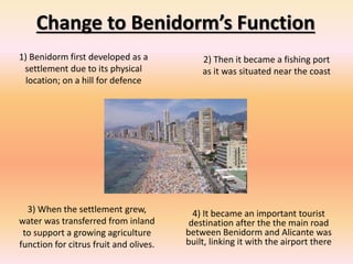
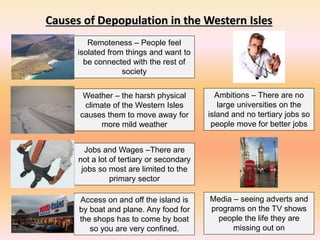
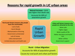
This document discusses functions of settlements and reasons for changes in settlements. It provides examples of how the functions of Benidorm, Spain changed over time from defense, to fishing, to agriculture, to a tourist destination. It also discusses causes of depopulation on Western Isles in Scotland, such as remoteness, jobs/wages, weather, ambitions, and media influences. Finally, it summarizes rapid urban growth in low-income countries, noting that natural increase and rural-urban migration account for population increases and pull factors like jobs attract people to cities.
Town planning and architecture
HISTORY OF GARDEN CITY
FEATURES OF GARDENCITY
EXAMPLES O GARDEN CITY
REFERENCE -TOWN PLANNING AND ARCHITECTURE ,R S AGRAWAL
This presentation is all about the Urban Structure of Paris where it is discussed about how the city is planned and developed from the scratch.
Do give your feedback and also an appreciation if liked this presentation.
Land use and land value theory ppt
William Alonso In location theory William Alonso (Location and Land Use: Toward a General Theory of Land Rent, 1964) built upon the Thünen model to account for intra-urban variations in land use. He attempted to apply accessibility requirements to the city centre for various types of land use (housing, commercial,…
land use and land value theory of william alonso ppt
william alonso
A commercial pdf that includes some nice detail on 3 case studies of quarry restoration that give a breadth of post quarrying uses. Very useful for Geography GCSE rocks and landscape
Urban Land use from the Human Elective for the Irish Leaving Cert. Contains some past exam questions. Deals with the Harp Project and urban issues in Dublin and Paris
We find urban renewal projects to be both fascinating and inspirational. They showcase amazing creativity and reviltalise neglected neighbourhoods, underused waterfronts or even entire cities. Here’s a list of 20, about half of which are just getting started.
To plan a city/region, we require base data on which information extrapolation & decisions may happen. Hence, Identify ‘data needed’, and Identify ‘needs of data’ collection
Inspection survey:
A) Direct :
Observe traffic count/ situation
Observe housing quality
Observe economic activity
Observe social parameters, etc.
B) Indirect:
Clubbing of directly observed ‘indicators’ to generate area’s possible ‘proxy’.
For e.g. housing condition + plot sizes + no. & types of vehicles + consumer goods = income range
. Personal interview/ Dialogue:
A questionnaire is designed beforehand at appropriate scale:
Nominal Scale : Yes or No
Ordinal Scale : Possible options or multiple choice questions
Interval Scale : Range/ intervals like age group or income group
Structured questions are precise and one-way
Semi-structure survey is a two-way information flow. It’s an informal dialogue in which the surveyor might receive new information from respondent/s. however, it depends on;
Behavioural factors of surveyor and respondents
Questions not to be ambiguous or long
Managing conversation and seeking pin-point answers
Judging responses without bias
Recording interview
Avoiding errors
Cross-checking with other respondents
Major land uses to be identified for analysing physical distribution and existing conditions:
Developed
Under-developed
Un-developed
Major uses marked on map are as per the defined regional/city level plans, like;
Urbanizable zone
Industrial zone
Transportation & Communication zone
roads, railways, MRTS, Seaports, Dockyards, Airports, Bus depots/ terminals, freight complexes, transmission and communication
Primary activity zone
Agriculture, poultry, rural settlements, brick kilns, extraction areas
Open area zone
Recreation zone, green buffer zone
Protected/ Eco-sensitive zone
Water bodies, forests, sanctuaries, coastal zone, wetlands, marshy zone
special area zone
Heritage & conservation zone, scenic value, tourism zone, defence area/ zone, border conflict zone
Data regarding demographic characteristics;
Population growth (natural, induced)
Population size (age-wise)
Population density
Population distribution
Gender ratio
Socio-Economic status
Religion
Marital status
Education ratio
School dropouts
Gender-wise enrolment in schools, colleges
Mortality rate (age-wise)
Birth rate
Health rate (in some surveys)
Sample types for doing household/ demographic surveys;
Simple Random sampling
Systematic sampling
Stratified sampling
Cluster sampling
Multistage sampling
There are nine steps involved in the development of a questionnaire:
Decide the information required.
Define the target respondents.
Choose the method(s) of reaching your target respondents.
Decide on question content.
Develop simple & clear wording of questions
Put the questions into a meaningful order and format.
Check the length of the questionnaire.
Pre-test the questionnaire
Develop the final survey form.
URBAN SPRAWL AND ITS CHANGING PARADIGMS A CASE STUDY OF JAIPUR CITYJournal For Research
There is widespread concern about understanding and curbing urban sprawl, which has been cited for its negative impacts on natural resources, economic development and quality of life of the society. There is not, however, a universally accepted definition of urban sprawl. It has been described using quantitative measures, qualitative terms, attitudinal explanations, and landscapes patterns. The increasing pace of urbanization is usually associated with and driven by the population concentration in an urban area over the periods. The extent of urbanization and its growth drives the change in land use land cover patterns results to urban areas continue to expand over the periods. So, this present study deals with the quantifying the spatial patterns in Jaipur city, analysis based on primary and secondary data collected from different sources, using the spatial analysis technique like Entropy Model for the detection of change in spatial and temporal variability of urban sprawl and the degree of spatial concentration or dispersion of geospatial variable. The boundary less cities are the new paradigms of development and Jaipur is no exception. The process of urban sprawl has been resulted due to the continuous industrial and economic development in the rural – urban fringe of the study area.
Local policies and strategies designed to deal with urban decline, decay or transformation are termed as urban renewal.
It is a comprehensive and integrated vision and action which leads to the resolution of urban problems and which seeks to bring about a lasting improvement in the economic, physical, social and environmental conditions of an area that has been subject to change’
With the decision and authority of a governing municipality, rearranging land use, function and ownership features of a socially, economically or structurally decayed part of a certain city .
such as slum zones or brown fields, for the purpose of obtaining a desired, well organized neighbourhood.
This slideshow covers AICE syllabus content on settlement dynamics. There are various interactive resources and assessments at the end of the presentation. Enjoy!
This powerpoint explains what counter urbanisation is within Human geography. It uses Headcorn as a case study and puts counter urbanisation into perspective. There are also key facts about Headcorn as a village and goes into details of the causes and effects of counter urbanisation.
Urban population in developing countries has grown 6.8 times between 1950 and 2000.
While it has merely doubled in the developed world in the corresponding period a rapid urbanization has put tremendous pressure on existing infrastructure and public services; pollution too is on and most strikingly, the population of the urban poor is increasing in many developing country cities.
How to Make a Field invisible in Odoo 17Celine George
It is possible to hide or invisible some fields in odoo. Commonly using “invisible” attribute in the field definition to invisible the fields. This slide will show how to make a field invisible in odoo 17.
June 3, 2024 Anti-Semitism Letter Sent to MIT President Kornbluth and MIT Cor...Levi Shapiro
Letter from the Congress of the United States regarding Anti-Semitism sent June 3rd to MIT President Sally Kornbluth, MIT Corp Chair, Mark Gorenberg
Dear Dr. Kornbluth and Mr. Gorenberg,
The US House of Representatives is deeply concerned by ongoing and pervasive acts of antisemitic
harassment and intimidation at the Massachusetts Institute of Technology (MIT). Failing to act decisively to ensure a safe learning environment for all students would be a grave dereliction of your responsibilities as President of MIT and Chair of the MIT Corporation.
This Congress will not stand idly by and allow an environment hostile to Jewish students to persist. The House believes that your institution is in violation of Title VI of the Civil Rights Act, and the inability or
unwillingness to rectify this violation through action requires accountability.
Postsecondary education is a unique opportunity for students to learn and have their ideas and beliefs challenged. However, universities receiving hundreds of millions of federal funds annually have denied
students that opportunity and have been hijacked to become venues for the promotion of terrorism, antisemitic harassment and intimidation, unlawful encampments, and in some cases, assaults and riots.
The House of Representatives will not countenance the use of federal funds to indoctrinate students into hateful, antisemitic, anti-American supporters of terrorism. Investigations into campus antisemitism by the Committee on Education and the Workforce and the Committee on Ways and Means have been expanded into a Congress-wide probe across all relevant jurisdictions to address this national crisis. The undersigned Committees will conduct oversight into the use of federal funds at MIT and its learning environment under authorities granted to each Committee.
• The Committee on Education and the Workforce has been investigating your institution since December 7, 2023. The Committee has broad jurisdiction over postsecondary education, including its compliance with Title VI of the Civil Rights Act, campus safety concerns over disruptions to the learning environment, and the awarding of federal student aid under the Higher Education Act.
• The Committee on Oversight and Accountability is investigating the sources of funding and other support flowing to groups espousing pro-Hamas propaganda and engaged in antisemitic harassment and intimidation of students. The Committee on Oversight and Accountability is the principal oversight committee of the US House of Representatives and has broad authority to investigate “any matter” at “any time” under House Rule X.
• The Committee on Ways and Means has been investigating several universities since November 15, 2023, when the Committee held a hearing entitled From Ivory Towers to Dark Corners: Investigating the Nexus Between Antisemitism, Tax-Exempt Universities, and Terror Financing. The Committee followed the hearing with letters to those institutions on January 10, 202
Biological screening of herbal drugs: Introduction and Need for
Phyto-Pharmacological Screening, New Strategies for evaluating
Natural Products, In vitro evaluation techniques for Antioxidants, Antimicrobial and Anticancer drugs. In vivo evaluation techniques
for Anti-inflammatory, Antiulcer, Anticancer, Wound healing, Antidiabetic, Hepatoprotective, Cardio protective, Diuretics and
Antifertility, Toxicity studies as per OECD guidelines
2024.06.01 Introducing a competency framework for languag learning materials ...Sandy Millin
http://sandymillin.wordpress.com/iateflwebinar2024
Published classroom materials form the basis of syllabuses, drive teacher professional development, and have a potentially huge influence on learners, teachers and education systems. All teachers also create their own materials, whether a few sentences on a blackboard, a highly-structured fully-realised online course, or anything in between. Despite this, the knowledge and skills needed to create effective language learning materials are rarely part of teacher training, and are mostly learnt by trial and error.
Knowledge and skills frameworks, generally called competency frameworks, for ELT teachers, trainers and managers have existed for a few years now. However, until I created one for my MA dissertation, there wasn’t one drawing together what we need to know and do to be able to effectively produce language learning materials.
This webinar will introduce you to my framework, highlighting the key competencies I identified from my research. It will also show how anybody involved in language teaching (any language, not just English!), teacher training, managing schools or developing language learning materials can benefit from using the framework.
The French Revolution, which began in 1789, was a period of radical social and political upheaval in France. It marked the decline of absolute monarchies, the rise of secular and democratic republics, and the eventual rise of Napoleon Bonaparte. This revolutionary period is crucial in understanding the transition from feudalism to modernity in Europe.
For more information, visit-www.vavaclasses.com
Francesca Gottschalk - How can education support child empowerment.pptxEduSkills OECD
Francesca Gottschalk from the OECD’s Centre for Educational Research and Innovation presents at the Ask an Expert Webinar: How can education support child empowerment?
A Strategic Approach: GenAI in EducationPeter Windle
Artificial Intelligence (AI) technologies such as Generative AI, Image Generators and Large Language Models have had a dramatic impact on teaching, learning and assessment over the past 18 months. The most immediate threat AI posed was to Academic Integrity with Higher Education Institutes (HEIs) focusing their efforts on combating the use of GenAI in assessment. Guidelines were developed for staff and students, policies put in place too. Innovative educators have forged paths in the use of Generative AI for teaching, learning and assessments leading to pockets of transformation springing up across HEIs, often with little or no top-down guidance, support or direction.
This Gasta posits a strategic approach to integrating AI into HEIs to prepare staff, students and the curriculum for an evolving world and workplace. We will highlight the advantages of working with these technologies beyond the realm of teaching, learning and assessment by considering prompt engineering skills, industry impact, curriculum changes, and the need for staff upskilling. In contrast, not engaging strategically with Generative AI poses risks, including falling behind peers, missed opportunities and failing to ensure our graduates remain employable. The rapid evolution of AI technologies necessitates a proactive and strategic approach if we are to remain relevant.
Acetabularia Information For Class 9 .docxvaibhavrinwa19
Acetabularia acetabulum is a single-celled green alga that in its vegetative state is morphologically differentiated into a basal rhizoid and an axially elongated stalk, which bears whorls of branching hairs. The single diploid nucleus resides in the rhizoid.
2. Functions of a Settlement
A function simply means what a settlement is used for.
Historically most settlements where for defence or to control
a piece of land, or for agriculture and trade.
However, most settlements now rely on the tertiary sector
and provide services such as shops, schools, hospitals and
entertainment
One function that is common to all settlements is to provide
housing. Some settlements have become dormitory
settlements where people commute to work but are only at
home in the evenings and weekends.
3. Change to Benidorm’s Function
1) Benidorm first developed as a
settlement due to its physical
location; on a hill for defence
2) Then it became a fishing port
as it was situated near the coast
3) When the settlement grew,
water was transferred from inland
to support a growing agriculture
function for citrus fruit and olives.
4) It became an important tourist
destination after the the main road
between Benidorm and Alicante was
built, linking it with the airport there
4. Causes of Depopulation in the Western Isles
Access on and off the island is
by boat and plane. Any food for
the shops has to come by boat
so you are very confined.
Remoteness – People feel
isolated from things and want to
be connected with the rest of
society
Jobs and Wages –There are
not a lot of tertiary or secondary
jobs so most are limited to the
primary sector
Weather – the harsh physical
climate of the Western Isles
causes them to move away for
more mild weather
Ambitions – There are no
large universities on the
island and no tertiary jobs so
people move for better jobs
Media – seeing adverts and
programs on the TV shows
people the life they are
missing out on
5. Counter-Urbanisation
Case Study – St Ives, Cambridge
Counter-urbanisation
– the movement of
people from the city
to the countryside
St Ives,
Cambridge
25% of people who
live there are
commuters
100km
north of
London
Close to the A1 motorway
and 50 min train journey
from King’s Cross
Half of the village are young
commuters the other half
are retired
Higher incomes and a
better standard of
living than anywhere
else in the UK
Modern housing
estates, designer
restaurants and
shops
6. Reasons for an increase in housing
demand in the UK
• Increase in population – between 2001
and 2011 the population increased
from 58.8 to 62.6 million people
• An increase in the number of
households – more people are living
alone, marrying later, divorce, and more
people are living longer. In 2001 there
were 21.6 million households. Of these
30% only had one person living in them.
• Increased personal wealth has resulted
in more people being able to afford to
buy their own home
7. Four possible locations for new
housing in the UK
Commuter Belt
New housing estates built
around existing towns
Eco-towns built on
brownfield land
Suburbs
Intensification by people
selling off their gardens for
building (garden grabbing)
and infilling any green
spaces with new housing
Inner City
Blocks of flats and gated
communities on Brownfield
sites
Urban Fringe
New housing estates built
(1) On the outer edge of a
built up area
(2) Around villages (use of
greenfield land
8. Commuter Belt
Compact estates on
Greenfield sites
Long journey to work
Car freeMost proposed sites are on
brownfield land
Not actually any jobs there so more
like commuter dormitories
Within the urban fringe and
commuter belt
Environmentally friendly – carbon
emissions kept low.
30% are for less well off
households
Compact estates on
Greenfield sites
20,000 new
homes in eco-
towns
9. Urban Fringe
Outer edge of the built
up area
Near to open
countryside but still
close to the city
Built on Greenfield sites
Loss of countryside High dependency on the
car to get around.
Lots of people of the same
economic class
Vast areas of low density
housing Still close to place of
work and best shops
Building of edge of town retail parks has
brought shops and leisure facilities closer
Recently offices and factories have
moved to the outer edge shortening
the journey times
10. Suburbs
Also involves ‘garden grabbing’ whereby people sell off some of
their garden as a building plot Gardens are brownfield not
greenfield and government
policy prefers brownfield
sites
Suburban intensification Occurs in the older suburbs
Involves building on playing
fields and vacant areas of
land
11. What factors encourage suburban sprawl?
Good transport links
Wasteful use of greenfield
sites
Greater wealth
Low density housing and lack
of planning
Growth in numbers of
households due to divorce
and people living longer
Shorter working hours
Unless there are very strict rules on house building it is very
easy for the suburbs to grow outwards and ‘sprawl’ over
large areas of countryside. Here are the reasons for this;
12. Inner City
Redevelopment of
brownfield sites
Housing located in the inner parts of towns
and cities that were once factories and slums
Concern about personal security is being
fixed with gated communities
Gated communities are
group of homes shut
away with CCTV and
electronic gates
Designed to offer
personal security and
protect property
Ideal for families
Redevelopment of
brownfield sites
Separates well off from less
well off people
Houses are expensive so can
only be an option for the
wealthy.
Targets for crime
People attracted back
to the centre by new
homes and better
facilities
13. Other factors in building new houses
There are laws about how new housing estates should be
build to make sure they are attractive to lots of different
people. Here are some of the considerations;
• Mix of housing types – houses, maisonettes, flats
• Size of house – 1, 2, 3, or 4 bedrooms
• A mix of owner occupied, rented and council housing
• Availability of work in the area
• Availability of utilities (water, gas, electricity)
• Access to services (shops, schools, pub)
• The environmental impact of new housing
14. Redevelopment of a deindustrialised area –
Bristol Harbourside
Deindustrialisation occurred because;
• Larger cargo ships that could not fit up the River Avon
• Competition from new docks at Avonmouth and Portbury.
• Closure of tobacco factories, a sand dredging industry and lead-shot works.
Problems
• Social and economic inequalities – a big divide between the very rich and very poor
• Large areas of derelict land
• High unemployment: in some areas it rose to almost 20%.
Solutions
• It was decided to redevelop the former dockland area.
• Lloyds TSB relocated their headquarters to the docklands area.
• Over the past thirty years, the area has undergone major changes finishing with the opening of the
new IMAX theatre, at-Bristol science museum and the Millennium Square.
Successes include:
• Over 3000 new jobs.
• A mixed environment that includes cafe bars, restaurants, cinemas, shops.
• New developments for the arts and sports facilities.
• An industrial museum and maritime heritage museum.
• The saving and usage of listed buildings. For example, the Watershed media centre that includes a
cinema, studios, art gallery and café bar was formerly two warehouses.
15. Advantages Disadvantages
Brownfield Site
• Reduces the loss of countryside
that might otherwise have been
taken for building
• Helps revive old disused urban
areas
• Services such as water, electricity,
sewers already in place
• Located new main areas of
employment so commuting time
reduced
• Often more expensive because old
buildings have to be cleared and the
land made free of pollution
• Often surrounded by rundown areas
so does not appeal to more wealthy
people
• Higher levels of pollution
• May not have good access in terms
of modern roads.
Greenfield Site
• Relatively cheap and rates of house
building are faster
• The layout is not restricted by other
buildings around it
• Healthier environment
• Valuable farm land lost
• Attractive scenery lost
• Wildlife and habitats lost of disturbed
• Development causes noise and light
pollution
• Encourages suburban sprawl
Greenfield vs Brownfield
16. Reasons for rapid growth in LIC urban areas
Rapid
Urban
Growth
Natural Increase – birth
rate higher than death rate
Accounts for 60% of
population growth
Urban pull factors (reasons why
people are attracted to the city)
- Better jobs
- Higher wages
- Better quality of life
- Better education and health
care
- Better utilities
Government support
Rural – Urban Migration
Accounts for 40% of population growth
Causes by rural push and urban pull factors
Rural push factors (reasons why people
leave the countryside)
- Lack of jobs
- Harsh lifestyle
- Mechanisation of farming
- Government uninterested
Lack of money
Little entertainment
Limited education and health care
17. Case Study of an LIC urban area - Dhaka, Bangladesh
• Dhaka is the capital city of Bangladesh
• One of the poorest countries in the world
• Cities population is an estimated 12 million but forecast to increase to 21 million by 2050
• Dhaka is hemmed in by large river channels that thread their way through the city
• It is these low-lying areas that suffer widespread flooding during the monsoon season
• It is in these places that the ‘bostis’ are built; Illegal shanty towns and squatter settlements that have been
built by rural to urban migrants that have come to the city looking for work.
• The authorities have not provided any other form of housing and they cannot afford to live elsewhere
• Overcrowding and disease are major problems
• Water pollution and rotting piles of waste are a real health hazard
• So too is the smoke from domestic fires and air pollution from the factories and traffic
• The most common diseases are diarrhoea, tuberculosis, measles, and malaria
• The growth of the population is outstripping the creation of jobs
• Most people work in the informal economy e.g. working for themselves
• Common jobs are; selling the street, shoe shining, rubbish collection, scavenging and recycling waste
• Begging crime and prostitution are also less legal ways of making a living.
• In Dhaka, the driving of rickshaws is the most common form of informal activity
• No public transport means the rickshaws are an important factor in keeping the city moving
• Half a million children are also estimated to be involved in the informal economy
• Most of them work from dawn til dusk and earn about 12p per day