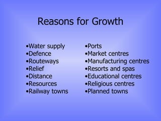
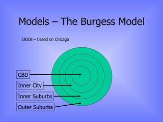
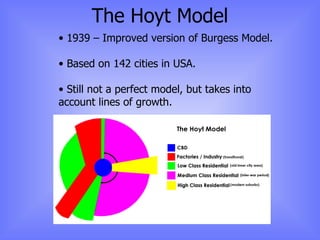
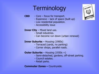
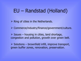
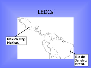
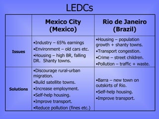
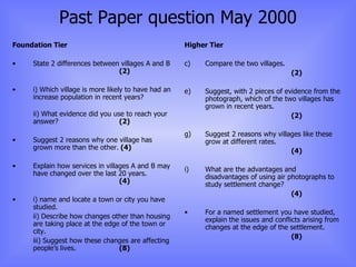
Geography Raise a Grade session: Settlement
Reasons for Growth Water supply Defence Routeways Relief Distance Resources Railway towns Ports Market centres Manufacturing centres Resorts and spas Educational centres Religious centres Planned towns
Models – The Burgess Model 1920s – based on Chicago CBD Inner City Inner Suburbs Outer Suburbs
The Hoyt Model 1939 – Improved version of Burgess Model. Based on 142 cities in USA. Still not a perfect model, but takes into account lines of growth.
Terminology CBD  - Core – focus for transport. - Expensive – lack of space (built up) - Low residential population. - Accessibility issue Inner City  – Mixed land use. - Small industries. - Can become run down (urban renewal) Inner Suburbs  – Housing (1900s) - Terraced (yards, no parking) - Corner shops, parallel roads. Outer Suburbs  – Housing (1930s +) - Semi-detached, gardens, off-street parking. - Council estates. - Retail parks. Commuter Zones –  Countryside.
Changes… CBD  -  Lack of accessibility. Inner City  – Redevelopment/regeneration.  Brownfield. Inner Suburbs  – Redevelopment. Outer Suburbs  – Retail parks. Commuter Zones  – In-migration. Reasons for changes… Transport influence (cars vs public transport): Location of industry (move from inner city to outer suburbs. Retail (move from CBD to outer suburbs)
UK Case Study: Birmingham
UK Case Study: Birmingham Generally regarded as the second city (London, Manchester and Birmingham have highest populations. 3 universities, 8 colleges, 457 schools. Central location – roads, railways and coaches. 80 minutes from London via train.
Traffic: Congestion, pollution, centre – pedestrianised. M6 – Northbound.  60km tailbacks common (relief road) Industry: Important in the industrial revolution.  Cadburys, Rover. Some traditional industries remain. Science and business parks growing. Business: International Convention Centre (1991).  NEC.  National Outdoor Arena. Population: Declining by 9% per decade. Growth of suburbs. Many immigrants from 50s – one of most significant ethnic minorities in UK. Conclusion: Changing image from dirty and industrial to progressive, innovative and forward-thinking.
UK - Bristol
UK - Winchcombe
UK - Winchcombe 1997 survey – half people moved into area in last 5 years. This increased house prices resulting in a lack of affordable housing. 53,000 more houses needed by 2011. Decisions are made on different levels:  National – Government. County Council – Gloucestershire. District Council – Tewkesbury. Local people.
UK - Cambridge
UK - Cambridge Boom area at the end of the 19 th  Century. Wages high – skills shortage. Move towards commuting = congestion. Public transport unable to cope. Many functions – university and tourism.
EU – Randstad (Holland)
EU – Randstad (Holland) Ring of cities in the Netherlands. Commerce/industry/finance/government/culture. Issues – housing in cities, land shortage, congestion and pollution, growth over green belt. Solutions – brownfield infill, improve transport, green buffer zones, renovation, preservation.
LEDCs Mexico City, Mexico. Rio de Janeiro, Brazil.
LEDCs Barra – new town on outskirts of Rio. Self-help housing. Improve transport. Discourage rural-urban migration. Build satellite towns. Increase employment. Self-help housing. Improve transport. Reduce pollution (fines etc.) Solutions Housing – population growth + shanty towns. Transport congestion. Crime – street children. Pollution – traffic + waste. Industry – 65% earnings Environment – old cars etc. Housing – high BR, falling DR.  Shanty towns. Issues Rio de Janeiro (Brazil) Mexico City (Mexico)
Past Paper question May 2000
Past Paper question May 2000 Foundation Tier State 2 differences between villages A and B (2) i) Which village is more likely to have had an increase population in recent years? ii) What evidence did you use to reach your answer? (2) Suggest 2 reasons why one village has grown more than the other.  (4) Explain how services in villages A and B may have changed over the last 20 years. (4) i) name and locate a town or city you have studied. ii) Describe how changes other than housing are taking place at the edge of the town or city. iii) Suggest how these changes are affecting people’s lives. (8) Higher Tier Compare the two villages. (2) Suggest, with 2 pieces of evidence from the photograph, which of the two villages has grown in recent years. (2) Suggest 2 reasons why villages like these grow at different rates. (4) What are the advantages and disadvantages of using air photographs to study settlement change? (4) For a named settlement you have studied, explain the issues and conflicts arising from changes at the edge of the settlement. (8)

Raise A Grade Session Settlement

  • 1.
    Geography Raise aGrade session: Settlement
  • 2.
    Reasons for GrowthWater supply Defence Routeways Relief Distance Resources Railway towns Ports Market centres Manufacturing centres Resorts and spas Educational centres Religious centres Planned towns
  • 3.
    Models – TheBurgess Model 1920s – based on Chicago CBD Inner City Inner Suburbs Outer Suburbs
  • 4.
    The Hoyt Model1939 – Improved version of Burgess Model. Based on 142 cities in USA. Still not a perfect model, but takes into account lines of growth.
  • 5.
    Terminology CBD - Core – focus for transport. - Expensive – lack of space (built up) - Low residential population. - Accessibility issue Inner City – Mixed land use. - Small industries. - Can become run down (urban renewal) Inner Suburbs – Housing (1900s) - Terraced (yards, no parking) - Corner shops, parallel roads. Outer Suburbs – Housing (1930s +) - Semi-detached, gardens, off-street parking. - Council estates. - Retail parks. Commuter Zones – Countryside.
  • 6.
    Changes… CBD - Lack of accessibility. Inner City – Redevelopment/regeneration. Brownfield. Inner Suburbs – Redevelopment. Outer Suburbs – Retail parks. Commuter Zones – In-migration. Reasons for changes… Transport influence (cars vs public transport): Location of industry (move from inner city to outer suburbs. Retail (move from CBD to outer suburbs)
  • 7.
    UK Case Study:Birmingham
  • 8.
    UK Case Study:Birmingham Generally regarded as the second city (London, Manchester and Birmingham have highest populations. 3 universities, 8 colleges, 457 schools. Central location – roads, railways and coaches. 80 minutes from London via train.
  • 9.
    Traffic: Congestion, pollution,centre – pedestrianised. M6 – Northbound. 60km tailbacks common (relief road) Industry: Important in the industrial revolution. Cadburys, Rover. Some traditional industries remain. Science and business parks growing. Business: International Convention Centre (1991). NEC. National Outdoor Arena. Population: Declining by 9% per decade. Growth of suburbs. Many immigrants from 50s – one of most significant ethnic minorities in UK. Conclusion: Changing image from dirty and industrial to progressive, innovative and forward-thinking.
  • 10.
  • 11.
  • 12.
    UK - Winchcombe1997 survey – half people moved into area in last 5 years. This increased house prices resulting in a lack of affordable housing. 53,000 more houses needed by 2011. Decisions are made on different levels: National – Government. County Council – Gloucestershire. District Council – Tewkesbury. Local people.
  • 13.
  • 14.
    UK - CambridgeBoom area at the end of the 19 th Century. Wages high – skills shortage. Move towards commuting = congestion. Public transport unable to cope. Many functions – university and tourism.
  • 15.
    EU – Randstad(Holland)
  • 16.
    EU – Randstad(Holland) Ring of cities in the Netherlands. Commerce/industry/finance/government/culture. Issues – housing in cities, land shortage, congestion and pollution, growth over green belt. Solutions – brownfield infill, improve transport, green buffer zones, renovation, preservation.
  • 17.
    LEDCs Mexico City,Mexico. Rio de Janeiro, Brazil.
  • 18.
    LEDCs Barra –new town on outskirts of Rio. Self-help housing. Improve transport. Discourage rural-urban migration. Build satellite towns. Increase employment. Self-help housing. Improve transport. Reduce pollution (fines etc.) Solutions Housing – population growth + shanty towns. Transport congestion. Crime – street children. Pollution – traffic + waste. Industry – 65% earnings Environment – old cars etc. Housing – high BR, falling DR. Shanty towns. Issues Rio de Janeiro (Brazil) Mexico City (Mexico)
  • 19.
  • 20.
    Past Paper questionMay 2000 Foundation Tier State 2 differences between villages A and B (2) i) Which village is more likely to have had an increase population in recent years? ii) What evidence did you use to reach your answer? (2) Suggest 2 reasons why one village has grown more than the other. (4) Explain how services in villages A and B may have changed over the last 20 years. (4) i) name and locate a town or city you have studied. ii) Describe how changes other than housing are taking place at the edge of the town or city. iii) Suggest how these changes are affecting people’s lives. (8) Higher Tier Compare the two villages. (2) Suggest, with 2 pieces of evidence from the photograph, which of the two villages has grown in recent years. (2) Suggest 2 reasons why villages like these grow at different rates. (4) What are the advantages and disadvantages of using air photographs to study settlement change? (4) For a named settlement you have studied, explain the issues and conflicts arising from changes at the edge of the settlement. (8)