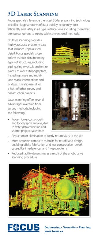
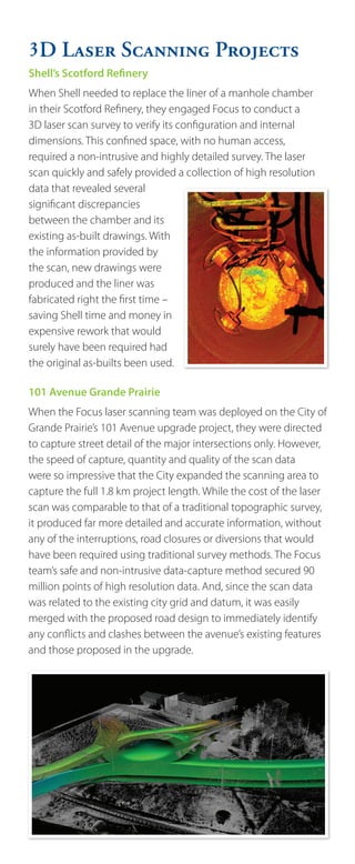
SlideShare a Scribd company logo
D Laser Scanning
Focus specialists leverage the latest 3D laser scanning technology
to collect large amounts of data quickly, accurately, cost-
efficiently and safely in all types of locations, including those that
are too dangerous to survey with conventional methods.

3D laser scanning provides
highly accurate proximity data
that includes unparalleled
detail. Focus specialists can
collect as-built data for many
types of structures, including
piping, single vessels and entire
plants, as well as topographies,
including single and multi-
lane roads, intersections and
bridges. It is also useful for
a host of other survey and
construction projects.

Laser scanning offers several
advantages over traditional
survey methods, including
the following:

• Proven lower cost as-built
  and topographic surveys, due
  to faster data collection and
  shorter project cycle times
• Reduction or elimination of costly ‘return visits’ to the site
• More accurate, complete as-builts for retrofit and design,
  enabling offsite fabrication and less construction rework
  caused by interferences and fit-up problems
• Reduced facility downtime, as a result of the unobtrusive
  scanning procedure
D Laser Scanning Projects
Shell’s Scotford Refinery
When Shell needed to replace the liner of a manhole chamber
in their Scotford Refinery, they engaged Focus to conduct a
3D laser scan survey to verify its configuration and internal
dimensions. This confined space, with no human access,
required a non-intrusive and highly detailed survey. The laser
scan quickly and safely provided a collection of high resolution
data that revealed several
significant discrepancies
between the chamber and its
existing as-built drawings. With
the information provided by
the scan, new drawings were
produced and the liner was
fabricated right the first time –
saving Shell time and money in
expensive rework that would
surely have been required had
the original as-builts been used.

101 Avenue Grande Prairie
When the Focus laser scanning team was deployed on the City of
Grande Prairie’s 101 Avenue upgrade project, they were directed
to capture street detail of the major intersections only. However,
the speed of capture, quantity and quality of the scan data
were so impressive that the City expanded the scanning area to
capture the full 1.8 km project length. While the cost of the laser
scan was comparable to that of a traditional topographic survey,
it produced far more detailed and accurate information, without
any of the interruptions, road closures or diversions that would
have been required using traditional survey methods. The Focus
team’s safe and non-intrusive data-capture method secured 90
million points of high resolution data. And, since the scan data
was related to the existing city grid and datum, it was easily
merged with the proposed road design to immediately identify
any conflicts and clashes between the avenue’s existing features
and those proposed in the upgrade.

More Related Content

What's hot

SmartGeo - G. Satta
SmartGeo - G. SattaSmartGeo - G. Satta
SmartGeo - G. Satta
Sardegna Ricerche
 
Watershed Delineation Using ArcMap
Watershed Delineation Using ArcMapWatershed Delineation Using ArcMap
Watershed Delineation Using ArcMap
Arthur Green
 
GIS for Infrastructure Management
GIS for Infrastructure ManagementGIS for Infrastructure Management
GIS for Infrastructure Management
David Puckett
 
DTM
DTMDTM
Heritage in Three-Dimensions
Heritage in Three-DimensionsHeritage in Three-Dimensions
Heritage in Three-Dimensions
Paul Cripps
 
Spar 2010 Presetation
Spar 2010 PresetationSpar 2010 Presetation
Spar 2010 Presetation
cformeller
 
Real-Time Analysis of Streaming Synchotron Data: SCinet SC19 Technology Chall...
Real-Time Analysis of Streaming Synchotron Data: SCinet SC19 Technology Chall...Real-Time Analysis of Streaming Synchotron Data: SCinet SC19 Technology Chall...
Real-Time Analysis of Streaming Synchotron Data: SCinet SC19 Technology Chall...
Globus
 
Masters_Prosentation_Final_Animate
Masters_Prosentation_Final_AnimateMasters_Prosentation_Final_Animate
Masters_Prosentation_Final_Animate
David Perry
 
High resolution dem dtm
High resolution dem dtmHigh resolution dem dtm
High resolution dem dtm
TTI Production
 
2013 Mission First Track, High-Definition Surveying - Mission First Reality b...
2013 Mission First Track, High-Definition Surveying - Mission First Reality b...2013 Mission First Track, High-Definition Surveying - Mission First Reality b...
2013 Mission First Track, High-Definition Surveying - Mission First Reality b...
GIS in the Rockies
 
Sundt - Laser Scanning
Sundt - Laser ScanningSundt - Laser Scanning
Sundt - Laser Scanning
Alan Sanoja
 
7 srtm paleochannels_aeromagnetics data
7 srtm paleochannels_aeromagnetics data7 srtm paleochannels_aeromagnetics data
7 srtm paleochannels_aeromagnetics data
IUMA MARTINEZ
 
TGS EUR- Barents Sea new 3D datasets
TGS EUR-  Barents Sea new 3D datasetsTGS EUR-  Barents Sea new 3D datasets
TGS EUR- Barents Sea new 3D datasets
TGS
 
Poor Mans GPS
Poor Mans GPSPoor Mans GPS
Poor Mans GPS
choonkeatss
 
Change detection
Change detection Change detection
Change detection
manoj1412001
 
A new cloud computing architecture for the classification of remote sensing data
A new cloud computing architecture for the classification of remote sensing dataA new cloud computing architecture for the classification of remote sensing data
A new cloud computing architecture for the classification of remote sensing data
Suhas Shriyan
 
Digital Elevation Models
Digital Elevation ModelsDigital Elevation Models
Digital Elevation Models
Bernd Flmla
 
Elevation hydrology tools kent pena
Elevation hydrology tools   kent penaElevation hydrology tools   kent pena
Elevation hydrology tools kent pena
Wisconsin Land Information Association
 
2017 PLSC Track: Grid vs Ground for the GIS Professional
2017 PLSC Track: Grid vs Ground for the GIS Professional2017 PLSC Track: Grid vs Ground for the GIS Professional
2017 PLSC Track: Grid vs Ground for the GIS Professional
GIS in the Rockies
 
SEPA - Esri UK Annual Conference 2016
SEPA - Esri UK Annual Conference 2016SEPA - Esri UK Annual Conference 2016
SEPA - Esri UK Annual Conference 2016
Esri UK
 

What's hot (20)

SmartGeo - G. Satta
SmartGeo - G. SattaSmartGeo - G. Satta
SmartGeo - G. Satta
 
Watershed Delineation Using ArcMap
Watershed Delineation Using ArcMapWatershed Delineation Using ArcMap
Watershed Delineation Using ArcMap
 
GIS for Infrastructure Management
GIS for Infrastructure ManagementGIS for Infrastructure Management
GIS for Infrastructure Management
 
DTM
DTMDTM
DTM
 
Heritage in Three-Dimensions
Heritage in Three-DimensionsHeritage in Three-Dimensions
Heritage in Three-Dimensions
 
Spar 2010 Presetation
Spar 2010 PresetationSpar 2010 Presetation
Spar 2010 Presetation
 
Real-Time Analysis of Streaming Synchotron Data: SCinet SC19 Technology Chall...
Real-Time Analysis of Streaming Synchotron Data: SCinet SC19 Technology Chall...Real-Time Analysis of Streaming Synchotron Data: SCinet SC19 Technology Chall...
Real-Time Analysis of Streaming Synchotron Data: SCinet SC19 Technology Chall...
 
Masters_Prosentation_Final_Animate
Masters_Prosentation_Final_AnimateMasters_Prosentation_Final_Animate
Masters_Prosentation_Final_Animate
 
High resolution dem dtm
High resolution dem dtmHigh resolution dem dtm
High resolution dem dtm
 
2013 Mission First Track, High-Definition Surveying - Mission First Reality b...
2013 Mission First Track, High-Definition Surveying - Mission First Reality b...2013 Mission First Track, High-Definition Surveying - Mission First Reality b...
2013 Mission First Track, High-Definition Surveying - Mission First Reality b...
 
Sundt - Laser Scanning
Sundt - Laser ScanningSundt - Laser Scanning
Sundt - Laser Scanning
 
7 srtm paleochannels_aeromagnetics data
7 srtm paleochannels_aeromagnetics data7 srtm paleochannels_aeromagnetics data
7 srtm paleochannels_aeromagnetics data
 
TGS EUR- Barents Sea new 3D datasets
TGS EUR-  Barents Sea new 3D datasetsTGS EUR-  Barents Sea new 3D datasets
TGS EUR- Barents Sea new 3D datasets
 
Poor Mans GPS
Poor Mans GPSPoor Mans GPS
Poor Mans GPS
 
Change detection
Change detection Change detection
Change detection
 
A new cloud computing architecture for the classification of remote sensing data
A new cloud computing architecture for the classification of remote sensing dataA new cloud computing architecture for the classification of remote sensing data
A new cloud computing architecture for the classification of remote sensing data
 
Digital Elevation Models
Digital Elevation ModelsDigital Elevation Models
Digital Elevation Models
 
Elevation hydrology tools kent pena
Elevation hydrology tools   kent penaElevation hydrology tools   kent pena
Elevation hydrology tools kent pena
 
2017 PLSC Track: Grid vs Ground for the GIS Professional
2017 PLSC Track: Grid vs Ground for the GIS Professional2017 PLSC Track: Grid vs Ground for the GIS Professional
2017 PLSC Track: Grid vs Ground for the GIS Professional
 
SEPA - Esri UK Annual Conference 2016
SEPA - Esri UK Annual Conference 2016SEPA - Esri UK Annual Conference 2016
SEPA - Esri UK Annual Conference 2016
 

Similar to Scanning Examples

Scanning with drones
Scanning with dronesScanning with drones
Scanning with drones
Aerial Visual Technologies LLC
 
presenter_mobilemapping_rail_HQ_print
presenter_mobilemapping_rail_HQ_printpresenter_mobilemapping_rail_HQ_print
presenter_mobilemapping_rail_HQ_print
Steve Jones
 
Laser Scanning: The Future Trend
Laser Scanning: The Future TrendLaser Scanning: The Future Trend
Laser Scanning: The Future Trend
Fishbeck, Thompson, Carr & Huber, Inc.
 
SEG14_Wednesday_lr 8
SEG14_Wednesday_lr 8SEG14_Wednesday_lr 8
SEG14_Wednesday_lr 8
Karla Keeton-Page
 
3D Laser Scanning for Oil & Gas Facilities
3D Laser Scanning for Oil & Gas Facilities3D Laser Scanning for Oil & Gas Facilities
3D Laser Scanning for Oil & Gas Facilities
Yasser Eldegwy
 
Presenter highways may23
Presenter highways may23Presenter highways may23
Presenter highways may23
Nick Blenkarn
 
Aerial surveying, cable location and other construction services by experts
Aerial surveying, cable location and other construction services by expertsAerial surveying, cable location and other construction services by experts
Aerial surveying, cable location and other construction services by experts
Aussie Hydro-Vac Services
 
Building Technology
Building TechnologyBuilding Technology
Building Technology
Ulises Uscanga
 
Bridge Scour
Bridge Scour Bridge Scour
Laser Scanning and 3-D Modeling of Jacobs Hall
Laser Scanning and 3-D Modeling of Jacobs HallLaser Scanning and 3-D Modeling of Jacobs Hall
Laser Scanning and 3-D Modeling of Jacobs Hall
Qudsia Wahab, EIT
 
ppt viva.pptx
ppt viva.pptxppt viva.pptx
ppt viva.pptx
ssuser6be36d
 
Terrestrial laser scanning
Terrestrial laser scanningTerrestrial laser scanning
Terrestrial laser scanning
Iris Kramer
 
Belfast City Centre 3D Modelling
Belfast City Centre 3D ModellingBelfast City Centre 3D Modelling
Belfast City Centre 3D Modelling
Ciara MacManus
 
Cudgen Road Tunnel Deformation Monitoring
Cudgen Road Tunnel Deformation MonitoringCudgen Road Tunnel Deformation Monitoring
Cudgen Road Tunnel Deformation Monitoring
Neil Kennedy
 
BIM Gets a Boost
BIM Gets a BoostBIM Gets a Boost
BIM Gets a Boost
Don Talend
 
MARINE SURVEYING
MARINE SURVEYINGMARINE SURVEYING
MARINE SURVEYING
Evgenia T. Akritidou
 
CTS a SANDIS Company
CTS a SANDIS CompanyCTS a SANDIS Company
CTS a SANDIS Company
Rob Ohata
 
CTS a SANDIS Company
CTS a SANDIS CompanyCTS a SANDIS Company
CTS a SANDIS Company
Davis Kantor
 
Revolutionize Your Projects with Falcon Survey's 3D Laser Scanning Survey Ser...
Revolutionize Your Projects with Falcon Survey's 3D Laser Scanning Survey Ser...Revolutionize Your Projects with Falcon Survey's 3D Laser Scanning Survey Ser...
Revolutionize Your Projects with Falcon Survey's 3D Laser Scanning Survey Ser...
falconsurveyme
 
Digital Concrete Rebar Scanning Revolutionizing Construction Industry
Digital Concrete Rebar Scanning Revolutionizing Construction IndustryDigital Concrete Rebar Scanning Revolutionizing Construction Industry
Digital Concrete Rebar Scanning Revolutionizing Construction Industry
Tec
 

Similar to Scanning Examples (20)

Scanning with drones
Scanning with dronesScanning with drones
Scanning with drones
 
presenter_mobilemapping_rail_HQ_print
presenter_mobilemapping_rail_HQ_printpresenter_mobilemapping_rail_HQ_print
presenter_mobilemapping_rail_HQ_print
 
Laser Scanning: The Future Trend
Laser Scanning: The Future TrendLaser Scanning: The Future Trend
Laser Scanning: The Future Trend
 
SEG14_Wednesday_lr 8
SEG14_Wednesday_lr 8SEG14_Wednesday_lr 8
SEG14_Wednesday_lr 8
 
3D Laser Scanning for Oil & Gas Facilities
3D Laser Scanning for Oil & Gas Facilities3D Laser Scanning for Oil & Gas Facilities
3D Laser Scanning for Oil & Gas Facilities
 
Presenter highways may23
Presenter highways may23Presenter highways may23
Presenter highways may23
 
Aerial surveying, cable location and other construction services by experts
Aerial surveying, cable location and other construction services by expertsAerial surveying, cable location and other construction services by experts
Aerial surveying, cable location and other construction services by experts
 
Building Technology
Building TechnologyBuilding Technology
Building Technology
 
Bridge Scour
Bridge Scour Bridge Scour
Bridge Scour
 
Laser Scanning and 3-D Modeling of Jacobs Hall
Laser Scanning and 3-D Modeling of Jacobs HallLaser Scanning and 3-D Modeling of Jacobs Hall
Laser Scanning and 3-D Modeling of Jacobs Hall
 
ppt viva.pptx
ppt viva.pptxppt viva.pptx
ppt viva.pptx
 
Terrestrial laser scanning
Terrestrial laser scanningTerrestrial laser scanning
Terrestrial laser scanning
 
Belfast City Centre 3D Modelling
Belfast City Centre 3D ModellingBelfast City Centre 3D Modelling
Belfast City Centre 3D Modelling
 
Cudgen Road Tunnel Deformation Monitoring
Cudgen Road Tunnel Deformation MonitoringCudgen Road Tunnel Deformation Monitoring
Cudgen Road Tunnel Deformation Monitoring
 
BIM Gets a Boost
BIM Gets a BoostBIM Gets a Boost
BIM Gets a Boost
 
MARINE SURVEYING
MARINE SURVEYINGMARINE SURVEYING
MARINE SURVEYING
 
CTS a SANDIS Company
CTS a SANDIS CompanyCTS a SANDIS Company
CTS a SANDIS Company
 
CTS a SANDIS Company
CTS a SANDIS CompanyCTS a SANDIS Company
CTS a SANDIS Company
 
Revolutionize Your Projects with Falcon Survey's 3D Laser Scanning Survey Ser...
Revolutionize Your Projects with Falcon Survey's 3D Laser Scanning Survey Ser...Revolutionize Your Projects with Falcon Survey's 3D Laser Scanning Survey Ser...
Revolutionize Your Projects with Falcon Survey's 3D Laser Scanning Survey Ser...
 
Digital Concrete Rebar Scanning Revolutionizing Construction Industry
Digital Concrete Rebar Scanning Revolutionizing Construction IndustryDigital Concrete Rebar Scanning Revolutionizing Construction Industry
Digital Concrete Rebar Scanning Revolutionizing Construction Industry
 

Recently uploaded

Mutation Testing for Task-Oriented Chatbots
Mutation Testing for Task-Oriented ChatbotsMutation Testing for Task-Oriented Chatbots
Mutation Testing for Task-Oriented Chatbots
Pablo Gómez Abajo
 
LF Energy Webinar: Carbon Data Specifications: Mechanisms to Improve Data Acc...
LF Energy Webinar: Carbon Data Specifications: Mechanisms to Improve Data Acc...LF Energy Webinar: Carbon Data Specifications: Mechanisms to Improve Data Acc...
LF Energy Webinar: Carbon Data Specifications: Mechanisms to Improve Data Acc...
DanBrown980551
 
Essentials of Automations: Exploring Attributes & Automation Parameters
Essentials of Automations: Exploring Attributes & Automation ParametersEssentials of Automations: Exploring Attributes & Automation Parameters
Essentials of Automations: Exploring Attributes & Automation Parameters
Safe Software
 
Must Know Postgres Extension for DBA and Developer during Migration
Must Know Postgres Extension for DBA and Developer during MigrationMust Know Postgres Extension for DBA and Developer during Migration
Must Know Postgres Extension for DBA and Developer during Migration
Mydbops
 
[OReilly Superstream] Occupy the Space: A grassroots guide to engineering (an...
[OReilly Superstream] Occupy the Space: A grassroots guide to engineering (an...[OReilly Superstream] Occupy the Space: A grassroots guide to engineering (an...
[OReilly Superstream] Occupy the Space: A grassroots guide to engineering (an...
Jason Yip
 
The Microsoft 365 Migration Tutorial For Beginner.pptx
The Microsoft 365 Migration Tutorial For Beginner.pptxThe Microsoft 365 Migration Tutorial For Beginner.pptx
The Microsoft 365 Migration Tutorial For Beginner.pptx
operationspcvita
 
Freshworks Rethinks NoSQL for Rapid Scaling & Cost-Efficiency
Freshworks Rethinks NoSQL for Rapid Scaling & Cost-EfficiencyFreshworks Rethinks NoSQL for Rapid Scaling & Cost-Efficiency
Freshworks Rethinks NoSQL for Rapid Scaling & Cost-Efficiency
ScyllaDB
 
Main news related to the CCS TSI 2023 (2023/1695)
Main news related to the CCS TSI 2023 (2023/1695)Main news related to the CCS TSI 2023 (2023/1695)
Main news related to the CCS TSI 2023 (2023/1695)
Jakub Marek
 
Demystifying Knowledge Management through Storytelling
Demystifying Knowledge Management through StorytellingDemystifying Knowledge Management through Storytelling
Demystifying Knowledge Management through Storytelling
Enterprise Knowledge
 
Choosing The Best AWS Service For Your Website + API.pptx
Choosing The Best AWS Service For Your Website + API.pptxChoosing The Best AWS Service For Your Website + API.pptx
Choosing The Best AWS Service For Your Website + API.pptx
Brandon Minnick, MBA
 
Fueling AI with Great Data with Airbyte Webinar
Fueling AI with Great Data with Airbyte WebinarFueling AI with Great Data with Airbyte Webinar
Fueling AI with Great Data with Airbyte Webinar
Zilliz
 
Connector Corner: Seamlessly power UiPath Apps, GenAI with prebuilt connectors
Connector Corner: Seamlessly power UiPath Apps, GenAI with prebuilt connectorsConnector Corner: Seamlessly power UiPath Apps, GenAI with prebuilt connectors
Connector Corner: Seamlessly power UiPath Apps, GenAI with prebuilt connectors
DianaGray10
 
Biomedical Knowledge Graphs for Data Scientists and Bioinformaticians
Biomedical Knowledge Graphs for Data Scientists and BioinformaticiansBiomedical Knowledge Graphs for Data Scientists and Bioinformaticians
Biomedical Knowledge Graphs for Data Scientists and Bioinformaticians
Neo4j
 
"$10 thousand per minute of downtime: architecture, queues, streaming and fin...
"$10 thousand per minute of downtime: architecture, queues, streaming and fin..."$10 thousand per minute of downtime: architecture, queues, streaming and fin...
"$10 thousand per minute of downtime: architecture, queues, streaming and fin...
Fwdays
 
“Temporal Event Neural Networks: A More Efficient Alternative to the Transfor...
“Temporal Event Neural Networks: A More Efficient Alternative to the Transfor...“Temporal Event Neural Networks: A More Efficient Alternative to the Transfor...
“Temporal Event Neural Networks: A More Efficient Alternative to the Transfor...
Edge AI and Vision Alliance
 
"Choosing proper type of scaling", Olena Syrota
"Choosing proper type of scaling", Olena Syrota"Choosing proper type of scaling", Olena Syrota
"Choosing proper type of scaling", Olena Syrota
Fwdays
 
"Frontline Battles with DDoS: Best practices and Lessons Learned", Igor Ivaniuk
"Frontline Battles with DDoS: Best practices and Lessons Learned",  Igor Ivaniuk"Frontline Battles with DDoS: Best practices and Lessons Learned",  Igor Ivaniuk
"Frontline Battles with DDoS: Best practices and Lessons Learned", Igor Ivaniuk
Fwdays
 
Session 1 - Intro to Robotic Process Automation.pdf
Session 1 - Intro to Robotic Process Automation.pdfSession 1 - Intro to Robotic Process Automation.pdf
Session 1 - Intro to Robotic Process Automation.pdf
UiPathCommunity
 
Northern Engraving | Modern Metal Trim, Nameplates and Appliance Panels
Northern Engraving | Modern Metal Trim, Nameplates and Appliance PanelsNorthern Engraving | Modern Metal Trim, Nameplates and Appliance Panels
Northern Engraving | Modern Metal Trim, Nameplates and Appliance Panels
Northern Engraving
 
Skybuffer SAM4U tool for SAP license adoption
Skybuffer SAM4U tool for SAP license adoptionSkybuffer SAM4U tool for SAP license adoption
Skybuffer SAM4U tool for SAP license adoption
Tatiana Kojar
 

Recently uploaded (20)

Mutation Testing for Task-Oriented Chatbots
Mutation Testing for Task-Oriented ChatbotsMutation Testing for Task-Oriented Chatbots
Mutation Testing for Task-Oriented Chatbots
 
LF Energy Webinar: Carbon Data Specifications: Mechanisms to Improve Data Acc...
LF Energy Webinar: Carbon Data Specifications: Mechanisms to Improve Data Acc...LF Energy Webinar: Carbon Data Specifications: Mechanisms to Improve Data Acc...
LF Energy Webinar: Carbon Data Specifications: Mechanisms to Improve Data Acc...
 
Essentials of Automations: Exploring Attributes & Automation Parameters
Essentials of Automations: Exploring Attributes & Automation ParametersEssentials of Automations: Exploring Attributes & Automation Parameters
Essentials of Automations: Exploring Attributes & Automation Parameters
 
Must Know Postgres Extension for DBA and Developer during Migration
Must Know Postgres Extension for DBA and Developer during MigrationMust Know Postgres Extension for DBA and Developer during Migration
Must Know Postgres Extension for DBA and Developer during Migration
 
[OReilly Superstream] Occupy the Space: A grassroots guide to engineering (an...
[OReilly Superstream] Occupy the Space: A grassroots guide to engineering (an...[OReilly Superstream] Occupy the Space: A grassroots guide to engineering (an...
[OReilly Superstream] Occupy the Space: A grassroots guide to engineering (an...
 
The Microsoft 365 Migration Tutorial For Beginner.pptx
The Microsoft 365 Migration Tutorial For Beginner.pptxThe Microsoft 365 Migration Tutorial For Beginner.pptx
The Microsoft 365 Migration Tutorial For Beginner.pptx
 
Freshworks Rethinks NoSQL for Rapid Scaling & Cost-Efficiency
Freshworks Rethinks NoSQL for Rapid Scaling & Cost-EfficiencyFreshworks Rethinks NoSQL for Rapid Scaling & Cost-Efficiency
Freshworks Rethinks NoSQL for Rapid Scaling & Cost-Efficiency
 
Main news related to the CCS TSI 2023 (2023/1695)
Main news related to the CCS TSI 2023 (2023/1695)Main news related to the CCS TSI 2023 (2023/1695)
Main news related to the CCS TSI 2023 (2023/1695)
 
Demystifying Knowledge Management through Storytelling
Demystifying Knowledge Management through StorytellingDemystifying Knowledge Management through Storytelling
Demystifying Knowledge Management through Storytelling
 
Choosing The Best AWS Service For Your Website + API.pptx
Choosing The Best AWS Service For Your Website + API.pptxChoosing The Best AWS Service For Your Website + API.pptx
Choosing The Best AWS Service For Your Website + API.pptx
 
Fueling AI with Great Data with Airbyte Webinar
Fueling AI with Great Data with Airbyte WebinarFueling AI with Great Data with Airbyte Webinar
Fueling AI with Great Data with Airbyte Webinar
 
Connector Corner: Seamlessly power UiPath Apps, GenAI with prebuilt connectors
Connector Corner: Seamlessly power UiPath Apps, GenAI with prebuilt connectorsConnector Corner: Seamlessly power UiPath Apps, GenAI with prebuilt connectors
Connector Corner: Seamlessly power UiPath Apps, GenAI with prebuilt connectors
 
Biomedical Knowledge Graphs for Data Scientists and Bioinformaticians
Biomedical Knowledge Graphs for Data Scientists and BioinformaticiansBiomedical Knowledge Graphs for Data Scientists and Bioinformaticians
Biomedical Knowledge Graphs for Data Scientists and Bioinformaticians
 
"$10 thousand per minute of downtime: architecture, queues, streaming and fin...
"$10 thousand per minute of downtime: architecture, queues, streaming and fin..."$10 thousand per minute of downtime: architecture, queues, streaming and fin...
"$10 thousand per minute of downtime: architecture, queues, streaming and fin...
 
“Temporal Event Neural Networks: A More Efficient Alternative to the Transfor...
“Temporal Event Neural Networks: A More Efficient Alternative to the Transfor...“Temporal Event Neural Networks: A More Efficient Alternative to the Transfor...
“Temporal Event Neural Networks: A More Efficient Alternative to the Transfor...
 
"Choosing proper type of scaling", Olena Syrota
"Choosing proper type of scaling", Olena Syrota"Choosing proper type of scaling", Olena Syrota
"Choosing proper type of scaling", Olena Syrota
 
"Frontline Battles with DDoS: Best practices and Lessons Learned", Igor Ivaniuk
"Frontline Battles with DDoS: Best practices and Lessons Learned",  Igor Ivaniuk"Frontline Battles with DDoS: Best practices and Lessons Learned",  Igor Ivaniuk
"Frontline Battles with DDoS: Best practices and Lessons Learned", Igor Ivaniuk
 
Session 1 - Intro to Robotic Process Automation.pdf
Session 1 - Intro to Robotic Process Automation.pdfSession 1 - Intro to Robotic Process Automation.pdf
Session 1 - Intro to Robotic Process Automation.pdf
 
Northern Engraving | Modern Metal Trim, Nameplates and Appliance Panels
Northern Engraving | Modern Metal Trim, Nameplates and Appliance PanelsNorthern Engraving | Modern Metal Trim, Nameplates and Appliance Panels
Northern Engraving | Modern Metal Trim, Nameplates and Appliance Panels
 
Skybuffer SAM4U tool for SAP license adoption
Skybuffer SAM4U tool for SAP license adoptionSkybuffer SAM4U tool for SAP license adoption
Skybuffer SAM4U tool for SAP license adoption
 

Scanning Examples

  • 1. D Laser Scanning Focus specialists leverage the latest 3D laser scanning technology to collect large amounts of data quickly, accurately, cost- efficiently and safely in all types of locations, including those that are too dangerous to survey with conventional methods. 3D laser scanning provides highly accurate proximity data that includes unparalleled detail. Focus specialists can collect as-built data for many types of structures, including piping, single vessels and entire plants, as well as topographies, including single and multi- lane roads, intersections and bridges. It is also useful for a host of other survey and construction projects. Laser scanning offers several advantages over traditional survey methods, including the following: • Proven lower cost as-built and topographic surveys, due to faster data collection and shorter project cycle times • Reduction or elimination of costly ‘return visits’ to the site • More accurate, complete as-builts for retrofit and design, enabling offsite fabrication and less construction rework caused by interferences and fit-up problems • Reduced facility downtime, as a result of the unobtrusive scanning procedure
  • 2. D Laser Scanning Projects Shell’s Scotford Refinery When Shell needed to replace the liner of a manhole chamber in their Scotford Refinery, they engaged Focus to conduct a 3D laser scan survey to verify its configuration and internal dimensions. This confined space, with no human access, required a non-intrusive and highly detailed survey. The laser scan quickly and safely provided a collection of high resolution data that revealed several significant discrepancies between the chamber and its existing as-built drawings. With the information provided by the scan, new drawings were produced and the liner was fabricated right the first time – saving Shell time and money in expensive rework that would surely have been required had the original as-builts been used. 101 Avenue Grande Prairie When the Focus laser scanning team was deployed on the City of Grande Prairie’s 101 Avenue upgrade project, they were directed to capture street detail of the major intersections only. However, the speed of capture, quantity and quality of the scan data were so impressive that the City expanded the scanning area to capture the full 1.8 km project length. While the cost of the laser scan was comparable to that of a traditional topographic survey, it produced far more detailed and accurate information, without any of the interruptions, road closures or diversions that would have been required using traditional survey methods. The Focus team’s safe and non-intrusive data-capture method secured 90 million points of high resolution data. And, since the scan data was related to the existing city grid and datum, it was easily merged with the proposed road design to immediately identify any conflicts and clashes between the avenue’s existing features and those proposed in the upgrade.