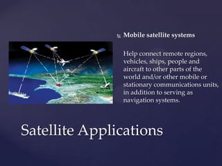
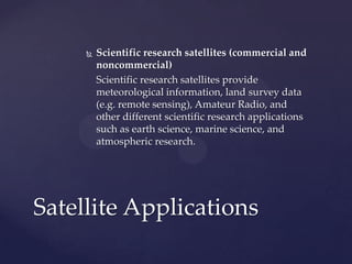
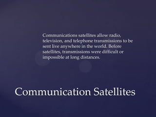
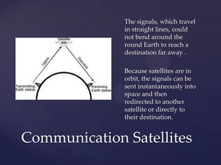
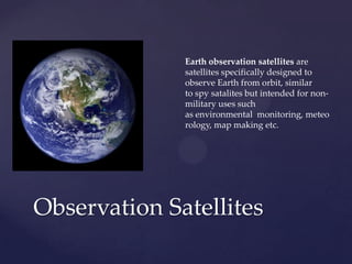
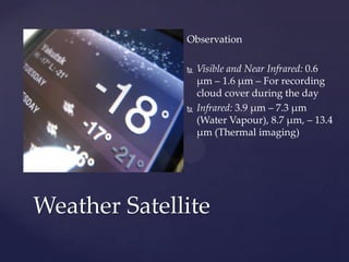
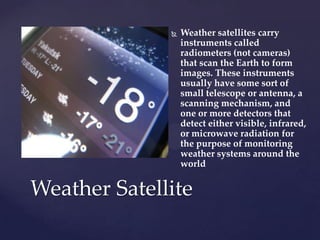
Satellite applications can be categorized into four main types: communication satellites, navigation satellites, observation satellites, and weather satellites. Communication satellites allow for radio, television, and telephone transmissions globally. Navigation satellites like GPS use timing signals from satellites to precisely determine location. Observation satellites are used for non-military purposes like environmental monitoring and map making. Weather satellites scan Earth with instruments to form images of cloud cover, temperatures, and weather systems.
This presentation covers:
Basics of Satellite communication
Indian Communication satellites
Satellite link and elements of satellite communication
Frequency bands of satellite communication
Different orbits of satellite communication
Link budget calculations
This presentation covers:
Basics of Satellite communication
Indian Communication satellites
Satellite link and elements of satellite communication
Frequency bands of satellite communication
Different orbits of satellite communication
Link budget calculations
Presentation on Satellite Communication
Outlines:
History
Definition
Communication system
Architecture
Operation of satellite
Elements
>Space Segment
>Ground Segment
Earth Stations
Digital Earth Station
Orbits
Geostationary Orbit (GSO)
Non-Geostationary Orbit (NGSO)
Different Satellite Communications : Services
Advantages OF SATELLITE COMMUNICATION
Applications OF SATELLITE COMMUNICATION
Future
Conclusion
hiee guyes this is swapnil thaware here i uploaded slide for your knowledge if you want more detail msg me on fb or mail i will help you
thanking you and slideshare.com
this presentation is about satellite communication which includes working of gps ,vsat ,frequency bands ,needs of communication satellite ,types of satellite ,working ,orbits ,elements involved in working ,transponder ,satellite control center ,satellite network
Group presentation done on GPS technology it covers
1.Introduction -History,Background
2.What is GPS - Technology, infrastructure
3.How GPS Works - Theory,Mathematical explanation
4.Applications of GPS
5.Drawbacks of GPS
6.Future Development
#References are added to the note section of the slides.
Geostationary Earth Orbit (GEO) Satellite Systems • A geostationary orbit is a special type of geosynchronous orbit. • When an object is in geostationary orbit, it is orbiting at the same speed as the Earth rotates, but it orbits around the equator.
The theory of satellites was simple enough - shoot something out into space at the right speed and on the correct trajectory and it will stay up there, orbiting Earth, for years - if not forever. If the orbit is the right distance in space the satellite will keep pace with the rotation of the Earth.
Early in October 1957 communications stations started picking up a regular beeping noise coming from space.
The signals were coming from Russia's Sputnik 1, the world's first man-made satellite.
It was January 1958, before a Jupiter rocket successfully launched Explorer 1, the first American satellite
This is a introductory notes about Satellite system. It contain details about the history, different type of characteristics & various applications of satellite system. It also include details about four types of orbits- LEO, MEO, HEO, GEO.
PPT Obstructs: Outline about Meteorological satellites and their types. principle of Satellite remote sensing - Electro Magnetic Spectrum, Data from weather satellites.
Information for Satellite, What is a Satellite...YaserKhan21
What is a Satellite?, Types of Satellite, Satellite Architecture and Organization, Application
Advantages of satellite over terrestrial communication, Disadvantage, Brief History of Artificial Satellites, Parts of a Satellite, What Keeps A Satellite from Falling to Earth?, What stops a Satellite from crashing into another Satellite?, Moons Around Other Worlds, About the International Space Station, Satellites in ISRO, Chandrayaan-1, Chandrayaan-2 and Chandrayaan-3
A satellite system is a set of gravitationally bound objects in orbit around a planetary-mass object or minor planet, or its barycenter. Generally speaking, it is a set of natural satellites (moons), although such systems may also consist of bodies such as circumplanetary disks, ring systems, moonlets, minor-planet moons, and artificial satellites any which may themselves have satellite systems of their own.
Essentials of Automations: Optimizing FME Workflows with ParametersSafe Software
Are you looking to streamline your workflows and boost your projects’ efficiency? Do you find yourself searching for ways to add flexibility and control over your FME workflows? If so, you’re in the right place.
Join us for an insightful dive into the world of FME parameters, a critical element in optimizing workflow efficiency. This webinar marks the beginning of our three-part “Essentials of Automation” series. This first webinar is designed to equip you with the knowledge and skills to utilize parameters effectively: enhancing the flexibility, maintainability, and user control of your FME projects.
Here’s what you’ll gain:
- Essentials of FME Parameters: Understand the pivotal role of parameters, including Reader/Writer, Transformer, User, and FME Flow categories. Discover how they are the key to unlocking automation and optimization within your workflows.
- Practical Applications in FME Form: Delve into key user parameter types including choice, connections, and file URLs. Allow users to control how a workflow runs, making your workflows more reusable. Learn to import values and deliver the best user experience for your workflows while enhancing accuracy.
- Optimization Strategies in FME Flow: Explore the creation and strategic deployment of parameters in FME Flow, including the use of deployment and geometry parameters, to maximize workflow efficiency.
- Pro Tips for Success: Gain insights on parameterizing connections and leveraging new features like Conditional Visibility for clarity and simplicity.
We’ll wrap up with a glimpse into future webinars, followed by a Q&A session to address your specific questions surrounding this topic.
Don’t miss this opportunity to elevate your FME expertise and drive your projects to new heights of efficiency.
GDG Cloud Southlake #33: Boule & Rebala: Effective AppSec in SDLC using Deplo...James Anderson
Effective Application Security in Software Delivery lifecycle using Deployment Firewall and DBOM
The modern software delivery process (or the CI/CD process) includes many tools, distributed teams, open-source code, and cloud platforms. Constant focus on speed to release software to market, along with the traditional slow and manual security checks has caused gaps in continuous security as an important piece in the software supply chain. Today organizations feel more susceptible to external and internal cyber threats due to the vast attack surface in their applications supply chain and the lack of end-to-end governance and risk management.
The software team must secure its software delivery process to avoid vulnerability and security breaches. This needs to be achieved with existing tool chains and without extensive rework of the delivery processes. This talk will present strategies and techniques for providing visibility into the true risk of the existing vulnerabilities, preventing the introduction of security issues in the software, resolving vulnerabilities in production environments quickly, and capturing the deployment bill of materials (DBOM).
Speakers:
Bob Boule
Robert Boule is a technology enthusiast with PASSION for technology and making things work along with a knack for helping others understand how things work. He comes with around 20 years of solution engineering experience in application security, software continuous delivery, and SaaS platforms. He is known for his dynamic presentations in CI/CD and application security integrated in software delivery lifecycle.
Gopinath Rebala
Gopinath Rebala is the CTO of OpsMx, where he has overall responsibility for the machine learning and data processing architectures for Secure Software Delivery. Gopi also has a strong connection with our customers, leading design and architecture for strategic implementations. Gopi is a frequent speaker and well-known leader in continuous delivery and integrating security into software delivery.
Search and Society: Reimagining Information Access for Radical FuturesBhaskar Mitra
The field of Information retrieval (IR) is currently undergoing a transformative shift, at least partly due to the emerging applications of generative AI to information access. In this talk, we will deliberate on the sociotechnical implications of generative AI for information access. We will argue that there is both a critical necessity and an exciting opportunity for the IR community to re-center our research agendas on societal needs while dismantling the artificial separation between the work on fairness, accountability, transparency, and ethics in IR and the rest of IR research. Instead of adopting a reactionary strategy of trying to mitigate potential social harms from emerging technologies, the community should aim to proactively set the research agenda for the kinds of systems we should build inspired by diverse explicitly stated sociotechnical imaginaries. The sociotechnical imaginaries that underpin the design and development of information access technologies needs to be explicitly articulated, and we need to develop theories of change in context of these diverse perspectives. Our guiding future imaginaries must be informed by other academic fields, such as democratic theory and critical theory, and should be co-developed with social science scholars, legal scholars, civil rights and social justice activists, and artists, among others.
JMeter webinar - integration with InfluxDB and GrafanaRTTS
Watch this recorded webinar about real-time monitoring of application performance. See how to integrate Apache JMeter, the open-source leader in performance testing, with InfluxDB, the open-source time-series database, and Grafana, the open-source analytics and visualization application.
In this webinar, we will review the benefits of leveraging InfluxDB and Grafana when executing load tests and demonstrate how these tools are used to visualize performance metrics.
Length: 30 minutes
Session Overview
-------------------------------------------
During this webinar, we will cover the following topics while demonstrating the integrations of JMeter, InfluxDB and Grafana:
- What out-of-the-box solutions are available for real-time monitoring JMeter tests?
- What are the benefits of integrating InfluxDB and Grafana into the load testing stack?
- Which features are provided by Grafana?
- Demonstration of InfluxDB and Grafana using a practice web application
To view the webinar recording, go to:
https://www.rttsweb.com/jmeter-integration-webinar
Transcript: Selling digital books in 2024: Insights from industry leaders - T...BookNet Canada
The publishing industry has been selling digital audiobooks and ebooks for over a decade and has found its groove. What’s changed? What has stayed the same? Where do we go from here? Join a group of leading sales peers from across the industry for a conversation about the lessons learned since the popularization of digital books, best practices, digital book supply chain management, and more.
Link to video recording: https://bnctechforum.ca/sessions/selling-digital-books-in-2024-insights-from-industry-leaders/
Presented by BookNet Canada on May 28, 2024, with support from the Department of Canadian Heritage.
Let's dive deeper into the world of ODC! Ricardo Alves (OutSystems) will join us to tell all about the new Data Fabric. After that, Sezen de Bruijn (OutSystems) will get into the details on how to best design a sturdy architecture within ODC.
2. Since Sputnik 1 has been launched from Soviet’s in 1957 , thousands
of satellites have been launched into orbit around the Earth.
Satellites are being used for a large number of purposes.Many types
including military and civilian Earth observation satellites ,
communication satellites , navigation satellites and weather
satellites.
We’re going to observe the main usages of satellites in world in this
presentation.
ABSTRACT
4. a satellite is an artificial object which has been
intentionally placed into orbit. Such objects are
sometimes called artificial satellites to
distinguish them from natural satellites such as
the Moon
The world's first artificial satellite, the Sputnik
1, was launched by the Soviet Union in 1957
Satellites : At-a-Glance
5. Satellites are being used for a large number
of purposes
Space stations and human spacecraft in
orbit are also satellites
About 6,600 satellites have been launched.
The latest estimates are that 3,600 remain in
orbit.Of those, about 1000 are operational (
active)
Satellites : At-a-Glance
6. Satellites are propelled by rockets to their
orbits. Usually the launch vehicle itself is a
rocket lifting off from a launch pad on land
Satellites are usually semi-independent
computer-controlled systems. Satellite
subsystems attend many tasks, such as power
generation, thermal control etc ..
Satellites : At-a-Glance
7. Satellites has been an interest to military as
nowadays it’s a big and important service
There’s three basic non-military satellite
services :
Fixed satellite services
Mobile satellite systems
Scientific research satellites (commercial and
noncommercial)
Satellite Applications
8. Fixed satellite services
Handle hundreds of billions of voice, data, and
video transmission tasks across all countries
and continents between certain points on the
Earth's surface
Satellite Applications
9. Mobile satellite systems
Help connect remote regions,
vehicles, ships, people and
aircraft to other parts of the
world and/or other mobile or
stationary communications units,
in addition to serving as
navigation systems.
Satellite Applications
10. Scientific research satellites (commercial and
noncommercial)
Scientific research satellites provide
meteorological information, land survey data
(e.g. remote sensing), Amateur Radio, and
other different scientific research applications
such as earth science, marine science, and
atmospheric research.
Satellite Applications
11. Communications satellites allow radio,
television, and telephone transmissions to be
sent live anywhere in the world. Before
satellites, transmissions were difficult or
impossible at long distances.
Communication Satellites
13. The signals, which travel
in straight lines, could
not bend around the
round Earth to reach a
destination far away .
Because satellites are in
orbit, the signals can be
sent instantaneously into
space and then
redirected to another
satellite or directly to
their destination.
Communication Satellites
15. A satellite navigation or sat nav system
is a system of satellites that provide
autonomous geo-spatial positioning
with global coverage.
It allows small electronic receivers to
determine their location to high
precision (within a few metres)
using time signals transmitted along
a line of sight by radio from satellites
Navigation Satellites
16. The signals also allow the electronic receivers
to calculate the current local time to high
precision, which allows time synchronisation.
A satellite navigation system with global
coverage may be termed a global navigation
satellite system or GNSS.
Navigation Satellites
17. GPS
The United States' Global Positioning System
(GPS) consists of up to 32 medium Earth
orbit satellites in six different orbital planes,
with the exact number of satellites varying as
older satellites are retired and replaced.
Operational since 1978 and globally available
since 1994, GPS is currently the world's most
utilized satellite navigation system.
Navigation Satellites
19. Observation Satellites
Earth observation satellites are
satellites specifically designed to
observe Earth from orbit, similar
to spy satalites but intended for non-
military uses such
as environmental monitoring, meteo
rology, map making etc.
20. The single location where we can
learn the most about our planet is
found nowhere on Earth but high up
above it.
The ability to fly satellites into space
has changed all our lives in many
ways, but the single greatest
innovation has been the availability
of new ways of seeing the world that
satellites leave behind.
Observation Satellites
ERS2
21. Most Earth observation satellites
carry instruments that should be
operated at a relatively low altitude
Observation Satellites
22. single satellite image has the
potential to show the spread of air
pollution across a continent, the
precise damage done in a region
struck by an earthquake or forest
fires, or the entire span of a 500-km
hurricane from the calmness of its
eye to its outermost storm fronts.
Observation Satellites
23. this monitoring of the Earth’s
environment will enable a reliable
assessment of the global impact of
human activity and the likely future
extent of climate change.
Observation Satellites
24. A different type of instrument
named a altimeter records very
precisely the time it takes for a
microwave or laser pulse to be
bounced back to the satellite,
measuring both land and sea height
to an accuracy of a few centimetres.
Observation Satellites
29. Observation
Visible and Near Infrared: 0.6
μm – 1.6 μm – For recording
cloud cover during the day
Infrared: 3.9 μm – 7.3 μm
(Water Vapour), 8.7 μm, – 13.4
μm (Thermal imaging)
Weather Satellite
30. Weather satellites carry
instruments called
radiometers (not cameras)
that scan the Earth to form
images. These instruments
usually have some sort of
small telescope or antenna, a
scanning mechanism, and
one or more detectors that
detect either visible, infrared,
or microwave radiation for
the purpose of monitoring
weather systems around the
world
Weather Satellite
32. Geostationary
Geostationary weather
satellites orbit the Earth above
the Equator at altitudes of
35,880 km (22,300 miles).
Because of this orbit, they
remain stationary with respect
to the rotating Earth
Weather Satellite
33. Polar orbiting
Polar satellites are in sun-
synchronous orbits , which
means they are able to observe
any place on Earth and will
view every location twice each
day with the same general
lighting conditions due to the
near-constant local solar time
Weather Satellite
34. Polar orbiting
Polar orbiting weather
satellites offer a much better
resolution than their
geostationary counterparts
due their closeness to the
Earth.
Weather Satellite