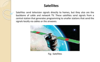
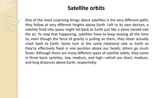
Class Work
6th Class
Satellites
Pranab Bandhu Nath
Senior Lecturer
Dept. of CSE at
City University.
Sanower Hossain Rabbi
ID: 1915002510
Batch: 50th
Program: B.Sc. in CSE
Submitted To: Submitted By :
Satellites send television signals directly to homes, but they also are the
backbone of cable and network TV. These satellites send signals from a
central station that generates programming to smaller stations that send the
signals locally via cables or the airwaves.
Satellites
Fig.: Satellites
A satellite doesn't necessarily have to be a tin can spinning through space.
The word "satellite" is more general than that: it means a smaller, space-
based object moving in a loop (an orbit) around a larger object. The Moon is
a natural satellite of Earth, for example, because gravity locks it in orbit
around our planet. The tin cans we think of as satellites are actually artificial
(human-built) satellites that move in precisely calculated paths, circular or
elliptical (oval), at various distances from Earth, usually well outside its
atmosphere.
Satellites
• Communications Satellite
• Remote Sensing Satellite
• Navigation Satellite
• Geocentric Orbit type staellies - LEO, MEO, HEO
• Global Positioning System (GPS)
• Geostationary Satellites (GEOs)
• Drone Satellite
• Ground Satellite
• Polar Satellite
• Nano Satellites, CubeSats and SmallSat
Types of Satellites
We tend to group satellites either according to the jobs they do or the orbits
they follow. These two things are, however, very closely related, because the
job a satellite does usually determines both how far away from Earth it
needs to be, how fast it has to move, and the orbit it has to follow. The three
main uses of satellites are:
• Communications
• Photography, imaging, and scientific surveying
• Navigation
Satellites Work
Not so many years ago, newspapers used to run scare stories about spy
satellites high in space that could read newspapers over your shoulder.
These days, we all have access to satellite photos, albeit not quite that
detailed: they're built into search engines like Google and Bing, and they
feature routinely on the news and weather forecasts. Scientific satellites
work in a similar way to photographic ones but, instead of capturing simple
visual images, systematically gather other kinds of data over vast areas of
the globe.
Photography, imaging, and scientific surveying
Fig.: Photography, imaging, and scientific surveying
Communications satellites are essentially used to relay radio
waves from one place on Earth to another, catching signals that fire up
to them from a ground station (an Earth-based satellite dish),
amplifying them so they have enough strength to continue (and
modifying them in other ways), and then bouncing them back down to
a second ground station somewhere else.
Communications
Fig.: Communications
Finally, most of us with GPS-enabled cellphones and "sat-nav" devices in our
cars are familiar with the way satellites act like sky compasses; you'll find
GPS, Glonass, and similar systems discussed in much more detail in our
article about satellite navigation.
Navigation
Fig.: Navigation
One of the most surprising things about satellites is the very different paths
they follow at very different heights above Earth. Left to its own devices, a
satellite fired into space might fall back to Earth just like a stone tossed into
the air. To stop that happening, satellites have to keep moving all the time
so, even though the force of gravity is pulling on them, they never actually
crash back to Earth. Some turn at the same rotational rate as Earth so
they're effectively fixed in one position above our heads; others go much
faster. Although there are many different types of satellite orbits, they come
in three basic varieties, low, medium, and high—which are short, medium,
and long distances above Earth, respectively.
Satellite orbits
Scientific satellites tend to be quite close to Earth—often just a few hundred
kilometers up—and follow an almost circular path called a low-Earth orbit
(LEO). Since they have to be moving very fast to overcome Earth's gravity,
and they have a relatively small orbit (because they're so close), they cover
large areas of the planet quite quickly and never stay over one part of Earth
for more than a few minutes. Some follow what's called a polar orbit,
passing over both the North and South poles in a "loop" taking just over an
hour and a half to complete.
Low-Earth orbits
The higher up a satellite is, the longer it spends over any one part of Earth.
It's just the same as jet planes flying over your head: the slower they move
through the sky, the higher up they are. A medium-Earth orbit (MEO) is
about 10 times higher up than a LEO. GPS navstar satellites are in MEO
orbits roughly 20,000 km (12,000 miles) above our heads and take 12 hours
to "loop" the planet. Their orbits are semi-synchronous, which means that,
while they're not always exactly in the same place above our heads, they
pass above the same points on the equator at the same times each day.
Medium-earth orbits
Many satellites have orbits at a carefully chosen distance of about 36,000
km (22,000 miles) from the surface. This "magic" position ensures they take
exactly one day to orbit Earth and always return to the same position above
it, at the same time of day. A high-Earth orbit like this is called
geosynchronous (because it's synchronized with Earth's rotation) or
geostationary (if the satellite stays over the same point on Earth all the
time). Communications satellites—our "space mirrors"—are usually parked
in geostationary orbits so their signals always reach the satellite dishes
pointing up at them. Weather satellites often use geostationary orbits
because they need to keep gathering cloud or rainfall images from the same
broad part of Earth from hour to hour and day to day (unlike LEO scientific
satellites, which gather data from many different places over a relatively
short period of time, geostationary weather satellites gather their data from
a smaller area over a longer period of time).
High-Earth orbits
1. https://www.omicsonline.org/conferences-list/types-of-satellites-and-
applications
2. https://www.britannica.com/science/satellite
3. https://www.space.com/24839-satellites.html
4. https://www.un-spider.org/space-application/satellite-technology
Reference
Thanks Everyone

Satellites

  • 1.
  • 2.
    Pranab Bandhu Nath SeniorLecturer Dept. of CSE at City University. Sanower Hossain Rabbi ID: 1915002510 Batch: 50th Program: B.Sc. in CSE Submitted To: Submitted By :
  • 3.
    Satellites send televisionsignals directly to homes, but they also are the backbone of cable and network TV. These satellites send signals from a central station that generates programming to smaller stations that send the signals locally via cables or the airwaves. Satellites Fig.: Satellites
  • 4.
    A satellite doesn'tnecessarily have to be a tin can spinning through space. The word "satellite" is more general than that: it means a smaller, space- based object moving in a loop (an orbit) around a larger object. The Moon is a natural satellite of Earth, for example, because gravity locks it in orbit around our planet. The tin cans we think of as satellites are actually artificial (human-built) satellites that move in precisely calculated paths, circular or elliptical (oval), at various distances from Earth, usually well outside its atmosphere. Satellites
  • 5.
    • Communications Satellite •Remote Sensing Satellite • Navigation Satellite • Geocentric Orbit type staellies - LEO, MEO, HEO • Global Positioning System (GPS) • Geostationary Satellites (GEOs) • Drone Satellite • Ground Satellite • Polar Satellite • Nano Satellites, CubeSats and SmallSat Types of Satellites
  • 6.
    We tend togroup satellites either according to the jobs they do or the orbits they follow. These two things are, however, very closely related, because the job a satellite does usually determines both how far away from Earth it needs to be, how fast it has to move, and the orbit it has to follow. The three main uses of satellites are: • Communications • Photography, imaging, and scientific surveying • Navigation Satellites Work
  • 7.
    Not so manyyears ago, newspapers used to run scare stories about spy satellites high in space that could read newspapers over your shoulder. These days, we all have access to satellite photos, albeit not quite that detailed: they're built into search engines like Google and Bing, and they feature routinely on the news and weather forecasts. Scientific satellites work in a similar way to photographic ones but, instead of capturing simple visual images, systematically gather other kinds of data over vast areas of the globe. Photography, imaging, and scientific surveying Fig.: Photography, imaging, and scientific surveying
  • 8.
    Communications satellites areessentially used to relay radio waves from one place on Earth to another, catching signals that fire up to them from a ground station (an Earth-based satellite dish), amplifying them so they have enough strength to continue (and modifying them in other ways), and then bouncing them back down to a second ground station somewhere else. Communications Fig.: Communications
  • 9.
    Finally, most ofus with GPS-enabled cellphones and "sat-nav" devices in our cars are familiar with the way satellites act like sky compasses; you'll find GPS, Glonass, and similar systems discussed in much more detail in our article about satellite navigation. Navigation Fig.: Navigation
  • 10.
    One of themost surprising things about satellites is the very different paths they follow at very different heights above Earth. Left to its own devices, a satellite fired into space might fall back to Earth just like a stone tossed into the air. To stop that happening, satellites have to keep moving all the time so, even though the force of gravity is pulling on them, they never actually crash back to Earth. Some turn at the same rotational rate as Earth so they're effectively fixed in one position above our heads; others go much faster. Although there are many different types of satellite orbits, they come in three basic varieties, low, medium, and high—which are short, medium, and long distances above Earth, respectively. Satellite orbits
  • 11.
    Scientific satellites tendto be quite close to Earth—often just a few hundred kilometers up—and follow an almost circular path called a low-Earth orbit (LEO). Since they have to be moving very fast to overcome Earth's gravity, and they have a relatively small orbit (because they're so close), they cover large areas of the planet quite quickly and never stay over one part of Earth for more than a few minutes. Some follow what's called a polar orbit, passing over both the North and South poles in a "loop" taking just over an hour and a half to complete. Low-Earth orbits
  • 12.
    The higher upa satellite is, the longer it spends over any one part of Earth. It's just the same as jet planes flying over your head: the slower they move through the sky, the higher up they are. A medium-Earth orbit (MEO) is about 10 times higher up than a LEO. GPS navstar satellites are in MEO orbits roughly 20,000 km (12,000 miles) above our heads and take 12 hours to "loop" the planet. Their orbits are semi-synchronous, which means that, while they're not always exactly in the same place above our heads, they pass above the same points on the equator at the same times each day. Medium-earth orbits
  • 13.
    Many satellites haveorbits at a carefully chosen distance of about 36,000 km (22,000 miles) from the surface. This "magic" position ensures they take exactly one day to orbit Earth and always return to the same position above it, at the same time of day. A high-Earth orbit like this is called geosynchronous (because it's synchronized with Earth's rotation) or geostationary (if the satellite stays over the same point on Earth all the time). Communications satellites—our "space mirrors"—are usually parked in geostationary orbits so their signals always reach the satellite dishes pointing up at them. Weather satellites often use geostationary orbits because they need to keep gathering cloud or rainfall images from the same broad part of Earth from hour to hour and day to day (unlike LEO scientific satellites, which gather data from many different places over a relatively short period of time, geostationary weather satellites gather their data from a smaller area over a longer period of time). High-Earth orbits
  • 14.
    1. https://www.omicsonline.org/conferences-list/types-of-satellites-and- applications 2. https://www.britannica.com/science/satellite 3.https://www.space.com/24839-satellites.html 4. https://www.un-spider.org/space-application/satellite-technology Reference
  • 15.