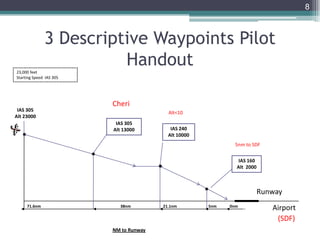
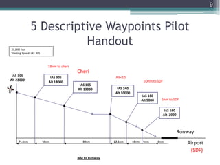
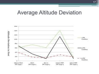
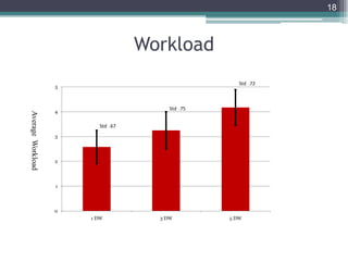
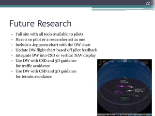
This document summarizes research on using descriptive waypoints to help pilots perform continuous descent approaches more accurately. It describes a study that tested different numbers of descriptive waypoints under varying wind conditions. The results showed that using five descriptive waypoints provided the most structure for pilots and kept aircraft closest to their altitude and speed targets at each waypoint. Pilots also provided feedback that integrating descriptive waypoints into charts and displays could help them manage vertical speed and intercept targets more easily. Future research areas include integrating descriptive waypoints with advanced cockpit systems and using them for traffic and terrain avoidance.
Oral presentation of my final report while attending the National Test Pilot School (NTPS) in Mojave, CA, as a student flight test engineer. Published without corrections.
This is the slideshow that I used while doing my thesis defense for "Analysis, Redesign and Verification of the Iver2 Autonomous Underwater Vehicle Motion Controller."
FM-Basics Topics Wise Solutions | Q & A | Flight Mechanics | GATE AerospaceAge of Aerospace
For Video Lecture of this presentation: https://youtu.be/XNsIdHUx7q8
The topics covered in this session are, Airplane (fixed wing aircraft) configurations and various parts of airplane. A detailed list of airplane configuration is discussed with general insight about airplane parts.
Attention! "Gate Aerospace Engineering aspirants", A virtual guide for gate aerospace engineering is provided in "Age of Aerospace" blog for helping you meticulously prepare for gate examination. Respective notes of individual subjects are provided as 'Embedded Google Docs' which are frequently updated. This comprehensive guide is intended to efficiently serve as an extensive collection of online resources for "GATE Aerospace Engineering" which can be accessed free of cost. Use the following link to access the study material
https://ageofaerospace.blogspot.com/p/gate-aerospace.html
Tutorial VSP Conference 2013, San Luis Obispo, CAHersh Amin
Vehicle Sketch Pad Structure Analysis Module (VSP SAM, http://vspsam.ae.utexas.edu/) tutorial presentation at the 2nd annual VSP (http://openvsp.org/) workshop held in San Luis Obispo, CA from Aug 7-9, 2013.
The presentation summarizes the work on the thesis for investigating different dynamic stall models and their utilization for modeling unsteady aerodynamics for wind turbines.
Thesis: https://www.researchgate.net/profile/Muhammad_Arsalan_Khan2/publication/337466116_Dynamic_Stall_Modelling_for_Wind_Turbines/links/5dd92037a6fdccdb445cb860/Dynamic-Stall-Modelling-for-Wind-Turbines.pdf
Santos, J.S. dos, Lingnau, C., 2013. Monitoring environmental catastrophe area through change detection techniques. CERNE 19, 133–140.
"The use of satellite images has been very effective for monitoring the dynamics of the land use and occupation over
time. For this purpose , the change detection techniques have been strong allies. These techniques have multiple complexities
depending on the objective to be achieved. This study aims to evaluate the technique for land use and land cover changing detection
in areas affected by the environmental disaster of November 2008 in the region of Morro do Baú, Santa Catarina, Brazil. A total
of 04 (four) images from different dates between 1992 and 2009 (post-disaster) were used. The images were processed in
vegetation index using bands 7 and 4 in order to minimize atmospheric and radiometric distortions. Shadow mask, construted
from the digital terrain model, was developed to avoid false changes caused by shade. It was concluded that the georeferencing
must be very accurate in applying these techniques. The vegetation index by using bands 7 and 4and the shadow mask, were
effective in minimizing false changes. It showed that the techniques applied are effective to detect changes in areas affected by the disaster."
07 - NAAONB Conference 2012 - Chris Woodley-Stewart, NAAONB and North Pennine...NAAONB landscapesforlife
Chris Woodley-Stewart, NAAONB Vice Chairman and North Penines AONB Partnership delivered a presentation on LNPs, NIAs and Landscape-scale work in AONBs
Sesion informativa actualizacion sgcc14 control de calidadAudinfor
Ya están disponibles los modelos actualizados del sistema de control de calidad. Los modelos SGCC 14 y SGCC Despachos 14 ya pueden ser descargados desde gesupdate a través de 2 sencillos pasos.
Esta versión del modelo (máster) de manual de control de calidad contiene numerosas modificaciones que es necesario tener en cuenta para que nuestro sistema de control de calidad esté correctamente actualizado.
Cuando descargues el modelo correspondiente a tu manual de calidad (SGCC o SGCC Despachos) encontrarás un fichero excel donde se detallan los cambios realizados para que puedas aplicarlos a tu manual.
QNAP
Servidor NVR dedicado para Gravação Digital
de 24 Câmaras IP das Principais Marcas (65 @
Out/2012), com maior destaque para a Vivotek,
com Servidor Web LINUX integrado.
Permite aceder até o máx. de 120 Câmaras IP
através do endereço IP de um só NVR.
Suporta ligação a Monitor Local até resolução
Full-HD através de 1 saída VGA/HDMI,
Suporta Câmaras Megapixel (até 8Mega)
Inclui 2 portas RJ45 Ethernet Gigabit para LAN
e Backup, podendo usufruir da função de
Transmissão de Vídeo na Web, via Browser IE
ou via Software Centralizado;
Tecnologia Compressão por SW QUAD-CODEC:
H.264, MxPEG, MPEG4 e M-JPEG;
Veloc. Processamento e de Gravação de 600FPS;
Protocolos TCP-IP, DHCP, PPPoE, NTP, UPNP,
HTTP, FTP, SMTP;
Resolução máx.: 8.0 Megapixel;
Suporta 8x Baías de Discos SATA Internos (não
inclui Disco -máx. 3TB), compatível com RAID
0/1/5/6/JBOD; 5 Portas USB para Dispositivos
de Backup Externos, Upgrades de Firmware e
UPS;
Agenda de Backup Remoto em NAS.
Funções de Análise de Vídeo Inteligente
baseadas em Motion Detection no Pós-
Processamento;
Gestão Avançada de Eventos com Notificação
por SMS e E-mail;
E-Map, permitindo digitalizar a Planta do edifício
e adcionar a localização das Câmaras;
Configuração de "n" Perfis de Utilizadores;
Digital Watermarking;
Aplicação para Windows PDA-Phone e Apple
iPhone/iPad/iPod Touch; etc.
Sistema Multi-Lingue.
Dimensões: 200x298x270 mm.
No empty talk.Our work is genuine. Our 'toppers' are real. Our content is king. Judge us before you join us. Most of the questions in IAS 2013 Prelims came from our Online Crash Course. We told you so!
This was my final year project thesis, based on the results from NASA Langley Research Centre’s work on the PRANDTL-D project which was into minimizing the induced drag of a wing body along with elimination of adverse yaw.
The Challenge We Face
Minimal separation and rapid pace.
High-speed operations with little margin for error.
Complex environment.
Low visibility in poor weather.
Combination of Factors Minimizes Safety Margin
Design and analysis of wing for Unmanned Aerial Vehicle using CFDPranit Dhole
Unmanned Aerial Vehicle (UAV) is an important technology for military and security application. Various missions can be done using UAV such as surveillance in unknown areas, forestry conservation, and spying enemy territory. Selection of components such as aerofoil plays huge roll in performers of UAV in terms of lift, drag, load carrying capacity, range etc.
This project presents an approach for designing of wing by selecting proper aerofoil and CFD analysis for verifying aerodynamics characteristics.
High Agility Flight Dynamics and Control of AircraftChirag Sadadiwala
This ppt contains an overview of different types of agility and their dynamics.
Various examples are used to compare agility and super-maneuverability of aircraft.
This is the synopsis presentation that we have present on behalf of the academic staff members of the University of Moratuwa to present our final year project idea, Computational and Experimental Investigation of Aerodynamics of Flapping Airfoils. This basically consists of problem definition, aim, objectives and methodology,
The PROuD project - Flying into the future with the PBN flight procedures PROuD Project
Collection of all the Consortium presentations at the Final Communication Event of the PROuD project, one of the SESAR JU Large Scale Demonstration Activity
International Journal of Engineering Research and Applications (IJERA) is an open access online peer reviewed international journal that publishes research and review articles in the fields of Computer Science, Neural Networks, Electrical Engineering, Software Engineering, Information Technology, Mechanical Engineering, Chemical Engineering, Plastic Engineering, Food Technology, Textile Engineering, Nano Technology & science, Power Electronics, Electronics & Communication Engineering, Computational mathematics, Image processing, Civil Engineering, Structural Engineering, Environmental Engineering, VLSI Testing & Low Power VLSI Design etc.
Enhancing Pilot Ability to Perform Continuous Descent Approach with Descriptive Waypoints
1. Enhancing Pilot Ability to Perform CDA with
Descriptive Waypoints
1
Systems Engineering Research Laboratory
California State University Northridge (CSUN)
10/19/2011
Authors:
Michael LaMarr & Dr. Nhut Ho System Engineering Research Laboratory
Dr. Walter Johnson & Vernol Battiste, NASA AMES
Joe Biviano Lockheed Martin
2. • Previous Research
• Objective
• Method and Experimental Design
• Results
• Conclusion
2
Overview
3. Conventional Approach Vs. Continuous
Descent Approach (CDA)
3
10,000 Feet
4,000 feet
ILS Glide Slope
Runway
Continuous
Descent Approach
Conventional
Approach
Current Problem with Conventional Approach
• Cost of fuel = 27% operation cost to airlines
• People complain about loud aircraft noise near
airports
• Can’t expand runways
• Limited aircraft throughput at night
Implementation challenges for CDA:
•Air Traffic Controllers (ATC) unable to maintain separation between decelerating aircraft
•Pilots have difficulty maintaining a tight vertical flight profile
Proposed Solution Continuous Descent
Approach
• Idle engine at Higher altitude
• Less noise is produced
• Less fuel is consumed ~220lbs
• Fewer emissions produced
21 NM
4. Previous Research
• Structure
▫ Reynolds et. al. (2005)
ATC have difficulty predicting future trajectories of decelerating aircraft
Standardizing CDA deceleration profiles would allow ATC to use structured
based abstractions and maintain aircraft separation
▫ Ho et. al. (2006)
Pilots had highest speed
accuracy with three gates
Having too few or too many
targets could increase workload
4
5. • Vertical Navigation (VNAV) Uncertainty
▫ Clarke, Ho, et. al. (2004)
The altitude constraint has priority over the speed constraint
VNAV performance was dependent on pilot behavior: initiating CDA too late
and delays in flaps deployment negatively affected the desired performance
• 4D Guidance (x, y, z, and Time)
▫ Williams (2008)
Provides an energy cue on a 2D vertical Nav display
NAV display helps pilots manage throttle and speed brake usage during CDA
Helps increase spacing and minimizes Required Time of Arrival deviation
5
Previous Research
6. • To determine the feasibility of using gates for CDA initiated near top
of descent, and number of gates and locations
• Formalize gates as Descriptive Waypoints (DW): A Descriptive
Waypoint is a target along the flight path that gives the pilot a target
altitude and Indicated Airspeed (IAS)
6
Objective
7. 7
23,000 feet
Starting Speed IAS 305
Airport
IAS 160
Alt 2000
5nm71.6nm
NM to Runway
IAS 305
Alt 23000
(SDF)
0nm
5nm to SDF
Runway
1 Descriptive Waypoint Pilot
Handout
8. 8
23,000 feet
Starting Speed IAS 305
Airport
IAS 160
Alt 2000
5nm38nm71.6nm
NM to Runway
IAS 305
Alt 13000
IAS 305
Alt 23000
Cheri
(SDF)
Alt<10
IAS 240
Alt 10000
0nm
5nm to SDF
21.1nm
Runway
3 Descriptive Waypoints Pilot
Handout
9. 9
23,000 feet
Starting Speed IAS 305
Airport
IAS 160
Alt 2000
10nm 5nm22.1nm38nm56nm71.6nm
NM to Runway
IAS 160
Alt 5000
IAS 305
Alt 13000
IAS 305
Alt 18000
IAS 305
Alt 23000
Cheri
(SDF)
Alt<10
18nm to cheri
1Onm to SDF
IAS 240
Alt 10000
0nm
5nm to SDF
Runway
5 Descriptive Waypoints Pilot
Handout
10. Method and Experimental Design
• A 3 x3 within-subject factorial design was used
▫ Number of Descriptive Waypoints: One, Three, and Five
▫ Tail Wind Speed Conditions: Slow, Normal, and High
• Dependent Variables
▫ Deviation from Descriptive Waypoint altitude and Indicated Airspeed
▫ Average power use of aircraft
▫ Workload (Part-task), Pilot acceptance, & Pilot Feedback
10
11. Participants
• Twelve IFR rated pilots with glass cockpit experience with 590 to
23,000 (Mean 7,660) hours flight time
• Eleven males, one female
• Age: 24 to 67, average = 38
• Pilots range from flying 757, CRJ, beachcraft, private jets and a lear
jet
• Two pilots had real world CDA experience, one in a simulator
11
12. Facilities
• Study was run in Systems Engineering Research Laboratory (SERL),
California State University Northridge
• Pilot was in a room with a one-way mirror
• Flight chart was on desk for pilot to use
12
19. Pilot Feedback
• Pilots would feel comfortable (4.42 out of 6 on a scale) having the
DW put into a flight chart
• Pilots would prefer 10-30nm spacing for DW
• Pilots said they would fly more accurate if they had their standard
tools
• Changes recommended from the pilots
▫ DW flight chart should implement distance to each DW and angle of descent
▫ Implementation of DW into vertical NAV display
19
20. Pilot Feedback cont.
• DWs helped them manage their vertical speed by giving them
checkpoints
• DW 3 target at 10,000 feet altitude was seen as the most important
DW by the pilots
• Pilots said they used speed brakes as little as possible
• Responsibilities and tasks for Pilot Flying (PF) and Pilot Monitoring
(PM)
▫ PF should fly vertical speed and IAS, and determine whether the targets at DWs
are met
▫ PF should vocalize plan and callouts to PM
▫ PM should monitor targets, air speed, IAS, and DWs, do all calculations for PF,
setting altitudes, MCP, work the gear and flaps, crosschecking altitude inputs, and
talking to ATC
20
21. • The five DW condition gave structure for the pilots, and the aircraft
consistently flew similar flight paths and were closer to their DW
target altitudes
• The five DW condition used slightly more power (one percent) than
the one and three DW conditions.
▫ With automated assistance such as altitude prediction, pilots believed that they
would intercept DW without resorting to level flight
• The results of increasing performance in the three and five DW
conditions support the use and implementation of DW into CDA
procedures
21
Summary and Conclusion
22. • Full sim with all tools available to pilots
• Have a co pilot or a researcher act as one
• Include a Jeppesen chart with the DW chart
• Update DW flight chart based off pilot feedback
• Integrate DW into CSD or vertical NAV display
• Use DW with CSD and 3D guidance
for traffic avoidance
• Use DW with CSD and 3D guidance
for terrain avoidance
22
Future Research
23. References
• Lowther, M. B., Clarke, J-P., & Ren, L., (2007). En Route Speed Change Optimization for Spacing Continuous
Descent Arrivals
• Reynolds, H., Reynolds, T. & R. Hansman, J. (2005). Human Factors Implications of Continuous Descent
Approach Procedures for Noise Abatement in Air Traffic Control. 6th USA/Europe Air Traffic Management R&D
Seminar, Baltimore, USA, June 27-30.
• Ho, N. T., Clarke, J-P., Riedel, R., & Omen, C. (2006). Development and Evaluation of a Pilot Cueing System for
Near-Term Implementation of Aircraft Noise Abatement Approach Procedures. Journal of American Institute of
Aeronautics and Astronautics.
• Clarke, J-P., B., Ho, N. T., Ren, L., Brown, J. A., Elmer, K. R., Tong, K-O & Wat, J. K. (2004). Continuous Descent
Approach: Design and Flight Test for Louisville International Airport. Journal of Aircraft, 41(5), 1054-1066.
• Reynolds, H. (2006). Modeling the Air Traffic Controller’s Cognitive Projection Process. MIT International
Center for Air Transportation Department of Aeronautics & Astronautics Massachusetts Institute of Technology
Cambridge, MA, 2006
• Stell, L. (2010). Predictability of Top of Descent Location for operational Idle-thrust Descents. American Institute
of Aeronautics and Astronautics.
• Kupfer, M., Callantine, T., Martin, L., Mercer, J. & Palmer, E., 2011, Controller Support Tools for Schedule-Based
Terminal-Area Operations, Ninth USA/Europe Air Traffic Management Research and Development Seminar
(ATM2011)
• Alam, S, Nguyen, M.H., Abbass, H.A., Lokan, C., Ellejmi, M., & Kirby, S., 2010, A Dynamic Continuous Descent
Approach Methodology for Low Noise and Emission, 29th IEEE/AIAA Digital Avionics Systems Conference,
October 3-7, 2010
• Ren, L. & Clark, J-P., 2007, Flight Demonstration of the Separation Analysis Methodology for Continuous Descent
Arrival, Draft paper for 7th USA/Europe ATM 2007 R&D Seminar, Barcelona, Spain, 2-5 July 2007.
23
24. References
• Clark, J-P., Bennett, D., Elmer, K., Firth, J., Hilb, R., Ho, N., Johnson, S., Lau, S., Ren, L., Senechal, D., Sizov, N.,
Slattery, R., Tong, K., Walton, J., Willgruber, A., Williams, D. (2006). Development, Design, and Flight Test
Evaluation of a Continuous Descent Approach Procedure for Nighttime Operation at Louisville International
Airport
• Koeslag, M. F., (1999) Advanced Continuous Descent Approaches –An algorithm design for the Flight
Management System-.
• Moore, S. (2009). Benefits of Highly Predictable Flight Trajectories in Performing Routine Optimized Profile
Descents: Current and Recommended Research. Environmental Working Group Operations Standing Committee
2009 Annual Workshop, NASA Ames.
• Williams, D. (2008). Flight Deck Merging and Spacing and Advanced FMS Operations. EWG Operations
Standing Committee Meeting.
• Coppenbarger, R., Mead, R., Sweet, D., (2009). Field Evaluation of the Tailored Arrivals Concept for Datalink-
Enabled Continuous Descent Approach. Journal of Aircraft, 46(4), July–August 2009
• Global Aviation Navigation, Inc., (2009). Retrieved May 2009, from http://www.globalair.com/d-
TPP_pdf/00239IL17R.PDF
• Thomas, L. & Wickens, C. (2006). Individual Effects of Battlefield Display Frames of Reference on Navigation
Tasks, Spatial Judgments, and Change Detection. Ergonomics, 49, 154-1173.
• Cowen, M., John, M., Oonk, H., & Smallman, H. (2001). The Use of 2D and 3D Displays for Shape-Understanding
versus Relative-Position Tasks. Human Factors, 43(1), 79-98.
• Symmes, D., & Pella, J. (2005). Three-Dimensional Image. Microsoft® Encarta® 2006 [CD]. Redmond, WA:
Microsoft Corporation, 2005.
• Prevot, T., (1998). A Display for Managing the Vertical Flight Path - an Appropriate Task with Inappropriate
Feedback-. International Conference on Human-Computer Interaction in Aeronautics Montreal, Canada, 1998
24
25. 25
References
• Johnson, W., Ho, N., Martin, P., Vu, K-P., Ligda, S., Battiste, V., Lachter, J., Dao, A. (2010), “Management Of
Continuous Descent Approaches During Interval Management Operations,” 29th Digital Avionics Systems
Conference, Salt Lake City, Utah.
• Prevot, T., Callatine, T., Kopardekar, P., Smith, N., Palmer, E., Battiste, V., (2004). Trajectory-Oriented
Operations with Limited Delegation: An Evolutionary Path to NAS Modernization. AIAA 4th Aviation Technology,
Integration and Operations (ATIO) Forum, Chicago, IL, September 2004.