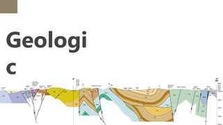
Lesson 38:
Preparation of
Geologic
Section
Geologi
c
Section
Geologic Section
A graphic representation of the intersection of the
geological bodies in the subsurface with a vertical
plane of a certain orientation. It is a section of the
terrain where the different types of rocks, their
location, age, and composition, and the geometric
between them are represented. Which are made on
the basis of geologic maps and data from geologic
mine works, boreholes, geophysical investigations,
Preparation of
Geologic Section
1. Decide what the geologic cross
section is going to be used for, and use
this to guide you in selecting the
appropriate scales.
Preparation of
Geologic Section
2. Choose appropriate vertical
and horizontal scales.
Preparation of
Geologic Section
3. On the map, locate the well or
borehole positions, land service
elevations, depth of the well and the
number of geologic units in each well
bore.
Preparation of
Geologic Section
4. Transfer the geologic information from each will long to the
cross-section. This information represents discrete points of
knowledge about the subsurface geology. Part of the geologist
skills is interpretation from these discrete points of knowledge to
those areas that lie in between. Part of this exercise is
determining what units can be lumped together versus those
which should be spit apart. Again, this mostly related to the
data that is trying to be displayed.
Preparation of
Geologic Section
5. Correlate the geologic information between boreholes. Applying
knowledge of the specific deposition features of the rock or
sediments can be used to increase the accuracy of the model. Look
for differences in lithology, texture, or sediment or rock properties as
a guide to defining contacts between contiguous geologic units. Use
solid lines to indicate reasonably certain relations between discrete
data points. Dashed lines are used to indicate uncertainty or
inferred data. Areas where does not exist are typically labeled with
question marks.
Preparation of
Geologic Section
6. Incorporate Legend, Orientation,
Title, and Scales to the cross-
section. Ensure the units and use
the same colour and pattern
scheme as on the original geologic
map.
Legend – the legend is a key to the patterns used to identify each unit on
the cross-section. The units are ordered from oldest formation at the bottom
of the legend to youngest unit at the top of the legend.
Orientation – the orientation of the cross-section is the direction that the
cross-section line makes on Earth . You can indicate the orientation by
writing the corresponding direction at each end of the cross-section (e.g.,
west and east).
Title – a descriptive title for the cross-section. You can include the letters
used to identify the line on the original geological map in the title.
Scale – include a ratio scale and/or a bar scale to show the scale of the cross-
section. The vertical and horizontal scales should be the same, so you only
need to include one scale on the cross-section.
Strike and
Dip Method
To measure and describe the geometry of geological layers,
geologists apply the concepts of strike and dip.
•Strike refers to the line formed by the intersection of a
horizontal plane and an inclined surface. This line is called
a strike line, and the direction the line points in (either
direction, as a line points in two opposite directions) is the
strike angle.
•Dip is the angle between that horizontal plane (such as
the top of the block in figure 85) and the inclined surface
(such as a geological contact between tilted layers)
measured perpendicular to the strike line down to the
inclined surface.
RELEVANCE
The geological cross-sections have a very
relevant economic and social importance. They
are the basis for planning engineering works,
fundamentally the lineal works that affect the
surface and the subsurface (roads, tunnels,
utilities) and for the exploration and
production of geological resources: water,
stones, minerals and energy.
THANK
YOU!

Preperation of Geologic Section

  • 1.
  • 2.
  • 3.
    Geologic Section A graphicrepresentation of the intersection of the geological bodies in the subsurface with a vertical plane of a certain orientation. It is a section of the terrain where the different types of rocks, their location, age, and composition, and the geometric between them are represented. Which are made on the basis of geologic maps and data from geologic mine works, boreholes, geophysical investigations,
  • 4.
    Preparation of Geologic Section 1.Decide what the geologic cross section is going to be used for, and use this to guide you in selecting the appropriate scales.
  • 5.
    Preparation of Geologic Section 2.Choose appropriate vertical and horizontal scales.
  • 6.
    Preparation of Geologic Section 3.On the map, locate the well or borehole positions, land service elevations, depth of the well and the number of geologic units in each well bore.
  • 7.
    Preparation of Geologic Section 4.Transfer the geologic information from each will long to the cross-section. This information represents discrete points of knowledge about the subsurface geology. Part of the geologist skills is interpretation from these discrete points of knowledge to those areas that lie in between. Part of this exercise is determining what units can be lumped together versus those which should be spit apart. Again, this mostly related to the data that is trying to be displayed.
  • 8.
    Preparation of Geologic Section 5.Correlate the geologic information between boreholes. Applying knowledge of the specific deposition features of the rock or sediments can be used to increase the accuracy of the model. Look for differences in lithology, texture, or sediment or rock properties as a guide to defining contacts between contiguous geologic units. Use solid lines to indicate reasonably certain relations between discrete data points. Dashed lines are used to indicate uncertainty or inferred data. Areas where does not exist are typically labeled with question marks.
  • 9.
    Preparation of Geologic Section 6.Incorporate Legend, Orientation, Title, and Scales to the cross- section. Ensure the units and use the same colour and pattern scheme as on the original geologic map.
  • 10.
    Legend – thelegend is a key to the patterns used to identify each unit on the cross-section. The units are ordered from oldest formation at the bottom of the legend to youngest unit at the top of the legend. Orientation – the orientation of the cross-section is the direction that the cross-section line makes on Earth . You can indicate the orientation by writing the corresponding direction at each end of the cross-section (e.g., west and east). Title – a descriptive title for the cross-section. You can include the letters used to identify the line on the original geological map in the title. Scale – include a ratio scale and/or a bar scale to show the scale of the cross- section. The vertical and horizontal scales should be the same, so you only need to include one scale on the cross-section.
  • 11.
  • 12.
    To measure anddescribe the geometry of geological layers, geologists apply the concepts of strike and dip. •Strike refers to the line formed by the intersection of a horizontal plane and an inclined surface. This line is called a strike line, and the direction the line points in (either direction, as a line points in two opposite directions) is the strike angle. •Dip is the angle between that horizontal plane (such as the top of the block in figure 85) and the inclined surface (such as a geological contact between tilted layers) measured perpendicular to the strike line down to the inclined surface.
  • 13.
    RELEVANCE The geological cross-sectionshave a very relevant economic and social importance. They are the basis for planning engineering works, fundamentally the lineal works that affect the surface and the subsurface (roads, tunnels, utilities) and for the exploration and production of geological resources: water, stones, minerals and energy.
  • 14.