Planet Labs is making use of information gathered from space to help with life on Earth. The group of scientists considered
the problem with most satellites to be their large and clunky form, prompting them to build inexpensive and compact satellites to be manufactured in bulk, called CubeSats.
I make this activity sheet for students who were absent during the lesson so they can make it at home.Please seach LP and PPT for these topic which I also uploaded
The advancement of technology in the last decade or so has allowed astronomy to see exponential growth in data volumes. ESA's space telescope Euclid will gather high-resolution images of a third of the sky, ~850GB of data downloaded daily for 6 years, by 2032 ground-based telescope LSST will have generated 500PB of data and the radio telescope SKA will be producing more data per second than the entire internet worldwide. This talk will address the questions of what current techniques exist to address big data volumes, how the astronomical community will prepare for this big data wave, and what other challenges lie ahead?
Hubble Telescope is used to observe in the near-infrared through the visible spectrum to the ultra-violet.
This Telescope is placed above the distortion of the atmosphere, far above rain clouds and light pollution.
Its advantage to avoid atmospheric turbulence.It has an extremely large field of view which is necessary to obtain high resolution images of large areas of the sky.
How does a Global Navigation Satellite know where it is to tell you where you...OSMFstateofthemap
*** Presented by Martin Wass at State of the Map 2013
*** For the video of this presentation please see http://lanyrd.com/2013/sotm/scpktb/
*** Full schedule available at http://wiki.openstreetmap.org/wiki/State_Of_The_Map_2013
The satellites in Global Navigation Satellite Systems get their position data regularly updated from ground stations. But how do ground stations 'know' where they are, and relative to what? The Airy transit circle at Greenwich once defined the Prime Meridian and the spinning Earth the Equator. We now know the tectonic plate Greenwich sits on is moving and the Earth wobbles... Any defined datum causes difficulties when moving away from the vicinity, say to Mars. Using several different datums raises other problems. When everything is sliding around, how do we define and use a co-ordinate system that works?
1) Earth science is the study ofa. Oceanographyb. Astrono.docxjeremylockett77
1) Earth science is the study of:
a. Oceanography
b. Astronomy
c. Geology
d. All of the above
2) Which of these is a mineral?
a. Granite
b. Oxygen
c. Quartz
d. Proton
3) Electrons have a charge of what?
a. Negative
b. Positive
c. Neutral
d. Credit
4) A mineral is defined as being which of the following
a. Naturally occurring, crystalline structure, solid
b. Naturally occurring, crystalline structure, small
c. Naturally occurring, inorganic, containing quartz
d. Crystalline structure, definite chemical composition, found on Earth’s surface
5) What can an igneous rock’s texture tell us?
a. What its parent rock was
b. How much weathering it has experienced
c. How quickly it cooled
d. How old it is
6) I have a rock made of sea shells. It is:
a. Sedimentary
b. Igneous
c. Metamorphic
d. Obsidian
7) Slump, Debris flow, and Rockslide are all examples of:
a. Mass wasting
b. Surface mining techniques
c. Parts of a river
d. Types of pollution
Go on to next page
8) Most of Earth’s liquid fresh water is located:
a. In lakes
b. In the ground
c. In human made reservoirs
d. In the atmosphere
9) One way to characterize Metamorphic rocks is by their:
a. Foliation
b. Vesicles
c. Location
d. Size
10) A mineral can be classified as being a Silicate or:
a. Sedimentary
b. Igneous
c. Nonsilicate
d. Metamorphic
11) An atom in a covalent bond will:
a. Share its electrons with another atom or atoms
b. Give away its electrons
c. Take electrons
d. Give away a proton
12) An igneous rock that has a low density is likely:
a. Glassy
b. Vesicular
c. Porphyritic
d. Fine grained
13) Where does Carbonic Acid come from?
a. Water and Carbon Dioxide
b. Oxygen and Carbon Dioxide
c. Pollution
d. Limestone
14) Which of the following is most resistant to chemical weathering and erosion?
a. Feldspar
b. Gypsum
c. Halite
d. Clays
15) A material’s ability to transmit fluid is called:
a. Porosity
b. Permeability
c. Aquifer
d. Reservoir
16) An example of a depositional landform from a river is:
a. Delta c. Sink hole
b. Karst d. Tributary
Go on to next page
Part 2: Short Answer. Most answers should take 5-10 words. Each worth 4 points.
17) Describe two uses of minerals.
18) Describe an environment where a coarse grained SEDIMENTARY rock can form.
19) Describe two forms of MECHANICAL weathering.
20) Describe two ways a stream can move material (e.g. sediment and rocks)
21) Pick one of the following “spheres” and describe what it includes: Geosphere, Biosphere, Atmosphere, Hydrosphere. (Your answer should go something like: “The geosphere consists of..” OR it could go like” “The Biosphere consists of…”
22) Describe two characteristics that can help you tell one mineral from another.
23) Describe the difference between Felsic igneous rocks and Mafic igneous rocks.
Go on to next page
24) Using the following figure, describe which minerals will form ...
Metrology is the scientific study of weights and measures. Environmental metrology is the science of using instruments to measure the world around us all. After listening to the presentation, you may continue to click on the remaining slides.
Quiz Sections 1 and 2___1. Japan’s move into China was met by.docxcatheryncouper
Quiz Sections 1 and 2
___1. Japan’s move into China was met by
a. economic sanctions b. threats of war
c. a condemnation d. blockade of Japan’s ports
___2. To avoid war with Germany, Britain and France promised not to
a. join with Russia
b. b. interfere with Italy’s expansion
c. interfere with German annexation of Czechoslovakia
d. join with the United States
___ 3. The ______ pledged to stop the spread of communism.
a. Comintern b. Roosevelt Corolarry
c. Anti-Comintern Pact d. Munich Conference
___4. Stalin signed a nonaggression pact with Germany because
a. he wanted to protect Eastern Europe
b. the Soviet navy needed access to waterways
c. he hoped to prevent the spread of fascism
d. he and Hitler wanted to divide up Eastern Europe
___ 5. Germany’s annexation of Austria violated the
a. Anti-Comintern Pact. b. Treaty of Paris.
c. Congress of Vienna. d. Treaty of Versailles.
___6. Germany and Austria came together because
a. they had signed a pact of union
b. the Austrian people voted for union
c. the German army threatened force
d. Austria attacked Germany
What effect did the union of Germany and Austria have on Europe?
_________________________________________________________________
___ 7. Danzig was important to Germany because
a. It was a growing communist threat
b. It provided access to the Baltic Sea
c. Poland had valuable natural resources
d. It was controlled by France
Why did the German invasion of Danzig provoke war?
_____________________________________________________________
___8. Hitler wanted to annex the Sudetenland because of its
a. river system. b. German origins.
c. alliance with France. d. border with Italy
___9. At the Munich Conference, Chamberlain and Daladier agreed to
a. Hitler’s annexation of the Sudetenland.
b. Italy’s alliance with Germany.
c. disarm Britain and France.
d. protect Czechoslovakia.
___10. Appeasement means to
a. reach a peace agreement.
b. negotiate.
c. give in to some demands to keep the peace.
d. refuse to give in to any demands
11. England and France’s _______________________________ policy led to the fall of Czechoslovakia to the Germans
12.Discuss the role that communism vs. fascism played in World War II? Explain and give some examples.
13. What happened at the Munich Conference and what was the result?
___14. The ___ was an agreement to make war illegal.
a. Munich Pact
b. Soviet Germany non aggression pact
c. Kellogg Brian Pact
d. Roosevelt Corolarry
___15. Defeat of the Loyalists made Francisco Franco the leader of a _____________
16. What kind of government did Franco lead? _____________________
___ 17. In response to Italy invading Ethiopia the League of Nation
a. declared war on Italy b. boycotted trade with Italy
c. assassinated Mussolini d. restricted industry in Italy
Sp11
Name: ________________________________
Lab Report for Lab #1:Motions in the Night Sky and the Celestial Sphere
Part I: Observ ...
Mining Matters Core Concepts are standalone classroom ready activities that reflect key foundational ideas in Earth science. Sourced from our archives of curriculum-linked teacher resources, each activity reflects an integral part of many important concepts and theories in the various disciplines that comprise the Geosciences.
In an effort to be of service to all of our teacher-partners, these activities have been assembled as a way to support individual teachers without the need to attend a pre-requisite teacher training workshop. All the contents of the Core Concepts resource support current teaching practices that values hands-on experience where students take an active role in learning. Any rocks and minerals samples as well as print resources required for successful classroom delivery can be sourced through Mining Matters.
Ethnobotany and Ethnopharmacology:
Ethnobotany in herbal drug evaluation,
Impact of Ethnobotany in traditional medicine,
New development in herbals,
Bio-prospecting tools for drug discovery,
Role of Ethnopharmacology in drug evaluation,
Reverse Pharmacology.
Operation “Blue Star” is the only event in the history of Independent India where the state went into war with its own people. Even after about 40 years it is not clear if it was culmination of states anger over people of the region, a political game of power or start of dictatorial chapter in the democratic setup.
The people of Punjab felt alienated from main stream due to denial of their just demands during a long democratic struggle since independence. As it happen all over the word, it led to militant struggle with great loss of lives of military, police and civilian personnel. Killing of Indira Gandhi and massacre of innocent Sikhs in Delhi and other India cities was also associated with this movement.
The Indian economy is classified into different sectors to simplify the analysis and understanding of economic activities. For Class 10, it's essential to grasp the sectors of the Indian economy, understand their characteristics, and recognize their importance. This guide will provide detailed notes on the Sectors of the Indian Economy Class 10, using specific long-tail keywords to enhance comprehension.
For more information, visit-www.vavaclasses.com
Unit 8 - Information and Communication Technology (Paper I).pdfThiyagu K
This slides describes the basic concepts of ICT, basics of Email, Emerging Technology and Digital Initiatives in Education. This presentations aligns with the UGC Paper I syllabus.
How to Create Map Views in the Odoo 17 ERPCeline George
The map views are useful for providing a geographical representation of data. They allow users to visualize and analyze the data in a more intuitive manner.
This is a presentation by Dada Robert in a Your Skill Boost masterclass organised by the Excellence Foundation for South Sudan (EFSS) on Saturday, the 25th and Sunday, the 26th of May 2024.
He discussed the concept of quality improvement, emphasizing its applicability to various aspects of life, including personal, project, and program improvements. He defined quality as doing the right thing at the right time in the right way to achieve the best possible results and discussed the concept of the "gap" between what we know and what we do, and how this gap represents the areas we need to improve. He explained the scientific approach to quality improvement, which involves systematic performance analysis, testing and learning, and implementing change ideas. He also highlighted the importance of client focus and a team approach to quality improvement.
The Art Pastor's Guide to Sabbath | Steve ThomasonSteve Thomason
What is the purpose of the Sabbath Law in the Torah. It is interesting to compare how the context of the law shifts from Exodus to Deuteronomy. Who gets to rest, and why?
The Art Pastor's Guide to Sabbath | Steve Thomason
Platetectonics review
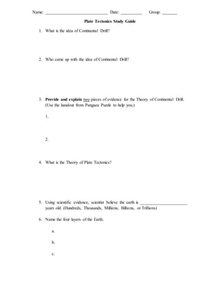
1. Name: _____________________________ Date: __________ Group: _______
Plate Tectonics Study Guide
1. What is the idea of Continental Drift?
2. Who came up with the idea of Continental Drift?
3. Provide and explain two pieces of evidence for the Theory of Continental Drift.
(Use the handout from Pangaea Puzzle to help you.)
1.
2.
4. What is the Theory of Plate Tectonics?
5. Using scientific evidence, scientist believe the earth is ______________________
years old. (Hundreds, Thousands, Millions, Billions, or Trillions)
6. Name the four layers of the Earth.
a.
b.
c.
2. 7. Use the circle below to draw a diagram of the earth’s interior. Label the layers
you listed on the previous page.
8. Give one important fact about each layer of the Earth.
a.
b.
c.
d.
9. What layer(s) of the Earth make up the lithosphere?
10. What layer of the Earth contains the convection currents?
11. Describe how convection currents work.
3. 12. Name the 3 types of plate boundaries.
a.
b.
c.
13. At which plate boundary (ies) are earthquakes formed?
14. At which plate boundary (ies) are volcanoes formed?
15. Name the plate(s) that created the Himalayan Mountains and describe how the
Himalayan Mountains formed.
16. Name the 3 types of volcanoes.
a.
b.
c.
17. Where is the Ring of Fire located?
18. What machine do scientists use to measure earthquakes?
19. What is subduction?
4. 20. At what type of plate boundary does subduction occur?
21. What landform is created by subduction?
22. Where is new lithosphere created?
23. Where is old lithosphere destroyed?
24. What type of scientist uses rocks and fossils to understand when historical events
occurred?
25. Do you think nuclear waste should be stored at Yucca Mountain? State your
decision, give evidence to support your decision and state the trade-off. (Use
Activity 36 to help you answer this question.)