The document discusses factors that affect the speed and volume of rivers as well as processes of erosion and transportation of materials by rivers. It also describes landforms created by river processes such as meanders, ox-bow lakes, floodplains, deltas, and waterfalls. Additionally, it outlines human methods used to control flooding such as river realignment, building dykes and planting vegetation along river banks.
Running water is the primary agent of erosion on Earth's surface, though its role is limited in some glaciated and desert areas. Streams erode through processes like abrasion, attrition, solution, and hydraulic action. As they flow downhill, their kinetic energy is used to transport sediment in suspension, saltation, traction, or solution. When the stream's energy decreases, such as when entering flatter terrain, sediment is deposited in features like point bars, floodplains, levees, meanders, and deltas. Meanders may be cut off over time, forming oxbow lakes.
The document discusses key aspects of river processes and the water cycle. It describes how a river's mouth deposits sediments, flood plains are formed, and a river's middle section contains meanders. It also outlines the different parts of the water cycle from evaporation and condensation to precipitation, groundwater, and transpiration.
The document discusses water resources including surface water and groundwater. It provides background on the water cycle, noting that water is continually moving through different states on Earth. It also discusses the distribution of Earth's water, with only 1% available for human use, mostly as groundwater. The document focuses on the Clear Creek watershed in Texas, describing the watershed area, environmental characteristics, flooding issues, and flood reduction measures. It also discusses uses of surface water and the process of water treatment.
1. The document discusses the hydrologic cycle and how water moves through various pathways between the atmosphere and Earth's surface, including evaporation, condensation, precipitation, and runoff.
2. It describes how runoff water can form streams and tributaries and eventually rivers, and how streams and rivers can deposit sediments to form features like deltas and alluvial fans as they enter lakes and oceans.
3. The document also discusses the formation of landforms like meandering streams, oxbow lakes, and floodplains, and how human activities like adding fertilizers can speed up the natural eutrophication process in lakes.
The hydrologic cycle describes the continuous movement of water above, on, and below the Earth's surface. Water exists in various states as it moves through the cycle, with the driving forces being evaporation, transpiration, condensation, infiltration, and runoff. Precipitation that falls as rain or snow infiltrates into the ground to become groundwater, is taken up by plants, or runs off as surface water into streams, rivers, and lakes, eventually draining into oceans where the cycle begins again through evaporation.
This chapter discusses fluvial processes and landforms created by flowing water. It covers topics like surface runoff, stream systems, drainage basins, stream discharge, erosion and transportation of sediment, channel patterns, and landforms created in different parts of the stream course. It also addresses human impacts like flooding hazards and the importance of surface waters for transportation, agriculture, and water supply.
CAMBRIDGE AS GEOGRAPHY - CASE STUDY: RIVER HARBOURNEGeorge Dumitrache
This case study examines the regular flooding of the village of Harbertonford by the River Harbourne in Devon, England. The river has flooded the village 21 times in the past 60 years due to its flashy nature and the physical geography of its catchment area on Dartmoor. To reduce flooding, a flood storage reservoir and flood defence works were constructed through the village using both hard and soft engineering, including bed lowering, channelization, and storm drains. Flood hazard mapping is also used to identify at-risk areas and plan flood management.
CAMBRIDGE GEOGRAPHY AS - HYDROLOGY AND FLUVIAL GEOMORPHOLOGY: 1.3 RIVER CHANN...George Dumitrache
Subchapter 3 in the first chapter of Hydrology and Fluvial Geomorphology, suitable for AS students, consisting in the following: river processes, velocity, flows and Hjulstrom Curve.
This document discusses various topics related to running water and drainage systems on Earth. It provides details on the water cycle and hydrologic cycle, describing how water moves between the oceans, atmosphere, and land. It also discusses different types of drainage patterns associated with geological features, and how landforms such as valleys, canyons, deltas, and alluvial fans are formed by the erosive power of running water over long periods of time. Monitoring of water levels and flood risks is important for managing water resources and mitigating hazards.
Geography notes Hydrology, Atmosphere, Weathering, Population and Migration
Casestudies aren't included - sorry. Hope these are helpful. Good luck everyone with your exams.
This document discusses river processes and landforms. It begins by explaining the hydrological cycle and components of a drainage basin such as precipitation, evapotranspiration, surface runoff and groundwater flow. River discharge is influenced by several factors like basin size, geology and land use. Meanders, floodplains, levees and deltas are landforms created by fluvial erosion and deposition. The document also examines causes of flooding and different flood management strategies.
This document discusses hydrology and fluvial geomorphology concepts including:
- The water balance and how water moves through drainage basins, including surface storage and groundwater storage.
- How rainfall and basin characteristics influence storm hydrographs and river discharge.
- The different types of water flow through soil and bedrock, including percolation.
- River processes of erosion, transportation, and deposition as well as landforms created by these processes.
- How human activities can impact river flows through changes in land use, water abstraction and storage, and urbanization.
This document discusses drainage basins and the water cycle within a typical basin. It explains that a drainage basin is the area where precipitation flows into a river system. Water enters the basin as precipitation and leaves through evaporation, transpiration, and river discharge. The document outlines the various inputs, storage mechanisms, flows and processes, and outputs involved in the water cycle within a drainage basin. It describes precipitation, interception, vegetation storage, surface storage, groundwater storage, channel storage, and more. Finally, it discusses the water balance of a basin and how inputs and outputs vary seasonally.
CAMBRIDGE AS GEOGRAPHY REVISION: HYDROLOGY AND FLUVIAL GEOMORPHOLOGY - 1.3 RI...George Dumitrache
A presentation of the third subchapter (River Channel Processes) from the first chapter (Hydrology and Fluvial Geomorphology) of Revision for Geography AS Cambridge exam.
Groundwater is saturated rock and soil below the land surface. It is an important source of water for many uses. Water flows through porous materials like sand at different rates depending on the size and number of pores. The majority of groundwater is safe for use despite some texts exaggerating dangers. Groundwater is important for direct use, influencing landscapes, and providing water indirectly through baseflow to streams.
The hydrosphere refers to all water on Earth's surface and near-surface, including oceans, lakes, rivers, groundwater and water in the atmosphere. Oceans contain about 96% of Earth's water while freshwater lakes and streams only contain 0.016%. Groundwater is an important source, with 22% of freshwater occurring underground in aquifers. Aquifers are underground rock formations that hold and transmit water. Factors like porosity, permeability and hydraulic gradient determine groundwater flow. Human activities like excessive groundwater pumping can lower water tables and cause issues like land subsidence, saltwater intrusion and sinkholes. Managing groundwater sustainably requires understanding recharge rates and balancing usage with replenishment
This presentation is a cool resource for doing river revision, especially if you are doing A-levels in Geography.
Here, we will talk about river formation and all related processes that happen with rivers
Streams shape the land through erosion and deposition via fluvial processes. A stream system typically has three courses - upper, middle, and lower. The upper course has steep valleys and gorges due to erosion. The middle course features meandering streams and floodplains. The lower course is dominated by depositional landforms like deltas. A stream erodes until it reaches its base level, which can be an ocean, lake, or resistant rock layer.
Rivers form distinctive landforms through the processes of erosion, transportation, and deposition. Potholes are formed by turbulent water swirling pebbles in a depression, enlarging it over time through abrasion. Rapids occur where bands of hard rock protrude in a river, causing turbulence and mini waterfalls. Waterfalls are formed where a river spills over a sudden change in gradient, undercutting and eroding rocks.
AS Level Physical Geography - Hydrology and Fluvial GeomorphologyArm Punyathorn
Water is an agent of change in the atmosphere, geosphere and biosphere. In this chapter we will try to understand the passage of water as it changes states.We will also look at how the forces of river can shape land forms as well as civilization
Groundwater exploration involves mapping potential aquifer horizons and investigating the saturated zone through field work. Groundwater moves slowly through aquifers compared to surface water. The rate of flow depends on factors like slope of the water table, permeability of the rock, and pressure differences. Effective porosity refers to the volume of pore space that allows water to drain over time under gravity. Darcy's Law is used to calculate groundwater velocity.
Weathering and erosion shape landforms through natural processes. Running water, ice, wind, and gravity cause weathering that breaks down rocks. Erosion then transports eroded material. This degradation and deposition forms many landforms along rivers, including headwaters, valleys, canyons, rapids, waterfalls, meanders, oxbow lakes, floodplains, natural levees, river mouths, and deltas.
Rivers form distinctive landforms through erosion and deposition. In the upper course, valleys and gorges form through erosion in hard rocks. Waterfalls occur where rivers flow over bands of hard and soft rocks. In the middle course, meanders form through lateral erosion and deposition. In the lower course, floodplains and deltas form through deposition as the river speed decreases.
CAMBRIDGE GEOGRAPHY AS - HYDROLOGY AND FLUVIAL GEOMORPHOLOGY; 1.1. DRAINAGE B...George Dumitrache
Introductory presentation of the drainage basin systems in the first chapter of Hydrology and Fluvial Geomorphology, suitable for AS students, consisting in the following: the global hydrological cycle, store, flows, the drainage systems, precipitation, evapotranspiration, interception, infiltration, percolation, drainage patterns, the water balance.
This document presents information about groundwater and aquifers from a student presentation. It defines an aquifer as a saturated, permeable geologic unit that can transmit significant groundwater. It describes different types of aquifers including unconfined, confined, perched, artesian, and leaky aquifers. Examples are given of good aquifers like gravel, sand, and fractured limestone compared to poor aquifers like solid granite with low permeability.
This document provides information about river systems and processes. It discusses the key parts of a river including the upper, middle and lower courses. It describes the landforms associated with each course such as waterfalls in the upper course and meanders and floodplains in the lower course. The document also explains the main river processes of erosion, transportation and deposition and the factors that influence a river's speed and volume.
The document discusses key concepts related to fluvial landforms and their formation by erosion and depositional processes. It focuses on students understanding the relationship between landforms and the fluvial processes that shape them, including the formation of waterfalls, meanders, flood plains, braided channels, levees, and deltas. Key concepts are erosion, deposition, slope erosion, stream erosion, and how these shape features like channels, banks, and overall fluvial landscapes over time.
The document provides information on rivers and river systems for a GCSE geography revision booklet. It includes content on river processes like the hydrological cycle, landforms, and case studies. Key points covered are:
1) The hydrological cycle and how water is transported through the various stages from precipitation to runoff to storage in oceans, groundwater, or glaciers.
2) River landforms that are formed in the upper, middle, and lower courses like meanders, floodplains, and deltas.
3) Two case studies - one on the 2004 Boscastle flood in the UK to illustrate causes, impacts, and management of river flooding in a MEDC, and one on recurring
The document describes various processes involved in river erosion and deposition. It discusses seven transport processes - hydraulic action, abrasion, attrition, solution, traction, saltation, and suspension - that erode and shape the river channel. It also describes deposition occurring when river energy decreases, forming features like deltas and levees. The document contrasts erosion and deposition patterns in the upper, middle, and lower course and discusses landforms formed through vertical erosion like gorges and waterfalls. River channel management techniques are also outlined.
The document discusses several key river processes including erosion, transportation, deposition, and the hydrological cycle. It describes the main forces that shape rivers as they flow downstream such as erosion processes like hydraulic action and abrasion. It also explains how rivers transport sediment loads through traction, saltation, and suspension. Finally, it discusses how and why rivers deposit material based on changes in gradient, volume, and speed.
Stage 1 of river formation involves vertical erosion as potential energy is converted to kinetic energy. Large sediments like boulders are deposited due to low energy levels.
Stage 2 sees increased velocity and lateral erosion as the river gains kinetic energy. Smaller sediments result from attrition in the water allowing more material to be carried downstream.
Stage 3 has high kinetic energy but lower turbulence, so only small particles like silt and sand are deposited on the floodplain during flooding.
1. Rivers carry out three main processes - erosion, transportation, and deposition. Erosion occurs as rivers wear away land, transportation is the movement of eroded sediments downstream, and deposition happens when sediments settle out of the river.
2. The speed of a river's flow is determined by factors like discharge, channel shape, roughness, slope, and gradient. Faster flows lead to turbulent patterns that can transport larger sediments, while slower flows result in deposition of sediments.
3. Rivers erode their channels through hydraulic action, corrasion, attrition, and solution. Sediments are transported in different ways depending on their size - through traction, saltation, or suspension. When flow speeds decrease,
Here are some suggestions for how to represent the river processes visually using diagrams:
Solution - Draw water droplets with dissolved minerals
Suspension - Draw particles floating in the water current
Saltation - Draw particles bouncing along the river bed
Traction - Draw larger particles being rolled along the river bed
You could also draw:
Erosion - Show particles being scraped from the river bed/banks
Transportation - Arrows showing movement of particles downstream
Deposition - Build up of particles settling out of the water
Landforms - Simple sketches of meanders, ox-bow lakes, deltas etc.
Let me know if any of these ideas are helpful or if you need any other suggestions!
Running water is the most powerful natural agent of erosion. It acts almost everywhere on Earth, carrying rock fragments and breaking down the crust through hydraulic action and abrasion. Streams and rivers form complex drainage systems that collectively drain precipitation from drainage basins. As rivers flow from their headwaters to their mouths, their profiles evolve from steep slopes with deep valleys and gorges to flatter slopes with more deposition. Various landforms such as waterfalls, terraces, and canyons are created through the erosive processes of running water.
The document discusses various topics related to river drainage basins and processes:
1. It defines a drainage basin as an area of land drained by a river and its tributaries, with watersheds separating adjacent basins.
2. River patterns like dendritic, trellis, and radial are described as related to the underlying rock types.
3. Factors like river velocity, volume, and energy are discussed in relation to gradient, channel roughness, shape, basin size, vegetation, and climate.
This document discusses river landforms and processes. It begins by defining a river and explaining fluvial processes. It then discusses key aspects of river systems such as tributaries, floodplains, and meanders. Different drainage patterns like dendritic, parallel and trellis are described. The document also covers stream discharge, perennial and non-perennial streams, erosion types, sediment load and transportation methods. Finally, it summarizes the landforms created by upper, middle and lower course rivers such as V-shaped valleys, waterfalls, meanders, ox-bow lakes and deltas.
1. The document defines key terms related to river channel processes including abrasion, attrition, capacity, competence, deltas, discharge, gorges, helicoidal flow, hydraulic action, laminar flow, levees, load, point bars, pools, riffles, river cliffs, solution, turbulent flow, waterfalls, and rapids.
2. It discusses factors that affect rates of erosion in river channels including load, velocity, gradient, geology, pH, and human impact.
3. The main types of river channel flow are laminar, turbulent, and helicoidal flow while channel types include straight, meandering, and braided channels. Meanders have asymmetric cross-sections
The document discusses the fluvial cycle and geological processes of rivers. It begins by introducing geomorphology and defining the fluvial cycle. It then describes the three stages of river development: youth, mature, and old age. Next, it explains the fluvial cycle and the geological actions of rivers, including erosion, transportation, and deposition. It provides details on various erosion features and processes, methods of transportation, and types of depositional features like deltas and alluvial fans. In concluding, the fluvial cycle represents the complete journey of a river from its initial to old stage through the geological processes of erosion, transportation, and deposition.
Waterfalls form where a band of hard rock lies next to soft rock in the upper course of a river. As the river passes over the hard rock, the soft rock below erodes more quickly, undercutting the hard rock. Eventually the hard rock collapses, enlarging the plunge pool beneath through abrasion. As the waterfall retreats upstream through erosion, it forms a steep-walled gorge.
Meanders form as the river's gradient evens out. On the outer bend of a meander, faster flow causes greater erosion and deepening of the channel. On the inner bend, deposition occurs, building up a shallow area called a slip-off slope.
When a river floods and over
This document discusses river landforms and processes. It begins with a longitudinal profile diagram showing how a river's gradient is steepest at the headwaters and gentlest near the base level. It also includes diagrams of drainage patterns and stream order. Common river features are described such as meanders, floodplains, levees, and the formation of ox-bow lakes. The four main methods of river erosion and three methods of sediment transportation are defined. River landforms like waterfalls and pot holes are also examined. The document concludes with descriptions of the different stages in river development from youth to maturity.
1) Floodplains form through erosion and deposition as rivers carry large loads of sediment and widen their valleys over thousands of years.
2) Levees are natural embankments that form along rivers when water moving out of the channel loses energy and deposits heavier sediments along the banks during flooding.
3) Repeated flooding and deposition over time cause levees and floodplains to build up layers of nutrient-rich alluvium soil.
1. Rivers carry loads of materials like rocks, sand, leaves and dead fish. They flow through channels that can have high or low gradients and carry greater or lesser discharges of water.
2. Faster flowing water is able to carry heavier loads, including large bed loads that bounce along the bottom and smaller suspended loads. Chemical dissolved loads are also carried.
3. Rivers progress through youthful, mature and old stages based on factors like climate, gradient and load. Youthful rivers have steep gradients while old rivers are wide and form many meanders.
Hydrology is the study of water on Earth. The key concepts discussed include:
1. The hydrological cycle which describes the continuous movement of water on, above, and below the surface of the Earth.
2. Drainage basins which are areas of land where water from rain or snowmelt drains into a body of water.
3. Factors that influence storm hydrographs such as rock types, basin characteristics, precipitation levels, temperature, and vegetation cover.
1. Meanders form in rivers due to flooding and the occurrence of sand bars, pools, and riffles.
2. Pools and riffles tend to occur regularly, spaced around 5 times the width of the river bed.
3. Secondary flows within the main river flow, like helicoidal flow, erode and deposit material, increasing the sinuosity of the meander over time.
This document outlines key features of river erosion and river systems. It begins with a longitudinal profile diagram showing how a river's gradient is steepest at the headwaters and gentlest near the base level. It then discusses drainage patterns like dendritic and trellis. Common river features like meanders and waterfalls are also explained. The document covers the erosional work of rivers through processes like abrasion and hydraulic action. Methods of sediment transportation like suspension and traction are outlined. Stages in river development from youthful to mature to old age are also summarized.
Similar to Physical GEOG: Chapter 12 - Rivers (20)
GEOG II - Chap 14 - Developments in Food ProductionSofian Muhd
This document provides an overview of developments in food production and their effects. It discusses the intensification of food production through increased irrigation and chemical usage, and the effects this has on soil and water quality like salinization and waterlogging. The document also examines genetically modified (GM) food crops, outlining both their benefits such as increased yields and farmer incomes, as well as threats like loss of biodiversity and potential health risks. Finally, it considers whether ongoing developments in food production will eventually overcome issues of starvation and malnutrition, or if challenges like dominance of agribusinesses and lack of health education will continue to impede progress.
This document discusses variations in global food consumption patterns between developed and less developed countries. It provides several key points:
1) Food consumption varies significantly between DCs and LDCs due to differences in income levels, food availability, and cultural preferences. DCs consume more meat, fruits, and vegetables while LDCs rely more on staple crops.
2) Over time, food consumption patterns have changed as incomes have risen. DCs are eating more variety and healthier options, while LDCs are incorporating more protein. However, instability and affordability continue to influence diets.
3) The main reasons for variations include differences in purchasing power due to economic development levels, stability of food supply affected by disasters and
GEOG II - Chap 09 - Variations in Development in the WorldSofian Muhd
The document provides information on the indicators used to measure development levels between countries. It discusses 10 key indicators across economic, health, and education categories. The economic indicators are income per capita, employment structure, and employment opportunities. The health indicators are life expectancy, infant mortality rate, access to potable water, and sanitation facilities. The education indicators include literacy rate. More developed countries typically demonstrate higher scores on these indicators, such as higher income per capita and life expectancy, compared to less developed countries.
BIO - Chapter 6-9 - Human+Plant Nutrition+TransportSofian Muhd
This document summarizes human nutrition and digestion. It begins with the ingestion of food and outlines the processes of digestion, absorption, assimilation, and egestion. It then describes the organs and structures involved in digestion, including the mouth, esophagus, stomach, pancreas, small intestine, colon, rectum, anus, liver, and salivary glands. It also discusses peristalsis and the roles of enzymes and hormones in breaking down nutrients like carbohydrates, proteins, and fats at different stages of digestion.
BIO - Chapter 2-5 - Cells, Movement of Substances, Nutrients and EnzymesSofian Muhd
1. The document summarizes key organelles and their functions in plant and animal cells. It compares and contrasts the two cell types.
2. Key differences highlighted include the presence of a cell wall and chloroplasts in plant cells and their absence in animal cells.
3. The document also provides information on cell structure and function, including movement of substances via diffusion, osmosis and active transport.
BIO - Chapter 10-13 - Respiration, Excretion, Homeostasis, The Nervous SystemSofian Muhd
The document discusses respiration and the nervous system. It defines respiration as the oxidation of food substances with energy release in cells. It also describes the pathways of nerve impulses from stimulus to response, including sensory neurons, relay neurons in the spinal cord and brain, and motor neurons. Reflexes are defined as immediate responses to stimuli without conscious control, facilitated by reflex arcs from receptor to effector.
GEOG II - Chap 6 - The Tourism IndustrySofian Muhd
Domestic tourism makes up a large portion of tourism revenue for many countries. It provides significant economic benefits as more money is spent within the country rather than leaking out through international travel. Domestic tourism is also important during economic downturns when international travel declines but domestic travel remains affordable for local residents.
GEOG II - Chap 8 - Managing the Impacts of TourismSofian Muhd
Sustainable tourism aims to meet the needs of tourists and hosts while protecting opportunities for future generations. It requires cooperation from various stakeholders including planning authorities, businesses, tourists, and non-governmental organizations. Planning authorities must control development rates and promote sustainable industries. Businesses should minimize environmental impacts and prioritize local communities. Tourists need to respect local cultures. Non-governmental organizations can advocate for conservation and sustainable practices. Ecotourism and community-based tourism, when developed responsibly, can generate local jobs while showcasing natural and cultural heritage. However, all involved must work to avoid overtourism and ensure benefits are shared equitably.
This document provides information on trigonometric functions including definitions of sine, cosine, and tangent at common angles. It also outlines trigonometric identities, addition and double angle formulas, transformations of trig graphs, and the R-formula for expressing combinations of trig functions as a single trig function. Key concepts covered include the unit circle, quadrantal angles, amplitude, frequency, and period as they relate to trigonometric graphs.
The document summarizes various coastal landforms and processes. It describes how factors like wind speed, fetch, and air pressure affect wave size. It explains swash and backwash processes and how they relate to constructive and destructive wave types. It also outlines how coastal landforms like headlands, bays, beaches, cliffs, shore platforms, spits, and tombolos are formed through erosion and deposition processes. Various hard and soft engineering protection methods are also summarized, along with their advantages and disadvantages.
Physical GEOG: Chapter 11 - Deforestation in Kalimantan, IndonesiaSofian Muhd
The document discusses several causes of deforestation in Kalimantan: increased demand for agricultural land from resettlement programs and oil palm plantations; growth of urban settlements and improved transport networks; expansion of industries like logging and mining; and forest fires set by plantation companies. Deforestation leads to loss of biomass and biodiversity, changes in nutrient cycles and water quantity/quality, and air pollution. Government policies to address deforestation include afforestation and reforestation programs, controlled logging, conservation areas, and controlling forest fires, but illegal logging and burning continues.
Physical GEOG: Chapter 10 - Forests as a ResourceSofian Muhd
The document describes various functions and benefits that forests provide, including ecological, economic, and social benefits. Ecologically, forests help maintain water quantity and quality by intercepting rain and reducing runoff, replenish oxygen levels through photosynthesis, maintain soil nutrients, and provide habitat. Economically, forests are a source of useful materials for industry, fuel, food and medicine. They also enable recreation and ecotourism. Socially, forests provide habitat for indigenous people and allow for research and education.
Physical GEOG: Chapter 9 - Types of Nat VegSofian Muhd
The document compares and contrasts the characteristics of 4 forest types: tropical rainforest (TRF), tropical monsoon forest (TMF), mangrove forest (MGR), and coniferous forest (CNF). TRF receives the highest rainfall and has the highest diversity of species. TMF experiences distinct wet and dry seasons and has less dense vegetation than TRF. MGR is found in coastal areas in tropical regions and the trees have adaptations for salty conditions. CNF is located in cool temperate regions, has low plant diversity, and the trees have needle-like leaves and thick bark.
Physical GEOG: Chapter 8 - Floods and DroughtsSofian Muhd
Floods can be caused by excessive rainfall, melting snow, storm surges, and global atmospheric processes like El Niño. Examples include annual flooding of the Yangtze and Yellow Rivers in China due to heavy rainfall and sediment deposition, and flooding in Peru from prolonged heavy rains during the 1997-1998 El Niño event. Clearing of forests and urban development can also lead to increased flooding by reducing ground absorption and increasing surface runoff into rivers.
Physical GEOG: Chapter 6 - Elements of WeatherSofian Muhd
The document discusses factors that affect temperature such as latitude, altitude, distance from the sea, cloud cover, and ocean currents. It then provides examples of how these factors influence the climate in different locations. The document also describes the formation processes of different types of rain including convectional rain, relief/orographic rain, and the southwest and northeast monsoons in Asia.
An earthquake is caused by a sudden release of energy stored in the Earth's crust along a fault line. The focus is the point of energy release within the crust, while the epicenter is the point directly above the focus on the surface. When plate movements cause built-up stress to exceed rocks' limits, the stored energy is released as seismic waves, causing the ground to vibrate and potentially damage infrastructure through collapse or landslides. Earthquakes can also indirectly cause fires, tsunamis, and other hazards.
Folding and faulting are two types of mountain formation that occur at convergent plate boundaries as layers of rock are compressed from plate collisions, causing rock strata to buckle and fold into fold mountains or become displaced along fault lines to form block mountains and rift valleys. Volcanoes and earthquakes predominantly occur along plate boundaries where plates are diverging, converging, or moving past each other laterally. Different types of volcanoes have characteristic shapes, eruption styles, and ejecta depending on the viscosity of the lava and whether eruptions are violent or non-violent.
The Earth is composed of four main layers from the innermost outwards: the core, mantle, crust, and lithosphere. The core is mostly iron and nickel with a temperature between 3000-5000°C. The mantle is between 1400-3000°C and composed of solid and molten rocks. The crust varies in thickness and composition depending on if it is continental or oceanic. The lithosphere is made up of tectonic plates that are constantly shifting. When plates diverge they form mid-ocean ridges, when they converge they can form subduction zones, volcanoes, and mountains, and when they move past each other they form transform boundaries often along fault lines.
The document summarizes chapters from a biology textbook covering various body systems including excretion, homeostasis, the nervous system, and the human eye. The key points are:
1. Excretion is the removal of waste from the body through organs like the skin, kidneys, and lungs.
2. Homeostasis maintains a constant internal environment through a stimulus, receptor, response, and negative feedback loop.
3. The nervous system detects stimuli through receptors and causes responses through effectors in reflex arcs to coordinate body functions.
4. The eye contains structures like the cornea, iris, pupil, eyelids, and tear glands that work together to allow vision.
The document summarizes chapters from a biology textbook covering various body systems including excretion, homeostasis, the nervous system, and the human eye.
The key points are: Excretion removes waste from the body through organs like the skin, kidneys, and lungs. Homeostasis maintains a stable internal environment through stimuli, receptors, responses, and feedback. The nervous system coordinates body functions through neurons, reflex arcs, and pathways between receptors and effectors. Finally, the eye contains structures like the cornea, iris, retina, and tear glands that work together to take in light and produce vision.
[OReilly Superstream] Occupy the Space: A grassroots guide to engineering (an...Jason Yip
The typical problem in product engineering is not bad strategy, so much as “no strategy”. This leads to confusion, lack of motivation, and incoherent action. The next time you look for a strategy and find an empty space, instead of waiting for it to be filled, I will show you how to fill it in yourself. If you’re wrong, it forces a correction. If you’re right, it helps create focus. I’ll share how I’ve approached this in the past, both what works and lessons for what didn’t work so well.
Generating privacy-protected synthetic data using Secludy and MilvusZilliz
During this demo, the founders of Secludy will demonstrate how their system utilizes Milvus to store and manipulate embeddings for generating privacy-protected synthetic data. Their approach not only maintains the confidentiality of the original data but also enhances the utility and scalability of LLMs under privacy constraints. Attendees, including machine learning engineers, data scientists, and data managers, will witness first-hand how Secludy's integration with Milvus empowers organizations to harness the power of LLMs securely and efficiently.
For the full video of this presentation, please visit: https://www.edge-ai-vision.com/2024/06/temporal-event-neural-networks-a-more-efficient-alternative-to-the-transformer-a-presentation-from-brainchip/
Chris Jones, Director of Product Management at BrainChip , presents the “Temporal Event Neural Networks: A More Efficient Alternative to the Transformer” tutorial at the May 2024 Embedded Vision Summit.
The expansion of AI services necessitates enhanced computational capabilities on edge devices. Temporal Event Neural Networks (TENNs), developed by BrainChip, represent a novel and highly efficient state-space network. TENNs demonstrate exceptional proficiency in handling multi-dimensional streaming data, facilitating advancements in object detection, action recognition, speech enhancement and language model/sequence generation. Through the utilization of polynomial-based continuous convolutions, TENNs streamline models, expedite training processes and significantly diminish memory requirements, achieving notable reductions of up to 50x in parameters and 5,000x in energy consumption compared to prevailing methodologies like transformers.
Integration with BrainChip’s Akida neuromorphic hardware IP further enhances TENNs’ capabilities, enabling the realization of highly capable, portable and passively cooled edge devices. This presentation delves into the technical innovations underlying TENNs, presents real-world benchmarks, and elucidates how this cutting-edge approach is positioned to revolutionize edge AI across diverse applications.
For the full video of this presentation, please visit: https://www.edge-ai-vision.com/2024/06/how-axelera-ai-uses-digital-compute-in-memory-to-deliver-fast-and-energy-efficient-computer-vision-a-presentation-from-axelera-ai/
Bram Verhoef, Head of Machine Learning at Axelera AI, presents the “How Axelera AI Uses Digital Compute-in-memory to Deliver Fast and Energy-efficient Computer Vision” tutorial at the May 2024 Embedded Vision Summit.
As artificial intelligence inference transitions from cloud environments to edge locations, computer vision applications achieve heightened responsiveness, reliability and privacy. This migration, however, introduces the challenge of operating within the stringent confines of resource constraints typical at the edge, including small form factors, low energy budgets and diminished memory and computational capacities. Axelera AI addresses these challenges through an innovative approach of performing digital computations within memory itself. This technique facilitates the realization of high-performance, energy-efficient and cost-effective computer vision capabilities at the thin and thick edge, extending the frontier of what is achievable with current technologies.
In this presentation, Verhoef unveils his company’s pioneering chip technology and demonstrates its capacity to deliver exceptional frames-per-second performance across a range of standard computer vision networks typical of applications in security, surveillance and the industrial sector. This shows that advanced computer vision can be accessible and efficient, even at the very edge of our technological ecosystem.
Essentials of Automations: Exploring Attributes & Automation ParametersSafe Software
Building automations in FME Flow can save time, money, and help businesses scale by eliminating data silos and providing data to stakeholders in real-time. One essential component to orchestrating complex automations is the use of attributes & automation parameters (both formerly known as “keys”). In fact, it’s unlikely you’ll ever build an Automation without using these components, but what exactly are they?
Attributes & automation parameters enable the automation author to pass data values from one automation component to the next. During this webinar, our FME Flow Specialists will cover leveraging the three types of these output attributes & parameters in FME Flow: Event, Custom, and Automation. As a bonus, they’ll also be making use of the Split-Merge Block functionality.
You’ll leave this webinar with a better understanding of how to maximize the potential of automations by making use of attributes & automation parameters, with the ultimate goal of setting your enterprise integration workflows up on autopilot.
HCL Notes und Domino Lizenzkostenreduzierung in der Welt von DLAUpanagenda
Webinar Recording: https://www.panagenda.com/webinars/hcl-notes-und-domino-lizenzkostenreduzierung-in-der-welt-von-dlau/
DLAU und die Lizenzen nach dem CCB- und CCX-Modell sind für viele in der HCL-Community seit letztem Jahr ein heißes Thema. Als Notes- oder Domino-Kunde haben Sie vielleicht mit unerwartet hohen Benutzerzahlen und Lizenzgebühren zu kämpfen. Sie fragen sich vielleicht, wie diese neue Art der Lizenzierung funktioniert und welchen Nutzen sie Ihnen bringt. Vor allem wollen Sie sicherlich Ihr Budget einhalten und Kosten sparen, wo immer möglich. Das verstehen wir und wir möchten Ihnen dabei helfen!
Wir erklären Ihnen, wie Sie häufige Konfigurationsprobleme lösen können, die dazu führen können, dass mehr Benutzer gezählt werden als nötig, und wie Sie überflüssige oder ungenutzte Konten identifizieren und entfernen können, um Geld zu sparen. Es gibt auch einige Ansätze, die zu unnötigen Ausgaben führen können, z. B. wenn ein Personendokument anstelle eines Mail-Ins für geteilte Mailboxen verwendet wird. Wir zeigen Ihnen solche Fälle und deren Lösungen. Und natürlich erklären wir Ihnen das neue Lizenzmodell.
Nehmen Sie an diesem Webinar teil, bei dem HCL-Ambassador Marc Thomas und Gastredner Franz Walder Ihnen diese neue Welt näherbringen. Es vermittelt Ihnen die Tools und das Know-how, um den Überblick zu bewahren. Sie werden in der Lage sein, Ihre Kosten durch eine optimierte Domino-Konfiguration zu reduzieren und auch in Zukunft gering zu halten.
Diese Themen werden behandelt
- Reduzierung der Lizenzkosten durch Auffinden und Beheben von Fehlkonfigurationen und überflüssigen Konten
- Wie funktionieren CCB- und CCX-Lizenzen wirklich?
- Verstehen des DLAU-Tools und wie man es am besten nutzt
- Tipps für häufige Problembereiche, wie z. B. Team-Postfächer, Funktions-/Testbenutzer usw.
- Praxisbeispiele und Best Practices zum sofortigen Umsetzen
Freshworks Rethinks NoSQL for Rapid Scaling & Cost-EfficiencyScyllaDB
Freshworks creates AI-boosted business software that helps employees work more efficiently and effectively. Managing data across multiple RDBMS and NoSQL databases was already a challenge at their current scale. To prepare for 10X growth, they knew it was time to rethink their database strategy. Learn how they architected a solution that would simplify scaling while keeping costs under control.
Dandelion Hashtable: beyond billion requests per second on a commodity serverAntonios Katsarakis
This slide deck presents DLHT, a concurrent in-memory hashtable. Despite efforts to optimize hashtables, that go as far as sacrificing core functionality, state-of-the-art designs still incur multiple memory accesses per request and block request processing in three cases. First, most hashtables block while waiting for data to be retrieved from memory. Second, open-addressing designs, which represent the current state-of-the-art, either cannot free index slots on deletes or must block all requests to do so. Third, index resizes block every request until all objects are copied to the new index. Defying folklore wisdom, DLHT forgoes open-addressing and adopts a fully-featured and memory-aware closed-addressing design based on bounded cache-line-chaining. This design offers lock-free index operations and deletes that free slots instantly, (2) completes most requests with a single memory access, (3) utilizes software prefetching to hide memory latencies, and (4) employs a novel non-blocking and parallel resizing. In a commodity server and a memory-resident workload, DLHT surpasses 1.6B requests per second and provides 3.5x (12x) the throughput of the state-of-the-art closed-addressing (open-addressing) resizable hashtable on Gets (Deletes).
Monitoring and Managing Anomaly Detection on OpenShift.pdfTosin Akinosho
Monitoring and Managing Anomaly Detection on OpenShift
Overview
Dive into the world of anomaly detection on edge devices with our comprehensive hands-on tutorial. This SlideShare presentation will guide you through the entire process, from data collection and model training to edge deployment and real-time monitoring. Perfect for those looking to implement robust anomaly detection systems on resource-constrained IoT/edge devices.
Key Topics Covered
1. Introduction to Anomaly Detection
- Understand the fundamentals of anomaly detection and its importance in identifying unusual behavior or failures in systems.
2. Understanding Edge (IoT)
- Learn about edge computing and IoT, and how they enable real-time data processing and decision-making at the source.
3. What is ArgoCD?
- Discover ArgoCD, a declarative, GitOps continuous delivery tool for Kubernetes, and its role in deploying applications on edge devices.
4. Deployment Using ArgoCD for Edge Devices
- Step-by-step guide on deploying anomaly detection models on edge devices using ArgoCD.
5. Introduction to Apache Kafka and S3
- Explore Apache Kafka for real-time data streaming and Amazon S3 for scalable storage solutions.
6. Viewing Kafka Messages in the Data Lake
- Learn how to view and analyze Kafka messages stored in a data lake for better insights.
7. What is Prometheus?
- Get to know Prometheus, an open-source monitoring and alerting toolkit, and its application in monitoring edge devices.
8. Monitoring Application Metrics with Prometheus
- Detailed instructions on setting up Prometheus to monitor the performance and health of your anomaly detection system.
9. What is Camel K?
- Introduction to Camel K, a lightweight integration framework built on Apache Camel, designed for Kubernetes.
10. Configuring Camel K Integrations for Data Pipelines
- Learn how to configure Camel K for seamless data pipeline integrations in your anomaly detection workflow.
11. What is a Jupyter Notebook?
- Overview of Jupyter Notebooks, an open-source web application for creating and sharing documents with live code, equations, visualizations, and narrative text.
12. Jupyter Notebooks with Code Examples
- Hands-on examples and code snippets in Jupyter Notebooks to help you implement and test anomaly detection models.
Introduction of Cybersecurity with OSS at Code Europe 2024Hiroshi SHIBATA
I develop the Ruby programming language, RubyGems, and Bundler, which are package managers for Ruby. Today, I will introduce how to enhance the security of your application using open-source software (OSS) examples from Ruby and RubyGems.
The first topic is CVE (Common Vulnerabilities and Exposures). I have published CVEs many times. But what exactly is a CVE? I'll provide a basic understanding of CVEs and explain how to detect and handle vulnerabilities in OSS.
Next, let's discuss package managers. Package managers play a critical role in the OSS ecosystem. I'll explain how to manage library dependencies in your application.
I'll share insights into how the Ruby and RubyGems core team works to keep our ecosystem safe. By the end of this talk, you'll have a better understanding of how to safeguard your code.
Digital Banking in the Cloud: How Citizens Bank Unlocked Their MainframePrecisely
Inconsistent user experience and siloed data, high costs, and changing customer expectations – Citizens Bank was experiencing these challenges while it was attempting to deliver a superior digital banking experience for its clients. Its core banking applications run on the mainframe and Citizens was using legacy utilities to get the critical mainframe data to feed customer-facing channels, like call centers, web, and mobile. Ultimately, this led to higher operating costs (MIPS), delayed response times, and longer time to market.
Ever-changing customer expectations demand more modern digital experiences, and the bank needed to find a solution that could provide real-time data to its customer channels with low latency and operating costs. Join this session to learn how Citizens is leveraging Precisely to replicate mainframe data to its customer channels and deliver on their “modern digital bank” experiences.
Driving Business Innovation: Latest Generative AI Advancements & Success StorySafe Software
Are you ready to revolutionize how you handle data? Join us for a webinar where we’ll bring you up to speed with the latest advancements in Generative AI technology and discover how leveraging FME with tools from giants like Google Gemini, Amazon, and Microsoft OpenAI can supercharge your workflow efficiency.
During the hour, we’ll take you through:
Guest Speaker Segment with Hannah Barrington: Dive into the world of dynamic real estate marketing with Hannah, the Marketing Manager at Workspace Group. Hear firsthand how their team generates engaging descriptions for thousands of office units by integrating diverse data sources—from PDF floorplans to web pages—using FME transformers, like OpenAIVisionConnector and AnthropicVisionConnector. This use case will show you how GenAI can streamline content creation for marketing across the board.
Ollama Use Case: Learn how Scenario Specialist Dmitri Bagh has utilized Ollama within FME to input data, create custom models, and enhance security protocols. This segment will include demos to illustrate the full capabilities of FME in AI-driven processes.
Custom AI Models: Discover how to leverage FME to build personalized AI models using your data. Whether it’s populating a model with local data for added security or integrating public AI tools, find out how FME facilitates a versatile and secure approach to AI.
We’ll wrap up with a live Q&A session where you can engage with our experts on your specific use cases, and learn more about optimizing your data workflows with AI.
This webinar is ideal for professionals seeking to harness the power of AI within their data management systems while ensuring high levels of customization and security. Whether you're a novice or an expert, gain actionable insights and strategies to elevate your data processes. Join us to see how FME and AI can revolutionize how you work with data!
How to Interpret Trends in the Kalyan Rajdhani Mix Chart.pdfChart Kalyan
A Mix Chart displays historical data of numbers in a graphical or tabular form. The Kalyan Rajdhani Mix Chart specifically shows the results of a sequence of numbers over different periods.
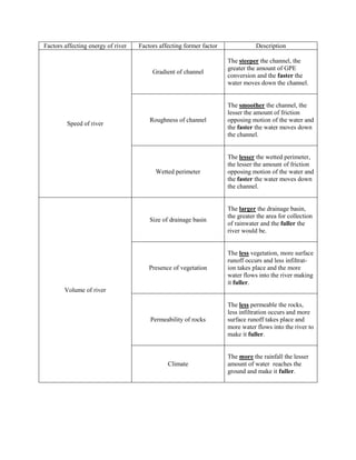
1. Factors affecting energy of river Factors affecting former factor Description
The steeper the channel, the
greater the amount of GPE
Gradient of channel
conversion and the faster the
water moves down the channel.
The smoother the channel, the
lesser the amount of friction
Roughness of channel opposing motion of the water and
Speed of river
the faster the water moves down
the channel.
The lesser the wetted perimeter,
the lesser the amount of friction
Wetted perimeter opposing motion of the water and
the faster the water moves down
the channel.
The larger the drainage basin,
the greater the area for collection
Size of drainage basin
of rainwater and the fuller the
river would be.
The less vegetation, more surface
runoff occurs and less infiltrat-
Presence of vegetation ion takes place and the more
water flows into the river making
it fuller.
Volume of river
The less permeable the rocks,
less infiltration occurs and more
Permeability of rocks surface runoff takes place and
more water flows into the river to
make it fuller.
The more the rainfall the lesser
Climate amount of water reaches the
ground and make it fuller.
2. Process Subprocess Description
Agent: Running water
Force of fast moving water
Hydraulic action loosens rocks and soil along river
banks and bed, are soon dis-
lodged.
Agent: River bed and sides
When rock fragments are
Abrasion dragged along the river bed or
against the sides of the river,
grinding action causes widening
and deepening of channel.
Erosion
Agent: Other eroded particles
Eroded materials collide against
Attrition one another and this breaks them
down into smaller pieces, larger
rocks are slowly broken down,
rough edges are smoothened.
Agent: Carbonic acid
CO2 reacts with H2O to form
Solution H2CO3. When river flows over
limestone, carbonation occurs
and the acid dissolves the lime-
stone.
Heaviest materials tpted this way.
Traction
Dragged/rolled along river.
2nd heaviest tpt this way.
Saltation
Series of bouncing motions.
Transportation
Lightest materials tpted this way.
Suspension
“Float” along in water.
Soluble subs tpted this way.
Solution Transporting of dissolved
materials.
3. Factors that can cause deposition:
1. During low precipitation
2. River enters lake or sea,
decrease in speed
Deposition ------- 3. Increased friction with river
sides, decreasing the speed
4. Sudden increase in load, esp
during landslides
5.Obstructions (eg. aquatic life)
are present
DEPOSITION:
Small decrease in speed of river enables large
particles to be deposited while a large decrease
in speed enables smaller particles to be
deposited.
TRANSPORTATION:
Large particles require high river speeds to
transport them while smaller particles require
small river speeds to transport them.
EROSION:
From 0.5mm onwards, more energy is required
to erode the particle. Below 0.5mm, more
energy is required to erode them as these fine
particles are highly cohesive and they stick to
each other hence a large amount of energy is needed to dislodge them away from each other.
Formation of waterfall
1. When a river flows over rocks of different resistance, the less resistant rock is eroded far more
than the more resistant rock, causing a change in gradient of the river course. Over time, the river
plunges from a great height to hit the river below with tremendous force. A waterfall forms as a
results. Repeated poundings of the river bed may leave a depression at the base of the waterfall.
This depression is deepened as rocks and boulders swirl around forming a plunge pool.
4. 2. Due to the displacement of rocks, there is a difference in height between the two rocks. Water
cascades down the scarp to hit the lower rock. Repeated poundings of the river bed may leave a
depression at the base of the waterfall. This depression is deepened as rocks and boulders swirl
around forming a plunge pool.
Formation of gorges
When a river flows through an area with resistant rocks by its sides, it can only erode its channel
vertically. Over time, a deep, narrow and steep-sided valley known as a gorge is formed.
Formation of valleys
Upper course valley:
Gradient is steep hence it has sufficient energy to erode the rocks in its path and cut deep into the
channel. A V-shaped, narrow and steep-sided valleys are formed.
Middle course valley:
Gradient is not that steep hence it flows with less energy and cuts less deeply into its channel.
Lateral erosion is more dominant than vertical erosion hence it is wider.
Lower course valley:
Exceptionally wide because gradient is gentle. Lateral erosion is dominant giving rise to a broad,
flat-floored valley.
Formation of floodplains and natural levees
When there is heavy rain, a river may overflow its banks. This causes land on either sides of the
river to be flooded. As floodwater spread over large areas, it loses speed. When the floodwaters
recedes, the river deposits the material it is carrying on the land, leaving behind alluvium on the
river banks. Coarser sediments end up nearer the banks as they weigh more hence the
accumulation of these sediments form natural levees while the wide flat plains are the floodplains.
5. Formation of meanders and ox-bow lakes
In the outer bend of a river, the river flows faster than in the inner bend as there is less friction
against the water and the river sides. This causes erosion to occur in the outer bend due to high
speeds and deposition to occur in the inner bend due to the slows speeds. When more sediments
are eroded on the outer bend and more sediments are deposited on the inner bend, the river
become more curved, forming meanders.
With continual erosion and deposition, the meanders become more pronounced and curved
towards each other and a narrow neck of land forms in between the curve. With even more
deposition and erosion, the meanders will meet and soon damn up the water in the cut-off
forming an ox-bow lake. The water in the lake will soon evaporate away.
Formation of deltas
When a river approaches a sea, its speed decreases. Thus it deposits its sediments at the river
mouth. If the rate of deposition is greater than the removal of the sediments, they will accumulate
and build up at the river mouth. A delta is formed. When more alluvium is deposited, the delta
extends seawards and smaller channels known as distributaries are formed.
6. Method Description + - Example
Straightening of river Reduces chances Flooding down-
channel by removing of flood as there is stream may
meanders and curves in no chance for occur as these
the river. Reduces length deposition to eroded sedi-
River re-
of river. reduce depth of ments would be -------
alignment
river. deposited at the
lower course
where speed is
slow.
Widening and deepening Reduces chances Expensive to The Singapore
of the river channel to of flood as more carry out and it is River has been
increase ability to water is required not possible for re-sectioned
contain water. Wetted to cause the flood. LDCs to afford. during the post-
Re-sectioning perimeter is smoothened Difficult to carry independence
with cement and granite. out in urban years to increase
areas as there is the volume of the
a high demand river.
for land.
Walls of sand, stone and Reduces chances Easily over- China has built
concrete built along river of flood as more topped by a dykes along the
banks to increase water is required larger flood, Yellow River but
capacity of river. to cause the flood. expensive to has failed due to
construct and constant
Dykes
maintain. deposition of
sediments in the
river bed that
decreases the
depth.
Metal cages filled with Divert the flow of Metal cages rust
rocks placed at the river water to the cen- easily and when
sides. tre of the channel they are spoilt,
to prevent erosion they are useless.
Gabions
of the river sides, Short term pro- --------
no deposition of tection.
sediments to cause
floods.
Walls made up of large Divert the flow of Undermining of
stones that line the banks water to the cen- base of revet-
of a river. tre of the channel ments cause it to
to prevent erosion collapse
Revetments --------
of the river sides, eventually.
no deposition of
sediments to cause
floods.
7. Roots of trees hold the Channel does not Trees might Royal Forest
soil together firmly. Veg become shallower block the Department
slows down rate of hence chance of sunlight from (RFD) in
surface runoff, preventing flood is reduced. other aquatic Thailand came
Planting
large amounts of water plants in the up with
vegetations
from entering the river. river, affecting watershed
Decreases amount of the river management
eroded sediments into the ecosystem. programme to
river. prevent floods.