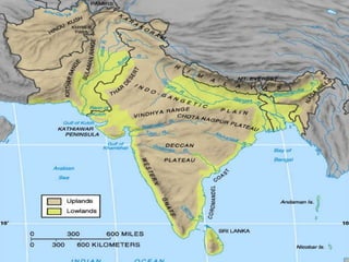
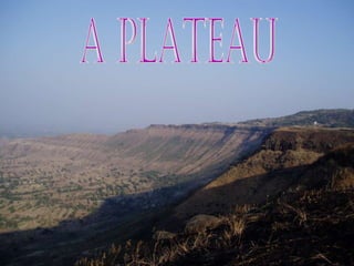
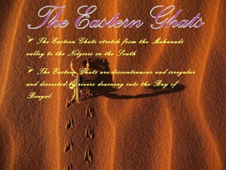
Peninsular Plateau of India by Sidharth p. Grade-9
The Peninsular plateau The peninsular plateau is a tableland composed of the old crystalline, igneous and metamorphic rocks. It was formed due to the breaking and drifting of the Gondwanaland and thus making it a part of the oldest landmass. This plateau consists of two broad divisions: Central highlands  Deccan plateau.
The central Highlands The part of Peninsular plateau lying to the north of the Narmada river covering a major area of the Malwa plateau is known as the Central Highlands. The Vindhyan range is bounded by the central Highlands on the south and the Aravalis on the northwest. The further westward extension gradually merges with the sandy and rocky desert of Rajasthan.
Continued... The flow of rivers draining this region, namely the Chambal, the Sind, the Betwa and Ken is from southwest to northeast, thus indicating the slope. The central Highlands are wider in the west but narrower in the east. Eastward extention: 1. Bundelkhand 2. Baghelkhand 3. The Chotanagpur plateau drained by  Damodar river.
The Deccan Plateau The Deccan Plateau is a triangular landmass that lies to the south of the river Narmada.  Northern Deccan: 1. Satpura Range flanks. Eastern Deccan:  1. The Mahadev 2. The Kaimur hills 3. Maikal range
Continued... It extends over eight Indian states and encompasses a wide range of habitats, covering most of central and southern India. It is located between three mountain ranges: the Western Ghats form its western boundary, and the Eastern Ghats its eastern boundary.   An extension of the plateau is also visible in the northeast- locally known as the Meghalaya, Karbi-Anglong Plateau and North cacher hills. It is separated by a fault from the Chotanagpur Plateau. Three prominent hills ranges from the west to east are the Garo, the Khasi and the Jaintia hills.
Western Ghats Western Ghats lie parellel to the western coast They are continuous and can be crossed through passes only. Western Ghats are higher than Eastern Ghats.  The average elevation is 900 – 1600 mts.
The Eastern Ghats The Eastern Ghats stretch from the Mahanadi valley to the Nilgiris in the South The Eastern Ghats are discontinuous and irregular and dissected by rivers draining into the Bay of Bengal.
Peaks.... Anai Mudi  – 2695mts [Western Ghats.] Doda Beta  – 2637mts [Western Ghats.] Mahendragiri  – 1501mts [Eastern Ghats.]
Hills... Shevroy hills Javadi Hills These are located in Southeast of Eastern Ghats. Hill stations... Kodaikanal Ooty [Udagamandalam]
 
 
A TableLand
A plateau
THANK YOU

Peninsular plateau

  • 1.
    Peninsular Plateau ofIndia by Sidharth p. Grade-9
  • 2.
    The Peninsular plateauThe peninsular plateau is a tableland composed of the old crystalline, igneous and metamorphic rocks. It was formed due to the breaking and drifting of the Gondwanaland and thus making it a part of the oldest landmass. This plateau consists of two broad divisions: Central highlands Deccan plateau.
  • 3.
    The central HighlandsThe part of Peninsular plateau lying to the north of the Narmada river covering a major area of the Malwa plateau is known as the Central Highlands. The Vindhyan range is bounded by the central Highlands on the south and the Aravalis on the northwest. The further westward extension gradually merges with the sandy and rocky desert of Rajasthan.
  • 4.
    Continued... The flowof rivers draining this region, namely the Chambal, the Sind, the Betwa and Ken is from southwest to northeast, thus indicating the slope. The central Highlands are wider in the west but narrower in the east. Eastward extention: 1. Bundelkhand 2. Baghelkhand 3. The Chotanagpur plateau drained by Damodar river.
  • 5.
    The Deccan PlateauThe Deccan Plateau is a triangular landmass that lies to the south of the river Narmada. Northern Deccan: 1. Satpura Range flanks. Eastern Deccan: 1. The Mahadev 2. The Kaimur hills 3. Maikal range
  • 6.
    Continued... It extendsover eight Indian states and encompasses a wide range of habitats, covering most of central and southern India. It is located between three mountain ranges: the Western Ghats form its western boundary, and the Eastern Ghats its eastern boundary. An extension of the plateau is also visible in the northeast- locally known as the Meghalaya, Karbi-Anglong Plateau and North cacher hills. It is separated by a fault from the Chotanagpur Plateau. Three prominent hills ranges from the west to east are the Garo, the Khasi and the Jaintia hills.
  • 7.
    Western Ghats WesternGhats lie parellel to the western coast They are continuous and can be crossed through passes only. Western Ghats are higher than Eastern Ghats. The average elevation is 900 – 1600 mts.
  • 8.
    The Eastern GhatsThe Eastern Ghats stretch from the Mahanadi valley to the Nilgiris in the South The Eastern Ghats are discontinuous and irregular and dissected by rivers draining into the Bay of Bengal.
  • 9.
    Peaks.... Anai Mudi – 2695mts [Western Ghats.] Doda Beta – 2637mts [Western Ghats.] Mahendragiri – 1501mts [Eastern Ghats.]
  • 10.
    Hills... Shevroy hillsJavadi Hills These are located in Southeast of Eastern Ghats. Hill stations... Kodaikanal Ooty [Udagamandalam]
  • 11.
  • 12.
  • 13.
  • 14.
  • 15.