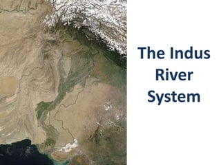
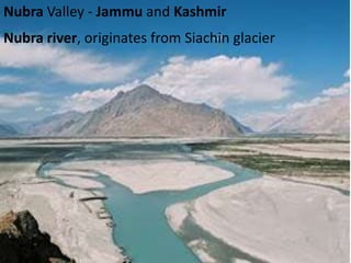
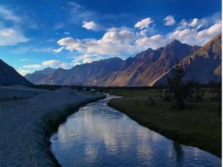
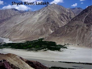
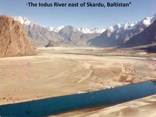
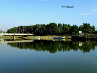
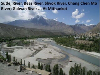
The document discusses several major rivers within the Indus River System located in India and Pakistan. It mentions the Indus River originates in Tibet near Lake Manasarowar and flows through India's Ladakh region before entering Pakistan. It also discusses tributaries like the Shyok River and Nubra River which feed into the Indus. Other key tributaries mentioned include the Jhelum, Chenab, Ravi, Beas, and Sutlej rivers.
The Indian sub-continent is characterised by a great and diversified group of physical features.
They are classified into the following physiographic units :
1. The Himalayas and other ranges.
2. The Indo-Gangetic plain.
3. The Thar Deserts
4. The Peninsular Plateau.
5. The Coastal belts and Islands.
this helps students of IX CBSE to visualise the picturesqueness the Ganga river system from its source to its delta and the role of each individual to preserve the holy river
PPT on India's Drainage System (River System) Rohan Karmakar
The following presentation is on India's drainage or river system. It includes information about some of the major river systems in India. All comments are welcomed. Please LIKE this presentation.
India is one of such country in the world which is bestowed with good number of rivers and tributaries, which are helpful not only in the field of agricultural but also in inland transport system of the country.Rivers also form the basis for domestic and industrial water supply, generation of hydro-electricity, inland fishing, are responsible for deposition of fertile soil in the plains as well as formation of deltas. This module explains the river systems of India.
The term river system refers to a ‘river along with its tributaries’.
Based on their source, the Indian River system is classified in to - Himalayan Rivers and Peninsular Rivers.
The Himalayan Rivers, as the name suggests originate from the Himalayas and flow through the Northern Plains.
The major Himalayan River systems are
The Indus River System,
The Ganga River System
The Yamuna River System
The Brahmaputra River System
Peninsular River System or Peninsular Drainage emerges mainly from the Western Ghats. Since the Western Ghats form a ‘water divide’, these rivers either flow eastwards into the Bay of Bengal or into the Arabian Sea towards the west. Peninsular Rivers are basically ‘rain fed’ rivers.
The major Peninsular River Systems are:
Mahanadi
Godavari
Krishna
Cauvery
Drain into Bay of Bengal as they flow eastwards on the plateau and make ‘deltas’ at their mouths; whereas Narmada
Tapti - the west flowing rivers fall into the Arabian Sea and make ‘estuaries’.
not originate in glaciers, but are rain fed rivers. These rivers reduce considerably or dry up during summers.
the presentation includes details about head works and barrages, how they operate, what are the differences between them and it includes a list of names of different barrages and head works in Pakistan.
India is a land of many rivers and mountains.
India’s geographical area of about 329 MHa is criss-crossed by a large number rivers. Some of the Indian rivers are figuring amongst the most notable rivers of the world. This module explain the river systems of India.
Hello friends, this is my new blog. And I am adding this post in the name of Top 10 Dams in India. I am working hard so please support me. Watch and like my posts
India is home to one of the world’s oldest civilizations—the Indus Valley Civilization. India is also home to many rivers of mythological and historical importance, which continue to serve the vast Indian population. With global environmental problems threatening to wreck havoc, India’s rivers too will fall victim unless we take measures to protect them. The power point presentation that follows provides a brief overview of some of India’s major rivers and India’s river based civilizations. The teacher can use this presentation to not only teach children about India’s rivers but also to get them to think of the problems facing some of our rivers—the pollution in the Ganges, for instance or the repercussions of the Sardar Sarovar Dam across the Narmada—and generate a discussion.
The Roman Empire A Historical Colossus.pdfkaushalkr1407
The Roman Empire, a vast and enduring power, stands as one of history's most remarkable civilizations, leaving an indelible imprint on the world. It emerged from the Roman Republic, transitioning into an imperial powerhouse under the leadership of Augustus Caesar in 27 BCE. This transformation marked the beginning of an era defined by unprecedented territorial expansion, architectural marvels, and profound cultural influence.
The empire's roots lie in the city of Rome, founded, according to legend, by Romulus in 753 BCE. Over centuries, Rome evolved from a small settlement to a formidable republic, characterized by a complex political system with elected officials and checks on power. However, internal strife, class conflicts, and military ambitions paved the way for the end of the Republic. Julius Caesar’s dictatorship and subsequent assassination in 44 BCE created a power vacuum, leading to a civil war. Octavian, later Augustus, emerged victorious, heralding the Roman Empire’s birth.
Under Augustus, the empire experienced the Pax Romana, a 200-year period of relative peace and stability. Augustus reformed the military, established efficient administrative systems, and initiated grand construction projects. The empire's borders expanded, encompassing territories from Britain to Egypt and from Spain to the Euphrates. Roman legions, renowned for their discipline and engineering prowess, secured and maintained these vast territories, building roads, fortifications, and cities that facilitated control and integration.
The Roman Empire’s society was hierarchical, with a rigid class system. At the top were the patricians, wealthy elites who held significant political power. Below them were the plebeians, free citizens with limited political influence, and the vast numbers of slaves who formed the backbone of the economy. The family unit was central, governed by the paterfamilias, the male head who held absolute authority.
Culturally, the Romans were eclectic, absorbing and adapting elements from the civilizations they encountered, particularly the Greeks. Roman art, literature, and philosophy reflected this synthesis, creating a rich cultural tapestry. Latin, the Roman language, became the lingua franca of the Western world, influencing numerous modern languages.
Roman architecture and engineering achievements were monumental. They perfected the arch, vault, and dome, constructing enduring structures like the Colosseum, Pantheon, and aqueducts. These engineering marvels not only showcased Roman ingenuity but also served practical purposes, from public entertainment to water supply.
Instructions for Submissions thorugh G- Classroom.pptxJheel Barad
This presentation provides a briefing on how to upload submissions and documents in Google Classroom. It was prepared as part of an orientation for new Sainik School in-service teacher trainees. As a training officer, my goal is to ensure that you are comfortable and proficient with this essential tool for managing assignments and fostering student engagement.
2024.06.01 Introducing a competency framework for languag learning materials ...Sandy Millin
http://sandymillin.wordpress.com/iateflwebinar2024
Published classroom materials form the basis of syllabuses, drive teacher professional development, and have a potentially huge influence on learners, teachers and education systems. All teachers also create their own materials, whether a few sentences on a blackboard, a highly-structured fully-realised online course, or anything in between. Despite this, the knowledge and skills needed to create effective language learning materials are rarely part of teacher training, and are mostly learnt by trial and error.
Knowledge and skills frameworks, generally called competency frameworks, for ELT teachers, trainers and managers have existed for a few years now. However, until I created one for my MA dissertation, there wasn’t one drawing together what we need to know and do to be able to effectively produce language learning materials.
This webinar will introduce you to my framework, highlighting the key competencies I identified from my research. It will also show how anybody involved in language teaching (any language, not just English!), teacher training, managing schools or developing language learning materials can benefit from using the framework.
How to Create Map Views in the Odoo 17 ERPCeline George
The map views are useful for providing a geographical representation of data. They allow users to visualize and analyze the data in a more intuitive manner.
How to Make a Field invisible in Odoo 17Celine George
It is possible to hide or invisible some fields in odoo. Commonly using “invisible” attribute in the field definition to invisible the fields. This slide will show how to make a field invisible in odoo 17.
How to Split Bills in the Odoo 17 POS ModuleCeline George
Bills have a main role in point of sale procedure. It will help to track sales, handling payments and giving receipts to customers. Bill splitting also has an important role in POS. For example, If some friends come together for dinner and if they want to divide the bill then it is possible by POS bill splitting. This slide will show how to split bills in odoo 17 POS.
Read| The latest issue of The Challenger is here! We are thrilled to announce that our school paper has qualified for the NATIONAL SCHOOLS PRESS CONFERENCE (NSPC) 2024. Thank you for your unwavering support and trust. Dive into the stories that made us stand out!
Palestine last event orientationfvgnh .pptxRaedMohamed3
An EFL lesson about the current events in Palestine. It is intended to be for intermediate students who wish to increase their listening skills through a short lesson in power point.
17. Nubra Valley is about 150 km north
of Leh, the capital town
of Ladakh, India. Local scholars say
that its original name was Ldumra(the
valley of flowers). The Shyok River
meets the Nubra or Siachan River to
form a large valley that separates the
Ladakh and the Karakoram Ranges.
22. Gateway to Nubra..
Nubra Valley is about 150 km north of Leh, the capital town of
Ladakh, India. This is where Shyok River meets the Nubra or
Siachan River to form a large valley that separates the Ladakh
and the Karakoram Ranges.
23. Both sides of the western Himalayas from Chitral in
Pakistan, eastward to Leh and the upper Shyok River
in Ladakh
39. Sutlej River, an
important tributary of
the Indus River is the
longest of the five
rivers. It flows through
Punjab in northern
India as well as
Pakistan. It originates
from the snow filled
Mansarovar Lake in
Tibet and ends in
Pakistani Punjab near
the port city of Karachi
42. Bhakra Nangal dam is the biggest dam in India till
2011 whose construction was completed in 1963. It is
a concrete dam built on Satluj River. It is situated near
the border area between Punjab and Hemachel
pardesh. It is 2nd largest in Asia and 2nd highest in
India as well. The length of dam is about 1,700 ft
while its height is 711 ft. Surface area of dam is
168.35 km2. 10 heavy turbines are adjusted to this
hydro-project which has an Installed capacity of 1,000
MV to generate electricity. Water storage capacity of
dam is 9340 million cubic meter. After Indra Sagar
dam it is second largest water reservoir in India.
43.
44.
45.
46. Bhakra-Nangal Project is a joint venture
ofPunjab, Himachal Pradesh and Haryana.
Under this project, two dams have been
constructed over the river Satluj. They are
the Bhakra Dam and the Nangal Dam. The
Bhakra-Nangal Project is an example of
water management on scientific lines on
the largest scale.
64. This picturesque river that emanates from the great
Himalayas flows out to Jammu & Kashmir before gushing
along to Pakistan where it gets yet another new name - the
Chenab.