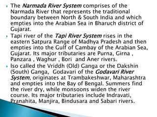
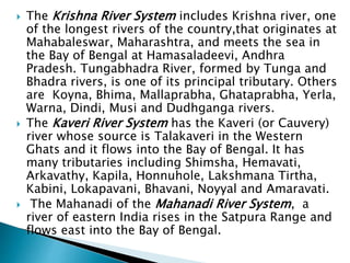
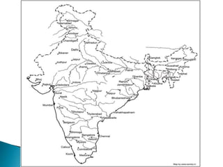
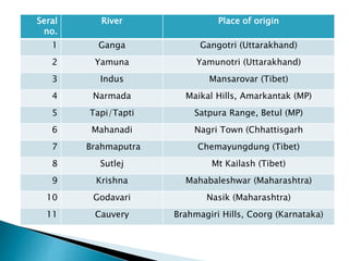
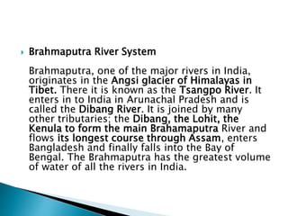
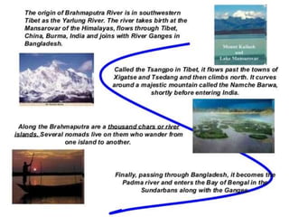
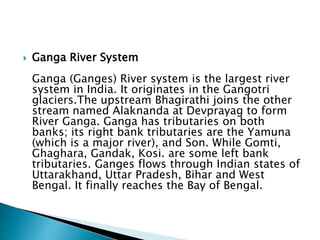
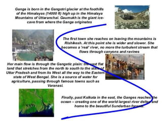
RIVERS OF INDIA:
Origin
&ClassificationNEHA AGARWAL
155066
B.SC. HONS
DEI , AGRA
 The common man sees its life granting blessed
form, the government or CWC engineer sees in it
as a potential dam project, the hydropower
developers a site for hydro project, a farmer his
crop vitality, fisher folk, boatspeople and river
bed cultivators a source of livelihood, the
industry & urban water utilities view it as their
personal waste basket, the real estate developer
as a potential land grab site, a sand miner as a
source of sand and the distraught villager his
lifeline.
 A river shifts in colour, shape, size, flow pattern of
water, silt, nutrients and biota, in fact all its variables
seem to change with time and space. The perceptions
differ as one moves from mountains to plains to the
deltas. The same stream displays a wide variance of
characteristics that depend upon the land it flows
through and the micro climate along its banks. Rivers
many a times seem to mirror the local flavour of the
land they flow through.
 Today, as we talk of rivers, their rejuvenation and try
to figure out their ecological flow and their health
quotient , a good beginning to understand the
existing rivers would be their classification modules.
What defines a river? Which factors are used for their
classification? How do we actually classify our rivers?
 As far as the first of these questions is concerned,
none of the official agencies have tried to define a
river!
Basin Map of
Rivers by
Central Water
Commission
NIH (National Institute of Hydrology) organises 7
major rivers
Indus, Brahmaputra, Narmada, Tapi, Godavari,
Krishna and Mahanadi
Most of the rivers pour their waters into the Bay of
Bengal. Some of the rivers whose courses take
them through the western part of the country and
towards the east of the state of Himachal Pradesh
empty into the Arabian Sea. Parts of Ladakh,
northern parts of the Aravalli range and the arid
parts of the Thar Desert have inland drainage. All
major rivers of India originate from one of the
three main watersheds.
 The Himalaya and the Karakoram ranges
 Vindhya and Satpura ranges and Chotanagpur
plateau in central India
 Sahyadri or Western Ghats in western India
Depending on the origin or where they begin
their journey from, there are
 Himalayan (perennial) rivers that rise from the
Himalayas
 he Peninsular rivers that originate from the
Indian plateau.
 The Himalayan rivers include the Ganga, the
Indus and the Brahmaputra river systems
along with their tributaries, which are fed
throughout the year by melting ice and
rainfall. They are swift, have great erosion
capacity and carry huge amounts of silt &
sand. They meander along the flat land,
create large fertile flood plains in their wake
and their banks are dotted by major towns
and cities.
 The peninsular rivers, on the other hand are
more or less dependent on rain. These are
gentler in their flow, follow a relatively
straighter path, have comparatively
less gradient and include Narmada, Tapi,
Godavari, Krishna, Cauveri and Mahanadi
rivers, among many others.
 The Himalayan Rivers flow throughout the year, are prone to
flooding and include Indus and the Ganga-Brahmaputra-
Meghna.
 The Deccan Rivers include the Narmada and Tapi rivers that flow
westwards into the Arabian Sea, and the Brahmani, Mahanadi,
Godavari, Krishna, Pennar & Cauvery that fall into the Bay of
Bengal.
 The Coastal Rivers are comparatively small in size and numerous
in number, with nearly 600 flowing on the west coast itself.
 Rivers of the Inland Drainage Basin are centered in western
Rajasthan, parts of Kutch in Gujarat and mostly disappear before
they reach the sea as the rainfall here is scarce. Some of them
drain into salt lakes or simply get lost in the vast desert sands.
 Island Rivers Rivers of our islands: A&N islands & Lakshadweep
group of islands
 On the basis of the basin formed, our rivers are
distributed into 7 river system
 The Indus River System originates in Kailash
range in Tibet, and includes Zanskar, Shyok,
Nubra ,Hunza (in Kashmir) along with Jhelum,
Chenab, Ravi, Beas and Sutlej as its principal
tributaries.
 the Brahmaputra River System, it was earlier
assumed that the Mansarovar lake is the source
of the Brahmaputra river, however, now it is
confirmed that Angsi Glacier is the main
source .Most of the course of the river lies
outside the country. In India it flows through
Arunachal Pradesh and Assam, where it is joined
by several tributaries.
 The Narmada River System comprises of the
Narmada River that represents the traditional
boundary between North & South India and which
empties into the Arabian Sea in Bharuch district of
Gujarat.
 Tapi river of the Tapi River System rises in the
eastern Satpura Range of Madhya Pradesh and then
empties into the Gulf of Cambay of the Arabian Sea,
Gujarat. Its major tributaries are Purna, Girna ,
Panzara , Waghur , Bori and Aner rivers.
 lso called the Vriddh (Old) Ganga or the Dakshin
(South) Ganga, Godavari of the Godavari River
System, originates at Trambakeshwar, Maharashtra
and empties into the Bay of Bengal. Summers find
the river dry, while monsoons widen the river
course. Its major tributaries include Indravati,
Pranahita, Manjira, Bindusara and Sabari rivers.
 The Krishna River System includes Krishna river, one
of the longest rivers of the country,that originates at
Mahabaleswar, Maharashtra, and meets the sea in
the Bay of Bengal at Hamasaladeevi, Andhra
Pradesh. Tungabhadra River, formed by Tunga and
Bhadra rivers, is one of its principal tributary. Others
are Koyna, Bhima, Mallaprabha, Ghataprabha, Yerla,
Warna, Dindi, Musi and Dudhganga rivers.
 The Kaveri River System has the Kaveri (or Cauvery)
river whose source is Talakaveri in the Western
Ghats and it flows into the Bay of Bengal. It has
many tributaries including Shimsha, Hemavati,
Arkavathy, Kapila, Honnuhole, Lakshmana Tirtha,
Kabini, Lokapavani, Bhavani, Noyyal and Amaravati.
 The Mahanadi of the Mahanadi River System, a
river of eastern India rises in the Satpura Range and
flows east into the Bay of Bengal.
Seral
no.
River Place of origin
1 Ganga Gangotri (Uttarakhand)
2 Yamuna Yamunotri (Uttarakhand)
3 Indus Mansarovar (Tibet)
4 Narmada Maikal Hills, Amarkantak (MP)
5 Tapi/Tapti Satpura Range, Betul (MP)
6 Mahanadi Nagri Town (Chhattisgarh
7 Brahmaputra Chemayungdung (Tibet)
8 Sutlej Mt Kailash (Tibet)
9 Krishna Mahabaleshwar (Maharashtra)
10 Godavari Nasik (Maharashtra)
11 Cauvery Brahmagiri Hills, Coorg (Karnataka)
 Brahmaputra River System
Brahmaputra, one of the major rivers in India,
originates in the Angsi glacier of Himalayas in
Tibet. There it is known as the Tsangpo River. It
enters in to India in Arunachal Pradesh and is
called the Dibang River. It is joined by many
other tributaries; the Dibang, the Lohit, the
Kenula to form the main Brahamaputra River and
flows its longest course through Assam, enters
Bangladesh and finally falls into the Bay of
Bengal. The Brahmaputra has the greatest volume
of water of all the rivers in India.
 Ganga River System
Ganga (Ganges) River system is the largest river
system in India. It originates in the Gangotri
glaciers.The upstream Bhagirathi joins the other
stream named Alaknanda at Devprayag to form
River Ganga. Ganga has tributaries on both
banks; its right bank tributaries are the Yamuna
(which is a major river), and Son. While Gomti,
Ghaghara, Gandak, Kosi. are some left bank
tributaries. Ganges flows through Indian states of
Uttarakhand, Uttar Pradesh, Bihar and West
Bengal. It finally reaches the Bay of Bengal.
 Indus River System
The reference of Indus River or Sindhu River is found
in the early Hindu Scriptures and mythological texts..
It is known as ‘Puranik River’. The river originates in
Tibet near Mansarovar Lake. Flowing westwards, it
enters India in Jammu and Kashmir, further flows
through Himachal Pradesh, Punjab and enters
Pakistan. Flowing further westwards, it reaches the
Arabian Sea near Karachi. Indus is the largest river in
Pakistan and is the country's national river. Its
tributaries in India are Zanskar, Nubra and Shyok, and
Hunza in Pakistan. Sutlej, Ravi, Beas, Chenab and
Jhelum are its other tributaries after which the state
of Punjab is named.
 Mahanadi
The Mahanadi is a major river in East-central
India. It originates in the Sihava mountains of
Chhattisgarhandflows its major course
through the state of Orissa (Odisha). This
river deposits more silt than any other river in
the Indian subcontinent. Mahanadi flows
through cities Sambalpur, Cuttack and Banki.
 Godavari
The Godavari River covers the second longest
course in India after the Ganga. The river
originates at Triambakeshwar in Maharashtra,
and together with its tributaries (Pravara,
Indravati, Maner Sabri etc,) flows through the
states of Maharashtra, Chhattisgarh, Madhya
Pradesh, Orissa (Odisha), Telangana, Andhra
Pradesh, Karnataka and Puducherry, to finally
flow in to the Bay of Bengal. Thanks to its long
course, the river is described as Dakshina Ganga.
 Krishna River
The Krishna is the third longest river in India
with a length of about 1300 kms. Originating
from Maharashtra's Mahabaleshwar region it
flows through Karnataka, Telangana, and
Andhra Pradesh to finally pour into the Bay of
Bengal.
 Kaveri River
The Kaveri (Cauvery) is a major river in Southern
India and originates in Kogadu, Karnataka.in the
form of a spring at Brahmagiri Hill at
Talakaveri, Also known as th Ganges of the
South, it is one of the holiest rivers in South
India. Kaveri River widens as many tributaries
such as Hemavati, Moyari, Shimsha, Arkavati,
Honnuhole, Kabini, Bhavani, Noyill and Amaravati
join it. The slithers about 800 kilometers across
the three states, Karnataka, Kerala and
Tamilnadu, slightly touching Pudducherry and
drains in to the Bay of Bengal.
 Yamuna River System
The Yamuna is a major river system in
Northern India. The river rises from Yamnotri
and flows through Uttrakhand, Uttar Pradesh
and Haryana. It passes through Delhi,
Mathura, Agra and meets the rivers Chambal,
Betwa and Ken to finally join the Ganga at
Allahabad.. Major tributaries of Yamuna are
Tons, Chambal, Hindon, Betwa and Ken.
Indian rivers
Indian rivers

Indian rivers

  • 1.
    RIVERS OF INDIA: Origin &ClassificationNEHAAGARWAL 155066 B.SC. HONS DEI , AGRA
  • 2.
     The commonman sees its life granting blessed form, the government or CWC engineer sees in it as a potential dam project, the hydropower developers a site for hydro project, a farmer his crop vitality, fisher folk, boatspeople and river bed cultivators a source of livelihood, the industry & urban water utilities view it as their personal waste basket, the real estate developer as a potential land grab site, a sand miner as a source of sand and the distraught villager his lifeline.
  • 3.
     A rivershifts in colour, shape, size, flow pattern of water, silt, nutrients and biota, in fact all its variables seem to change with time and space. The perceptions differ as one moves from mountains to plains to the deltas. The same stream displays a wide variance of characteristics that depend upon the land it flows through and the micro climate along its banks. Rivers many a times seem to mirror the local flavour of the land they flow through.  Today, as we talk of rivers, their rejuvenation and try to figure out their ecological flow and their health quotient , a good beginning to understand the existing rivers would be their classification modules. What defines a river? Which factors are used for their classification? How do we actually classify our rivers?  As far as the first of these questions is concerned, none of the official agencies have tried to define a river!
  • 4.
    Basin Map of Riversby Central Water Commission
  • 5.
    NIH (National Instituteof Hydrology) organises 7 major rivers Indus, Brahmaputra, Narmada, Tapi, Godavari, Krishna and Mahanadi Most of the rivers pour their waters into the Bay of Bengal. Some of the rivers whose courses take them through the western part of the country and towards the east of the state of Himachal Pradesh empty into the Arabian Sea. Parts of Ladakh, northern parts of the Aravalli range and the arid parts of the Thar Desert have inland drainage. All major rivers of India originate from one of the three main watersheds.  The Himalaya and the Karakoram ranges  Vindhya and Satpura ranges and Chotanagpur plateau in central India  Sahyadri or Western Ghats in western India
  • 7.
    Depending on theorigin or where they begin their journey from, there are  Himalayan (perennial) rivers that rise from the Himalayas  he Peninsular rivers that originate from the Indian plateau.
  • 8.
     The Himalayanrivers include the Ganga, the Indus and the Brahmaputra river systems along with their tributaries, which are fed throughout the year by melting ice and rainfall. They are swift, have great erosion capacity and carry huge amounts of silt & sand. They meander along the flat land, create large fertile flood plains in their wake and their banks are dotted by major towns and cities.
  • 9.
     The peninsularrivers, on the other hand are more or less dependent on rain. These are gentler in their flow, follow a relatively straighter path, have comparatively less gradient and include Narmada, Tapi, Godavari, Krishna, Cauveri and Mahanadi rivers, among many others.
  • 10.
     The HimalayanRivers flow throughout the year, are prone to flooding and include Indus and the Ganga-Brahmaputra- Meghna.  The Deccan Rivers include the Narmada and Tapi rivers that flow westwards into the Arabian Sea, and the Brahmani, Mahanadi, Godavari, Krishna, Pennar & Cauvery that fall into the Bay of Bengal.  The Coastal Rivers are comparatively small in size and numerous in number, with nearly 600 flowing on the west coast itself.  Rivers of the Inland Drainage Basin are centered in western Rajasthan, parts of Kutch in Gujarat and mostly disappear before they reach the sea as the rainfall here is scarce. Some of them drain into salt lakes or simply get lost in the vast desert sands.  Island Rivers Rivers of our islands: A&N islands & Lakshadweep group of islands
  • 11.
     On thebasis of the basin formed, our rivers are distributed into 7 river system  The Indus River System originates in Kailash range in Tibet, and includes Zanskar, Shyok, Nubra ,Hunza (in Kashmir) along with Jhelum, Chenab, Ravi, Beas and Sutlej as its principal tributaries.  the Brahmaputra River System, it was earlier assumed that the Mansarovar lake is the source of the Brahmaputra river, however, now it is confirmed that Angsi Glacier is the main source .Most of the course of the river lies outside the country. In India it flows through Arunachal Pradesh and Assam, where it is joined by several tributaries.
  • 12.
     The NarmadaRiver System comprises of the Narmada River that represents the traditional boundary between North & South India and which empties into the Arabian Sea in Bharuch district of Gujarat.  Tapi river of the Tapi River System rises in the eastern Satpura Range of Madhya Pradesh and then empties into the Gulf of Cambay of the Arabian Sea, Gujarat. Its major tributaries are Purna, Girna , Panzara , Waghur , Bori and Aner rivers.  lso called the Vriddh (Old) Ganga or the Dakshin (South) Ganga, Godavari of the Godavari River System, originates at Trambakeshwar, Maharashtra and empties into the Bay of Bengal. Summers find the river dry, while monsoons widen the river course. Its major tributaries include Indravati, Pranahita, Manjira, Bindusara and Sabari rivers.
  • 13.
     The KrishnaRiver System includes Krishna river, one of the longest rivers of the country,that originates at Mahabaleswar, Maharashtra, and meets the sea in the Bay of Bengal at Hamasaladeevi, Andhra Pradesh. Tungabhadra River, formed by Tunga and Bhadra rivers, is one of its principal tributary. Others are Koyna, Bhima, Mallaprabha, Ghataprabha, Yerla, Warna, Dindi, Musi and Dudhganga rivers.  The Kaveri River System has the Kaveri (or Cauvery) river whose source is Talakaveri in the Western Ghats and it flows into the Bay of Bengal. It has many tributaries including Shimsha, Hemavati, Arkavathy, Kapila, Honnuhole, Lakshmana Tirtha, Kabini, Lokapavani, Bhavani, Noyyal and Amaravati.  The Mahanadi of the Mahanadi River System, a river of eastern India rises in the Satpura Range and flows east into the Bay of Bengal.
  • 16.
    Seral no. River Place oforigin 1 Ganga Gangotri (Uttarakhand) 2 Yamuna Yamunotri (Uttarakhand) 3 Indus Mansarovar (Tibet) 4 Narmada Maikal Hills, Amarkantak (MP) 5 Tapi/Tapti Satpura Range, Betul (MP) 6 Mahanadi Nagri Town (Chhattisgarh 7 Brahmaputra Chemayungdung (Tibet) 8 Sutlej Mt Kailash (Tibet) 9 Krishna Mahabaleshwar (Maharashtra) 10 Godavari Nasik (Maharashtra) 11 Cauvery Brahmagiri Hills, Coorg (Karnataka)
  • 17.
     Brahmaputra RiverSystem Brahmaputra, one of the major rivers in India, originates in the Angsi glacier of Himalayas in Tibet. There it is known as the Tsangpo River. It enters in to India in Arunachal Pradesh and is called the Dibang River. It is joined by many other tributaries; the Dibang, the Lohit, the Kenula to form the main Brahamaputra River and flows its longest course through Assam, enters Bangladesh and finally falls into the Bay of Bengal. The Brahmaputra has the greatest volume of water of all the rivers in India.
  • 19.
     Ganga RiverSystem Ganga (Ganges) River system is the largest river system in India. It originates in the Gangotri glaciers.The upstream Bhagirathi joins the other stream named Alaknanda at Devprayag to form River Ganga. Ganga has tributaries on both banks; its right bank tributaries are the Yamuna (which is a major river), and Son. While Gomti, Ghaghara, Gandak, Kosi. are some left bank tributaries. Ganges flows through Indian states of Uttarakhand, Uttar Pradesh, Bihar and West Bengal. It finally reaches the Bay of Bengal.
  • 21.
     Indus RiverSystem The reference of Indus River or Sindhu River is found in the early Hindu Scriptures and mythological texts.. It is known as ‘Puranik River’. The river originates in Tibet near Mansarovar Lake. Flowing westwards, it enters India in Jammu and Kashmir, further flows through Himachal Pradesh, Punjab and enters Pakistan. Flowing further westwards, it reaches the Arabian Sea near Karachi. Indus is the largest river in Pakistan and is the country's national river. Its tributaries in India are Zanskar, Nubra and Shyok, and Hunza in Pakistan. Sutlej, Ravi, Beas, Chenab and Jhelum are its other tributaries after which the state of Punjab is named.
  • 22.
     Mahanadi The Mahanadiis a major river in East-central India. It originates in the Sihava mountains of Chhattisgarhandflows its major course through the state of Orissa (Odisha). This river deposits more silt than any other river in the Indian subcontinent. Mahanadi flows through cities Sambalpur, Cuttack and Banki.
  • 23.
     Godavari The GodavariRiver covers the second longest course in India after the Ganga. The river originates at Triambakeshwar in Maharashtra, and together with its tributaries (Pravara, Indravati, Maner Sabri etc,) flows through the states of Maharashtra, Chhattisgarh, Madhya Pradesh, Orissa (Odisha), Telangana, Andhra Pradesh, Karnataka and Puducherry, to finally flow in to the Bay of Bengal. Thanks to its long course, the river is described as Dakshina Ganga.
  • 24.
     Krishna River TheKrishna is the third longest river in India with a length of about 1300 kms. Originating from Maharashtra's Mahabaleshwar region it flows through Karnataka, Telangana, and Andhra Pradesh to finally pour into the Bay of Bengal.
  • 25.
     Kaveri River TheKaveri (Cauvery) is a major river in Southern India and originates in Kogadu, Karnataka.in the form of a spring at Brahmagiri Hill at Talakaveri, Also known as th Ganges of the South, it is one of the holiest rivers in South India. Kaveri River widens as many tributaries such as Hemavati, Moyari, Shimsha, Arkavati, Honnuhole, Kabini, Bhavani, Noyill and Amaravati join it. The slithers about 800 kilometers across the three states, Karnataka, Kerala and Tamilnadu, slightly touching Pudducherry and drains in to the Bay of Bengal.
  • 26.
     Yamuna RiverSystem The Yamuna is a major river system in Northern India. The river rises from Yamnotri and flows through Uttrakhand, Uttar Pradesh and Haryana. It passes through Delhi, Mathura, Agra and meets the rivers Chambal, Betwa and Ken to finally join the Ganga at Allahabad.. Major tributaries of Yamuna are Tons, Chambal, Hindon, Betwa and Ken.