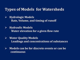
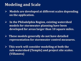
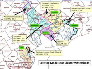
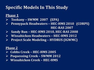
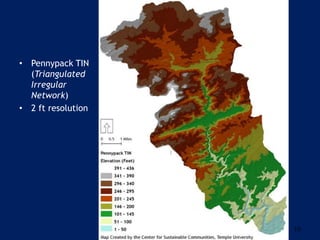
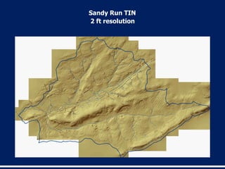
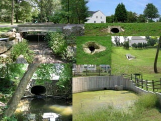
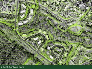
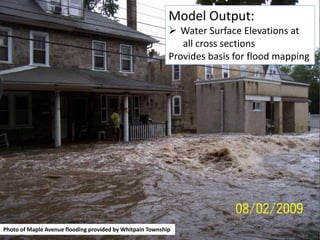
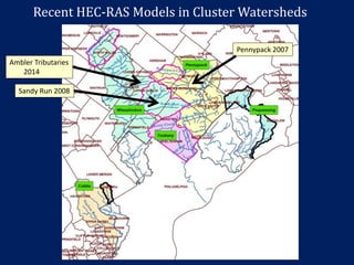
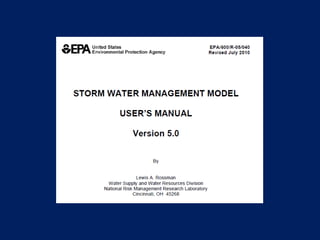
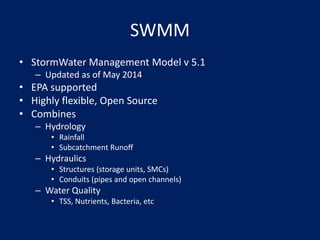
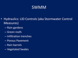
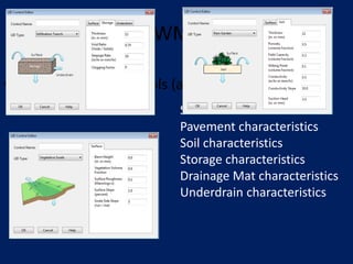
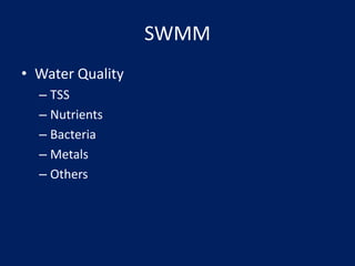
Upstream Suburban Philadelphia Sub-watershed Cluster
Modeling Overview
October 21, 2014
Robert J. Ryan, PhD., P.E.
CEE Department
Temple University
Jeffrey Featherstone, PhD.
Center for Sustainable Communities
Temple University
Richard K. Fromuth, P.E.
Center for Sustainable Communities
Temple University
Presentation Format
 Modeling Basics
 Role of the modeling work
 Specific Models for this study
*HEC (Corps)
*SWMM (EPA)
 Questions
Modeling Basics
 Models are used to represent a process or
operation with equations and data.
 They allow for experiments and comparisons
to predict outcomes.
 They can inform decision making and reduce
costs.
 Models are used in stormwater management and
water quality analysis.
Role of the Modeling Work
 Modeling is a component of the Implementation
Plan for the Upstream Suburban Philadelphia
Sub-Watershed Cluster.
 Phase 1 of this work has been funded by the
William Penn Foundation and includes modeling
for the Tookany, Pennypack Headwaters, Wissahickon
Headwaters, and Sandy Run sub-watersheds.
 Modeling is a means to evaluate the effectiveness
of stormwater control measures individually and
collectively for sub-watersheds.
Types of Models for Watersheds
 Hydrologic Models
Rate, Volume, and timing of runoff
 Hydraulic Models
Water elevation for a given flow rate
 Water Quality Models
Loadings and concentrations of substances
 Models can be for discrete events or can be
continuous
Modeling and Scale
 Models are developed at different scales depending
on the application.
 In the Philadelphia Region, existing watershed
models for stormwater planning have been
developed for areas larger than 10 square miles.
 These models generally do not have detailed
representation for stormwater control measures.
 This work will consider modeling at both the
sub-watershed (Temple) and project site scales.
(Villanova)
Wissahickon Headwaters
HEC-HMS 2012
Pennypack Headwaters
HEC-HMS 2010
HEC-RAS 2007
Sandy Run
HEC-HMS 2012
HEC-RAS 2008
Poquessing Creek- Phase 2
SWMM 2012
East Branch Indian Creek- Phase 2
HEC-HMS 2005
Tookany
SWMM 2007
Existing Models for Cluster Watersheds
Specific Models In This Study
Phase 1
 Tookany – SWMM 2007 (EPA)
 Pennypack Headwaters – HEC-HMS 2010 (CORPS)
HEC-RAS 2007
 Sandy Run – HEC-HMS 2010, HEC-RAS 2008
 Wissahickon Headwaters – HEC-HMS 2012
 Project Scale Modeling – HYDRUS (IGWMC)
Phase 2
 Cobbs Creek – HEC-HMS 2005
 Poquessing Creek – SWMM 2012
 Wissahickon Creek – HEC-HMS
Modeling activities in study contract with
William Penn Foundation
 Enhance LIDAR Terrain Data for the Tookany and
Wissahickon Headwaters
 Begin development of a HEC-RAS model for the
Wissahickon Headwaters
 Collect detention basin data and refine model
representation for each sub-watershed scale model with
more detailed data for detention basins with 1 or more
acre-ft of storage.
 Perform an obstruction survey for the Tookany watershed
and improve hydraulic modeling.
 Refine sub-watershed model capabilities using monitoring
results and results of Villanova’s project scale modeling.
10
• Pennypack TIN
(Triangulated
Irregular
Network)
• 2 ft resolution
2 ft resolution
Sandy Run TIN
HEC –HMS
Hydrologic Model
Flow Rates
Runoff Volume
Timing
Developed by US Army
Corps of Engineers
HEC :
Hydrologic Engineering
Center
Latest Version
December 2013
http://www.hec.usace.army.mil/software/hec-hms/features.aspx
HEC - RAS
Hydaulic Model
Water Elevations
Developed by US Army
Corps of Engineers
HEC :
Hydrologic Engineering
Center
Latest Version
January 2010
Data Requirements:
 Obstruction Dimensions
 Obstruction Elevations
 Photographs with Scale
 Terrain Data
 Cross Section Geometry
 Ortho
 Roughness Coefficients
 Flow Rates
http://www.hec.usace.army.mil/software/hec-ras/documentation.aspx
16
New Ortho-Photo
17
2 Feet Contour Data
Photo of Maple Avenue flooding provided by Whitpain Township
Model Output:
 Water Surface Elevations at
all cross sections
Provides basis for flood mapping
Recent HEC-RAS Models in Cluster Watersheds
Sandy Run 2008
Pennypack 2007
Ambler Tributaries
2014
SWMM
• StormWater Management Model v 5.1
– Updated as of May 2014
• EPA supported
• Highly flexible, Open Source
• Combines
– Hydrology
• Rainfall
• Subcatchment Runoff
– Hydraulics
• Structures (storage units, SMCs)
• Conduits (pipes and open channels)
– Water Quality
• TSS, Nutrients, Bacteria, etc
SWMM
• Hydraulics: LID Controls (aka Stormwater Control
Measures)
– Rain gardens
– Green roofs
– Infiltration trenches
– Porous Pavement
– Rain barrels
– Vegetated Swales
SWMM
• Hydraulics: LID Controls (aka Stormwater Control
Measures)
– Rain gardens
– Green roofs
– Infiltration trenches
– Porous Pavement
– Rain barrels
– Vegetated Swales
Surface characteristics
Pavement characteristics
Soil characteristics
Storage characteristics
Drainage Mat characteristics
Underdrain characteristics
SWMM
• Water Quality
– TSS
– Nutrients
– Bacteria
– Metals
– Others
SWMM
• CONCLUSION
– SWMM can model
• Rainfall
• Subcatchment Runoff
• Channel and Pipe Flow
• LID Control/SCM performance
• Water Quality
CONTACTS
Center for Sustainable Communities
Temple University Ambler
580 Meetinghouse Rd, Ambler, PA 19002
http://www.csc.temple.edu
E-mail: jeffrey.featherstone@temple.edu
rjryan@temple.edu
richard.fromuth@temple.edu

Upstream Suburban Philadelphia Sub-Watershed Cluster Modeling Overview

  • 1.
    Upstream Suburban PhiladelphiaSub-watershed Cluster Modeling Overview October 21, 2014 Robert J. Ryan, PhD., P.E. CEE Department Temple University Jeffrey Featherstone, PhD. Center for Sustainable Communities Temple University Richard K. Fromuth, P.E. Center for Sustainable Communities Temple University
  • 2.
    Presentation Format  ModelingBasics  Role of the modeling work  Specific Models for this study *HEC (Corps) *SWMM (EPA)  Questions
  • 3.
    Modeling Basics  Modelsare used to represent a process or operation with equations and data.  They allow for experiments and comparisons to predict outcomes.  They can inform decision making and reduce costs.  Models are used in stormwater management and water quality analysis.
  • 4.
    Role of theModeling Work  Modeling is a component of the Implementation Plan for the Upstream Suburban Philadelphia Sub-Watershed Cluster.  Phase 1 of this work has been funded by the William Penn Foundation and includes modeling for the Tookany, Pennypack Headwaters, Wissahickon Headwaters, and Sandy Run sub-watersheds.  Modeling is a means to evaluate the effectiveness of stormwater control measures individually and collectively for sub-watersheds.
  • 5.
    Types of Modelsfor Watersheds  Hydrologic Models Rate, Volume, and timing of runoff  Hydraulic Models Water elevation for a given flow rate  Water Quality Models Loadings and concentrations of substances  Models can be for discrete events or can be continuous
  • 6.
    Modeling and Scale Models are developed at different scales depending on the application.  In the Philadelphia Region, existing watershed models for stormwater planning have been developed for areas larger than 10 square miles.  These models generally do not have detailed representation for stormwater control measures.  This work will consider modeling at both the sub-watershed (Temple) and project site scales. (Villanova)
  • 7.
    Wissahickon Headwaters HEC-HMS 2012 PennypackHeadwaters HEC-HMS 2010 HEC-RAS 2007 Sandy Run HEC-HMS 2012 HEC-RAS 2008 Poquessing Creek- Phase 2 SWMM 2012 East Branch Indian Creek- Phase 2 HEC-HMS 2005 Tookany SWMM 2007 Existing Models for Cluster Watersheds
  • 8.
    Specific Models InThis Study Phase 1  Tookany – SWMM 2007 (EPA)  Pennypack Headwaters – HEC-HMS 2010 (CORPS) HEC-RAS 2007  Sandy Run – HEC-HMS 2010, HEC-RAS 2008  Wissahickon Headwaters – HEC-HMS 2012  Project Scale Modeling – HYDRUS (IGWMC) Phase 2  Cobbs Creek – HEC-HMS 2005  Poquessing Creek – SWMM 2012  Wissahickon Creek – HEC-HMS
  • 9.
    Modeling activities instudy contract with William Penn Foundation  Enhance LIDAR Terrain Data for the Tookany and Wissahickon Headwaters  Begin development of a HEC-RAS model for the Wissahickon Headwaters  Collect detention basin data and refine model representation for each sub-watershed scale model with more detailed data for detention basins with 1 or more acre-ft of storage.  Perform an obstruction survey for the Tookany watershed and improve hydraulic modeling.  Refine sub-watershed model capabilities using monitoring results and results of Villanova’s project scale modeling.
  • 10.
  • 11.
  • 13.
    HEC –HMS Hydrologic Model FlowRates Runoff Volume Timing Developed by US Army Corps of Engineers HEC : Hydrologic Engineering Center Latest Version December 2013 http://www.hec.usace.army.mil/software/hec-hms/features.aspx
  • 14.
    HEC - RAS HydaulicModel Water Elevations Developed by US Army Corps of Engineers HEC : Hydrologic Engineering Center Latest Version January 2010
  • 15.
    Data Requirements:  ObstructionDimensions  Obstruction Elevations  Photographs with Scale  Terrain Data  Cross Section Geometry  Ortho  Roughness Coefficients  Flow Rates http://www.hec.usace.army.mil/software/hec-ras/documentation.aspx
  • 16.
  • 17.
  • 18.
    Photo of MapleAvenue flooding provided by Whitpain Township Model Output:  Water Surface Elevations at all cross sections Provides basis for flood mapping
  • 19.
    Recent HEC-RAS Modelsin Cluster Watersheds Sandy Run 2008 Pennypack 2007 Ambler Tributaries 2014
  • 21.
    SWMM • StormWater ManagementModel v 5.1 – Updated as of May 2014 • EPA supported • Highly flexible, Open Source • Combines – Hydrology • Rainfall • Subcatchment Runoff – Hydraulics • Structures (storage units, SMCs) • Conduits (pipes and open channels) – Water Quality • TSS, Nutrients, Bacteria, etc
  • 22.
    SWMM • Hydraulics: LIDControls (aka Stormwater Control Measures) – Rain gardens – Green roofs – Infiltration trenches – Porous Pavement – Rain barrels – Vegetated Swales
  • 23.
    SWMM • Hydraulics: LIDControls (aka Stormwater Control Measures) – Rain gardens – Green roofs – Infiltration trenches – Porous Pavement – Rain barrels – Vegetated Swales Surface characteristics Pavement characteristics Soil characteristics Storage characteristics Drainage Mat characteristics Underdrain characteristics
  • 24.
    SWMM • Water Quality –TSS – Nutrients – Bacteria – Metals – Others
  • 25.
    SWMM • CONCLUSION – SWMMcan model • Rainfall • Subcatchment Runoff • Channel and Pipe Flow • LID Control/SCM performance • Water Quality
  • 26.
    CONTACTS Center for SustainableCommunities Temple University Ambler 580 Meetinghouse Rd, Ambler, PA 19002 http://www.csc.temple.edu E-mail: jeffrey.featherstone@temple.edu rjryan@temple.edu richard.fromuth@temple.edu