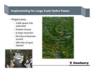
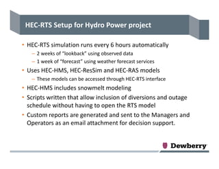
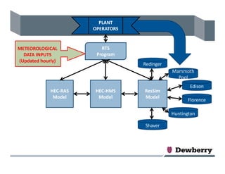
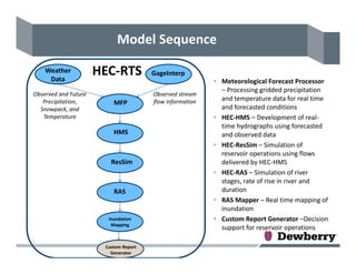
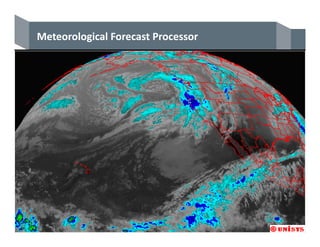
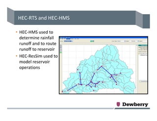
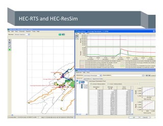
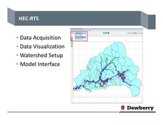
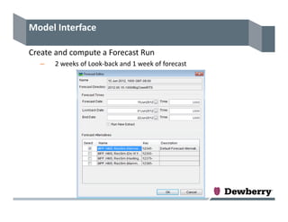
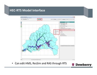
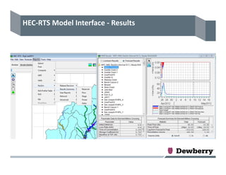
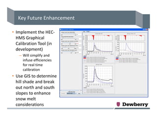
This document summarizes the implementation of a Real Time Simulation (RTS) model using HEC software for a large hydroelectric power project. Key aspects include:
1) The RTS model integrates HEC-HMS, HEC-ResSim, and HEC-RAS models to simulate rainfall-runoff, reservoir operations, and river stages in real-time using meteorological forecasts.
2) The project area includes a 1,640 square mile watershed with 9 power houses, 6 reservoirs, tunnels, and open channels modeled.
3) The RTS model runs automatically every 6 hours using 2 weeks of observed data and 1 week of forecasts to generate custom reports for reservoir operations decisions.
I have used Oracle Primavera Project Management P6 to built my resume. I did the experience and it looks pretty well to me. Comments are welcome to further improve.
Flood Risk Analysis for River Serio, Italy by using HECRAS & River 2DArshia Mousavi
Â
In this study, we modeled River Serio (Italy) for the assessment of Flood Risk using different modelling software. River Serio is an Italian river that flows across Lombardy region, crossing the provinces of Bergamo and Cremona. It is 125 Kms long and flows into Adda at Bocca di Serio south of Crema. Using software like HEC-RAS and River 2D to model the river section at ordinary and peak flows to analyse the possibilities of Flood. Using Analytical Calculations assessed Sediments carried away from Upstream to Downstream. By this analysis able to figure our the area going to be flooded and also the transport capacity of the sediments and the amount of sediments that can be carried by the flood water. Evaluated the Results and obtained some of the precautionary measures to protect the area from Flood. Analysis were made for one dimensional model for ordinary and peak discharge on steady model and Unsteady flow using 200 years hydro-graph. Also two dimensional analysis was made for steady flow at peak discharge. The results of both the models are compared to analyse the situation of the water profile and made related observations. Finally we calculated the sediments that gets transported in the river serio & the discharge by which the sediments gets transported. Looking at the entire scenario of different models and performing sensitive analysis to understand the pattern of the flood that can take place at different intensity levels.
Software Used: HEC-RAS for 1 Dimensional Modelling, River-2D for 2 Dimensional Modelling.
I gave this talk at a stormwater conference to help people think through some of the reasons for modelling, and how to get the most from their modelling efforts.
DSD-INT 2018 River Temperature Modeling, USA - BoyingtonDeltares
Â
Presentation by Matt Boyington, Tennessee Valley Authority (TVA), USA, at the Delft3D - User Days (Day 2: Hydrodynamics), during Delft Software Days - Edition 2018. Tuesday, 13 November 2018, Delft.
DSD-INT 2020 Real Time Hydrologic, Hydraulic and Water Quality Forecasting in...Deltares
Â
Presentation by Tony McAlister, WaterTech, at the Delft3D User Days - Australian Time zone: Inland to Estuary, during Delft Software Days - Edition 2020. Tuesday, 10 November 2020.
DSD-INT 2019 Delft FEWS-based flood forecasting system for Czech Hydrometeoro...Deltares
Â
Presentation by Stanislav VanÄÄek, Pavel TachecĂ, DHI CZ, at the Delft-FEWS User Days, during Delft Software Days - Edition 2019. Thursday, 7 November 2019, Delft.
Upstream Suburban Philadelphia Sub-Watershed Cluster Modeling OverviewKim Beidler
Â
Upstream Suburban Philadelphia Sub-Watershed Cluster Modeling Overview by Jeffrey Featherstone, Ph.D., Director, Center for Sustainable Communities, Temple University
DSD-NL 2021 WaterCoach, here and in Australia - WangDeltares
Â
Presentatie door Steve Wang (Seqwater), op de Delft-FEWS NL Gebruikersdag 2021 - deel 2, tijdens de Deltares Software Dagen - Editie 2021. Dinsdag, 22 juni 2021, Delft.
Esri UC 2017 Water Meeting - How Central San Became a GIS-Centric Water Resou...Carl Von Stetten
Â
In 2016 Central San completed the migration of its GIS operations to the ArcGIS platform to provide a foundation for a GIS-Centric operation. Central San leveraged the Local Government Information Model (LGIM) and associated maps, applications, and tools to improve the quality and efficiency of maintaining sewer, recycled water, and parcel-related GIS data. The completed GIS system became the authoritative data source for several other mission-critical applications: an intranet GIS portal, a Computerized Maintenance Management System, a CCTV pipeline inspection system, a hydraulic model, and a capital improvement planning system.
This presentation shows the main software used for numerically simulate the flood movement. first, it presents the HEC-RAS, then it discusses the Surface-water Modeling System (SMS), its interface, main components, DATA REQUIREMENTS and main steps to build a model using SMS.
Hec ras flood modeling little river newburyportWilliam Mullen
Â
This narrated PowerPoint presentation describes a HEC-RAS 2-D unsteady-flow flood model set up for the tidally-influenced Little River in Newburyport and Newbury, Massachusetts. It describes the steps in developing inputs to the HEC-RAS model including using HEC-HMS rainfall-runoff modeling and GIS in developing inputs to HEC-HMS. The HEC-RAS model was calibrated using the Mother's Day flood of May 2006. The HEC-RAS model may be used to evaluate impacts associated with proposed changes in culvert sizes or changing embankment elevations near or at problem flood areas and can also be used to determine the changes in river hydraulics associated with sea level rise and climate change.