The researchers calculated land surface variability metrics and land-atmosphere coupling metrics for the Community Earth System Model (CESM1) and Community Atmosphere Model (CAM5) using data from the Last Millennium Ensemble (LME) to assess spatial and seasonal variability of land-atmosphere feedbacks in the models and how they change in past climate scenarios. They hypothesize that land use practices will impact the rate of climate change, extremes, and predictability. The ensemble data was used to quantify uncertainty in coupling metric calculations, which have typically been estimated from single long simulations or short ensembles. Comparison to metrics calculated from remote sensing data will provide understanding of real-world mechanisms.
Climate science part 3 - climate models and predicted climate changeLPE Learning Center
Many lines of evidence, from ice cores to marine deposits, indicate that Earth’s temperature, sea level, and distribution of plant and animal species have varied substantially throughout history. Ice cores from Antarctica suggest that over the past 400,000 years global temperature has varied as much as 10 degrees Celsius through ice ages and periods warmer than today. Before human influence, natural factors (such as the pattern of earth’s orbit and changes in ocean currents) are believed to be responsible for climate changes. For more, visit: http://www.extension.org/69150
Modeling the Climate System: Is model-based science like model-based engineer...Steve Easterbrook
Keynote Talk given at the ACM/IEEE 18th International Conference on Model Driven Engineering Languages and Systems (Models 2015), Ottawa, September 2015.
Southern Hemisphere atmospheric circulation: impacts on Antarctic climate and...Andrew Russell
Presentation given at the PAGES symposium in Chile in October 2010. (NB I gave this talk before O'Donnell et al. was published so I'd probably do it differently now.)
Slides from a presentation about modeling past and future climate as part of the "School of Ice" workshop for educators at Oregon State University on Aug. 2, 2021.
Surface and soil moisture monitoring, estimations, variations, and retrievalsJenkins Macedo
This presentation explored five leading articles in the remotely sensed and in situ surface and soil moisture monitoring, estimations, variations, and retrievals for global environmental change. The presentation gives insight to the purpose of each study, subjects of investigations, methods used to collect and analyze data sets, results and implications, and conclusions. This project is in fulfillment of the course on remote sensing for global environmental change and precedes our preview on water resources monitoring. This project was conducted by Christina Geller, 5th year accelerated graduate student in Geographic Information Systems for Development, and Environment and Jenkins Macedo, 2nd year graduate students in Environmental Science and Policy at the Department of International Development, Community, and Environment (IDCE) at Clark University. All academic materials used in this study were appropriately referenced (see bibliography for details).
A new framework to test the origins of western American megadroughtScott St. George
We know from tree rings and other natural drought records that the western United States has been affected by several 'megadroughts' during the past millennium. But are these exceptionally long-lasting droughts due to unusual external forcings, or are they inevitable given a sufficiently long period of time? Here we present a statistical model that combines sea surface temperature records and drought severity statistics from the western USA, and use that tool to set out an expectation for megadrought, given no other changes in the climate system. Even though this model was trained using only modern climate data (and incorporates no information from tree rings or other proxies), it still produced megadroughts. Moreover, those simulated megadroughts were just as long-lasting, covered as large an area, and were just as severe as real megadroughts estimated from tree rings. That result means that megadroughts can occur in the western United States even if nothing else changes in the climate -- they really are just a matter of time. On the other hand, the only aspect of real-world megadroughts that the model cannot duplicate was the high number of these events during the so-called Medieval Climate Anomaly (800 to 1300 CE). So that cluster of megadroughts may have been caused by some sort of unusual climate circumstances that have not been observed by us during the past few decades. The proxy record tells us that many different kinds of exceptional or unusual climate events happened in the past. But it is often difficult to determine what caused those exceptional events because even, within a period of a thousand years, we still have very few cases. So besides being an aid to understand the causes of past megadroughts, we hope this approach can be applied to other paleoclimate records to distinguish between real interrelations between separate components of the climate system and simple coincidences.
Late Noachian Icy Highlands climate model: Exploring the possibility of trans...Sérgio Sacani
The nature of the Late Noachian climate of Mars remains one of the outstanding questions in the
study of the evolution of martian geology and climate. Despite abundant evidence for flowing water (valley
networks and open/closed basin lakes), climate models have had difficulties reproducing mean annual
surface temperatures (MAT) > 273 K in order to generate the “warm and wet” climate conditions presumed
to be necessary to explain the observed fluvial and lacustrine features. Here, we consider a “cold
and icy” climate scenario, characterized by MAT ∼225 K and snow and ice distributed in the southern
highlands, and ask: Does the formation of the fluvial and lacustrine features require continuous “warm
and wet” conditions, or could seasonal temperature variation in a “cold and icy” climate produce suffi-
cient summertime ice melting and surface runoff to account for the observed features? To address this
question, we employ the 3D Laboratoire de Météorologie Dynamique global climate model (LMD GCM) for
early Mars and (1) analyze peak annual temperature (PAT) maps to determine where on Mars temperatures
exceed freezing in the summer season, (2) produce temperature time series at three valley network
systems and compare the duration of the time during which temperatures exceed freezing with seasonal
temperature variations in the Antarctic McMurdo Dry Valleys (MDV) where similar fluvial and lacustrine
features are observed, and (3) perform a positive-degree-day analysis to determine the annual volume
of meltwater produced through this mechanism, estimate the necessary duration that this process must
repeat to produce sufficient meltwater for valley network formation, and estimate whether runoff rates
predicted by this mechanism are comparable to those required to form the observed geomorphology of
the valley networks.
Linking the Quasi-Biennial Oscillation and Projected Arctic Sea-Ice Loss to S...Zachary Labe
20th Conference on Middle Atmosphere at the 99th Annual Meeting of the American Meteorological Society (abstract: https://ams.confex.com/ams/2019Annual/meetingapp.cgi/Paper/352664)
The need for new theory in global dendroclimatologyScott St. George
So much of what we know about the Earth’s climate during the past two millennia comes from tree rings. Information gleaned from the physical or chemical properties of growth rings in trees have allowed us to extend hemispheric-scale temperature records back by several centuries, construct annual maps of drought severity that span several continents, and generate proxy estimates for many of the leading modes within the climate system. The theoretical foundation that underpins these products — and most others in dendroclimatology — was fully mature by the early 1990s and set out in detail by Cook and Kairiukstis in their seminal book, ‘Methods in Dendrochronology’. Most of the core analytical methods used to infer past climate from tree rings that appear in this reference (as well as prior works) depend on two concepts in particular: first, the idea that patterns common to many trees at many sites are more likely to be related to synoptic-scale climate variability (the principle of replication), and second, the notion that the most useful tree-ring records are found in forests where growth is particularly sensitive to a specific aspect of local climate (the principle of site selection). But because of (i) the gradual expansion, extension, and in-filling of the global tree-ring network and (ii) the emphasis given to atypical or even unique site-specific signals by some novel reconstruction methods, it is a point of debate within our community, at least implicitly, whether these principles remain valid. This presentation will review several recent studies that illustrate the possible advantages offered by a disregard for the usual ‘rules’ of dendroclimatology but will also discuss the potential pitfalls of placing too much emphasis on apparently optimal records. We hope this talk will encourage the sharing of ideas on how best to extract climate information from the ever-expanding network of tree-ring records across our planet and help open a discussion on the relevance of our standard theoretical framework to contemporary global dendroclimatology.
To aid in understanding many complex interactions, scientists often build mathematical models that represent simple climate systems. This module highlights the fundamentals of climate models.
Efficient spin-up of Earth System Models usingsequence accelerationSérgio Sacani
Marine and terrestrial biogeochemical models are key components of the Earth System Models (ESMs) used toproject future environmental changes. However, their slow adjustment time also hinders effective use of ESMsbecause of the enormous computational resources required to integrate them to a pre-industrial equilibrium. Here,a solution to this "spin-up" problem based on "sequence acceleration", is shown to accelerate equilibration of state-of-the-art marine biogeochemical models by over an order of magnitude. The technique can be applied in a "blackbox" fashion to existing models. Even under the challenging spin-up protocols used for Intergovernmental Panelon Climate Change (IPCC) simulations, this algorithm is 5 times faster. Preliminary results suggest that terrestrialmodels can be similarly accelerated, enabling a quantification of major parametric uncertainties in ESMs, improvedestimates of metrics such as climate sensitivity, and higher model resolution than currently feasible.
Impacts of climate change on the water availability, seasonality and extremes...asimjk
Projecting future hydrology for the mountainous, highly glaciated upper Indus basin (UIB) is a challenging task, because of uncertainties in the future climate projections and issues with the coverage and quality of available reference climatic data and hydrological modelling approaches. This study attempts to address these issues by utilizing tranthe semi-distributed hydrological model SWAT with new climate datasets with better spatial and altitudinal representation as well as a wider range of future climate forcing models (GCM_REG) from the CORDEX- project, to assess different aspects of future hydrology (mean flows, extremes and seasonal changes). Contour maps for the mean annual flow and actual evapotranspiration as a function of the downscaled projected mean annual precipitation and temperatures are produced which can serve as a “hands-on” forecast tool of the future hydrology. The overall results of these future SWAT- hydrological projections indicate similar trends of changes in magnitudes, seasonal patterns and extremes of the UIB- streamflows for almost all climate scenarios/models/periods -combinations analysed. In particular, all but one GCM_REG- model – the one predicting a very high future temperature rise - indicate mean annual flow increases throughout the 21st century, wherefore, interestingly, these are stronger for the middle (2041-2070) than at its end (2071-2100). The seasonal shifts as well as the extremes follow also similar trends for all climate scenarios/models/periods – combinations, e.g. an earlier future arrival (in May-June instead of July-August) of high flows and increased spring and winter flows, with upper flow extremes (peaks) projected to drastically increase by 50 to >100%, and this with significantly decreased annual recurrence intervals, i.e. a tremendously increased future flood hazard for the UIB. The future low flows projections also show more extreme values, with lower than nowadays-experienced minimal flows, occurring more frequently and also with much longer annual total duration.
A Land Data Assimilation System Utilizing Low Frequency Passive Microwave Rem...drboon
To address the gap in bridging global and smaller modelling scales, downscaling approaches have been reported as an appropriate solution. Downscaling on its own is not wholly adequate in the quest to produce local phenomena, and in this paper we use a physical downscaling method combined with data assimilation strategies, to obtain physically consistent land surface condition prediction. Using data assimilation strategies, it has been demonstrated that by minimizing a cost function, a solution utilizing imperfect models and observation data including observation errors is feasible. We demonstrate that by assimilating lower frequency passive microwave brightness temperature data using a validated theoretical radiative transfer model, we can obtain very good predictions that agree well with observed conditions.
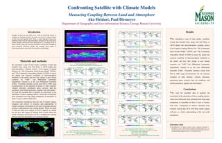
1. Materials and methods:
We calculated a suite of land surface variability (Latent and
Sensible Heat, along with Soil Water in 10CM depth) and
land-atmosphere coupling metrics (Two-Legged Coupling
Metrics) for “The Community Earth System Model” CESM1,
and “The Community Atmosphere Model” (CAM5) to assess
the spatial and seasonal variability of land-atmosphere
feedbacks in the model, and how they change in past climate
scenarios via “LME”. Last Millennium community
experiments, referred to as the Last Millennium Ensemble
(LME). “Ensemble members extend from 850 to 2006 using
reconstructions for the transient evolution of solar intensity,
volcanic emissions, greenhouse gases, aerosols, land use
conditions, and orbital parameters, together and individually.”
We used the ensemble data to quantify the uncertainty in the
calculation of these coupling metrics, which have historically
been estimated from long single simulations or ensembles of
short (1-year or shorter) hind casts.
The researchers hypothesize that the rate of climate change,
frequency and severity of extremes, and predictability of
climate variations will depend on the type of regional land use
practices implemented in the coming decades. While the study
of land use land cover change (LULCC) impacts on climate
are not new, this project is starting from a point where the
model consensus is that there will be a strengthened coupling
between land and atmosphere in a warming climate.
Results
We calculated a suite of land surface variability
(Latent and Sensible Heat, along with Soil Water in
10CM depth) and land-atmosphere coupling metrics
(Two-Legged Coupling Metrics) for “The Community
Earth System Model” CESM1, and “The Community
Atmosphere Model” (CAM5) to assess the spatial and
seasonal variability of land-atmosphere feedbacks in
the model, and how they change in past climate
scenarios via “LME”. Last Millennium community
experiments, referred to as the Last Millennium
Ensemble (LME). “Ensemble members extend from
850 to 2006 using reconstructions for the transient
evolution of solar intensity, volcanic emissions,
greenhouse gases, aerosols, land use conditions, and
orbital parameters, together and individually.”
Conclusions
We used the ensemble data to quantify the
uncertainty in the calculation of these coupling metrics,
which have historically been estimated from long single
simulations or ensembles of short (1-year or shorter)
hind casts. Comparison to metrics calculated from
remotely sensed data (R.S) with these model outputs
will give us a better understanding of the real world
mechanism.
Confronting Satellite with Climate Models
Measuring Coupling Between Land and Atmosphere
Ako Heidari, Paul Dirmeyer
Department of Geography and Geo-information Science, George Mason University
Literature cited
Otto-Bliesner, B.L., E.C. Brady, J. Fasullo, A. Jahn, L. Landrum, S. Stevenson, N.
Rosenbloom, A. Mai, G. Strand. Climate Variability and Change since 850 C.E.: An
Ensemble Approach with the Community Earth System Model (CESM), Bulletin of
the American Meteorological Society, 735-754 (May 2016 issue)
Introduction
Changes in land use and land cover, such as converting forests to
cropland or irrigating formerly dry areas, are known to impact climate
on the local and regional level. There is some indication from prior
modeling studies that the land-atmosphere interactions that cause these
climate impacts will become more pronounced in a warming world. In
order to further study this concept, researchers will perform simulations
using advanced numerical models and compare those results to
observational data to assess how the models are performing.
Fig. 3 Comparing the Impact of Land Use Land Cover Change on the Coupling between
Land and Atmosphere vs. Control Run, 10th
& 20th
Century.
Fig. 1 Terrestrial and Atmospheric Fluxes:
1)Soil Water in 10CM Depth 2)Latent Heat Flux 3)Sensible Heat Flux
Fig. 2Comparing the effect of Control Run vs. one single force
1)10th
Century, Impact of Control Run minus Land Use Land Cover Change
2)20th
Century, Same Comparison
3)Same Century, Different Comparison: Impact of Control Run minus Green House Gas
Fig. 3Comparing the effect of All Forces vs. one single force
1)10th
Century, Impact of All Forces minus Land Use Land Cover Change
2)15th
Century, Same Comparison
3)18th
Century, Same Comparison
4)19th
Century, Same Comparison
5)Same Century, Different Comparison: Latent Heat Coupling rather than Sensible
Heat