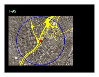
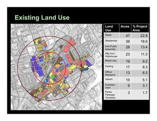
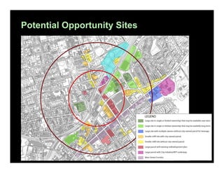
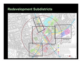
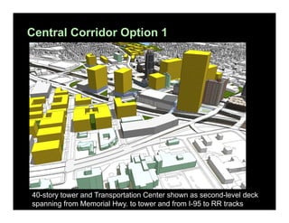
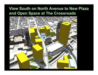
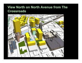
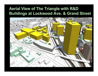
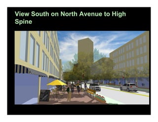
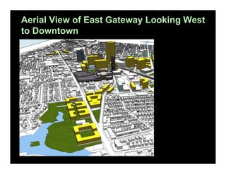
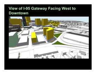
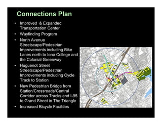
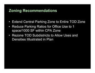
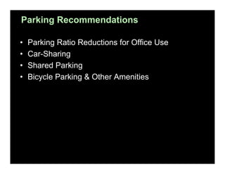
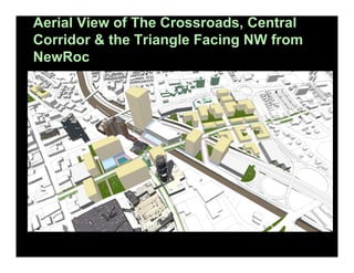
TOD Smart Growth Study
New Rochelle, New York

C S S
Project Background
The New York-Connecticut Sustainable Communities
Consortium, funded with a HUD Sustainable Communities
Regional Planning Grant, brought together cities, counties
and regional planning organizations to focus on how to
“leverage the most extensive and robust transit system in the
nation by developing livable communities with mixed-income
housing and employment at key nodes in the MTA MetroNorth Railroad and MTA Long Island Rail Road network.”
New Rochelle, as part of that Consortium, initiated this TOD
Smart Growth Study around the City’s downtown Intermodal
Transportation Hub.
The Old Boston Post Road
The Old Boston Post Road – “The King’s
Best Highway”
The Westchester Turnpike
The Road to White Plains
The 100% Corner
The New York and New Haven Railroad
I-95
I-95 and Related Development
New Rochelle’s Main Street in the Mid1920s
Existing Zoning
Existing Land Use
Land
Use

Acres

% Project
Area

Retail

47

22.8

Residential

38

18.6

Inst./Public
Assembly

28

13.4

Mfg./Ind./
Warehouse

23

11.3

Mixed Use

19

9.2

Parking

17

8.3

Office/
Research

13

6.5

Vacant

10

5.1

Entertainment

6

3.1

Parks/
Parkway/
Cemetery

3

1.7
Overarching Concept
• Creation of an active, mixed-use district with
convenient, safe and pleasant access to the New
Rochelle Transportation Center
Three Goals

•

Identify areas where significant development
opportunities exist and where new development can
enhance Downtown and existing neighborhoods

•

Identify streets and pathways to serve as the
primary corridors to the Transportation Center for
both existing neighborhoods and the new
development districts

•

Improve the environment in and around the
Transportation Center and create the opportunity for
streetscape and open space that enhance
Downtown and the transit rider’s experience.
Public Outreach
•
•
•
•
•

5 Steering Committee Meetings
The TOD public outreach process was done in conjunction with the
City’s Comprehensive Plan update
Public outreach meetings were conducted in the summer and fall of
2012
The City made it a priority to target hard to reach populations and
worked with the Housing Action Council retained by the consortium
Public Outreach Topics
– Neighborhoods and Housing
– Economic Development
– Mobility and Infrastructure
– Open Space
– Land Use and Zoning
– Urban Design and Preservation
Potential Opportunity Sites
Redevelopment Subdistricts
Final Project Boundaries
TOD Subdistricts

North Ave. Gateway –
The Triangle

I-95 Gateway

Central Corridor
East Gateway
Crossroads

West Gateway
Findings
1. Existing zoning in some areas, with height restrictions of two or three
floors and allowable auto-oriented uses, does not accommodate or
encourage the uses and densities desired in a TOD district.
2. Pedestrian and bicycle connections between the existing train station
and other subdistricts within the ½ mile radius need improvement.
3. Regional transportation improvements, including improvements to
Amtrak and the West Side Access Project, providing better
connections to NYC, will strengthen market for housing and
commercial space
4. The commercial real estate market in Westchester County is showing
strong growth.
5. There are opportunities for significant redevelopment in several
locations throughout the project area, but most of these opportunities
require parcel consolidation to create parcels of sufficient size.
6. Redevelopment potential around the existing train station provides
the opportunity for a new/expanded station to better serve transit
patrons.
Aerial View (from the South) of Conceptual
Development
North Ave. Gateway –
The Triangle
Central
Corridor
Crossroads

West Gateway

I-95 Gateway
East Gateway
Plan View of the Central Corridor in I-95/
Amtrak Corridor
Exit 16
Oblique View of Central Corridor from
Northwest
Oblique View of Central Corridor from the
South
Building Articulation
Central Corridor Option 1

40-story tower and Transportation Center shown as second-level deck
spanning from Memorial Hwy. to tower and from I-95 to RR tracks
Option 2: Central Corridor Oblique Aerial
View from South
Improved Rail Access
East side Access project to
Grand Central Terminal will
allow increased MetroNorth
service between New Rochelle
and Penn Station, including 4
new stations:
• Hunts Point
• Parkchester
• Morris Park
• Co-op City
Plan of The Crossroads
View South on North Avenue to New Plaza
and Open Space at The Crossroads
View North on North Avenue from The
Crossroads
Plan of North Avenue Gateway – The
Triangle
Aerial View of The Triangle with R&D
Buildings at Lockwood Ave. & Grand Street
Aerial View of The Triangle with
Conventional Office Towers
View South on North Avenue to High
Spine
Aerial View of The Crossroads, Central
Corridor & the Triangle Facing NW from
NewRoc
Plan of the West Gateway at Main &
Huguenot Streets
View of West Gateway Looking East to
Downtown
Plan of East Gateway
Aerial View of East Gateway Looking West
to Downtown
Plan of I-95 Gateway

Huguenot Ave.
View of I-95 Gateway Facing West to
Downtown
Summary of New Development Illustrated
Land Use

SF/Units

Residential

2,242 units

Retail

483,415 SF

Office*

5,580,529 SF*

R&D

1,484,048 SF*

Hotel

463 rooms

11,359 spaces
Total Spaces
Accommodated in
Structured Parking

Parking Spaces
Req’d. w/Current
CPA Ratios

Parking Spaces
Req’d. w/Revised
CPA Ratios

14,573 spaces

9,443 spaces

Note: R&D space would replace1,033,312 sf of office space.
Connections Plan
•
•
•

•

•

•

Improved & Expanded
Transportation Center
Wayfinding Program
North Avenue
Streetscape/Pedestrian
Improvements including Bike
Lanes north to Iona College and
the Colonial Greenway
Huguenot Street
Streetscape/Pedestrian
Improvements including Cycle
Track to Station
New Pedestrian Bridge from
Station/Crossroads/Central
Corridor across Tracks and I-95
to Grand Street in The Triangle
Increased Bicycle Facilities
Zoning Recommendations
• Extend Central Parking Zone to Entire TOD Zone
• Reduce Parking Ratios for Office Use to 1
space/1000 SF within CPA Zone
• Rezone TOD Subdistricts to Allow Uses and
Densities Illlustrated in Plan
Parking Recommendations
•
•
•
•

Parking Ratio Reductions for Office Use
Car-Sharing
Shared Parking
Bicycle Parking & Other Amenities
Next Steps
1. The City should initiate a Master Plan Development Process of the
highlighted subdistricts with zoning changes and transportation /
transit analysis. The Master Plan Design would use this TOD report,
the Columbia University Study and the Nelson Nygaard study;
simultaneously the City will be updating its Comprehensive Plan.
2. Prioritize subdistricts. It is recommended that the Central Corridor be
given the highest priority. The first phase of work for each of these
sub-districts will most likely be City-owned parcels.
3. Adopt new zoning regulations to support desired development.
4. Work with property owners to consolidate parcels.
5. Explore with MetroNorth and Amtrak the potential for an improved
and expanded Transportation Center.
Aerial View of The Crossroads, Central
Corridor & the Triangle Facing NW from
NewRoc

New Rochelle TOD Study

  • 1.
    TOD Smart GrowthStudy New Rochelle, New York C S S
  • 2.
    Project Background The NewYork-Connecticut Sustainable Communities Consortium, funded with a HUD Sustainable Communities Regional Planning Grant, brought together cities, counties and regional planning organizations to focus on how to “leverage the most extensive and robust transit system in the nation by developing livable communities with mixed-income housing and employment at key nodes in the MTA MetroNorth Railroad and MTA Long Island Rail Road network.” New Rochelle, as part of that Consortium, initiated this TOD Smart Growth Study around the City’s downtown Intermodal Transportation Hub.
  • 3.
    The Old BostonPost Road
  • 4.
    The Old BostonPost Road – “The King’s Best Highway”
  • 5.
  • 6.
    The Road toWhite Plains
  • 7.
  • 8.
    The New Yorkand New Haven Railroad
  • 9.
  • 10.
    I-95 and RelatedDevelopment
  • 11.
    New Rochelle’s MainStreet in the Mid1920s
  • 12.
  • 13.
    Existing Land Use Land Use Acres %Project Area Retail 47 22.8 Residential 38 18.6 Inst./Public Assembly 28 13.4 Mfg./Ind./ Warehouse 23 11.3 Mixed Use 19 9.2 Parking 17 8.3 Office/ Research 13 6.5 Vacant 10 5.1 Entertainment 6 3.1 Parks/ Parkway/ Cemetery 3 1.7
  • 14.
    Overarching Concept • Creationof an active, mixed-use district with convenient, safe and pleasant access to the New Rochelle Transportation Center
  • 15.
    Three Goals • Identify areaswhere significant development opportunities exist and where new development can enhance Downtown and existing neighborhoods • Identify streets and pathways to serve as the primary corridors to the Transportation Center for both existing neighborhoods and the new development districts • Improve the environment in and around the Transportation Center and create the opportunity for streetscape and open space that enhance Downtown and the transit rider’s experience.
  • 16.
    Public Outreach • • • • • 5 SteeringCommittee Meetings The TOD public outreach process was done in conjunction with the City’s Comprehensive Plan update Public outreach meetings were conducted in the summer and fall of 2012 The City made it a priority to target hard to reach populations and worked with the Housing Action Council retained by the consortium Public Outreach Topics – Neighborhoods and Housing – Economic Development – Mobility and Infrastructure – Open Space – Land Use and Zoning – Urban Design and Preservation
  • 17.
  • 18.
  • 19.
  • 20.
    TOD Subdistricts North Ave.Gateway – The Triangle I-95 Gateway Central Corridor East Gateway Crossroads West Gateway
  • 21.
    Findings 1. Existing zoningin some areas, with height restrictions of two or three floors and allowable auto-oriented uses, does not accommodate or encourage the uses and densities desired in a TOD district. 2. Pedestrian and bicycle connections between the existing train station and other subdistricts within the ½ mile radius need improvement. 3. Regional transportation improvements, including improvements to Amtrak and the West Side Access Project, providing better connections to NYC, will strengthen market for housing and commercial space 4. The commercial real estate market in Westchester County is showing strong growth. 5. There are opportunities for significant redevelopment in several locations throughout the project area, but most of these opportunities require parcel consolidation to create parcels of sufficient size. 6. Redevelopment potential around the existing train station provides the opportunity for a new/expanded station to better serve transit patrons.
  • 22.
    Aerial View (fromthe South) of Conceptual Development North Ave. Gateway – The Triangle Central Corridor Crossroads West Gateway I-95 Gateway East Gateway
  • 23.
    Plan View ofthe Central Corridor in I-95/ Amtrak Corridor Exit 16
  • 24.
    Oblique View ofCentral Corridor from Northwest
  • 25.
    Oblique View ofCentral Corridor from the South
  • 26.
  • 27.
    Central Corridor Option1 40-story tower and Transportation Center shown as second-level deck spanning from Memorial Hwy. to tower and from I-95 to RR tracks
  • 28.
    Option 2: CentralCorridor Oblique Aerial View from South
  • 29.
    Improved Rail Access Eastside Access project to Grand Central Terminal will allow increased MetroNorth service between New Rochelle and Penn Station, including 4 new stations: • Hunts Point • Parkchester • Morris Park • Co-op City
  • 30.
    Plan of TheCrossroads
  • 31.
    View South onNorth Avenue to New Plaza and Open Space at The Crossroads
  • 32.
    View North onNorth Avenue from The Crossroads
  • 33.
    Plan of NorthAvenue Gateway – The Triangle
  • 34.
    Aerial View ofThe Triangle with R&D Buildings at Lockwood Ave. & Grand Street
  • 35.
    Aerial View ofThe Triangle with Conventional Office Towers
  • 36.
    View South onNorth Avenue to High Spine
  • 37.
    Aerial View ofThe Crossroads, Central Corridor & the Triangle Facing NW from NewRoc
  • 38.
    Plan of theWest Gateway at Main & Huguenot Streets
  • 39.
    View of WestGateway Looking East to Downtown
  • 40.
    Plan of EastGateway
  • 41.
    Aerial View ofEast Gateway Looking West to Downtown
  • 42.
    Plan of I-95Gateway Huguenot Ave.
  • 43.
    View of I-95Gateway Facing West to Downtown
  • 44.
    Summary of NewDevelopment Illustrated Land Use SF/Units Residential 2,242 units Retail 483,415 SF Office* 5,580,529 SF* R&D 1,484,048 SF* Hotel 463 rooms 11,359 spaces Total Spaces Accommodated in Structured Parking Parking Spaces Req’d. w/Current CPA Ratios Parking Spaces Req’d. w/Revised CPA Ratios 14,573 spaces 9,443 spaces Note: R&D space would replace1,033,312 sf of office space.
  • 45.
    Connections Plan • • • • • • Improved &Expanded Transportation Center Wayfinding Program North Avenue Streetscape/Pedestrian Improvements including Bike Lanes north to Iona College and the Colonial Greenway Huguenot Street Streetscape/Pedestrian Improvements including Cycle Track to Station New Pedestrian Bridge from Station/Crossroads/Central Corridor across Tracks and I-95 to Grand Street in The Triangle Increased Bicycle Facilities
  • 46.
    Zoning Recommendations • ExtendCentral Parking Zone to Entire TOD Zone • Reduce Parking Ratios for Office Use to 1 space/1000 SF within CPA Zone • Rezone TOD Subdistricts to Allow Uses and Densities Illlustrated in Plan
  • 47.
    Parking Recommendations • • • • Parking RatioReductions for Office Use Car-Sharing Shared Parking Bicycle Parking & Other Amenities
  • 48.
    Next Steps 1. TheCity should initiate a Master Plan Development Process of the highlighted subdistricts with zoning changes and transportation / transit analysis. The Master Plan Design would use this TOD report, the Columbia University Study and the Nelson Nygaard study; simultaneously the City will be updating its Comprehensive Plan. 2. Prioritize subdistricts. It is recommended that the Central Corridor be given the highest priority. The first phase of work for each of these sub-districts will most likely be City-owned parcels. 3. Adopt new zoning regulations to support desired development. 4. Work with property owners to consolidate parcels. 5. Explore with MetroNorth and Amtrak the potential for an improved and expanded Transportation Center.
  • 49.
    Aerial View ofThe Crossroads, Central Corridor & the Triangle Facing NW from NewRoc