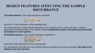
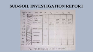
The document summarizes the key aspects of subsurface investigations for engineering projects. It discusses the purposes of site investigations, planning exploration programs, common exploration techniques like boreholes and sampling methods, and how to document and report the findings in a subsurface investigation report. The goal is to efficiently obtain essential subsurface data to inform foundation design and construction methods while minimizing costs.
Geological site investigation for Civil Engineering FoundationsDr.Anil Deshpande
Aim to introduce Preliminary geological Investigations for fulfilling knowledge about geological need to determine engineering properties of foundation rocks and check the suitability & feasibility of site wherein selection of site plays a crucial role to avoid future implications in civil engineering projects.
The process of determining the layers of natural soil deposits that will underlie a proposed structure and their physical properties is generally referred to as site investigation.
1. Site Investgation.pptxDebre Markos University Technology College Departmen...teseraaddis1
Soil Exploration
“ The process of exploring to characterize or define small scale properties of substrata at construction sites is unique to geotechnical engineering.
In other engineering disciplines, material properties are specified during design, or before construction or manufacture, and then controlled to meet the specification. Unfortunately, subsurface properties cannot be specified; they must be deduced through exploration.” Charles H. Dowding (1979).
A site investigation simply is the process of the collection of information, the appraisal of data, assessment, and reporting without which the hazards in the ground beneath the site cannot be known
Foundation and its functions
Essential requirements
Sub soil exploration and Site exploration
Methods of site exploration
Settlement of foundations
Causes of failure of foundation and remedial measures
About Subsurface investigation, Depth of foundation, Significant depth, Types of investigation, Steps involved, Methods of boring, Types of samples and samplers, Core recovery and RQD.
NUMERICAL SIMULATIONS OF HEAT AND MASS TRANSFER IN CONDENSING HEAT EXCHANGERS...ssuser7dcef0
Power plants release a large amount of water vapor into the
atmosphere through the stack. The flue gas can be a potential
source for obtaining much needed cooling water for a power
plant. If a power plant could recover and reuse a portion of this
moisture, it could reduce its total cooling water intake
requirement. One of the most practical way to recover water
from flue gas is to use a condensing heat exchanger. The power
plant could also recover latent heat due to condensation as well
as sensible heat due to lowering the flue gas exit temperature.
Additionally, harmful acids released from the stack can be
reduced in a condensing heat exchanger by acid condensation. reduced in a condensing heat exchanger by acid condensation.
Condensation of vapors in flue gas is a complicated
phenomenon since heat and mass transfer of water vapor and
various acids simultaneously occur in the presence of noncondensable
gases such as nitrogen and oxygen. Design of a
condenser depends on the knowledge and understanding of the
heat and mass transfer processes. A computer program for
numerical simulations of water (H2O) and sulfuric acid (H2SO4)
condensation in a flue gas condensing heat exchanger was
developed using MATLAB. Governing equations based on
mass and energy balances for the system were derived to
predict variables such as flue gas exit temperature, cooling
water outlet temperature, mole fraction and condensation rates
of water and sulfuric acid vapors. The equations were solved
using an iterative solution technique with calculations of heat
and mass transfer coefficients and physical properties.
Forklift Classes Overview by Intella PartsIntella Parts
Discover the different forklift classes and their specific applications. Learn how to choose the right forklift for your needs to ensure safety, efficiency, and compliance in your operations.
For more technical information, visit our website https://intellaparts.com
Final project report on grocery store management system..pdfKamal Acharya
In today’s fast-changing business environment, it’s extremely important to be able to respond to client needs in the most effective and timely manner. If your customers wish to see your business online and have instant access to your products or services.
Online Grocery Store is an e-commerce website, which retails various grocery products. This project allows viewing various products available enables registered users to purchase desired products instantly using Paytm, UPI payment processor (Instant Pay) and also can place order by using Cash on Delivery (Pay Later) option. This project provides an easy access to Administrators and Managers to view orders placed using Pay Later and Instant Pay options.
In order to develop an e-commerce website, a number of Technologies must be studied and understood. These include multi-tiered architecture, server and client-side scripting techniques, implementation technologies, programming language (such as PHP, HTML, CSS, JavaScript) and MySQL relational databases. This is a project with the objective to develop a basic website where a consumer is provided with a shopping cart website and also to know about the technologies used to develop such a website.
This document will discuss each of the underlying technologies to create and implement an e- commerce website.
CW RADAR, FMCW RADAR, FMCW ALTIMETER, AND THEIR PARAMETERSveerababupersonal22
It consists of cw radar and fmcw radar ,range measurement,if amplifier and fmcw altimeterThe CW radar operates using continuous wave transmission, while the FMCW radar employs frequency-modulated continuous wave technology. Range measurement is a crucial aspect of radar systems, providing information about the distance to a target. The IF amplifier plays a key role in signal processing, amplifying intermediate frequency signals for further analysis. The FMCW altimeter utilizes frequency-modulated continuous wave technology to accurately measure altitude above a reference point.
Overview of the fundamental roles in Hydropower generation and the components involved in wider Electrical Engineering.
This paper presents the design and construction of hydroelectric dams from the hydrologist’s survey of the valley before construction, all aspects and involved disciplines, fluid dynamics, structural engineering, generation and mains frequency regulation to the very transmission of power through the network in the United Kingdom.
Author: Robbie Edward Sayers
Collaborators and co editors: Charlie Sims and Connor Healey.
(C) 2024 Robbie E. Sayers
Saudi Arabia stands as a titan in the global energy landscape, renowned for its abundant oil and gas resources. It's the largest exporter of petroleum and holds some of the world's most significant reserves. Let's delve into the top 10 oil and gas projects shaping Saudi Arabia's energy future in 2024.
We have compiled the most important slides from each speaker's presentation. This year’s compilation, available for free, captures the key insights and contributions shared during the DfMAy 2024 conference.
Sachpazis:Terzaghi Bearing Capacity Estimation in simple terms with Calculati...Dr.Costas Sachpazis
Terzaghi's soil bearing capacity theory, developed by Karl Terzaghi, is a fundamental principle in geotechnical engineering used to determine the bearing capacity of shallow foundations. This theory provides a method to calculate the ultimate bearing capacity of soil, which is the maximum load per unit area that the soil can support without undergoing shear failure. The Calculation HTML Code included.
Student information management system project report ii.pdfKamal Acharya
Our project explains about the student management. This project mainly explains the various actions related to student details. This project shows some ease in adding, editing and deleting the student details. It also provides a less time consuming process for viewing, adding, editing and deleting the marks of the students.
Student information management system project report ii.pdf
Module- 3 Subsurface Investigation.pptx
1. Module-3 Subsurface Investigation
Prepared By:- Chaudhari Silas
Civil Engineering Department
Pacific School of Engineering
Pacific School
of
Engineering
Gujarat
Technological
University
Semester : 5th
Subject: Soil Mechanics (3150615)
Civil Engineering Department
2. INTRODUCTION
Site investigations or subsurface explorations are done for obtaining the
information about subsurface conditions at the site of proposed construction.
Site investigations in one form or the other is generally required for every big
engineering project. Information about the surface and sub-surface features is
essential for the design of structures and for planning construction techniques.
Site investigations consist of determining the profile of the natural soil
deposits at the site, taking the soil samples and determining the engineering
properties of the soils. It also includes in-situ testing of the soils.
3. Site investigations are generally done to obtain the information
that is useful for one or more of the following purposes.
(1) To select the type and depth of foundation for a given structure.
(2) To determine the bearing capacity of the soil.
(3) To estimate the probable maximum and differential settlements.
(4) To establish the ground water level and to determine the properties of water.
(5) To predict the lateral earth pressure against retaining walls and abutments.
(6) To select suitable construction techniques.
(7) To predict and to solve potential foundation problems.
(8) To ascertain the suitability of the soil as a construction material.
(9) To investigate the safety of the existing structures and to suggest the remedial measures.
The relevant information is obtained by drilling holes, taking the soil samples and determining
the index and engineering properties of the soil. In-situ tests are also conducted to determine
the properties of the soils in natural conditions.
4. PLANNING A SUBSURFACE EXPLORATION PROGRAMME
• A sub-surface exploration programme depends upon the type of the structure to be built and upon the variability of
the strata at the proposed site. The extent of sub-surface exploration is closely related to the relative cost of the
investigations and that of the entire project for which it is undertaken. In general, the more detailed the investigations are
done, the more is known about the sub-surface conditions. As a result, the greater economy can be achieved in the
construction of the project because the element of uncertainty is considerably reduced. However, a limit is reached
when the cost of investigations outweighs any saving in the cost of the project, and it increases the overall cost. It would
not be economical to have investigations beyond that limit.
• The extent of investigations would also depend upon the location of the project. A small house in an already built-up
area would not require much exploration. On the other hand, if the house is to be built in a newly developed area, a
detailed investigation would be required to ascertain the location of different soil strata and their physical characteristics.
If a multi-storeyed building is to be constructed, extensive sub-surface explorations would be necessary. These
buildings impose very heavy loads and the zone of influence is also very deep. It would, therefore, be more desirable to
invest some amount on sub-surface exploration than to overdesign the building and make it costlier.
• Planning of a sub-surface exploration programme is a difficult task. Besides a thorough knowledge of soil engineering, it
requires experience and engineering judgment. Sometimes, the exploration programme has to be changed as the
investigations progress. As the variability of the soil strata is found to increase, the extent of investigations is also
increased. On the other hand, if the site is found to be underlain by uniform deposits, the extent of investigations is
decreased.
• In general, the aim of the investigations should be to get the maximum information that is useful in the design and
construction of the project at a minimum cost. The cost of site investigations generally varies between 0.05 to 0.2%
of the total cost of the entire structure. In some unusual conditions, the cost may be even upto 1%.
5. STAGES IN SUB-SURFACE EXPLORATIONS
Sub-surface explorations are generally carried out in three stages:
(1) Reconnaissance. Site reconnaissance is the first step in a sub-surface exploration programme. It includes a
visit to the site and to study the maps and other relevant records. It helps in deciding future programme of
site investigations, scope of work, methods of exploration to be adopted, types of samples to be taken and
the laboratory testing and in-situ testing.
(2) Preliminary Explorations. The aim of a preliminary exploration is to determine the depth, thickness, extent
and composition of each soil stratum at the site. The depth of the bed rock and the ground water table is
also determined. The preliminary explorations are generally in the form of a few borings or test pits. Tests are
conducted with cone penetrometers and sounding rods to obtain information about the strength and
compressibility of soils. Geophysical methods are also used in preliminary explorations for locating the
boundaries of different strata.
(3) Detailed Explorations. The purpose of the detailed explorations is to determine the engineering properties
of the soils in different strata. It includes an extensive boring programme, sampling and testing of the
samples in a laboratory. Field tests, such as vane shear tests, plate load tests and permeability tests, are
conducted to determine the properties of the soils in natural state. The tests for the determination of
dynamic properties are also carried out, if required. For complex projects involving heavy structures, such as
bridges, dams, multi-storey buildings, it is essential to have detailed explorations. However, for small projects,
especially at sites where the strata are uniform, detailed investigations may not be require. The design of such
projects is generally based on the data collected during reconnaissance and preliminary explorations.
6. TYPES OF SOIL SAMPLES
Soil samples are obtained during sub-surface exploration to determine the engineering
properties of the soils and rocks. Soil samples are generally classified into two categories:
(1) Disturbed samples. These are the samples in which the natural structure of the soil gets
disturbed during sampling. However, these samples represent the composition and the
mineral content of the soil. Disturbed samples can be used to determine the index
properties of the soil, such as grain size, plasticity characteristics, specific gravity.
(2) Undisturbed samples. These are the samples in which the natural structure of the soil
and the water content are retained. However, it may be mentioned that it is impossible to
get truly undisturbed sample. Some disturbance is inevitable during sampling, even when
the utmost care is taken. Even the removal of the sample from the ground produces a
change in the stresses and causes disturbances.
Undisturbed samples are used for determining the engineering properties of the soil, such
a compressibility, shear strength, and permeability. Some index properties such as
shrinkage limit can also be determined. The smaller the disturbance, the greater would be
the reliability of the results.
7. DESIGN FEATURES AFFECTING THE SAMPLE
DISTURBANCE
The disturbance of the soil depends mainly upon the following
design features:
(1) Area ratio. The area ratio is defined as
Ar =
Maximum cross−sectional area of the cutting edge
Area of the soil sample
x 100
Fig. shows the lower portion of a sampler. The area ratio can be
expressed as
where D1 = inner diameter of the cutting edge, D₂ = outer diameter
of the cutting edge.
For obtaining good quality undisturbed samples, the area ratio
should be 10 percent or less (Hvorslev, 1949).
8. DESIGN FEATURES AFFECTING THE SAMPLE
DISTURBANCE
(2) Inside clearance. The inside clearance is defined
where D3 = inner diameter of the sampling tube.
The inside clearance allows clastic expansion of the sample when it enters the tube. It helps is
reducing the frictional drag on the sample. For an undisturbed sample, the inside clearance should
be between 0.5 and 3 percent.
(3) Outside clearance. The outside clearance is defined as
where D4, outer diameter of the sampling tube.
For reducing the driving force, the outside clearance should be as small as possible. Normally, it lies
between zero and 2 percent.
9. (4) Inside wall friction. The friction on the inside wall causes
disturbance of the sample. The inside surface of the sampler should
be smooth. It is usually smeared with oil before use to reduce
friction.
(5) Design of non-return valve. The non-return valve provided on
the sampler should be of proper design. It should have an orifice of
large area to allow air, water or slurry to escape quickly when the
sampler is driven. It should immediately close when the sampler is
withdrawn.
(6) Method of applying force. The degree of disturbance depends
upon the method of applying force during sampling and upon the
rate of penetration of the sampler. For obtaining undisturbed
samples, the sampler should be pushed and not driven.
11. SPLIT-SPOON SAMPLER
The most commonly used sampler for obtaining a disturbed sample of
the soil is the standard split-poon sampler. It consist of three parts
i. Driving shoe made of tool-steel, about 75mm long,
ii. steel tube about 450 mm long, split longitudinally in two halves,
and
iii. coupling at the top of the tube about 150 mm long. The inside
diameter of the split tube is 38 mm and the outside diameter is
50.0 mm. The coupling head may be provided with a check valve
and 4 venting ports of 10 mm dia to improve sample recovery. This
sampler is also used in conducting standard penetration test.
After the bore hole has been made, the sampler is attached to the
drilling rod and lowered into the hole.
12. SPLIT-SPOON SAMPLER
• The sample is collected by jacking or forcing the sampler into the soil by repeated
blows of a drop hammer The sampler is then withdrawn. The split tube is separated
after removing the shoe and the coupling and the sample is taken out. It is then
placed in a container, sealed, and transported to the laboratory.
• If the soil encountered in the bore hole is fine sand and it lies below the water
table, the sample recovery becomes difficult. For such soils, a spring-core catcher
device is used to aid recovery. As the sampler is lifted, the springs close and form a
dome and retain the sample.
• While taking samples, care shall be taken to ensure that the water level in the hole
is maintained slightly higher than the piezometric level at the bottom of the hole. It
is necessary to prevent quick sand conditions.
• The split tube may be provided with a thin metal or plastic tube liner to protect the
sample and to hold it together. After the sample has been collected, the liner and
the sample it contains are removed from the tube and the ends are sealed.
14. SCRAPER BUCKET SAMPLER
• If a sandy deposit contains pebbles, it is not possible to obtain samples by
standard split-spoon sampler or split-spoon sampler fitted with a spring
core catcher. The pebbles come in-between the springs and prevent their
closure. For such deposits, a scraper bucket sampler can be used.
• A scraper bucket sampler consists of a driving point which is attached to its
bottom end. There is a vertical slit in the upper portion of the sampler. As
the sampler is rotated, scrapings of the soil enter the sampler through the
slit. When the sampler is filled with the scrapings, it is lifted. Although the
sample is quite disturbed, it is still representative.
• A scraper bucket sampler can also be used for obtaining the samples of
cohesionless soils below the water table.
16. SHELBY TUBES AND THIN-WALLED SAMPLERS
• Shelby tubes are thin wall tube samplers made of seamless steel. The
outside diameter of the tube may be between 40 to 125 mm. The
commonly used samplers have the outside diameter of either 50.8
mm or 76.2 mm. The bottom of the tube is sharpened and beveled,
which acts as a cutting edge. The area ratio is less than 15% and the
inside clearance is between 0.5 to 3%.
• Fig. shows a thin-walled sampler (IS: 2132-1972). The length of the
tube is 5 to 10 times the 12mm diameter for sandy soils and 10 to 15
times the diameter for clayey soils. The diameter generally varies
between 40 and 125 mm, and the thickness varies from 1.25 to 3.15
mm.
17. SHELBY TUBES AND THIN-WALLED SAMPLERS
• The sampler tube is attached to the drilling rod and lowered
to the bottom of the bore hole. It is then pushed into the
soil. Care shall be taken to push the tube into the soil by a
continuous rapid motion without impact or twisting The
tube should be pushed to the length provided for the
sample. At least 5 minutes after pushing the tube into its
final position, the tube is turned 2 revolutions to shear the
sample off at the bottom before it is withdrawn. The tube is
taken out and its ends are sealed before transportation.
• Shelby tubes are used for obtaining undisturbed samples of
clay.
19. Piston Sampler
• A piston sampler consists of a thin-walled tube with a piston inside. The piston
keeps the lower end of the sampling tube closed when the sampler is lowered to
the bottom of the hole. After the sampler has been lowered to the desired depth,
the piston is prevented from moving downward by a suitable arrangement, which
differs in different types of piston samplers. The thin tube sampler is pushed past
the piston to obtain the sample. The piston remains in close contact with the top of
the sample.
• The presence of the piston prevents rapid squeezing of the soft soils into the tube
and reduces the disturbance of the sample. A vacuum is created on the top of the
sample, which helps in retaining the sample. During the withdrawal of the sampler,
the piston provides protection against the water pressure which otherwise would
have occurred on the top of the sample.
• Piston samplers are used for getting undisturbed soil samples from soft and
sensitive clays.
20. DENISON SAMPLER
• The Denison sampler is a double-walled sampler. The outer barrel rotates and cuts
into the soil. The sample is obtained in the inner barrel. The inner barrel is provided
with a liner. It may also be provided with a basket-type core retainer.
• The sampler is lowered to the bottom of the drilled hole. A downward force is
applied on the top of the sampler. A fluid under pressure is introduced through the
inner barrel to cool the coring bit when the outer barrel rotates The fluid returns
through the annular space between the two barrels. The rotation of the outer barrel
is continued till the required length of the sample is obtained.
• The Denison sampler is mainly used for obtaining samples of stiff to hard cohesive
soils and slightly cohesive sands. However, it cannot be used for gravelly soils, loose
cohesionless sands and silts below ground water table and very soft cohesive soils.
• The Denison sampler gives a sample 5 (140 mm) in diameter and 20 inches (508 mm)
long, Care is needed in adjusting the speed of rotation, the pressure on drilling bit
and the velocity of wash water when drilling in soils and very friable rocks.
21. SUB-SOIL INVESTIGATION REPORT
• A sub-soil investigation report should contain the data obtained from bore holes, site
observations and laboratory results. It should also give the recommendations about the
suitable type of foundation, allowable soil pressure and expected settlements.
• It is essential to give a complete and accurate record of data collected. Each bore hole
should be identified by a code number. The location of each bore hole should be fixed by
measurement of its distance or angles from some permanent feature. All relevant data for
the bore hole is recorded in a boring log. A boring log gives the description or classification
of various strata encountered at different depths. Any additional information that is
obtained in the field, such as soil consistency, unconfined compression strength, standard
penetration test, cone penetration test, is also indicated on the boring log. It should also
show the water table. If the laboratory tests have been conducted, the information about
index properties, compressibility, shear strength, permeability, etc. should also be provided.
• The data obtained from a series of bore holes is presented in the form of a sub-surface
profile. A subsurface profile is a vertical section through the ground along the line of
exploration. It indicates the boundaries of different strata, along with their classification. It is
important to remember that conditions between bore holes are estimated by interpolation,
which may not be correct. Obviously, the larger the number of holes, the more accurate is
the sub-surface profile.
23. SUB-SOIL INVESTIGATION REPORT
The site investigation report should contain the discussion of the results. The
discussion should be clear and concise The recommendations about the type and
depth of foundation, allowable soil pressure and expected settlements should be
specific. The main findings of the report are given in conclusions.
A soil exploration report generally consists of the following.
1. Introduction, which gives the scope of the investigation.
2. Description of the proposed structure, the location and the geological conditions
at the site.
3. Details of the field exploration programme, indicating the number of borings,
their location and depths.
4. Details of the methods of exploration.
5. General description of the sub-soil conditions as obtained from in-situ tests, such
as standard penetration test, cone test.
6. Details of the laboratory test conducted on the soil samples obtained and the
results obtained.
25. SUB-SOIL INVESTIGATION REPORT
7. Depth of the ground water table and the changes in water levels.
8. Discussion of the results.
9. Recommendation about the allowable bearing pressure, the type of
foundation or structure.
10. Conclusions. The main findings of investigations should be clearly
stated. It should be brief but should mention the salient points.
Limitations of the investigations should also be briefly stated.