Downloaded 13 times

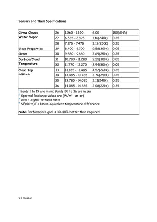
![Sensors and Their Specifications
Primary Use Band Bandwidth1 Spectral Required
Radiance2 SNR3
Land/Cloud/Aerosols 1 620 - 670 21.8 128
Boundaries 2 841 - 876 24.7 201
Land/Cloud/Aerosols 3 459 - 479 35.3 243
Properties 4 545 - 565 29.0 228
5 1230 - 1250 5.4 74
6 1628 - 1652 7.3 275
7 2105 - 2155 1.0 110
Ocean Color/ 8 405 - 420 44.9 880
Phytoplankton/ 9 438 - 448 41.9 838
Biogeochemistry
10 483 - 493 32.1 802
11 526 - 536 27.9 754
12 546 - 556 21.0 750
13 662 - 672 9.5 910
14 673 - 683 8.7 1087
15 743 - 753 10.2 586
16 862 - 877 6.2 516
Atmospheric 17 890 - 920 10.0 167
Water Vapor 18 931 - 941 3.6 57
19 915 - 965 15.0 250
Primary Use Band Bandwidth1 Spectral Required
Radiance2 NE[delta]T(K)4
Surface/Cloud 20 3.660 - 3.840 0.45(300K) 0.05
Temperature 21 3.929 - 3.989 2.38(335K) 2.00
22 3.929 - 3.989 0.67(300K) 0.07
23 4.020 - 4.080 0.79(300K) 0.07
Atmospheric 24 4.433 - 4.498 0.17(250K) 0.25
Temperature 25 4.482 - 4.549 0.59(275K) 0.25
S K Diwakar](https://image.slidesharecdn.com/modis-130414090652-phpapp01/85/MODIS-2-320.jpg)

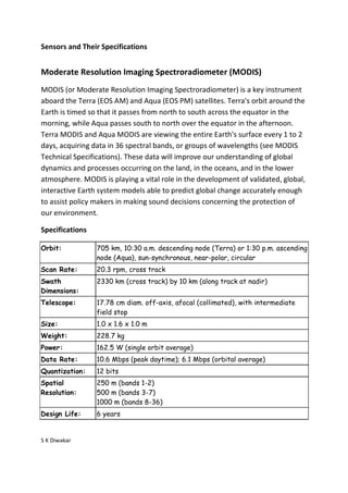
The document summarizes the specifications of the Moderate Resolution Imaging Spectroradiometer (MODIS) instruments aboard NASA's Terra and Aqua satellites. MODIS views the entire Earth every 1-2 days, acquiring data in 36 spectral bands to observe land, oceans, and the lower atmosphere. Key specifications of MODIS include its 705 km sun-synchronous orbit, 2330 km swath width, 36 spectral bands ranging from 0.4 to 14.4 μm, and spatial resolutions ranging from 250 m to 1000 m. MODIS data improves understanding of global climate processes and assists policymakers in environmental decision-making.