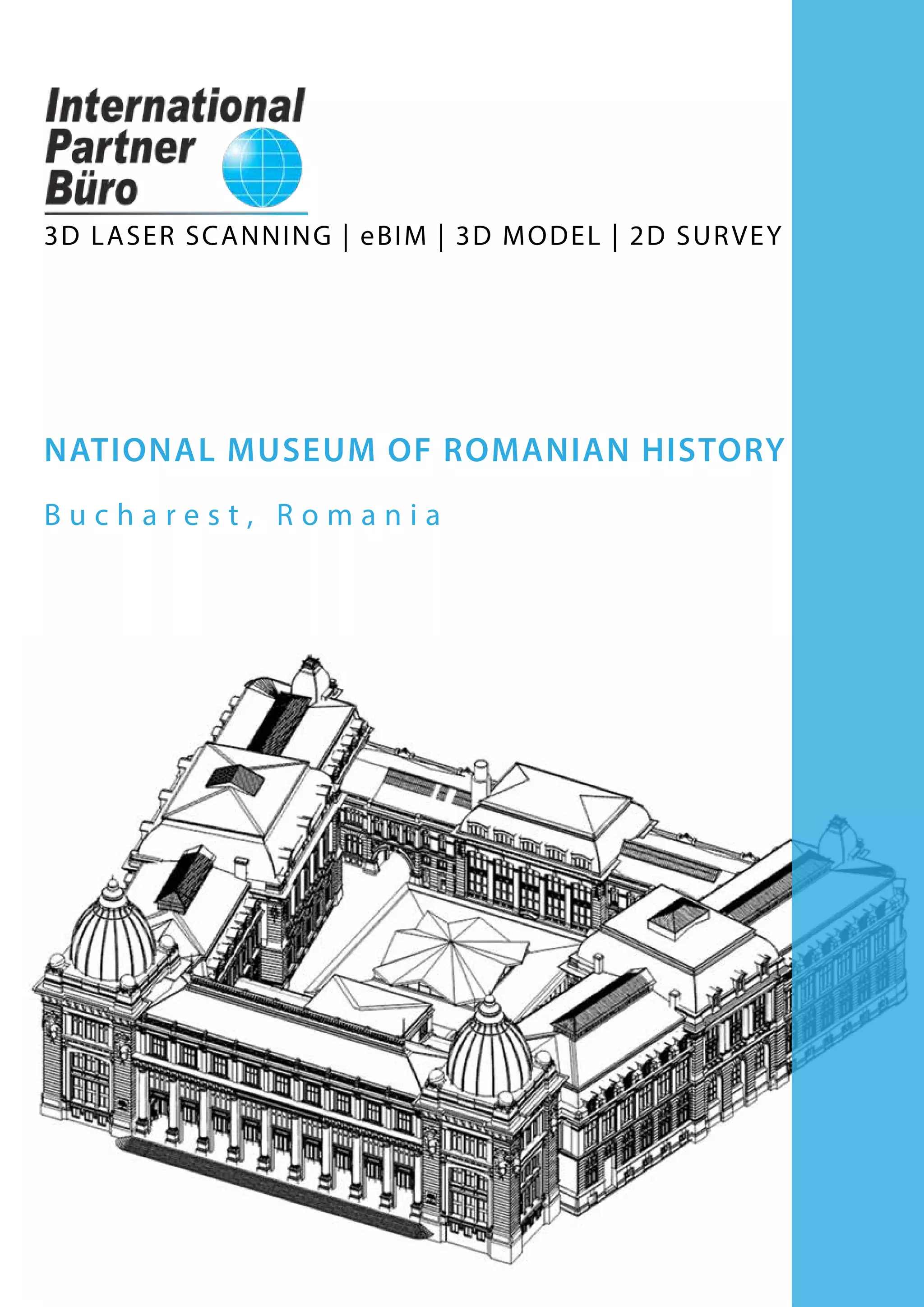
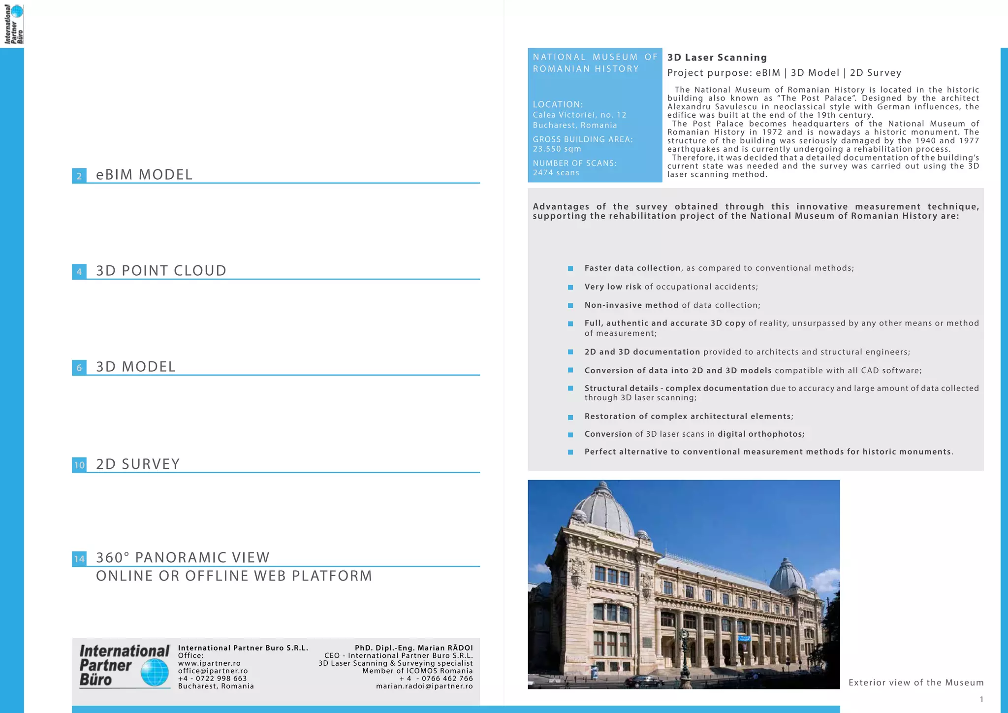
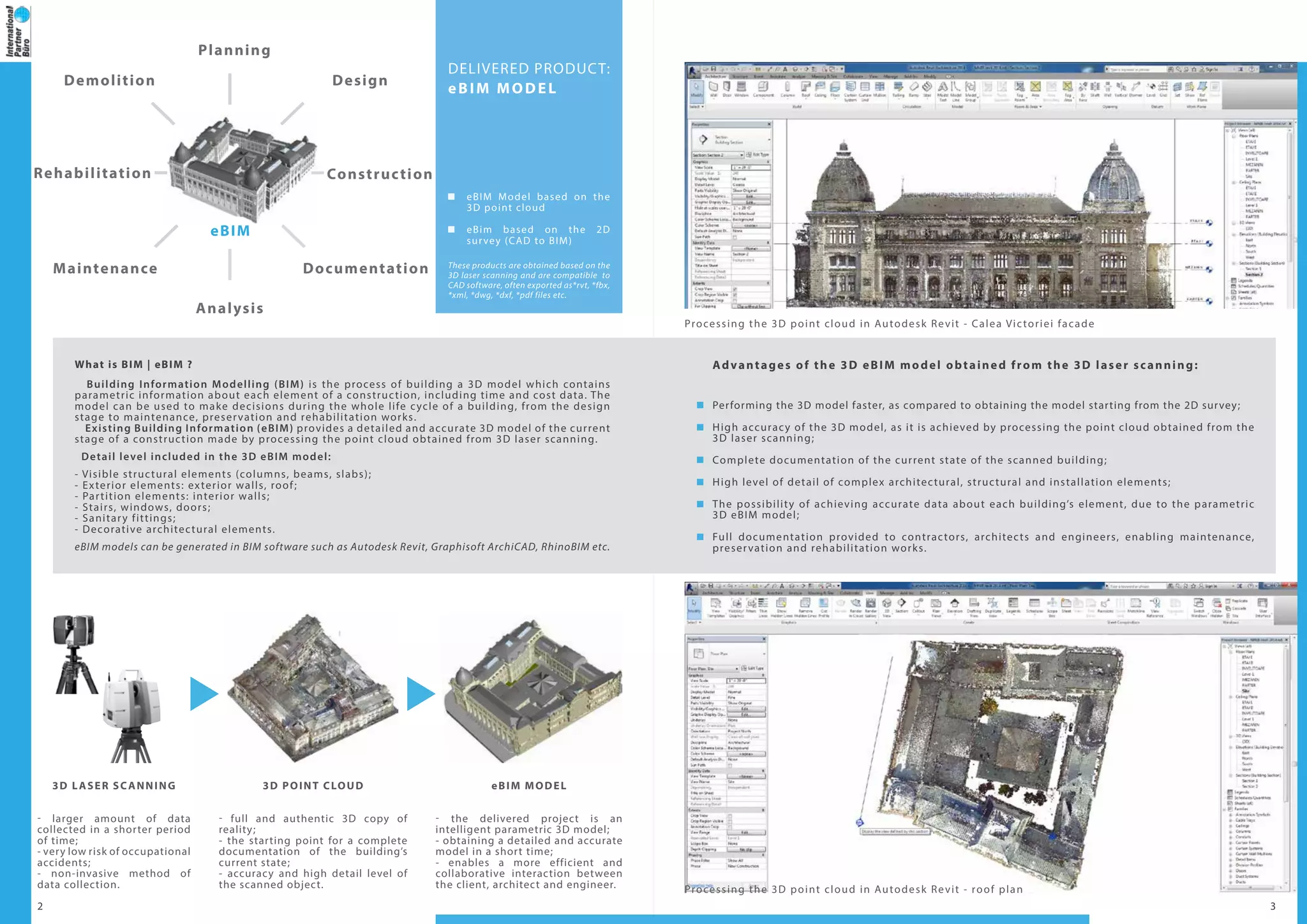
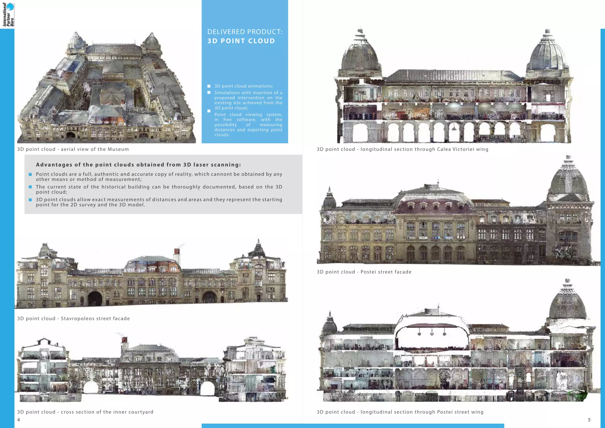
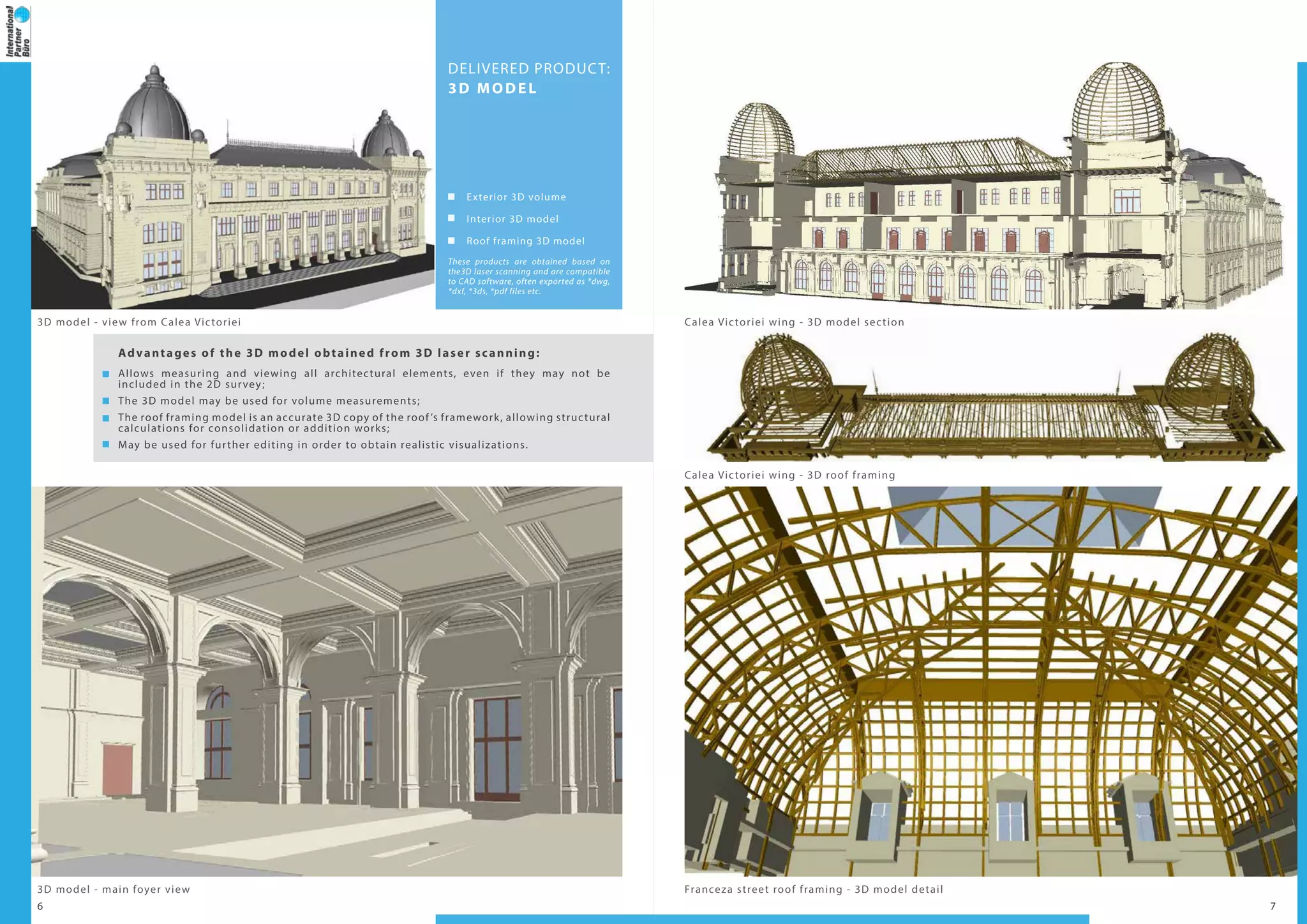
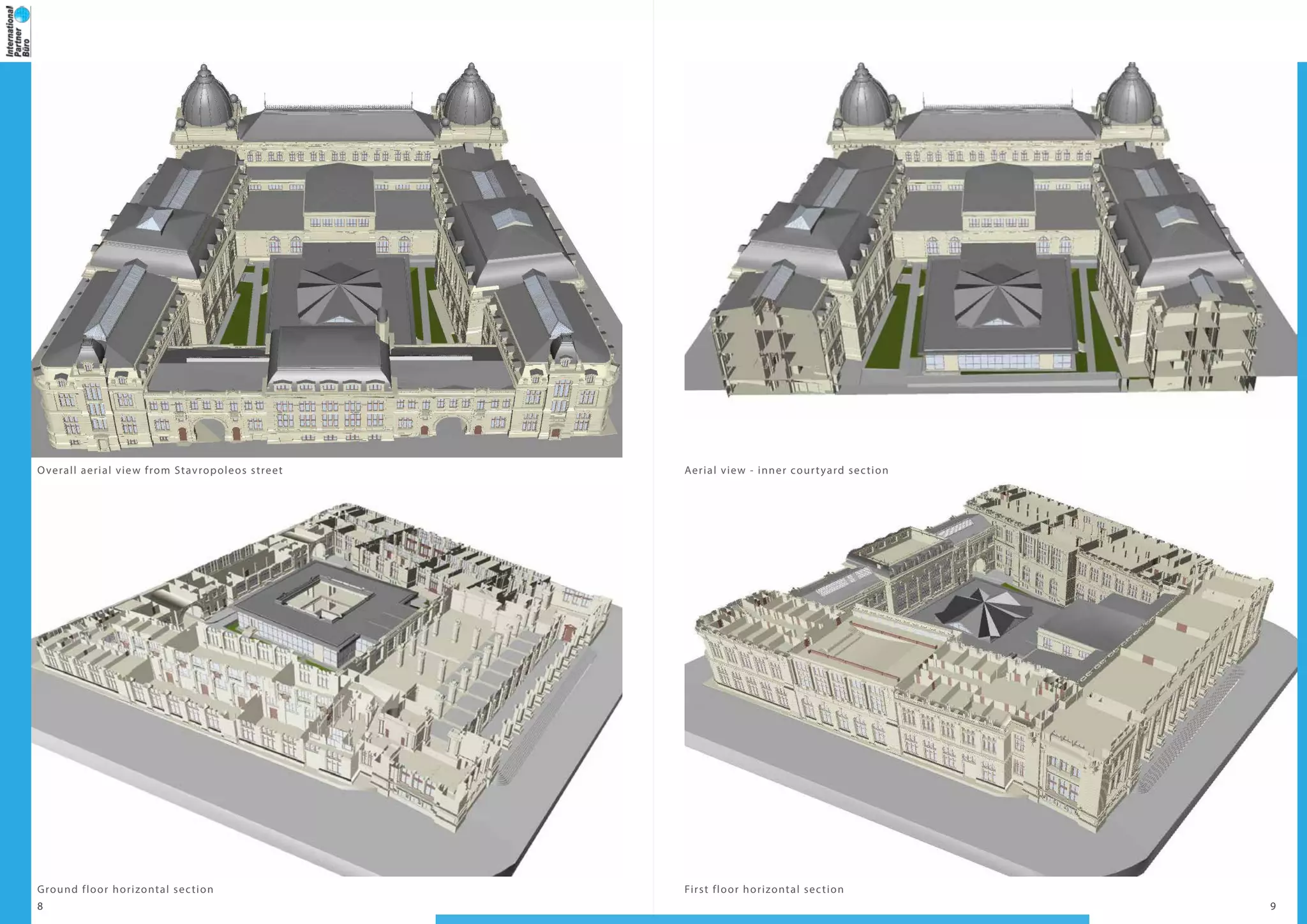
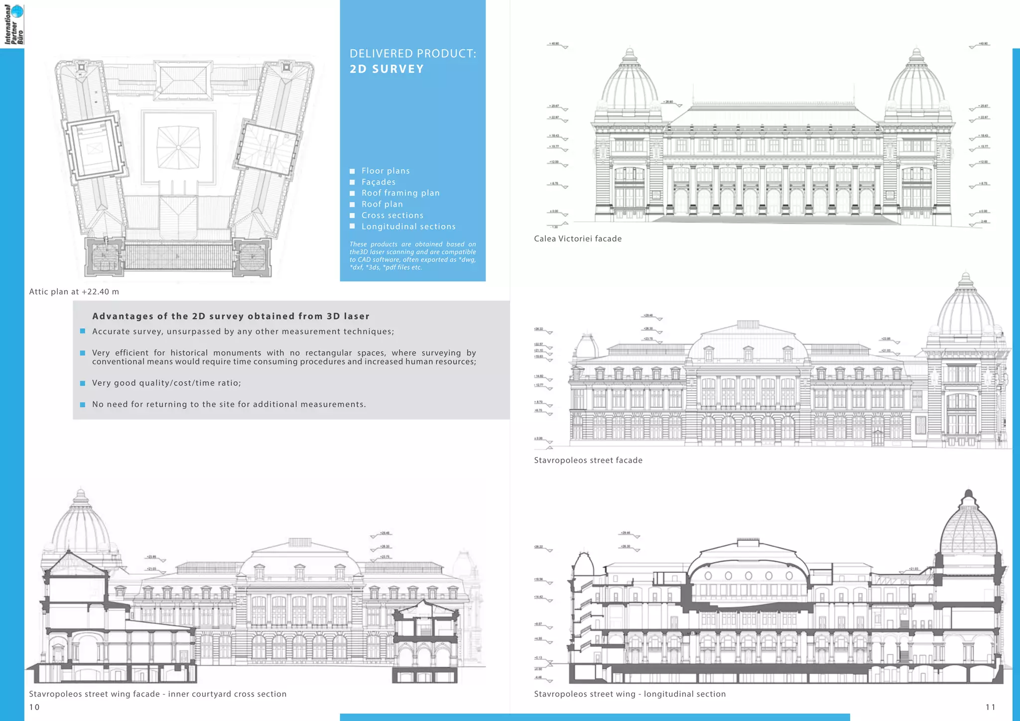
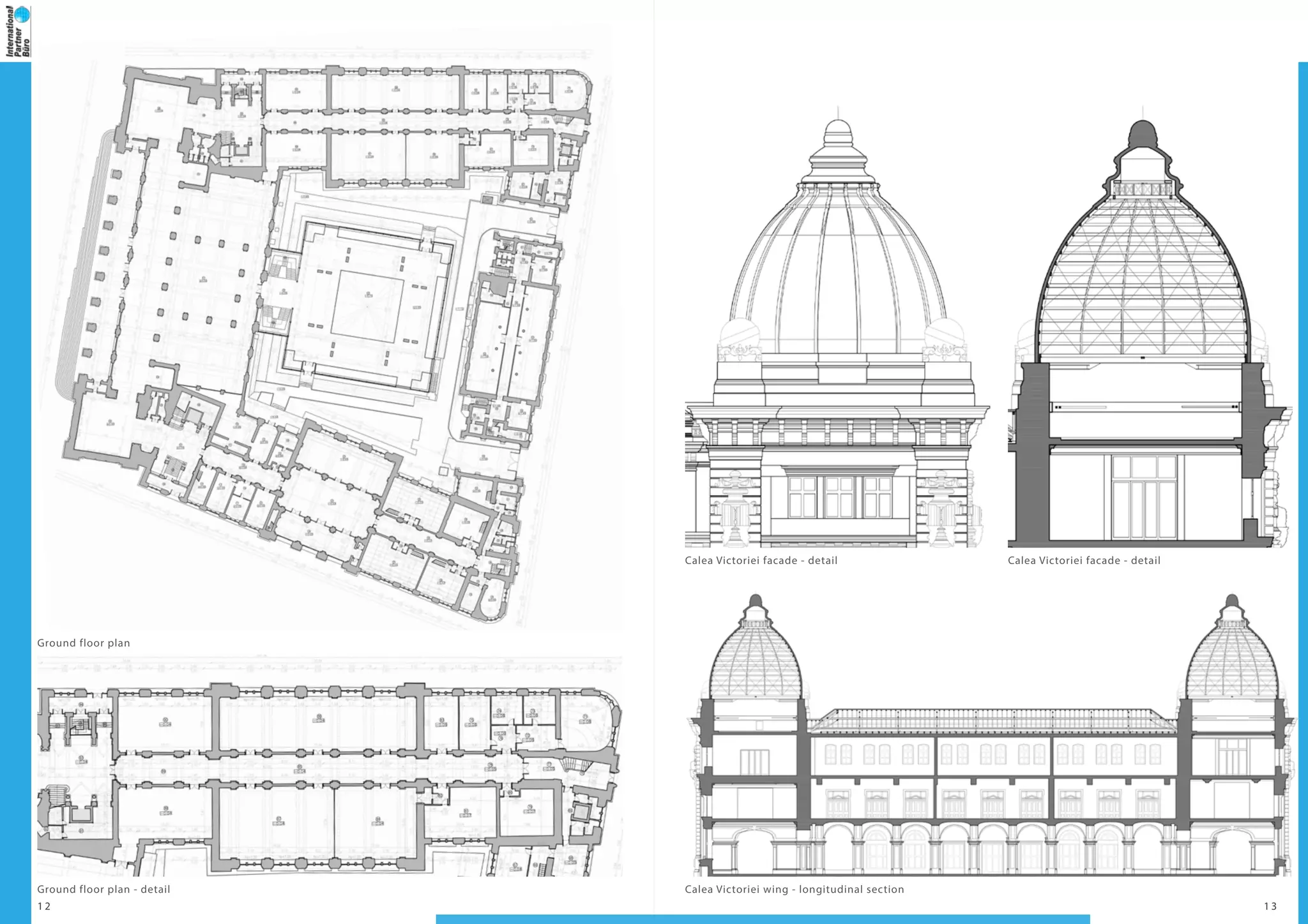
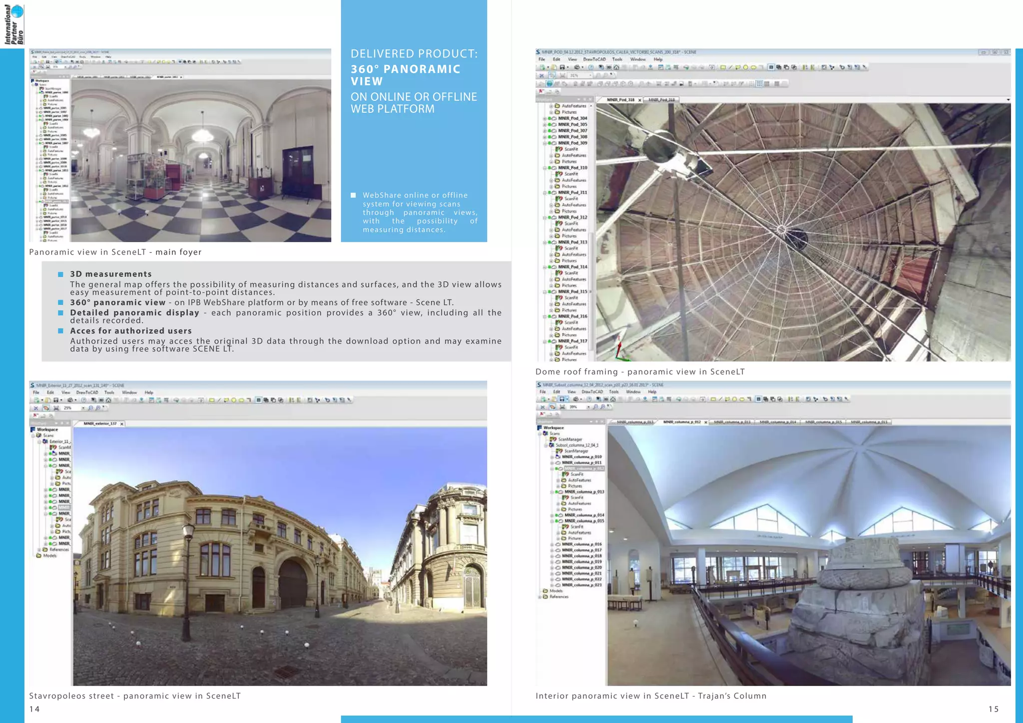
The document summarizes a 3D laser scanning project of the National Museum of Romanian History in Bucharest, Romania. The museum, located in a historic building from the late 19th century, was scanned using laser scanning to create a detailed 3D model and documentation for rehabilitation purposes. Over 2400 scans were taken, producing a point cloud with high accuracy and detail of the building. Products delivered included a 3D model, 2D floor plans and sections, a BIM model, and 360-degree panoramic views for viewing the scans. The laser scanning provided an efficient, accurate, and non-invasive means to digitally document the building.
This document summarizes a 3D laser scanning project of an industrial shed in Romania. Key information collected includes a point cloud, Revit BIM model, and 2D survey drawings. Deliverables include the point cloud, 3D model ready for BIM with interior/exterior details, and 2D floor plans, sections and elevations. 3D laser scanning provides accurate, detailed documentation of existing structures to inform preservation, renovation or new construction.
This document discusses a 3D laser scanning project of the Otetelesanu Manor in Gradinari, Romania. The scanning was conducted to create a detailed documentation of the building's current state to aid in preservation and rehabilitation planning. The scanning produced a 3D point cloud, from which 2D plans, sections, and elevations were extracted. It also generated a 3D model and panoramic views. The document outlines the advantages of laser scanning for heritage documentation and provides examples of the company's past projects involving heritage buildings in Romania and Europe.
AEC Digital Solutions LLC (www.aecdsl.co) is a pioneering Building Information Modelling (BIM) services firm, providing Virtual Design & Construction (VDC) technology services, and global sourcing solutions to leading international architects, engineering and construction firms. AEC's objective is to leverage international best practices and latest advancements in BIM technology, to add value to clients businesses, and help client's save time and money.
3D laser scanning technology allows for the rapid and accurate capture of spatial data in three dimensions. International Partner Buro S.R.L. uses this technology to provide 3D point clouds, models, panoramic views, and other products to clients in industries such as oil and gas. The laser scanning process generates detailed spatial data that can be used for applications like monitoring infrastructure, volume calculations, and facilitating project planning and maintenance.
Design of electrical substation with revit autodeskRosmer Ocando
The document describes the benefits of using Autodesk Revit software to design electrical substations. It allows developing an accurate model from the beginning that facilitates cost estimation, scheduling, and coordination between disciplines. The BIM model in Revit enables calculating quantities of materials, equipment placement and procurement planning, cable and conductor lengths, and structural elements. It can also generate renders, VR simulations, and 2D drawings for construction. Revit provides a collaborative platform for integrated substation design.
This document provides information about Building Information Modeling (BIM) training offered by Jupiter Technologies. BIM is a process of digitally representing a building to contain data about the building's physical and functional characteristics. Jupiter Technologies offers both introductory and advanced BIM training courses lasting 50-100 days using software like Revit, Navisworks, and Dynamo. The training aims to equip students with in-demand BIM skills and knowledge for roles in architecture, engineering, and construction.
3D laser scanning was conducted over 4 days at oil installations in Romania, capturing 20 scans. This generated a detailed 3D point cloud representing the installations. From the point cloud, 3D models of the installations were created and made available both offline through a web platform and online, allowing users to view panoramic images and measure distances. The laser scanning provided an accurate digital copy of the installations for updating plans and facilitating modernization projects.
This company provides professional 3D laser scanning services with a focus on point cloud processing and deliverables such as 3D models, BIM models, and documentation. They have offices in Poland and the UK and work on projects across various industries including industrial sites, offshore installations, architecture, heritage sites, and urban planning. They employ CAD engineers and use software from Bentley, Autodesk, and Leica to process point clouds and generate outputs.
A survey on modeling guidelines for quantity takeoff-oriented BIM-based designAbdoul-Aziz Gansonre
Building Information Modeling (BIM) based quantity takeoff is one of the potentially most
important and profitable applications for BIM.
This presentation explores the subject by presenting a case study that surveys
BIM input/output dynamics for quantity takeoff, examining model behavior when constrained by existing specifications for quantity takeoff, and detailing modeling guidelines that allow the user to extract quantities according to current specifications.
Takeoff specifications should therefore be revised in order to account for BIM's features, and thus minimizing its limitations.
International Partner Buro conducted 3D laser scanning of 21 petrochemical installations in Romania over 7 days. They delivered 3D point clouds and models of the installations that were compatible with CAD software. The point clouds and models allowed accurate measurements and the creation of as-built 3D representations. Panoramic images and an online platform also provided access to the 3D scan data and allowed viewing and measuring from any location.
Here are the key points from the workshop discussion:
- The workshop brought together industry professionals, academics and technology suppliers to discuss adopting BIM Level 2 standards and applying BIM to the transportation and heritage sectors.
- Presenters discussed how applying Lean principles strategically can support BIM implementation. Case studies showed BIM delivering 20% construction savings and 33% whole-life savings on projects.
- The UK government aims to increase construction sector efficiencies through legislation and best practices to lower costs, accelerate delivery, reduce pollution and increase exports by 2025.
- BIM benefits for infrastructure include reduced costs, carbon, time, improved information continuity and asset management, constructability, safety, waste reduction and resource efficiency.
3D laser scanning was used to document oil installations in Romania over the course of a week, capturing 57 scans. The scanning allowed for accurate 3D modeling and measurement of the complex pipe systems and infrastructure in a safe, efficient manner. Products delivered included 3D point clouds, 3D models compatible with engineering software, and an online platform allowing remote viewing and measurement of the scans. The company has extensive experience performing 3D laser scanning for oil and gas infrastructure projects.
3D laser scanning was conducted over 4 days at a petrochemical installation in Romania. 20 scans were performed to create a detailed 3D point cloud and 3D models of the installation. The point cloud and 3D models were delivered to the client and can be viewed online through a web platform, allowing accurate documentation and measurements to support maintenance and design work.
International Partner Buro conducted 3D laser scanning of oil installations in Romania over the course of a week, capturing 101 scans. They produced 3D point clouds and models of the installations that were compatible with CAD software. They also created 360-degree panoramic views and an online platform for clients to view the scans, measurements, and 3D data. International Partner Buro has extensive experience performing 3D laser scans of oil and gas infrastructure for documentation, inspection, and facility management.
Unmanned aerial vehicles UAVs for the Construction IndustrySue McKinney
The potential for using UAVs within the construction and civil engineering industry is significant yet their use is currently relatively limited. The main reason behind this is a lack of awareness of their potential and the range of benefits that they can bring, even though, right through from planning to final construction, nearly every stage of the engineering process can benefit from the use of a UAV.
The document discusses using laser scanning point clouds to create Building Information Models (BIM). It describes how point clouds collected via laser scanning can be processed and used to efficiently generate 3D digital models of objects. The models integrate spatial data with semantic information like material properties. BIM allows all project stakeholders to access shared information across design, construction and management. Laser scanning provides accurate spatial data to complete the BIM workflow and plays an important role in construction projects. The document presents a case study of a church scanning project and processing the point clouds in Revit software to generate object-oriented BIM models for documentation and future applications.
R2 d introduction 3d laser scanning infrastructure 2014Steven Couwels
Real to Desk provides 3D laser scanning and spatial documentation services. They collect accurate 3D data using laser scanning to create as-built models of structures. This data can then be converted into 3D CAD and BIM models, 2D drawings, and other deliverables. Their services benefit clients by capturing details faster and more completely than traditional surveying, while being cost-effective. Real to Desk works on projects like monitoring construction, facility management, and comparing as-built structures to original designs.
Presentation to NH Arch - Parametric Modelling and Evolutionary AnalysisNathan Luke
Parametric modeling and evolutionary analysis allow for rapid iteration and optimization of designs. Parameters can define geometric properties and be linked to analysis to automatically evaluate designs. This allows exploration of many design options to find the best solution. Examples shown include a snowflake structure where the dome geometry was optimized through structural analysis in Grasshopper. A stadium project demonstrated using parameters to accurately place members and apply rotations based on building planes. Key benefits are closer integration of architecture and structure, increased options evaluation, and efficient form finding.
Use of CityGML standard in the context of Smart Cityi-SCOPE Project
The document discusses CityGML, an open standard for storing and exchanging 3D city and landscape models. CityGML allows for the modeling of 3D urban objects along with their geometrical, topological, semantic and appearance properties. It supports 5 levels of detail and can represent buildings, bridges, tunnels, vegetation, water bodies and other features. The document also discusses how CityGML can be used for applications in smart cities, including modeling for improved accessibility, energy dispersion modeling, and noise mapping/simulation.
The document discusses a 3D laser scanning survey of the Eglise d'Hampigny church located in Hampigny, France. The survey was conducted to create 2D plans, orthorectified images, a 3D model, and point cloud of the church to aid in planning its restoration and preservation. The laser scanning method provided accurate documentation of the church's condition and structural details to architects more efficiently than conventional surveying techniques. Products of the survey included 2D floor plans, elevations, sections, and orthorectified images draped over the 3D model and point cloud for analysis and restoration work.
International Partner Buro conducted 3D laser scanning of petrochemical installations in Romania over 10 days, capturing 80 scans. The scanning provided accurate 3D point clouds and models of the installations in formats compatible with CAD and other software. Web-based platforms allow viewing full panoramic scans and measuring distances online or offline. The portfolio lists numerous oil and gas facilities previously scanned.
A 3D laser scanning project was conducted over 1 week in Romania to create 3D models and point clouds of petrochemical installations. 95 scans were taken and products delivered included 3D point clouds, models, and 360 degree panoramic views. The data can be accessed online or offline and is compatible with various software programs. International Partner Buro provides 3D laser scanning and surveying services globally.
This document discusses 3D laser scanning services provided by International Partner Buro S.R.L. for oil installations in Romania. The company uses 3D laser scanning to create 3D point clouds and models of oil refineries, which are then used to generate as-built documentation. Key deliverables include 3D point clouds, 3D models, 360-degree panoramic views, and an online/offline platform for viewing scans. The scanning provides accurate documentation of installations in a safer and more efficient manner than traditional methods.
3D laser scanners are used to capture point clouds of structures which are then modeled in BIM software like Revit. This allows the accurate recreation of as-built models for renovation, retrofit, and facilities management purposes. A case study describes a hospital that was laser scanned and the data used to create a Revit BIM model for refurbishment planning without multiple site visits.
FULL PROJECT MANAGEMENT AND CONSULTANCY
- Single-point responsability;
- Improved schedule and performance;
- Cost control and value engineering;
- Enhanced client risk management;
- Coordination of global participation.
3D LASER SCANNING
- Consistent as-built documentation for CAD specifications of the plant layout;
- Monitoring installation behavior over time;
- Prefabrication purposes;
- Deformation analysis and tridimensional positioning.
CLASH DETECTION AND REPORTING
- Clash / Inter ference check between existing conditions and new designed elements.
DIMENSION CONTROL
- Dimensional assessments for installations, equipments and structures;
- Correspondence check between CAD project and point clouds;
- Tank / vessel volumetric information;
3D MODELLING
- Complete 3D CAD models based on 3D point clouds.
2D DRAWINGS
- P&IDs, isometrics, sections, elevations, plans.
DATA CONVERSION
- Point clouds conversion to various data formats to meet client ’s requirements.
This document summarizes a 3D laser scan survey of two sites in Belfast City Centre for a new student accommodation development. At the first site, a 3D survey was conducted of the surrounding 3 city blocks to capture all adjacent buildings for construction of an accurate 3D model. At the second smaller site, a survey of 1 block was done. A total of 40 scans were taken over 3 days using a Leica Scan Station C10 laser scanner. The scans were combined and exported to modeling software to create 3D polyline window openings for right of light analysis, with the 3D models and window lines delivered within 5 days.
Magnasoft is an international geospatial and 3D laser scanning services company that leverages technology, domain knowledge, and work processes to deliver high quality data to clients worldwide. It has over 350 global clients, 600 associates, and centers of excellence in 65+ countries. Magnasoft offers as-built 3D modeling services for structures, equipment, HVAC, piping, electrical, and instrumentation using software like AutoCAD, Revit, CADWorx, PDMS, and Microstation. It captures laser scan and photographic data and creates 3D models, drawings, and other deliverables for industries like oil and gas, process, shipbuilding, airports and more.
We are a professional surveying company specializing in 3D laser scanning with offices in the UK and Poland. We have over 30 CAD engineers and process laser scan data using software like Bentley and AutoDesk to produce deliverables such as 3D models, as-built documentation, and clash detection reports. Our services are applicable to architecture, industrial sites, offshore installations, and urban planning projects.
The document is a presentation by Naksha Tech Pvt. Ltd. on 3D modeling. It discusses laser scanning as a process to capture 3D surface data of objects using a laser and camera. It then outlines Naksha Tech's 3D modeling workflow including pre-processing captured point cloud data, producing 3D models, quality control checks, and output delivery in formats like AutoCAD, Revit, and Cyclone. Examples of 3D modeling projects are also shown for buildings, industrial facilities, oil and gas plants, and more.
Laser scanning constitutes the deflection of laser beams. 3D Scanning involves the process of analyzing real-world objects for collecting data of shapes and appearance. The collected data is then used for constructing digital 3D Models, consisting of a polygon mesh or point cloud of geometric samples on the surface of the object.
https://www.tejjy.com/our-services/bim-services/3d-laser-scanning-services/
Three-dimensional (3D) laser scanning
uses light detection and ranging (LIDAR)
measurement techniques to quickly and
accurately collect data on the size and shape
of an object or environment. Through the
years, the cost to purchase and operate
stationary and mobile scanning has decreased
and is now changing the way 3D data is
captured and interpreted.
The Poster of Application of terrestrial 3D laser scanning in building inform...Martin Ma
The document discusses the methodology used in a project applying terrestrial 3D laser scanning in building information modeling (BIM). It describes using a Leica Scan Station C10 laser scanner to collect point cloud data of a target building. Cyclone software was then used to combine the point cloud data with a 3D BIM. Autodesk Revit, a BIM software, was used to create 3D models from the point cloud data. The project involved laser scanning a ship garage to collect point cloud data, processing the raw data in Cyclone, and creating a 3D BIM of the garage in Revit based on the point cloud.
FULL PROJECT MANAGEMENT AND CONSULTANCY
- Single-point responsibility;
- Improved schedule and performance;
- Cost control and value engineering;
- Enhanced client risk management;
- Coordination of global participation.
3D LASER SCANNING
- Consistent as-built documentation for CAD specifications of the plant layout;
- Monitoring installation behavior over time;
- Prefabrication purposes;
- Deformation analysis and 3D positioning.
CLASH DETECTION AND REPORTING
- Clash / Interference check between existing conditions and new designed elements.
DIMENSION CONTROL
- Dimensional assessments for installations, equipment's and structures;
- Correspondence check between CAD project and point clouds;
- Tank / vessel volumetric information;
3D MODELLING
- Complete 3D CAD models based on 3D point clouds.
2D DRAWINGS
- P&IDs, isometrics, sections, elevations, plans.
DATA CONVERSION
- Point clouds conversion to various data formats to meet client ’s requirements.
Do you want to get a quick measurement? Seek 3D Laser Scanning for quick data capture, making it possible to record millions of data points in seconds, reducing risk in the long run. For dangerous or difficult-to-reach regions, the 3D scanner's remote documentation is perfect. To get more information about laser 3D scanning or implement laser scanning 3D services, contact the top BIM consultants in USA at 240-899-7711 or info@topbimcompany.com. Take a look at the PPT for more details.
SJ Geomatics offers professional surveying services including GPS surveys, boundary surveys, topographical surveys, building surveys, underground utility detection, 3D laser scanning, setting out services and monitoring, 3D modeling, and volumetric calculations. The company uses state-of-the-art equipment to provide accurate surveying services to architects, developers, and others in the construction industry.
Coastway SCAN to BIM Presentation may 25th citaCoastway
The document summarizes a presentation given at the Construction IT Alliance 22nd Members Meeting on using building information modelling (BIM) systems with laser scanning to create interactive facility management capabilities. It provides examples of how laser scans can be used to generate accurate building information models, extract model elements, and perform analyses like thermal modeling. Attendees learned about Coastway Ltd.'s laser scanning and BIM services and the advantages of working with laser scan point cloud data.
1. NATIONAL MUSEUM OF ROMANIAN HISTORY
3D LASER SCANNING | eBIM | 3D MODEL | 2D SURVEY
B u c h a r e s t , R o m a n i a
2. 1
3D POINT CLOUD
2D SURVEY
3D MODEL
eBIM MODEL
360° PANORAMIC VIEW
ONLINE OR OFFLINE WEB PLATFORM
2
4
10
6
14
N AT I O N A L M U S E U M O F
R O M A N I A N H I S T O R Y
LOCATION:
Calea Victoriei, no. 12
Bucharest, Romania
GROSS BUILDING AREA:
23.550 sqm
NUMBER OF SCANS:
2474 scans
Exterior view of the Museum
Faster data collection, as compared to conventional methods;
Very low risk of occupational accidents;
Non-invasive method of data collection;
Full, authentic and accurate 3D copy of reality, unsurpassed by any other means or method
of measurement;
2D and 3D documentation provided to architects and structural engineers;
Conversion of data into 2D and 3D models compatible with all CAD software;
Structural details - complex documentation due to accuracy and large amount of data collected
through 3D laser scanning;
Restoration of complex architectural elements;
Conversion of 3D laser scans in digital orthophotos;
Perfect alternative to conventional measurement methods for historic monuments.
3D Laser Scanning
Project purpose: eBIM | 3D Model | 2D Survey
The National Museum of Romanian History is located in the historic
building also known as “The Post Palace”. Designed by the architect
Alexandru Savulescu in neoclassical style with German influences, the
edifice was built at the end of the 19th century.
The Post Palace becomes headquarters of the National Museum of
Romanian History in 1972 and is nowadays a historic monument. The
structure of the building was seriously damaged by the 1940 and 1977
earthquakes and is currently undergoing a rehabilitation process.
Therefore, it was decided that a detailed documentation of the building’s
current state was needed and the survey was carried out using the 3D
laser scanning method.
Advantages of the survey obtained through this innovative measurement technique,
supporting the rehabilitation project of the National Museum of Romanian History are:
International Partner Buro S.R.L.
Office:
www.ipartner.ro
office@ipartner.ro
+4 - 0722 998 663
Bucharest, Romania
PhD. Dipl.-Eng. Marian RăDOI
CEO - International Partner Buro S.R.L.
3D Laser Scanning & Surveying specialist
Member of ICOMOS Romania
+ 4 - 0766 462 766
marian.radoi@ipartner.ro
3. 2 3
DELIVERED PRODUCT:
eBIM MODEL
eBIM Model based on the
3D point cloud
eBim based on the 2D
survey (CAD to BIM)
These products are obtained based on the
3D laser scanning and are compatible to
CAD software, often exported as*rvt, *fbx,
*xml, *dwg, *dxf, *pdf files etc.
What is BIM | eBIM ?
Building Information Modelling (BIM) is the process of building a 3D model which contains
parametric information about each element of a construction, including time and cost data. The
model can be used to make decisions during the whole life cycle of a building, from the design
stage to maintenance, preservation and rehabilitation works.
Existing Building Information (eBIM) provides a detailed and accurate 3D model of the current
stage of a construction made by processing the point cloud obtained from 3D laser scanning.
Detail level included in the 3D eBIM model:
- Visible structural elements (columns, beams, slabs);
- Exterior elements: exterior walls, roof;
- Partition elements: interior walls;
- Stairs, windows, doors;
- Sanitary fittings;
- Decorative architectural elements.
eBIM models can be generated in BIM software such as Autodesk Revit, Graphisoft ArchiCAD, RhinoBIM etc.
Advantages of the 3D eBIM model obtained from the 3D laser scanning:
Performing the 3D model faster, as compared to obtaining the model starting from the 2D survey;
High accuracy of the 3D model, as it is achieved by processing the point cloud obtained from the
3D laser scanning;
Complete documentation of the current state of the scanned building;
High level of detail of complex architectural, structural and installation elements;
The possibility of achieving accurate data about each building’s element, due to the parametric
3D eBIM model;
Full documentation provided to contractors, architects and engineers, enabling maintenance,
preservation and rehabilitation works.
3D LASER SCANNING
- larger amount of data
collected in a shorter period
of time;
- very low risk of occupational
accidents;
- non-invasive method of
data collection.
3D POINT CLOUD
- full and authentic 3D copy of
reality;
- the starting point for a complete
documentation of the building’s
current state;
- accuracy and high detail level of
the scanned object.
eBIM Model
- the delivered project is an
intelligent parametric 3D model;
- obtaining a detailed and accurate
model in a short time;
- enables a more efficient and
collaborative interaction between
the client, architect and engineer. Processing the 3D point cloud in Autodesk Revit - roof plan
Processing the 3D point cloud in Autodesk Revit - Calea Victoriei facade
Planning
eBIM
Analysis
DesignDemolition
Construction
DocumentationMaintenance
Rehabilitation
4. 4 5
3D point cloud - aerial view of the Museum
3D point cloud - cross section of the inner courtyard
3D point cloud - Stavropoleos street facade
DELIVERED PRODUCT:
3D POINT CLOUD
3D point cloud animations;
Simulations with insertion of a
proposed intervention on the
existing site achieved from the
3D point cloud;
Point cloud viewing system,
in free software, with the
possibility of measuring
distances and exporting point
clouds.
Advantages of the point clouds obtained from 3D laser scanning:
Point clouds are a full, authentic and accurate copy of reality, which cannont be obtained by any
other means or method of measurement;
The current state of the historical building can be thoroughly documented, based on the 3D
point cloud;
3D point clouds allow exact measurements of distances and areas and they represent the starting
point for the 2D survey and the 3D model.
3D point cloud - longitudinal section through Calea Victoriei wing
3D point cloud - Postei street facade
3D point cloud - longitudinal section through Postei street wing
5. 6 7
DELIVERED PRODUCT:
3D MODEL
Exterior 3D volume
Interior 3D model
Roof framing 3D model
These products are obtained based on
the3D laser scanning and are compatible
to CAD software, often exported as *dwg,
*dxf, *3ds, *pdf files etc.
Advantages of the 3D model obtained from 3D laser scanning:
Allows measuring and viewing all architectural elements, even if they may not be
included in the 2D survey;
The 3D model may be used for volume measurements;
The roof framing model is an accurate 3D copy of the roof ’s framework, allowing structural
calculations for consolidation or addition works;
May be used for further editing in order to obtain realistic visualizations.
3D model - view from Calea Victoriei Calea Victoriei wing - 3D model section
Calea Victoriei wing - 3D roof framing
3D model - main foyer view Franceza street roof framing - 3D model detail
6. 8 9
Ground floor horizontal section First floor horizontal section
Aerial view - inner courtyard sectionOverall aerial view from Stavropoleos street
7. 1 0 1 1
These products are obtained based on
the3D laser scanning and are compatible
to CAD software, often exported as *dwg,
*dxf, *3ds, *pdf files etc.
DELIVERED PRODUCT:
2D SURVEY
Floor plans
Façades
Roof framing plan
Roof plan
Cross sections
Longitudinal sections
Advantages of the 2D survey obtained from 3D laser
Accurate survey, unsurpassed by any other measurement techniques;
Very efficient for historical monuments with no rectangular spaces, where surveying by
conventional means would require time consuming procedures and increased human resources;
Very good quality/cost/time ratio;
No need for returning to the site for additional measurements.
Attic plan at +22.40 m
Stavropoleos street wing facade - inner courtyard cross section Stavropoleos street wing - longitudinal section
Stavropoleos street facade
Calea Victoriei facade
9. 1 4 1 5
3D measurements
The general map offers the possibility of measuring distances and surfaces, and the 3D view allows
easy measurement of point-to-point distances.
360° panoramic view - on IPB WebShare platform or by means of free software - Scene LT.
Detailed panoramic display - each panoramic position provides a 360° view, including all the
details recorded.
Acces for authorized users
Authorized users may acces the original 3D data through the download option and may examine
data by using free software SCENE LT.
Interior panoramic view in SceneLT - Trajan’s Column
Dome roof framing - panoramic view in SceneLT
Panoramic view in SceneLT - main foyer
Stavropoleos street - panoramic view in SceneLT
DELIVERED PRODUCT:
360° PANORAMIC
VIEW
ON ONLINE OR OFFLINE
WEB PLATFORM
WebShare online or offline
system for viewing scans
through panoramic views,
with the possibility of
measuring distances.
10. 1 6
Planning
DesignDemolition
DocumentationMaintenance
Analysis
ConstructionRehabilitation
eBIM
3D LASER SCANNING POINT CLOUD eBIM model
EFFICIENCY AND ACCURACY IN SURVEYING EXISTING BUILDINGS
C O N T A C T
Y O U R N U M B E R 1 O P T I O N
I N 3 D L A S E R S C A N N I N G
PhD Dipl.-Eng. Marian RADOI
CEO - International Partner Buro S.R.L.
3D Laser Scanning & Survey specialist
Member of ICOMOS Romania
International Council of Monuments and Sites
+ 4 - 0766 462 766
marian.radoi@ipartner.ro
OFFICE:
www.ipartner.ro
office@ipartner.ro
+ 4 - 0722 998 663
/ScanareLaser3D
/ipartner.ro
Bucharest, Romania
* International Partner Buro provides 3D laser scanning
services globally.
11. 3DLASERSCANNING
UAVFOTOGRAMMETRY
S U R V E Y
BIM
G I S
ARCHITECTURAL SURVEY
CONSTRUCTION SURVEY
ENGINEERING SURVEY
LAND SURVEY
3DBUILDINGMODELLLING
3DTERRAINMODELLING
2DDRAWINGS
CADASTRE
LANDREGISTRATION
www.ipartner.ro