The document provides an overview of the geological and mining potential of Ecuador. It discusses the country's six main geo-structural domains from west to east, including the fore arc basin of the coast, western cordillera, inter-andean graven, real or central cordillera, eastern subandean zone, and back arc basin of Iquitos. Each domain hosts various mineral deposit types with potential for gold, copper, iron, and other metals. Major mining districts in Ecuador include Azuay, La Plata, Imbaoeste, Alao Paute, and Zamora, which contain porphyry copper, epithermal gold, and volcanic massive sulfide deposits.
Origin and Abundance of elements in the Solar system and in the Earth and its...AkshayRaut51
Definition of Elements and atom
Origin of Universe
Theories of origin of Solar system and Earth
Chemical Composition of Planets
Chemical Composition of Earth
Chemical composition of Meteorites
Abundance of Elements
Information about these fluids is an invaluable aid in mineral exploration.
Conventional academic methods of analysing fluid inclusions are too slow and tedious to be of practical application in typical mineral exploration activities.
However, the academic data from numerous studies does show that CO2 is an exceptionally important indicator when exploring for most types of gold deposit.
Because the baro-acoustic decrepitation method is a rapid and reliable method to measure CO2 contents in fluids, it can be used to study a spatial array of data and it is an invaluable and practical exploration method.
Measurements of temperatures of fluid inclusions does not usually help in mineral exploration as hydrothermal minerals deposit over a wide temperature range and there is no specific temperature which is indicative of mineralisation. However, if temperatures are available on a large spatial array of samples, then temperature trends may be a useful exploration method to find the hottest part of the system, which is presumably the location of the best economic mineralisation. Baro-acoustic decrepitation is the most practical method to determine temperatures of the large numbers of samples required.
Salinities of fluid inclusions are of limited use in exploration and are difficult to measure. However, they can be used to recognise intrusion related hydrothermal systems.
The name ophiolite derived from Greek root which means
Ophio : snake or serpent Litho : Stone
The green colour, structure and texture of sheared ultramafic rocks is similar to some serpents
Economically :
Massive Sulphide
It founded within pillow lava most of massive Sulphide associated in ophiolites have well developed Gossans (bright colored iron oxide, hydroxides, and sulfides) which is very rich in gold.
Chromite
Stratiform (be tabular or pencil shape) or podiform (irregular shape) within ultra-mafic rocks
These deposits are developed on serpentinite peridotite
Laterites (nickel and iron)
Asbestos
Talc
Magenesite
ophiolite sequence :
Sediments
Pillow Lavas
Dykes
Gabbros
Layered Gabbro
Layered Peridotite
Upper mantle
Komattite
Named after the Komati River in South Africa.
first described by Morris and Richard (twins) for ultramafic units in the Barberton Greenstone belt of South Africa.
Mostly of komatiite are Archean age
distributed in the Archaean shield areas.
Also a few are Proterozoic and Phanerozoic.
In all ages komatiites are highly magnesium.
Mostly a volcanic rock; occasionally intrusive.
Mafic rocks were identified as extrusive because of their volcanic textures and structures, and they seem to have been accepted as a normal component of Archean volcanic successions, Abitibi in Canada.
The ultramafic rocks were interpreted as intrusive which are founded as sills and dykes, Barberton in South Africa.
Spinifex texture-typical of Komatiites:
Texture of Ore Minerals; Importance of Studying Textures; Individual Grains Properties; Filling of voids; Texture Types; Genetically differentiated between Texture types; Secondary textures from replacement; Hypogene Texture; Supergene Texture; Primary texture formed from Melts; Primary texture of open-space deposition; Secondary textures from cooling; Secondary textures from deformation; TEXTURES OF ECONOMIC ORE DEPOSITS; Textures of Magmatic ores; Cumulus textures; Intergranular or intercumulus textures; Exsolution textures; Textures of hydrothermal ore deposits and skarns; Replacement textures; Open space filling textures; Textures characteristic of surfacial or near surface environments and processes; Criteria for identifying replacement textures; Vein and Veining have different Nature Features
In the Environmental Sciences Isotope geochemistry has become an essential tool for the
environmental sciences, providing clearly defined tracers of sources, quantitative information
on mixing, identification of physical and chemical processes, and information on the rates of
environmental processes. Clearly, this tool will continue to be important in all aspects of the
field, including studies of contamination, resource management, climate change, bio-
geochemistry, exploration geochemistry, archaeology, and ecology. In addition to further
utilization of established methods, new applications will continue to be developed.
Plate tectonics, like crustal evolution, provides a basis for understanding the distribution and origin of mineral and energy deposits. Different types of ores are characterized by distinct geological environment and tectonic settings.
Minerals are formed by changes in chemical energy in systems which contain one fluid or vapor phase. In nature, minerals are formed by crystallisation or precipitation from concentrated solutions. These solutions are called as ore-bearing fluids. Ore-bearing fluids are characterised by high concentration of certain metallic or other elements.
Fluids are the most effective agents for the transport of material in the mantle and the Earth's crust.
This is my presentation on the tectonic control of sediments.
It includes the effects of tectonics either direct or indirect on sediments and sedimentation.
Sedimentation along various plate boundaries.
Few examples as evidence from Pakistan (the Siwalik Group) and Argentina (Fiambala Basin)
Petrographic evaluation of rocks around Arikya and its environs, North Centra...Premier Publishers
The study area covers Arikiya and parts of Wayopini in Lafia Local Government Area of Nassarawa State, situated in central Nigeria. This falls within the Basement Complex of central Nigeria that forms part of the Upper Proterozoic mobile belt extending from Algeria across the Sahara into Nigeria, Benin and the Cameroon. The area consists of gneisses, granite gneisses, migmatites and Porphyroblastic gneiss. Dolerite dyke and Pegmatite form intrusions into the host rocks. The major rock forming minerals are plagioclase, orthoclase, quartz and biotite. The major structures includes joints, foliations, quartz vein, fold and fault, Predominant structural trends include the NE-SW and NW-SE with minor E-W and N-S structural trends which are in agreement with the general trend of structures in the Basement Complex. Mineral resource potential of the study area include feldspar and mica from the gneiss and pegmatites as well as alluvial garnets, columbites, tantalite, and cassiterite (derived from the pegmatites) as evidenced from mining activities along river channels in the entire area.
Geological and Geochemical Characterization of the Neoproterozoic Derudieb Me...Premier Publishers
The meta- volcano - sedimentary sequences in the northern part of the Red Sea Hills comprise a sequence of metamorphosed rocks at low green schist facies of metamorphism consisting of lava flows, tuffs to breccias and agglomerates range in composition from basalts and andesites to rhyolites. Geologically the meta volcano sedimentary sequences is divided into metavolcanic rocks and metasediments. The metavolcanic rocks range in composition from mafic to felsic. The metasediments are represented by banded schist, quartzite and marble. The samples collected for study lie within the field of sub-alkaline rocks except one mafic volcanic sample, which plot near the boundary in the alkaline field and thus follow a transitional tholeiitic to calc-alkaline trend (increasing FeO* relative to MgO). The behavior of the large ion lithophile element (LILE) in the studied metavolcanics confirms the early fractionation of plagioclase. These rocks display negative Nb anomalies, suggesting that the melt source was modified by subduction-related fluids. Tectonically all felsic samples fall in the field of volcanic arc granitoids whereas the mafic units plot firmly within the plate margin field.
Tectonic Processes and Metallogeny along the Tethyan Mountain Ranges of the M...MYO AUNG Myanmar
https://www.researchgate.net/publication/309130798_Tectonic_Processes_and_Metallogeny_along_the_Tethyan_Mountain_Ranges_of_the_Middle_East_and_South_Asia_Oman_Himalaya_Karakoram_Tibet_Myanmar_Thailand_Malaysia
The genesis of mineral deposits has been widely linked to speci c tectonic settings, but has less frequently been linked to tectonic processes. Understanding processes of oceanic and continental collision tectonics is crucial to understanding key factors leading to the genesis of magmatic-, metamorphic-, hydrothermal-, and sedimentary-related mineral deposits. Geologic studies of most ore deposits typically focus on the nal stages of concentration and emplacement. The ultimate source (mantle, lower crust, upper crust) of mineral deposits in many cases remains more cryptic. Uniquely, along the Tethyan collision zones of Asia, every stage of the conver- gence process can be studied from the initial oceanic settings where ophiolite complexes were formed, through subduction zone and island-arc settings with ultrahigh- to high-pressure metamorphism, to the continental col- lision settings of the Himalaya, and advanced, long-lived collisional settings such as Afghanistan, the Karakoram Ranges, and the Tibetan plateau. The India-Asia collision closed the intervening Neotethys ocean at ~50 Ma and resulted in the formation of the Himalayan mountain ranges, and increased crustal thickening, metamor- phism, deformation, and uplift of the Karakoram-Hindu Kush ranges, Tibetan plateau, and older collision zones across central Asia. Metallogenesis in oceanic crust (hydrothermal Cu-Au; Fe, Mn nodules) and mantle (Cr, Ni, Pt) can be deduced from ophiolite complexes preserved around the Arabia/India-Asia collision (Oman, Ladakh, South Tibet, Myanmar, Andaman Islands). Tectonic-metallogenic processes in island arcs and ancient subduc- tion complexes (VMS Cu-Zn-Pb) can be deduced from studies in the Dras-Kohistan arc (Pakistan) and the various arc complexes along the Myanmar-Andaman segment of the collision zone. Metallogenesis of Andean- type margins (Cu-Au-Mo porphyry; epithermal Au-Ag) can be seen along the Jurassic-Eocene Transhimalayan ranges of Pakistan, Ladakh, South Tibet, and Myanmar. Large porphyry Cu deposits in Tibet are related to both precollisional calc-alkaline granites and postcollisional alkaline adakite-like intrusions. Metallogenesis of continent-continent collision zones is prominent along the Myanmar-Thailand-Malaysia Sn-W granite belts, but less common along the Himalaya. The Mogok metamorphic belt of Myanmar is known for its gemstones associated with regional high-temperature metamorphism (ruby, spinel, sapphire, etc). In Myanmar it is likely that extensive alkaline magmatism has contributed extra heat during the formation of high-temperature meta- morphism. This paper attempts to link metallogeny of the Himalaya-Karakoram-Tibet and Myanmar collision zone to tectonic processes derived from multidisciplinary geologic studies.
La Arena and Alizar are porphyry-type Cu-Au-(Mo) deposits with associated Calaorco and Vanessa highsulfidation
epithermal mineralizations, respectively. In this study, we conducted multiple conventional
geochronologic analyses on samples from La Arena district, with the objective to obtain precise a temporal
relationship among porphyry emplacement, hydrothermal alterations, cooling, exhumation history and preservation,
together with published age data for the district.
A precursor quartz–diorite pluton and a late–mineral andesite porphyry bracketed the mineralization in the La
Arena and Alizar porphyry deposits. Zircon U-Pb dating of these intrusive rocks display markedly concordant
ages, with emplacement beginning and ending at 26.50 ± 0.23 to 25.36 ± 0.07 Ma at La Arena, and at 26.47 ±
0.08 to 25.30 ± 0.07 Ma at Alizar. 40Ar/39Ar chronologic data for hydrothermal biotite from the potassic zone
ranges from 25.97 ± 0.16 to 25.73 ± 0.16 Ma in the Alizar, and hypogene alunite from the advanced argillic
alteration yield an age of 25.66 ± 0.15 Ma in the Vanessa. The weighted mean apatite (U–Th)/He ages of the
porphyry intrusions of the La Arena and Alizar range from 24.26 ± 0.56 to 23.42 ± 0.37 Ma.
These geochronologic data reveal that the porphyry systems were emplaced intermittently for at least 1.2 m.y.
during the late Oligocene (26.5 – 25.3 Ma). The porphyry intrusions would have been uplifted from its depth of
formation at ~ 2 km suggested by telescoped and a short time period (0.07 m.y.; 40Ar/39Ar ages) between
porphyries and associated high-sulfidation epithermal events. The cooling history from zircon crystallization at
800 ◦C to thermal collapse at 75 ◦C (apatite helium close temperature) lasted ~ 2.5 m.y. in the ore-systems. The
thermal collapse occurred coeval with the Inca IV orogeny (~24 Ma), period of rapid uplift and exhumation in
northern Peru (0.24 km/m.y.; (U-Th)/He age-elevation spectrum). If exhumation continued at the rate of 0.24
km/m.y. unroof of the ore-deposits lasted 5 m.y. (24–19 Ma). Since their exposure at ~ 19 Ma, these ore deposits
were subjected to weathering and oxidation during 2.12 m.y. It is thus estimated that approximately 500-m
thickness of materials have been removed from the Alizar and La Arena during uplift and erosion, including a
large volume of ore. Subsequent volcanic activity occurred during the Quechua I orogeny (~17 Ma) at ca. 16.88
Ma, leading to burial and partially preservation of these ore deposits.
Preliminary Studies of the Litho-Structural Evolution of Areas Around Obudu N...IJRESJOURNAL
ABSTRACT: Rocks underlying the northeastern sector of Obudu area forms part of the Bamenda massif which is a westward extension of the Precambrian terrains of Cameroon into southeastern Nigeria. These rocks are frequently found in the basement complex of Nigeria and include the migmatitic gneiss as the early metamorphic tectonites constituting over 60% of the outcropping rocks in the study area. The basement rock of the study area comprised of the migmatite gneiss and biotite-hornblende garnetiferous gneiss as well as the porphyroblastic gneiss and granite gneiss which formed the basement intruded by the Older granites (Pan-African granitoids). The Older granites in this area include charnockite, porphyritic granite, medium grained granite, diorite and pegmatite/aplite with relatively undeformed veins of dolerite and quartz. The presence of garnet nodules in the biotite-hornblende gneiss indicates high grade tectono-thermal metamorphism of a possible sedimentary protholith. The shearing observed in some rock outcrops are indication that there have been a series of structural deformation alongside magmatism and metamorphism in the area.
Similar to Geological and Mining Potential of Ecuador (20)
Hierarchical Digital Twin of a Naval Power SystemKerry Sado
A hierarchical digital twin of a Naval DC power system has been developed and experimentally verified. Similar to other state-of-the-art digital twins, this technology creates a digital replica of the physical system executed in real-time or faster, which can modify hardware controls. However, its advantage stems from distributing computational efforts by utilizing a hierarchical structure composed of lower-level digital twin blocks and a higher-level system digital twin. Each digital twin block is associated with a physical subsystem of the hardware and communicates with a singular system digital twin, which creates a system-level response. By extracting information from each level of the hierarchy, power system controls of the hardware were reconfigured autonomously. This hierarchical digital twin development offers several advantages over other digital twins, particularly in the field of naval power systems. The hierarchical structure allows for greater computational efficiency and scalability while the ability to autonomously reconfigure hardware controls offers increased flexibility and responsiveness. The hierarchical decomposition and models utilized were well aligned with the physical twin, as indicated by the maximum deviations between the developed digital twin hierarchy and the hardware.
Sachpazis:Terzaghi Bearing Capacity Estimation in simple terms with Calculati...Dr.Costas Sachpazis
Terzaghi's soil bearing capacity theory, developed by Karl Terzaghi, is a fundamental principle in geotechnical engineering used to determine the bearing capacity of shallow foundations. This theory provides a method to calculate the ultimate bearing capacity of soil, which is the maximum load per unit area that the soil can support without undergoing shear failure. The Calculation HTML Code included.
6th International Conference on Machine Learning & Applications (CMLA 2024)ClaraZara1
6th International Conference on Machine Learning & Applications (CMLA 2024) will provide an excellent international forum for sharing knowledge and results in theory, methodology and applications of on Machine Learning & Applications.
Student information management system project report ii.pdfKamal Acharya
Our project explains about the student management. This project mainly explains the various actions related to student details. This project shows some ease in adding, editing and deleting the student details. It also provides a less time consuming process for viewing, adding, editing and deleting the marks of the students.
HEAP SORT ILLUSTRATED WITH HEAPIFY, BUILD HEAP FOR DYNAMIC ARRAYS.
Heap sort is a comparison-based sorting technique based on Binary Heap data structure. It is similar to the selection sort where we first find the minimum element and place the minimum element at the beginning. Repeat the same process for the remaining elements.
Using recycled concrete aggregates (RCA) for pavements is crucial to achieving sustainability. Implementing RCA for new pavement can minimize carbon footprint, conserve natural resources, reduce harmful emissions, and lower life cycle costs. Compared to natural aggregate (NA), RCA pavement has fewer comprehensive studies and sustainability assessments.
CW RADAR, FMCW RADAR, FMCW ALTIMETER, AND THEIR PARAMETERSveerababupersonal22
It consists of cw radar and fmcw radar ,range measurement,if amplifier and fmcw altimeterThe CW radar operates using continuous wave transmission, while the FMCW radar employs frequency-modulated continuous wave technology. Range measurement is a crucial aspect of radar systems, providing information about the distance to a target. The IF amplifier plays a key role in signal processing, amplifying intermediate frequency signals for further analysis. The FMCW altimeter utilizes frequency-modulated continuous wave technology to accurately measure altitude above a reference point.
Welcome to WIPAC Monthly the magazine brought to you by the LinkedIn Group Water Industry Process Automation & Control.
In this month's edition, along with this month's industry news to celebrate the 13 years since the group was created we have articles including
A case study of the used of Advanced Process Control at the Wastewater Treatment works at Lleida in Spain
A look back on an article on smart wastewater networks in order to see how the industry has measured up in the interim around the adoption of Digital Transformation in the Water Industry.
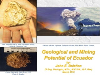
1. Geological and Mining Potential of Ecuador by: John E. Bolaños (P.Eng. Geologist, M.Sc., M.C.S.M., Q.P. Geo) March 2010
Gold Nugget of 300 g , from Rio Blanco, Azuay, Photo: RA Jemielita, 1992
Phreatic volcanic explosion, Pichincha volcano, 1999, Photo: Public Domain
Coarse placer gold, Napo River, 1999.
Photo: J. Bolaños
2. Ecuador Location Map Ecuador comprises 650 Km of the N portion of the Andes It is located to the N of the Huancabamba oroclinal deflection It is part of the Circum-Pacific Fire Belt
3. GEOLOGICAL AND MINING POTENTIAL OF ECUADOR
•The geological literature of Ecuador starts in 1892 when Teodoro Wolf published the study “Geography and Geology of Ecuador”.
•After Wolf, several authors published various geological papers describing geological and mineralogical targets in Ecuador (i.e. Holloway, 1932 among others).
•Later, during the 60´s to the 90´s, Ecuador signed international agreements for technical cooperation with several countries such as U.K., Japan, Belgium, Germany, etc.
•One of the most productive programs carried out in Ecuador was the “Environmental Control and Mining Development Project” (PRODEMINCA) carried out during 1997 and 1999 with the participation and financing of the World Bank and the Governments of U.K., Sweden and Ecuador.
BRIEF HISTORY OF THE GEOLOGY
4. Geological Map of the Republic of Ecuador, Scale: 1:1.000.000
British Geological Survey and CODIGEM , 1993
5. Tectono -Metallogenic Map of the Republic of Ecuador, Scale: 1:1.000.000
British Geological Survey and CODIGEM , 1993
7. Simplified geological map of the Andes of Ecuador, focusing on Tertiary arc magmatic units.
One main conclussions is: “The spatial- time distribution of the Cu porphyries and related epithermal mineralizations of the Peru metallogenic belts are very similar to those ones in Ecuador.
Inset adapted from Meschede & Barck- Hausen (2001); main map adapted from Litherland et.al. (1994), Steinmann (1977), Dunkley & Gaybor (1977), Mc Court et al. (1977), Pratt et al. (1997), Hughes et al. (1988), and Palacios et al. (2008).
(Ph.D. Thesis Geochronology, Gechemistry, and Isotopic Composition of Tertiary Porphyry Systems in Ecuador. Philip Shütte, 2010, University of Geneve)
GEOLOGICAL AND MINING POTENTIAL OF ECUADOR
8. GEOLOGICAL AND MINING POTENTIAL OF ECUADOR
From West to East Ecuador counts with 6 geo-structural domains:
1. The Fore Arc Basin of the Coast
2. Western Cordillera
3. Interandean Graven
4. Real or Central Cordillera
5. Eastern Subandean Zone
6. Back Arc Basin of Iquitos
(Figure after Litherland and Zamora 1991)
GEO-STRUCTURAL DOMAINS (Terranes)
9. GEOLOGICAL AND MINING POTENTIAL OF ECUADOR
•Is the lower and flat zone to the W.
•Cretaceous to Cenozoic basin underlain by aloctonous basaltic ocean crust (Ocean Piñon Terrane).
•Geo-mining potential:
Fe+Ti+PGMs sedimentary (Esmeraldas and Manabi)
Au+Fe+Cu placer deposits related to rivers on the W of the Western Cordillera.
Au+Sb+Hg+Ba Epi-Mesothermal deposits to the S of the Coast (El oro).
(Figure after Litherland and Zamora 1991)
1. The Fore Arc Basin of the Coast
10. GEOLOGICAL AND MINING POTENTIAL OF ECUADOR
2. Western Cordillera
• Mountain chain parallel to the Andean bearing.
• Located between the fore-arc of the Coast and the graven or interandean central valley.
• Formed by an accretionary prism mainly of ocean crust composition, continental crust and accreted Late Mesozoic to Cenozoic ocean terrains (Piñon, Pallatanga, Macuchi).
• It is overlain by calc-alkaline Post-Eocene continental margin volcanic sequences.
• Geo-Mining Potential:
Au+Pt placer deposits (i.e. rivers in Toisan Cordillera).
Au+Ag+Cu+Fe VHMS as those in the Macuchi Unit.
Cu+/-Au+/-Mo porphyry deposits (Imbabura, Bolivar and Azuay).
Au+ Cu High Sulphidation Epithermal Deposits (Macuchi Unit). (Figure after Litherland and Zamora 1991)
11. GEOLOGICAL AND MINING POTENTIAL OF ECUADOR
3. Inter-Andean Graven
•It is a graven valley bounded by regional faults with Andean bearing.
•Formed by thick and large Oligocene to Miocene volcano-sedimentary sequences that cover the Chaucha, Amotape and Guamote terrains with great mining potential.
•Au+Ag+/-Cu+As+Sb+Hg Epithermal deposits (Azuay and Loja).
•Cu+Mo+/-Au+/-Zn+/-Bi Porphyry deposits to the S of Ecuador
•Au+Ag+Cu+Zn+Pb Epi-Mesothermal deposits to the S of Ecuador.
•Sn+W associated to S type Granitoids in the Amotape terrain.
•Cu+Ni+Co+/-Cr+PGM´s deposits associated to ultramafic rocks and ophiolite complexes mainly in the Amotape terrain.
•Fe+Cu+Zn+/-Pb+Au VHMS related to the Amotape terrain.
•Cu+-Zn+Pb+Ba desposits related to granitoids on the Guamote division.
(Figure after Litherland and Zamora 1991)
12. •Formed by several litho-tectonic divisions of Andean bearing and separated by regional faults.
The Guamote division of flysch sediments, bounded eastwards by the ophiolitic Peltetec fault.
The Alao division, a mid-Jurassic oceanic island arc terrane bounded eastwards by the Baños fault.
The Loja division, a Triassic S-type biotite granite batholith with flanking semi-pelitic lithologies.
The Salado division of plutonic and island arc lithologies.
The Zamora division of continental plutonic and volcanic rocks.
In general it comprises Pre-Cretaceous metamorphic rocks intruded by S and I type intrusions.
This rocks are covered by Cenozoic volcanic.
(Figure Litherland et. al. 1994)
4. Real Cordillera
13. •Assosiated to the Alao Division are:
Ag+Au+Sb+Pb+Zn Epithermal deposits.
Fe+Cu+Pb+Zn+Ag+Au VHMS
Cu+Au+/-Mo Porphyry deposits
PGMs+Au deposits associated to mafic and ultramafic intrusions.
•Associated to the Loja Division (a Triassic S type intrusive) are:
Sn+W in S type granitoids.
Cu+Ag+Pb+Zn+Sn+/-W breccias bodies.
Au+Ag+Cu+As+Zn+Pb+Sb epithermal deposits.
•Associated to the Salado Division (plutonic and island arc lithologies) are:
Au+Cu+Mo+Pb+Zn skarn klippes.
Cu+Au epi-mesothermal deposits related to porphyries.
(Figure Litherland et. al. 1994)
4. Real Cordillera
14. GEOLOGICAL AND MINING POTENTIAL OF ECUADOR
•Summary of the Pre-Cretaceous geology of the Cordillera Real and sub-Andean zone (Jemielita and Bolaños, 1993)
DIVISION
(west to east)
GUAMOTE
P E L T E T E C F A U L T
ALAO
B A Ñ O S F A U L T
LOJA
L L A N G A N A T E S FA U L T
SALADO
C O S A N G A – M E N D E Z F A U L T
ZAMORA
SUBDIVISIONS /
LITHOLOGIES
Dark and pale orthoquartzites with slate/shale bands
Peltetec: dismembered
Ophiolite
Maguazo:
Turbidites.
Alao-Paute:
Andesitic green-stones, tuffs and sediments.
Tres Lagunas: biotite (garnet) granite and orthogneiss
Sabanilla: Ortho-and paragneiss, associated with semipelitic phyllites, schists and paragneisses.
Azafran: calc- alkaline batholith chain (diorite/granodiorite)
Upano: andesitic greenstones, tuffs black phyllites, graywackes and minor marbles.
Abitagua: calc-alkaline batholith chain.
Misahualli: andesites, dacites, basalts, and agglomerates.
Isimanchi: marbles and volcano-sedimentary rocks.
TECTONO METAMORPHIC STATE
Very low grade rocks overthrust W
Low grade rocks, steep fabrics, upright folds
Low to medium grade rocks thrust E with imbrications.
Low grade rocks thrust E with imbrications. High level skarnfield and serpentinite klippes
Essentially undeformed and unmetamorphosed
AGE
Upper Jurasic ?
Upper Jurasic (Callovian- Oxfordian)
? Triassic plutons in
?Palaeozoic sediments
Jurassic, with possible pre-Jurassic elements
Isimanchi: Triassic Igneous rocks: Jurassic
INTERPRETA- TION
Continetal sediments /
Clastic wedge
Ocean Floor, forearc and volcanic arc or marginal basin
S-type granites in
continentally – derived sediments
I-type plutons in volcano- sedimentary sequence
Continental I-type plutonic-volcanic arc
15. GEOLOGICAL AND MINING POTENTIAL OF ECUADOR
Possible collision model to account for the disposition of the individual lithotectonic divisions (Aspden and Litherland, 1991)
16.
17. GEOLOGICAL AND MINING POTENTIAL OF ECUADOR
5. Eastern Subandean Zone
•It comprises the Eastern slopes of the Andes Cordillera.
•It is formed by forearc belt of the basement covered by volcano-sedimentary sequences.
•It is intruded by large “I” type batholiths.
•To the N of this zone there is the Cordillera del Cutucu, an uplifted zone that host important prospects of Au+Cu+other.
•To the S there is the El Condor Cordillera which counts with tremendous mineral discoveries of Au+Cu+U+others.
18. GEOLOGICAL AND MINING POTENTIAL OF ECUADOR
6. Back Arc Basin of Iquitos
•It comprises the Oriente or Amazonian basin mainly form by sedimentary and volcano-sedimentary sequences.
•It hosts the most important oil field of Ecuador.
•Associated to it there are important Au+Fe placer deposits.
•Si deposits are associated to some sedimentary formations.
19. Summary of the Mining Potential related to the geo-structural domains (BGS 1994 and Prodeminca 2000).
20. ORE DISTRICTS IN ECUADOR
•With PRODEMINCA (2000) five ore districts were described:
1. Azuay Distric (Cordillera Occidental and Cordillera Real),
2. La Plata District (Cordillera Occidental),
3. Imbaoeste (Cordillera Occidental),
4. Alao Paute District (Cordillera Real).
5.Zamora District (Cordillera del Condor).
(Figure Fungeomine, 2008)
3
5
4
1
2
21. Porphyry copper sub-belts of the northern Andes (Modified from Sillitoe, Prodeminca, 2000)
Porphyry Cu+Mo+/-Au deposits are occurring within the Azuay District (i.e. Chaucha, Gaby&Papa Grande, Fierro Urcu, others), Imbaoeste District (i.e. Junin) and Zamora Districts (i.e. San Carlos, Cumay, Tumi, El Hito&Santa Barbara, Mirador). Porphyry type mineralization and intrusion related epi-mesothermal mineralization are known to occur within the litotectonic terranes of the Andean Cordillera of Ecuador. Each district has been subdivided into mineralized belts and orefields. For example: The Azuay District (Collay Shincata Belt, Molleturo ore field and Ponce Enriquez Orefield), the Zamora District (Nambija Belt, San Juan Bosco orefield and Pachicutza orefield).
22. High sulphidation epithermal deposits (alunite-Kaolinite) have been encountered in the Azuay District (Gañarin Belt, i.e. Quimsacocha; and Collay-Shincata Belt, i.e. El Mozo , Asaray, Cerro Colorado and Loma Quipal projects). Some other occurrences of this type of mineralization have been described to the south in the Loja Province (i.e. La Encrucijada and Quinapalma projects) suggesting the extension of the Collay- Shingata belt to the south.
Low sulphidation epithermal deposits/systems (adularia-sericite) have been described also in the Azuay District (Molleturo orefield i.e. Beroen project; Gañarin Belt i.e. Gañarin project; and Collay-Shicata Belt i.e. La Encrucijada project).
(Figure Prodeminca 2000).
EPITHERMAL DEPOSITS
23. Volcanic hosted massive sulphides have been related to the La Plata District (i.e La Plata and Macuchi projects) located on the western slopes of the Cordillera Occidental. Another important district for VHMS deposits is the Alao- Paute District located In the Cordillera Real (i.e. Pilas, Cruzacta and Guarumales projects). This VHMS deposits are Sierran-Kuroko types. Macuchi is an exception because its characteristics of not being strataform. (Figure Prodeminca 2000).
VHMS DEPOSITS
25. COMPANIES OF THE CONMIN
Bananas: 24,000 tpa:
30% of world’s market
Source: UNCTAD
Oil: 538,000 bpd State oil company Petroecuador produces 170,000 bpd Source CIA
Gold: 91,000 oz in 2000 reported from artisinal miners, mainly Nambija
Source USGS
Corriente’s Mirador
430mt @ 0.6% Cu 0.2g/t Au
International Mineral’s Gaby 6.3m oz @ 0.63 g/t Au
Dynasty’s Zaruma 1.1 moz @14g/t Au
Iamgold’s Quimsacocha
3.3m oz @ 3.2 g/t Au
Undeveloped Properties
Aurelian’s FDN
13m oz Au @ 7.23 g/t Au
26. DEPOSITTYPEMINERALIZATIONRESOURCESAuAgJUNINCu-Mo-Agqtz-py-cpy-bn-moly veins in potassic&transition982 Mt @0.9%Cu, N/A60Structurally controlled emplacement of quartzporphyryto phyllic alteration0.04 % Mo, 1.9 g/t Aggranodioritic and dioritic porphyriesTELIMBELACu-Mocpy- py, moly associated with mt in qz not availableN/AN/Aqtz-dioritic porphyry&dykesporphyrystockworks and brecciasCHAUCHACu-Mocpy-py bn &late cpy-moly in qtz stockworks &>120 Mt @0.5% Cu,N/AN/Atonalitic batholith, qtz porphyriesporphyrydisseminations in potassic - phyllic zones0.03 % MoQUINSACOCHAepith. High-sulf.py-en related to advanced argillic altyeration zone3.3 M Oz @3.2 g/t Au, 3.3N/Aandesite flows + intra caldera dacitic domesAu-Cu-Ag(adakitic); typical high-sulf. Alteration zoningGABY-PAPAAu-Cu porphyryassociated with breccias (py, mt matrix) in potassic6.3 M Oz @0.63 g/t Au6.3N/Ahbl/plag. Porphiries+tonalite intrusionGRANDEor Na-Ca alteration zones& 0.12 % CuCAÑICAPAepith. High sulf.sulfides oxidized; Au anomalies not understoodnot availableN/AN/Apre-mineralization dacites and post-min. AndesitesAutypical high sulf.-type alteration zoningCANGREJOSAu-Cu porphyryAu associated with disseminated cpy (moly)not availableN/AN/Aqtz-dioritic to granodioritic intrusions punctured by andesites + breccias; roots of eroded statovolcano? PORTOVELOporphyry &py-cpy-si-gn vein sets; disseimsted py-mt-cpy in1.1 M. Oz @14 g/t Au1.1N/Afault-bounded vein set originating from dioritic toZARUMAepithermal Aupotassic alteration zone of porphyrygranodioritic porphyy intrusionsEL MOZOepith. High-sulf.vuggy silica + argillic advanced alteration>180,000 Au Oz. 0.180N/Aporphiritic andesite lava, vulcano clastic breccias, Autuffs, hydrotherm. Brecccias, dacitic dykesLA PLATAvolcanog. massive sericite+silic. Halo, diss. Py, chl + epidot+qz0,913 Mt @8,01 g/t Au, 0.232.52lavas and andesitic tuffsulfide Au-Ag88.29 g/t Ag, 5.01% Cu, 0.78%Pbcarbonaceous and detritical sedimentsCu-Pb-Zn6.71% Zn(Macuchi Unit) CURIPLAYAAu-Cu porphyryAu-cpy-py-mt in qtz stockworks & disseminationsnot availableN/AN/Aqtz-dioritic to granodioritic intrusions punctured by in potassic - phyllic zonesandesites + breccias; structurally controlledSAN high - gradesphal.-py-pyrrhot.-galena-Aspy-cpy-boulang. +>55,000 T@20 Oz/t AgN/A1.1veins hosted in porphiritic andesitic lavasBARTOLOMEpolymetallic vein qz-rhodochr.-dolomit. Carbonat. In veins2.9%Zn, 1.15% ZPb +/- Auand volcanics of Saraguro FormationsystemMOLLETUROhigh - gradenative silver, electrum, pyrite, sphalerite, galena392 g/t Ag, 3.4 g/t Au, N/AN/AYounger granodiorite and quartz diorite intrudingpolymetallic veinpyrrhotite, arsenopyrite, tetrahedrite, chalcocite0,69%Cu, 2.3%Pb, 4.24% Znthe volcanic Macuchi Unit. Mineralizationsystemand covellitein E-W vein systemFRUTA DEL high gradechalcedonic to crystalline quartz, mangan.-carbonat.58.9 Mt@7.23 g/t Au, 11.8 g/t Ag13.722.34The gold-silver mineralization at FDN is associatedNORTEintermediate-calcite, adularia, barite, marcasite, total 13,689,500 Au Oz.with veins, stockworks and disseminations, mainlysulphidation- goldpyrite as well as subordinate sphalerite, galena,in moderately to intensely silicified Misahuallí epithermal depositcpy with trace tetrah. and other silver sulphosaltsAndesite. Silicification and gold-silvermineralization are well developed at and belowthe basal contact of the Suarez FormationMIRADORCu-Au porphyryearly Mo, early Cu+-Au and later copper gold stages438 Mt @ 0.61 % Cu, 0.19 g Au/t 2.6722.4well defined alteration zonong, quartz-sericite (Corriente Mo is associated with early qz veining, both copper-1.59g/t Ag,total measured and overprintig K alt. Covering a large part of the wallResources Inc)gold events are sulphide dominatedindicated resources categorizationrock and qtz diorite porphyry. RIO BLANCOlow sulfidationquartz veins with calcedonic massive silica, banded 2.1 Mt @ 9.5 g Au/t, 69 g/t Ag0.644.66lavas and volcaniclastic rocks of predominant epithermal veinsand colloform textures with Au- electrum -py-Aspy-total measured and indicated andesitic composition (Saraguro Formation) galena-pirargirite.resourcesTotal28.120113.02ECUADOR MAIN DEPOSITS -Geological settings. LITHOLOGYIN SITU M Oz
27. 3
FRUTA DEL NORTE DEPOSIT October, 2009
FDN - Location and Concessions
28. Intermediate sulphidation epithermal mineralisation: quartz-carbonate- sulphide stockwork veining & brecciation.
FDN Deposit Geology
Andesite
Conglomerate
Late Andesite
125m
350m
?
250 m @ 35.18 g/t Au and 27.1 g/t Ag
30. Concessions
4 copper deposits with a total of 25 billions of pounds (cut-off of 0.4% Cu)
Similar Geology, simple mineralisation
South sector > Cu-Au, north zone > Cu.
Mineralisation identified by soil / sediments geochemichal survey.