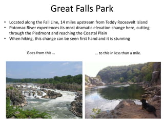
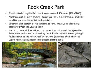
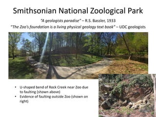
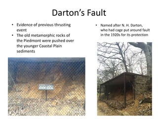
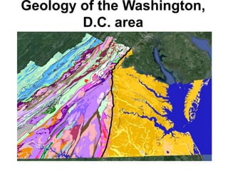
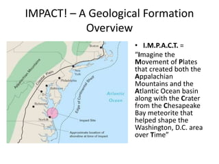
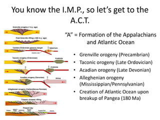
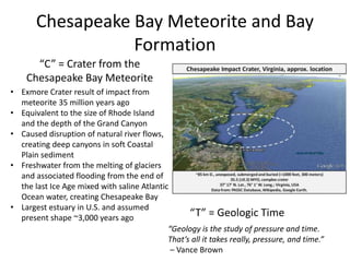
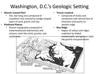
Geology of the Washington,
D.C. area
IMPACT! – A Geological Formation
Overview
• I.M.P.A.C.T. =
“Imagine the
Movement of Plates
that created both the
Appalachian
Mountains and the
Atlantic Ocean basin
along with the Crater
from the Chesapeake
Bay meteorite that
helped shape the
Washington, D.C. area
over Time”
You know the I.M.P., so let’s get to the
A.C.T.
• Grenville orogeny (Precambrian)
• Taconic orogeny (Late Ordovician)
• Acadian orogeny (Late Devonian)
• Alleghenian orogeny
(Mississippian/Pennsylvanian)
• Creation of Atlantic Ocean upon
breakup of Pangea (180 Ma)
“A” = Formation of the Appalachians
and Atlantic Ocean
Chesapeake Bay Meteorite and Bay
Formation
“C” = Crater from the
Chesapeake Bay Meteorite
• Exmore Crater result of impact from
meteorite 35 million years ago
• Equivalent to the size of Rhode Island
and the depth of the Grand Canyon
• Caused disruption of natural river flows,
creating deep canyons in soft Coastal
Plain sediment
• Freshwater from the melting of glaciers
and associated flooding from the end of
the last Ice Age mixed with saline Atlantic
Ocean water, creating Chesapeake Bay
• Largest estuary in U.S. and assumed
present shape ~3,000 years ago “T” = Geologic Time
“Geology is the study of pressure and time.
That’s all it takes really, pressure, and time.”
– Vance Brown
Washington, D.C.’s Geologic Setting
• Atlantic Coastal Plain
• Flat, low-lying area composed of
crystalline rock covered by wedge-shaped
layers of sand, gravel, and clay
• Piedmont Plateau
• Diverse topography composed of
metamorphosed sedimentary and
volcanic rocks like schist, granite, and
sandstones
• Triassic Lowland
• Composed of shales and
sandstones with alluvial fans of
limestone and quartz on
western edge
• Blue Ridge
• Region of valleys and ridges
underlain by folded
metamorphic and igneous rocks
like granite and greenstone
The Terraces of Washington, D.C.
The Fall Line
“...we were intercepted with great craggy stones that
[stand] in midst of the river, where the water falleth so
rudely and with such a violence as not any boat could
possibly pass...” – John Smith (1607)
• Line of rapids and falls marking where the waters
rushing over the Piedmont encounter the easily
erodible sediments of the Coastal Plain
Teddy Roosevelt Island
Great Falls Park
• Located along the Fall Line, 14 miles upstream from Teddy Roosevelt Island
• Potomac River experiences its most dramatic elevation change here, cutting
through the Piedmont and reaching the Coastal Plain
• When hiking, this change can be seen first hand and it is stunning
Goes from this … … to this in less than a mile.
Rock Creek Park
• Also located along the Fall Line, it covers over 2,800 acres (7% of D.C.)
• Northern and western portions home to exposed metamorphic rock like
boulder gneiss, mica schist, and quartzite
• Southern and eastern portions home to sand, gravel, and silt closely
associated with the Coastal Plain
• Home to two rock formations, the Laurel Formation and the Sykesville
Formation, which are separated by the 1.8-mile wide system of geologic
faults known as the Rock Creek Shear Zone (evidence of which in the
Laurel Formation is shown in the figure on the right)
Smithsonian National Zoological Park
“A geologists paradise” – R.S. Bassler, 1933
“The Zoo’s foundation is a living physical geology text book” – UDC geologists
• U-shaped bend of Rock Creek near Zoo due
to faulting (shown above)
• Evidence of faulting outside Zoo (shown on
right)
Darton’s Fault
• Named after N. H. Darton,
who had cage put around fault
in the 1920s for its protection
• Evidence of previous thrusting
event
• The old metamorphic rocks of
the Piedmont were pushed over
the younger Coastal Plain
sediments
The Building Stones of D.C. and a Brief
History of the National Mall
Old stones from the CapitolKensington tonaliteRed sandstone
Fun with Maps!
1976 version 2016 version
Thank You!

Mike_Stoever_Slides

  • 1.
    Geology of theWashington, D.C. area
  • 2.
    IMPACT! – AGeological Formation Overview • I.M.P.A.C.T. = “Imagine the Movement of Plates that created both the Appalachian Mountains and the Atlantic Ocean basin along with the Crater from the Chesapeake Bay meteorite that helped shape the Washington, D.C. area over Time”
  • 3.
    You know theI.M.P., so let’s get to the A.C.T. • Grenville orogeny (Precambrian) • Taconic orogeny (Late Ordovician) • Acadian orogeny (Late Devonian) • Alleghenian orogeny (Mississippian/Pennsylvanian) • Creation of Atlantic Ocean upon breakup of Pangea (180 Ma) “A” = Formation of the Appalachians and Atlantic Ocean
  • 4.
    Chesapeake Bay Meteoriteand Bay Formation “C” = Crater from the Chesapeake Bay Meteorite • Exmore Crater result of impact from meteorite 35 million years ago • Equivalent to the size of Rhode Island and the depth of the Grand Canyon • Caused disruption of natural river flows, creating deep canyons in soft Coastal Plain sediment • Freshwater from the melting of glaciers and associated flooding from the end of the last Ice Age mixed with saline Atlantic Ocean water, creating Chesapeake Bay • Largest estuary in U.S. and assumed present shape ~3,000 years ago “T” = Geologic Time “Geology is the study of pressure and time. That’s all it takes really, pressure, and time.” – Vance Brown
  • 5.
    Washington, D.C.’s GeologicSetting • Atlantic Coastal Plain • Flat, low-lying area composed of crystalline rock covered by wedge-shaped layers of sand, gravel, and clay • Piedmont Plateau • Diverse topography composed of metamorphosed sedimentary and volcanic rocks like schist, granite, and sandstones • Triassic Lowland • Composed of shales and sandstones with alluvial fans of limestone and quartz on western edge • Blue Ridge • Region of valleys and ridges underlain by folded metamorphic and igneous rocks like granite and greenstone
  • 6.
    The Terraces ofWashington, D.C.
  • 7.
    The Fall Line “...wewere intercepted with great craggy stones that [stand] in midst of the river, where the water falleth so rudely and with such a violence as not any boat could possibly pass...” – John Smith (1607) • Line of rapids and falls marking where the waters rushing over the Piedmont encounter the easily erodible sediments of the Coastal Plain
  • 8.
  • 9.
    Great Falls Park •Located along the Fall Line, 14 miles upstream from Teddy Roosevelt Island • Potomac River experiences its most dramatic elevation change here, cutting through the Piedmont and reaching the Coastal Plain • When hiking, this change can be seen first hand and it is stunning Goes from this … … to this in less than a mile.
  • 10.
    Rock Creek Park •Also located along the Fall Line, it covers over 2,800 acres (7% of D.C.) • Northern and western portions home to exposed metamorphic rock like boulder gneiss, mica schist, and quartzite • Southern and eastern portions home to sand, gravel, and silt closely associated with the Coastal Plain • Home to two rock formations, the Laurel Formation and the Sykesville Formation, which are separated by the 1.8-mile wide system of geologic faults known as the Rock Creek Shear Zone (evidence of which in the Laurel Formation is shown in the figure on the right)
  • 11.
    Smithsonian National ZoologicalPark “A geologists paradise” – R.S. Bassler, 1933 “The Zoo’s foundation is a living physical geology text book” – UDC geologists • U-shaped bend of Rock Creek near Zoo due to faulting (shown above) • Evidence of faulting outside Zoo (shown on right)
  • 12.
    Darton’s Fault • Namedafter N. H. Darton, who had cage put around fault in the 1920s for its protection • Evidence of previous thrusting event • The old metamorphic rocks of the Piedmont were pushed over the younger Coastal Plain sediments
  • 13.
    The Building Stonesof D.C. and a Brief History of the National Mall Old stones from the CapitolKensington tonaliteRed sandstone
  • 14.
    Fun with Maps! 1976version 2016 version
  • 15.

Editor's Notes

  • #2 Figure source: http://www.virginiaplaces.org/regions/fallshape.html
  • #3 Figure source: http://www.space.com/22909-ancient-asteroid-impacts-earth-effects.html
  • #4 Figure sources: http://www.rci.rutgers.edu/~schlisch/103web/NJcontext/ENAhistory.html
  • #5 Figure source: http://impactcraters.us/chesapeake_bay_virginia Quote source: https://books.google.co.in/books?id=4mEPmOGMU1oC&pg=PA172&hl=en#v=onepage&q&f=false
  • #6 Figure source: http://pubs.usgs.gov/gip/stones/setting.html
  • #7 Figure source: https://thegrowingseason.wordpress.com/
  • #8 Figure and quote sources: http://www.virginiaplaces.org/regions/fallshape.html; http://nationalzoo.si.edu/AboutUs/History/beneathitall.cfm
  • #9 Figure source: http://www.virginiaplaces.org/regions/fallshape.html
  • #10 Figure source: http://pxhdwsm.com/nike+park+great+falls+va; the author’s personal photo
  • #11 Figure sources: http://www.savetherockcreekparkdeer.com/rock-creek-park.html; http://blogs.agu.org/mountainbeltway/2013/04/29/kink-bands-in-highly-strained-laurel-formation-rock-creek-shear-zone-dc/
  • #12 Figure source: The author’s personal photos
  • #13 Figure source: The author’s personal photos
  • #14 Figure source: http://washington.org/DC-guide-to/smithsonian-institution-building-castle; http://www.explorenaturalcommunities.org/parks-places/rock-creek-park/natural-history/physical-setting/geology; http://www.washingtoncitypaper.com/articles/37113/stone-cold-whodunit
  • #15 Figure sources: http://pubs.usgs.gov/of/1976/0849/plate-2.pdf; http://ngmdb.usgs.gov/Prodesc/proddesc_277.htm