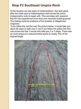
This document provides a guide to the geology of Central Park in New York City. It is divided into three sections. Section one describes the building stones used in park structures. Section two examines bedrock outcroppings, showing evidence of NYC's tectonic history over billions of years. Section three inspects evidence left behind by glaciers, including striations and erratic boulders deposited during the last ice age. Stops around the park are detailed, identifying rock types and geological features formed by metamorphism, intrusions, erosion and glaciation.
And now for something very different:
Evidence that banded iron formations formed very rapidly
and a proposed YE correlation.
Enjoy the food for thought in this extraordinary period we are all experiencing!
A dissertation project in partial completion of Durham Universities Geology F600 Program with funding from Durham Universities Department of Earth Sciences. Fieldwork was carried out over a period of 6 weeks from the Oystercatcher House B&B, Raasay.
2013 Top 10 List of Hot Trends in Greenroof & Greenwall DesignAramis Velazquez
Our Top 10 List is designed to be an eye catching and fast-paced presentation of case study vignettes representing the selected top ten categories highlighting the very best of what's hot now - according to our editorial sensibilities peppered with media and designer reports from around the globe. Whether based on traditional applications with a twist or avant-guard projects combining living roofs and walls, energy, and other green technologies, we select time-honored examples from which we designers can draw inspiration to current conceptual, high-profile media grabbing greenroofs and greenwalls which stimulate and entice the senses!
Running head: DETAILED GEOLOGICAL TRIP REPORT
1
DETAILED GEOLOGICAL TRIP REPORT
2
Detailed Geological Trip Report
Name
Institution Affiliation
Detailed Trip Report: First Part
7:45 a.m. We departed from Campus.
We drove north on Highway 101. As we continued north through the Highway, we passed through Yachats, a town that is approximately 75 miles. Just on the left past the Adobe Motel was the turn-off to Smelt Sands Beach which was our first stop. ( that’s all copied)
Stop 1: Smelt Sands Beach.
Smooth and brown rocks are molded together by wet beach sand. The sand is, however, coarse with contents including, quartz, basalt, shell pieces, serpentine and agates. The rock forming the base rock formation is present in the sand signifying the rock is broken down by erosion.
Different rocks are also exposed and are believed to be from the Cenozoic Era. They are featured as part of the Yachats Basalt and are Late Eocene (36-40 million years) in age. These rocks were formed as a result of the cooling of magma from a series of eruptions ( this is all copied from that cheater essay.. not hard to tell see I told you… KEEP This I will alter (Alt and Hyndman 1978).
There is the existence of a Pleistocene terrace where the town of Yachats is built. The terrace was probably formed when the sea level was lower, and its deposit is 10,000 to 1.8 million years old. It cuts into the Yachats basalt sequence (Snavely, 1980). Its present level, which is above, the present sea level, is attributed to either the rise of land due to tectonic activity or dropping of the sea level. It is, however, difficult to know where the uplift of the land is possible in such an active coastline. The Smelt Sands Beach is located to the South of the start of Yaquina formation. A basalt flow is found at this spot. It lies beneath the Pleistocene terrace. This basalt is about 40 million years old. The Pleistocene, on the other hand, is about 1.8 years old. What happened between the formation of the basalt and the Pleistocene is not known yet. However, some researchers speculate that land movement could have occurred which led to dropping of the sea level or rising of the land. The whole town of Yachats has been built on this beach terrace.
Information about the town of Yachats indicates that much is of it occurs in a zone that prone to tsunami if another Cascadia subduction occurs. The part of the town, which is not, in the tsunami zone is found on the hillside. However, this part also risks destruction from the tsunami-causing earthquake. Studies carried out by researchers indicate 50m of beach would retreat in this region should a cascadia subduction occur (Snavely, 1980). This means that the biggest part of the Yachats town would be destroyed considering that most of the premises in the town, which include shops, hotels and residential houses are within a distance of 50m from the water. Plants found in this region include bog anemones and gold-eyed grasses..
Draw a flow chart to illustrate the cycle that a grain of sand goes th.docxrtodd4
Draw a flow chart to illustrate the cycle that a grain of sand goes through according to the following passage. Your illustration should be based on the knowledge and information you have learned from the passageSummary Writing of Natural History of a Sand Grain The first part explains in detail the formation of the Sierra Nevada batholith in California during the Mesozoic Cretaceous. The subduction of the oceanic crust led to heat production, making the magma more buoyant and viscous, which led to the creation. As the lava gradually cooled and solidified, it gave rise to the granitic column that would later become the Sierra Nevada Batholith. Silicon and oxygen, along with other elements, formed crystals including quartz, feldspar and mica, the main elements in the batholiths. The mountains were created by tectonic action that elevated the granite core rocks and stripped away the surrounding rock layers. The quartz-rich sand that was exposed may have eventually turned into sandstone. California has fewer dinosaur fossils than other western states because of the restricted terrestrial environment of the Mesozoic era. Part II describes the voyage of a sand grain, beginning with how it formed in the Sierra Nevada batholith and ending with how it eventually reached the ocean. Sand grains were transported by rivers and streams to an ancient coastal basin where they were deposited in sandstone layers. The sandstone was raised by tectonic action and then broken up by weathering and erosion. The sand grains traveled through streams and mass erosion during physical and chemical weathering. Over time, it continued to flow faster in wider channels and downslopes, eventually reaching the ocean. This section highlights how anthropogenic barriers, such as dams, and changes in vegetation cover, such as after wildfires, may affect the long-term evolution of erosional and depositional environments. In particular, winter storms in California during fire season have resulted in some of the highest sediment yields ever recorded in the state's streams and rivers. Part III describes the journey of this sand grain from quartz crystals in granite batholiths to its eventual home on the seafloor. Streams and rivers carried the sand grains to an ancient coastal basin, where they were deposited with other materials and turned into sandstone. As tectonics raised it above sea level, the sandstone was exposed, worn and degraded over time. Eventually, the sand grains were carried into the ocean and dumped on beaches where they were subjected to waves and tides. The trapped sand grains then formed an integral part of a fresh sedimentary layer that was lithified into the sandstone at the bottom of the submarine canyon. In addition, this section describes the many beach sands that may be found in California, such as quartz, gypsum, feldspar, mica, hornblende, and magnetite, as well as scattered deposits of tar and asphalt. How human efforts, such as dam construction and beach.
“The Plains of Abraham: A History of North Elba and Lake Placid — Collected Writings of Mary MacKenzie” was published in 2007 by Nicholas K. Burns Publishing, a one-man publishing house in Utica, New York. When the book finally went to press, much of the material gathered from the late Mrs. MacKenzie’s files by editor Lee Manchester had to be put aside to keep the volume from becoming too big to print; even so, “The Plains of Abraham” ran to more than 400 pages in length. Rather than leave completely aside the rest of the material that had been edited for “The Plains of Abraham,” Manchester decided to make it available in a small, paperback edition. TO PURCHASE A BOUND, PRINT EDITION, GO TO http://stores.lulu.com/marymackenzie
·
archaeocyathid
o
Cambrian - sessile, reef-building marine organisms of warm tropical and subtropical waters that lived during the early (lower) Cambrian period.
·
bioturbation
o
Cambrian - the reworking of soils and sediments by animals or plants. Its effects include changing texture of sediments (diagenetic), bioirrigation and displacement of microorganisms and non-living particles. Common bioturbators include annelids and bivalves (mussels, clams, gastropods).
·
Burgess Shale
o
Cambrian - located in the Canadian Rockies of British Columbia, is one of the world's most celebrated fossil fields. It is famous for the exceptional preservation of the soft parts of its fossils. At 505 million years (Middle Cambrian) old, it is one of the earliest fossil beds containing soft-part imprints.
·
Cambrian explosion
o
Cambrian - the relatively rapid appearance, around 530 million years ago, of most major animal phyla, as demonstrated in the fossil record, accompanied by major diversification of organisms
·
Iapetus Ocean
Cambrian/Ordovician - Precursor to the Atlantic. An ocean that existed in the Neoproterozoic and Paleozoic eras of the geologic timescale (between 600 and 400 million years ago). The ocean disappeared with the Caledonian, Taconic and Acadian orogenies, when these three continents joined to form one big landmass called Laurussia.
maturity Cambrian
·
Paleozoic Era
o
Cambrian - the earliest of three geologic eras of the Phanerozoic Eon, spanning from roughly 541 to 252.2 million years ago. It is the longest of the Phanerozoic eras, and is subdivided into six geologic periods (from oldest to youngest): the Cambrian, Ordovician, Silurian, Devonian, Carboniferous, and Permian.
·
passive margin
o
Cambrian - the transition between oceanic and continental crust which is not an active plate margin. It is constructed by sedimentation above an ancient rift, now marked by transitional crust. Continental rifting creates new ocean basins.
·
trilobite
o
Cambrian - extinct marine arthropods that form the class Trilobita. Trilobites form one of the earliest known groups of arthropods. Trilobites finally disappeared in the mass extinction at the end of the Permian about 250 million years ago. The trilobites were among the most successful of all early animals, roaming the oceans for over 270 million years.
·
bentonites
o
Ordovician - essentially impure clay consisting mostly of montmorillonite. Bentonite usually forms from weathering of volcanic ash, most often in the presence of water. However, the term bentonite, as well as a similar clay called tonstein, has been used to describe clay beds of uncertain origin.
·
Cincinnati arch
o
Ordovician - when continents crashed together during the two orogeny's you have the Appalachian mountains and then a down drop into the Appalachian basin going west and then going west the next rise is the Cincinnati arch and the next basin is the Illinois basin.
epeir.
Transcript: Selling digital books in 2024: Insights from industry leaders - T...BookNet Canada
The publishing industry has been selling digital audiobooks and ebooks for over a decade and has found its groove. What’s changed? What has stayed the same? Where do we go from here? Join a group of leading sales peers from across the industry for a conversation about the lessons learned since the popularization of digital books, best practices, digital book supply chain management, and more.
Link to video recording: https://bnctechforum.ca/sessions/selling-digital-books-in-2024-insights-from-industry-leaders/
Presented by BookNet Canada on May 28, 2024, with support from the Department of Canadian Heritage.
Smart TV Buyer Insights Survey 2024 by 91mobiles.pdf91mobiles
91mobiles recently conducted a Smart TV Buyer Insights Survey in which we asked over 3,000 respondents about the TV they own, aspects they look at on a new TV, and their TV buying preferences.
Neuro-symbolic is not enough, we need neuro-*semantic*Frank van Harmelen
Neuro-symbolic (NeSy) AI is on the rise. However, simply machine learning on just any symbolic structure is not sufficient to really harvest the gains of NeSy. These will only be gained when the symbolic structures have an actual semantics. I give an operational definition of semantics as “predictable inference”.
All of this illustrated with link prediction over knowledge graphs, but the argument is general.
GDG Cloud Southlake #33: Boule & Rebala: Effective AppSec in SDLC using Deplo...James Anderson
Effective Application Security in Software Delivery lifecycle using Deployment Firewall and DBOM
The modern software delivery process (or the CI/CD process) includes many tools, distributed teams, open-source code, and cloud platforms. Constant focus on speed to release software to market, along with the traditional slow and manual security checks has caused gaps in continuous security as an important piece in the software supply chain. Today organizations feel more susceptible to external and internal cyber threats due to the vast attack surface in their applications supply chain and the lack of end-to-end governance and risk management.
The software team must secure its software delivery process to avoid vulnerability and security breaches. This needs to be achieved with existing tool chains and without extensive rework of the delivery processes. This talk will present strategies and techniques for providing visibility into the true risk of the existing vulnerabilities, preventing the introduction of security issues in the software, resolving vulnerabilities in production environments quickly, and capturing the deployment bill of materials (DBOM).
Speakers:
Bob Boule
Robert Boule is a technology enthusiast with PASSION for technology and making things work along with a knack for helping others understand how things work. He comes with around 20 years of solution engineering experience in application security, software continuous delivery, and SaaS platforms. He is known for his dynamic presentations in CI/CD and application security integrated in software delivery lifecycle.
Gopinath Rebala
Gopinath Rebala is the CTO of OpsMx, where he has overall responsibility for the machine learning and data processing architectures for Secure Software Delivery. Gopi also has a strong connection with our customers, leading design and architecture for strategic implementations. Gopi is a frequent speaker and well-known leader in continuous delivery and integrating security into software delivery.
Accelerate your Kubernetes clusters with Varnish CachingThijs Feryn
A presentation about the usage and availability of Varnish on Kubernetes. This talk explores the capabilities of Varnish caching and shows how to use the Varnish Helm chart to deploy it to Kubernetes.
This presentation was delivered at K8SUG Singapore. See https://feryn.eu/presentations/accelerate-your-kubernetes-clusters-with-varnish-caching-k8sug-singapore-28-2024 for more details.
"Impact of front-end architecture on development cost", Viktor TurskyiFwdays
I have heard many times that architecture is not important for the front-end. Also, many times I have seen how developers implement features on the front-end just following the standard rules for a framework and think that this is enough to successfully launch the project, and then the project fails. How to prevent this and what approach to choose? I have launched dozens of complex projects and during the talk we will analyze which approaches have worked for me and which have not.
Software Delivery At the Speed of AI: Inflectra Invests In AI-Powered QualityInflectra
In this insightful webinar, Inflectra explores how artificial intelligence (AI) is transforming software development and testing. Discover how AI-powered tools are revolutionizing every stage of the software development lifecycle (SDLC), from design and prototyping to testing, deployment, and monitoring.
Learn about:
• The Future of Testing: How AI is shifting testing towards verification, analysis, and higher-level skills, while reducing repetitive tasks.
• Test Automation: How AI-powered test case generation, optimization, and self-healing tests are making testing more efficient and effective.
• Visual Testing: Explore the emerging capabilities of AI in visual testing and how it's set to revolutionize UI verification.
• Inflectra's AI Solutions: See demonstrations of Inflectra's cutting-edge AI tools like the ChatGPT plugin and Azure Open AI platform, designed to streamline your testing process.
Whether you're a developer, tester, or QA professional, this webinar will give you valuable insights into how AI is shaping the future of software delivery.
LF Energy Webinar: Electrical Grid Modelling and Simulation Through PowSyBl -...DanBrown980551
Do you want to learn how to model and simulate an electrical network from scratch in under an hour?
Then welcome to this PowSyBl workshop, hosted by Rte, the French Transmission System Operator (TSO)!
During the webinar, you will discover the PowSyBl ecosystem as well as handle and study an electrical network through an interactive Python notebook.
PowSyBl is an open source project hosted by LF Energy, which offers a comprehensive set of features for electrical grid modelling and simulation. Among other advanced features, PowSyBl provides:
- A fully editable and extendable library for grid component modelling;
- Visualization tools to display your network;
- Grid simulation tools, such as power flows, security analyses (with or without remedial actions) and sensitivity analyses;
The framework is mostly written in Java, with a Python binding so that Python developers can access PowSyBl functionalities as well.
What you will learn during the webinar:
- For beginners: discover PowSyBl's functionalities through a quick general presentation and the notebook, without needing any expert coding skills;
- For advanced developers: master the skills to efficiently apply PowSyBl functionalities to your real-world scenarios.
Search and Society: Reimagining Information Access for Radical FuturesBhaskar Mitra
The field of Information retrieval (IR) is currently undergoing a transformative shift, at least partly due to the emerging applications of generative AI to information access. In this talk, we will deliberate on the sociotechnical implications of generative AI for information access. We will argue that there is both a critical necessity and an exciting opportunity for the IR community to re-center our research agendas on societal needs while dismantling the artificial separation between the work on fairness, accountability, transparency, and ethics in IR and the rest of IR research. Instead of adopting a reactionary strategy of trying to mitigate potential social harms from emerging technologies, the community should aim to proactively set the research agenda for the kinds of systems we should build inspired by diverse explicitly stated sociotechnical imaginaries. The sociotechnical imaginaries that underpin the design and development of information access technologies needs to be explicitly articulated, and we need to develop theories of change in context of these diverse perspectives. Our guiding future imaginaries must be informed by other academic fields, such as democratic theory and critical theory, and should be co-developed with social science scholars, legal scholars, civil rights and social justice activists, and artists, among others.
Let's dive deeper into the world of ODC! Ricardo Alves (OutSystems) will join us to tell all about the new Data Fabric. After that, Sezen de Bruijn (OutSystems) will get into the details on how to best design a sturdy architecture within ODC.
The Art of the Pitch: WordPress Relationships and SalesLaura Byrne
Clients don’t know what they don’t know. What web solutions are right for them? How does WordPress come into the picture? How do you make sure you understand scope and timeline? What do you do if sometime changes?
All these questions and more will be explored as we talk about matching clients’ needs with what your agency offers without pulling teeth or pulling your hair out. Practical tips, and strategies for successful relationship building that leads to closing the deal.
UiPath Test Automation using UiPath Test Suite series, part 3DianaGray10
Welcome to UiPath Test Automation using UiPath Test Suite series part 3. In this session, we will cover desktop automation along with UI automation.
Topics covered:
UI automation Introduction,
UI automation Sample
Desktop automation flow
Pradeep Chinnala, Senior Consultant Automation Developer @WonderBotz and UiPath MVP
Deepak Rai, Automation Practice Lead, Boundaryless Group and UiPath MVP
UiPath Test Automation using UiPath Test Suite series, part 3
A guide to central park
1. A Guide to Central ParkAlicia SorrentiSpring 2010
2. Table of Contents Map of Central Park With Specific Sites The Purpose of This Guide Summary of Geologic Formations of New York City Summary of the Tectonic History of New York Glaciations and Their Affect on New York Section I Structures Stop A Maine Monument Stop B Restrooms Stop C Greyshot Arch Section II Formations and Tectonics Stop D Outcrop 1 Stop D2 Outcrop 2 Stop E Outcrop 3 Rat Rock Stop F Southwest of Umpire Rock Stop F2 Southeast side of Umpire Rock Stop F3 East side of Umpire Rock Section III Glaciation Stop F4 West side of Umpire Rock Stop F5 North side of Umpire Rock Stop G Pegmatite Boulder Stop H Outcrop RoucheMoutonnee Geologic Time Scale Diagrams of Orogenies Conclusion 3 4 5 6 7 8 10 11 13 15 16 17 18 19 20 21 22 24 25 26 27 31
3. The Purpose of This Guide When one wants to study the natural world, New York City is the last place people think of to start investigating. This guide is designed to change peoples minds and prove NYC, like every other place in the world, has been greatly affected by natural processes. Section one, will take a quick glance at building stones within the park. Even the seemingly un-natural aspects of the park have their own natural story. Section two examines the outcroppings of bedrock, taking the reader for a journey through time and providing evidence of NYC’s active tectonic history. The third section will inspect the evidence glaciers left behind as they made their voyage from the north pole, scouring the land beneath.
4. Summary of Geologic Formations Exposed in NYC Fordham Gneiss: Gneiss that is exposed in Fordham bronx. It formed over 1 billion years ago during the Grenville Orogeny, when a landmass (unknown) collided with Proto-North America. This was also part of the formation of Rodinia. The banding within the gneiss is often contorted, which is proof of the extreme heat and pressure. Figure 1 Forham Gneiss Manhattan Schist: Schist that is exposed in Manhattan. It formed when the Taconic Orogeny (Poto- North America collided with the Taconic Arcs), metamorphosed the parent rocks, shale, sands and basalt of the early Cambrian. Figure 2 Manhattan Schist Inwood Marble: Marble that is exposed in Inwood Manhattan. It formed when the Taconic Orogeny (Proto- North America collided with the Taconic Arcs), metamorphosed carbonate sedimentary deposits of the Cambrian and Early Ordovician. Figure 3 Inwood Marble
5. Tectonic History of New York Earth’s face is forever changing partly due to plate tectonics. When two plates converge, an orogeny is a common result, but when two plates diverge away from each other, also known as rifting, a basin is created. New York State has been affected by both of these processes. Roughly one billion years ago the formation of Rodinia, a super continent, produced huge mountains known as the Grenville Mountains. It later eroded leaving sediment on either side of these once colossal mountains. The rifting of Rodina, which began 740 million years ago formed a proto-ocean; Iapetus. This proto-ocean became a basin where sediment was able to collect. A passive margin of the Cambrian and early Ordovician allowed for broad continental shelves to form, making shallow seas abundant, which is ideal for deposition of limestone and shale. During the early Cambrian Proto-America began to subduct under the off shore Taconic Arcs. By the early odovicianIapetus began to close. Just as the formation of Rodinia created the Grenville Mountains, this convergence produced the Taconic orogeny. This collision caused scrapping up of continental mud and sand, as the convergence continued regional metamorphism began, turning sedimentary deposits into the metamorphic rocks schist and marble. Another orogeny was on the horizon, as Avalon (future Eastern New England) subducted under Proto-America, this would result in the Acadian Orogeny, which began 400 million years ago. And last but not least, another supercontinent would form, when Proto-Africa began subducting under Proto-America 320 Million years ago. It would result in both the AlleghanianOrogeny and Pangea. Super continents are unstable and it was not long before volcanism and rifting began spitting it apart. The Atlantic ocean began to open 160 million years ago.
6. Glaciations Affects on New York Aside from tectonics, earth’s face specifically New York City has also been modified by glaciers. Glaciers are slow moving ice sheets formed from compacted snow and the constant push of gravity. They can be several hundred feet thick and can cover several thousand square feet. There are two common types of glaciers; alpine glaciers, which form in mountains, and Continental ice sheets, which cover larger areas. During the Pleistocene epoch, 1.8 million years ago to about 10,000 years ago North America experienced several advances of glaciers. The most recent sheet to affect the continent was the North American Laurentide Ice Sheet, which is broken up into episodes. The last episode was the Wisconsin. This time is a keystone in human history because this is when the land bridge between Siberia and Alaska formed, Beringia Land Bridge. This allowed humans to migrate into North America and then into South America. Evidence of the Wisconsin episode is recorded in New York and throughout North America in the form of scours, and pooling of melted ice (lakes). When a glacier advances across a continent is scours the land, these marks are called striations and grooves. If the glacier begins to retreat a moraine is formed, which is a linear mound of un-sorted sediment. When glaciers begin to thin-out and or retreat the ice can no longer hold boulders that its been transporting, and they are deposited, this boulder will likely be different than the surrounding bedrock, it would now be called a glacial erratic.
7. Stop A Maine Monument Architecture The Maine Monument was designed by H. Van Buren Magonigle and Attilio Piccirilli with a Beaux-Arts architectural style. The bronze figure above which is part horse and part sea creature represents Americas position as a dominant world figure. Its location was debated over for sometime, originally it was going to be placed near the harbor to welcome ships, Times Square, (then Longacre Square) was also an option, but the designers decided Columbus Circle was the best location. History The Maine Monument was built to honor the 258 American Sailors that lost their lives on February 15, 1898 when the Maine Battleship exploded in the Harbor of Havana. By April of 1898 Spain declared war on America, which would end with the signing of the Treaty of Paris in December 1889. Inscribed on the monument is “valiant seamen who perished on the Maine by fate unwarned, in death unafraid” .
8. Building Stones of Maine Monument The body of the monument was constructed with Tennessee Marble. This particular rock is actually a limestone, not a marble. It formed in the Ordovician. It varies in colors of pink and gray, with styolites. Limestone is a common stone used for sculptures because it can be easily carved into shapes, but repairs on the sculpture are evidence that it is easily weathered and damaged. The base of the monument was constructed with Milford Granite. This particular rock was probably quarried from Massachusetts. This granite was formed in the Precambrian. It has a light pink color, with spots of biotite that in some cases are oriented, giving it the name “gneissic”. Granite is durable due to its interlocking crystals and high quartz content so it is often used for bases of buildings and sculptures.
9. Stop B Restroom Facility Building Stones Portland Brownstone Fordham Gneiss Portland Brownstone- Is quarried from Connecticut. This particular sandstone formed in the Early Jurassic. This coarse sandstone is up to 65% feldspar, making it a feldspathicarenite. The reddish color comes from an iron oxide, hematite. It was likely added later for aesthetic reasons. Fordham Gneiss- is exposed in Fordham bronx. It formed over 1 billion years ago during the Grenville Orogeny, when a landmass (unknown) collided with Proto-North American. The banding within the gneiss is often contorted, which is proof of the extreme heat and pressure. It was likely used because it was readily available and durable. Figure 1 is a large crystal of amphibole. Figure 1
10. Stop C Greyshot Arch History and Architecture Greyshot Arch is located within the park, Central Park West between 61st and 62nd Streets. Most of the arch was completed in 1861. It is similar to Green Gap Arch, an early design by Calvert Vaux. The arch is topped with a hundred foot long sandstone balustrade, featuring fleur-de-lis design. The eighty foot arched opening often gets flooded with muddy water, and is a constant nuisance to the maintenance team of NYC parks.
11. Building Stones of Greyshot Arch The face of the arch is made of Fordham Gneiss, notice the well foliated layers of amphibole and quartz below. amphibole Quartz The balustrade of the arch is made of New Bruswick Sandstone, moderately grained and tan in color. This sandstone, which is mostly quartz formed in the upper Triassic.
12. Stop D Outcrop This was the first stop that we looked at outcroping of the bedrock. We determined it as bedrock and not a boulder because of its size, shape, all sides under ground, and the fact that there were several outcroppings of the same kind of rock. We identified it as schist because of its coarse interlocking crystals of quartz, mica, amphibole and feldspar, moderate foliation and overall dark color. We took the direction of foliation, it is oriented 40˚ NE; we did this so we could compare it to the other exposures and see if they are truly of the same formation. Muscovite. The large amount of mica in these schist exposures causes it to be referred to as mica-schist
13. Quartz lenses The large quartz lenses that we see throughout the outcrops of Manhattan Schist exist because there was not only shale being metamorphosed during the Taconic Orogeny, but sandstone as well. Had it not been metamorphosed, Manhattan Schist would have still looked like figure 1; which is a picture of sediment that was deposited underwater, then an orogeny uplifted it, allowing us to observe it at the surface. This outcrop was not metamorphosed, as it is still the sedimentary rocks sandstone and shale. It is known as the Martinsburg Formation, which can be seen in New Paltz New York. Martinsburg is located beneath an unconformity that is believed to be the Taconic Orogeny, meaning the deposit existed before the orogeny took place. The red arrow is sandstone, and the blue arrow is shale. Figure two on the other hand is what is seen in central park, Manhattan Schist, which was metamorphosed during the Taconic Orogney, converting the shale into schist and the sandstone into lenses of quartz, figure 2. Sandstone Shale Figure 1. Martinsburg Formation in New Paltz, NY (Not metamorphosed) Quartz lens Schist, which is formed from the metamorphism of the parent rock shale Figure 2. A two foot long quartz lens within Manhattan Schist
14. Stop D2 Out Crop As we approached this outcrop, it looked as the first did, dark and submerged in the ground on all sides. After taking a closer look we decided it was the same, Manhattan schist. It has coarse grains of quartz, amphibole, micas and feldspar. More impressing is the fact that the foliation was in the same 40˚ NE direction, further adding to the idea that it is an exposure of Manhattan Schist. Additional investigations led us to find both quartz and pegmatitic dikes, which are vertical intrusions. The bedrock also has signs of once being ductile, in the form of folding, as seen in the picture below. The red arrow is pointing to one of the folded ridges. These folds could have only been made my extreme pressure, such as converging plates.
15. Stop E Rat Rock Similar to the earlier outcrops, this stop was an outcropping of Manhattan Schist. The foliation is also oriented to the NE, about 40˚. The most interesting part of this stop was the 3D view of a small pegmatitic dike. One side of the rock is cut for a stairwell which gives a unique cross section of the outcrop, and you can see the vertical sheet intrusion (dike) from two sides the stairs and the top (bird’s eye-view).
16. Stop F1 Southwest Umpire Rock This outcropping of Manhattan Schist posed a new question for Geo 13. Are we seeing evidence of glaciations in the form of grooves or is this differential erosion? We performed two tests, first we took the orientation of both the grooves and the foliation, they were a match, 38˚NE. This supported differential erosion because it is unlikely that the grooves would perfectly form parallel to the foliation. The second test we performed was a hardness test, using a nail we scratched both the highest point of the groove and the lowest point, the ridge was harder; this also supported the theory that what we were seeing was differential erosion not glacier created scours, striations. The area in question can be seen below in figure 1. Figure 1 This is an example of differential erosion, due to the foliation of the schist. When a rock becomes foliated, different minerals make up each band, and in this case you can see that the stronger minerals are more resistant to weathering and therefore are more pronounced. The red arrow is pointing to where the stronger minerals are forming a small ridge.
17. Stop F2 Southeast Umpire Rock At this location we saw signs of metamorphism that took place after the initial case of metamorphism that formed the schist (metamorphic rock) to begin with. This coincides with research that NY has experienced more than one mountain building period. This folding could be evidence of the Acadian or Allegahnianorogenies. If you follow the red line over the picture below, it would take you about 20 steps to walk over it, but if you follow the yellow line that cuts across the fold, it would only take you 2 or 3 steps. There was so much pressure it reduced these layers to nearly 10% of the original length.
18. Stop F3 East Umpire Rock On the east side of Umpire Rock we saw a great example of cross cutting relationships, which helps geologists give an age to rock layers. There were two dikes cutting through the bedrock, one was a small pegmatitic dike and the other was a larger fine grained granite dike. In one section of the bedrock these two dikes crossed each other. The large dike cut through the smaller one, which means the smaller one is older because it would have already had to be there in order to be intersected by the large granite dike. This out crop and set of intrusions record different periods of tectonic activity first the initial metamorphism of the schist, the metamorphism of the first intrusion, and last the intrusion of the second dike. Above the large granite dike (red arrow) cuts through the other, smaller pegmatitc dike (blue arrow). The large dike is also not as metamorphosed which is another indicator that it came after the pegmatitic dike.
19. Stop F4 West Umpire Rock This is the first stop we were able to determine true evidence of glaciers, scouring called striations were present. Unlike F1 the grooves were perpendicular to the foliation (differential erosion would be parallel to the foliation.) We took a measurement of 330˚and 150˚ which coincides with research, that the glaciers came from the northwest, and traveled southeast. The blue arrows show the faint grooves and their direction, the red arrow is the foliation which is in a different direction.
20. Stop F5 North Umpire Rock On the north side of Umpire Rock we studied three boulders. One was the same material as the bedrock, Manhattan Schist, but the others were different. Although they to were dark in color, they were not foliated and had different crystal sizes. The boulders were noticeably more rounded than those of Manhattan Schist, which indicates traveling. The picture below is of a weathered rounded boulder. A freshly broken piece allowed one to see the fine crystals and It became more obvious that this was basalt, an extrusive igneous rock (figure 1). We asked ourselves, how did these boulders of basalt and gabbro get here? Someone could have put them there, but the fact that they are the same material of outcroppings northwest of Central Park, and again well rounded (traveled) suggests they may be erratic boulders. As the glaciers traveled, they carried sediment and boulders with them, and deposited them when they thinned out and or retracted. These boulders are believed to be from the Palisades Sill in NJ. Figure 1. An erratic boulder, Basalt.
21. Stop G Boulder Central Park was completed in 1873, before the usage of motor vehicles. Therefore this boulder that stands approximately 1.8 meters off the ground and weighs several tons, was probably not brought in during the time of design. An alternative theory of origin is that it was deposited by a glacier. See next page for composition/ close ups
22. Composition of Stop G Boulder plagioclase feldspar, Approximately 1 inch in length Muscovite Quartz
23. Stop H Outcrop This stop was again looking at Manhattan Schist, this specific location had clear glacier scours, striations. We took a measurement of the direction of the stiations,145˚. Which is similar to that of stop F4, indicating the striations were made at the same time.
24. Roche Moutonnee RoucheMoutonnee is a feature left behind by glaciers. The smooth mound as seen in the picture below is formed as a glacier flows over a rock surface, water seeps into cracks, which than freezes. Water expands when it freezes so pieces of the rock will break off, the pieces will than freeze to the bottom of the glacier. As the glacier continues to flow across the surface it takes the newly attached pieces of rock with it, in a process called “plucking”. Area that was “plucked” Direction the glacier flowed
25. Geologic Time Scale Glaciations (Wisconsin Episode) AlleghanianOrogeny Acadian Orogeny Taconic Orogeny Deposition of the mud that would become Manhattan Schist Grenville Orogeny
26. Diagram of Orogenies The Grenville Orogenyoccurred when an unidentified land mass subducted under Proto- North America. This Orogeny metamorphosed sedimentary deposits forming Gneiss, Fordham Gneiss. Diagrams from Geology of New York: A Simplified Account By Y.W Isachsen
27. The Taconic Orogenyoccurred when Proto- North America subducted under The Taconic Island Arcs. This Orogeny metamorphosed sedimentary deposits forming Schist, Manhattan Schist. Diagrams from Geology of New York: A Simplified Account By Y.W Isachsen
28. The Acadian Orogenyoccurred when Avalon subducted under Proto- North America. Diagrams from Geology of New York: A Simplified Account By Y.W Isachsen
29. TheAlleghanianOrogenyoccurred when Proto- Africa subducted under Prot- North America. This would leave New York Sate at the heart of the super-continent, Pangea. Diagrams from Geology of New York: A Simplified Account By Y.W Isachsen
30. Conclusion By the end of this trip, one should be certain that New York City has been part of an amazing journey, and still is. The world is forever changing and sometimes we are lucky enough to find clues that help piece together our world’s history. We learned that a broad continental shelf formed on a passive margin, allowed for deposits of mud to accumulate. The mud was then transformed into a metamorphic rock (Manhattan Schist), because of the heat and pressure caused by the Taconic Orogeny. Further pressure from later orogenies caused folding to occur within the schist. Heat and pressure would not be the last ground shaping event that New York Formations would endure, glaciers left their mark as well. Long island would not exist had the glaciers not deposited enormous amounts of sediment. The next time you take a trip through New York City, make sure you appreciate the natural history that is preserved in Central Park.