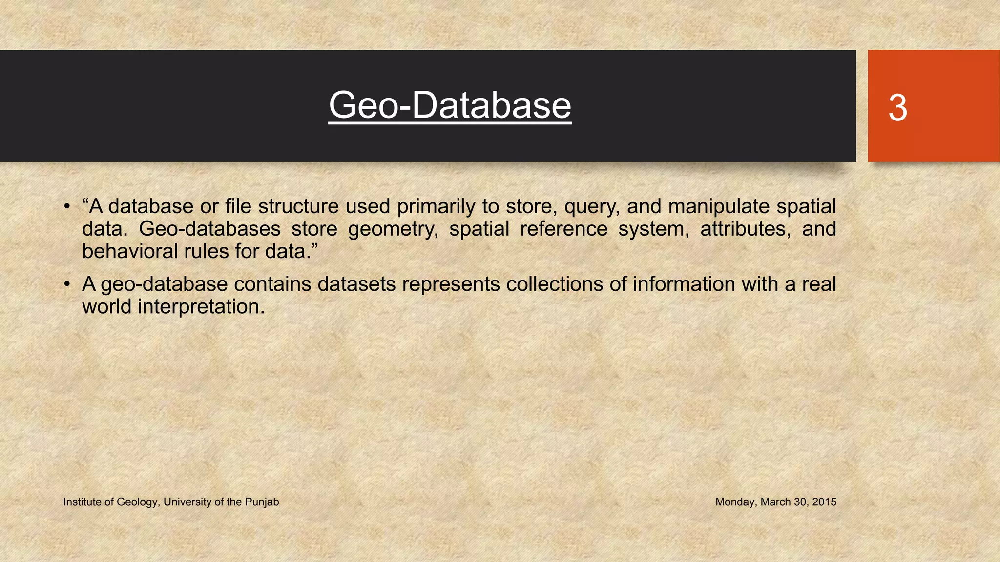
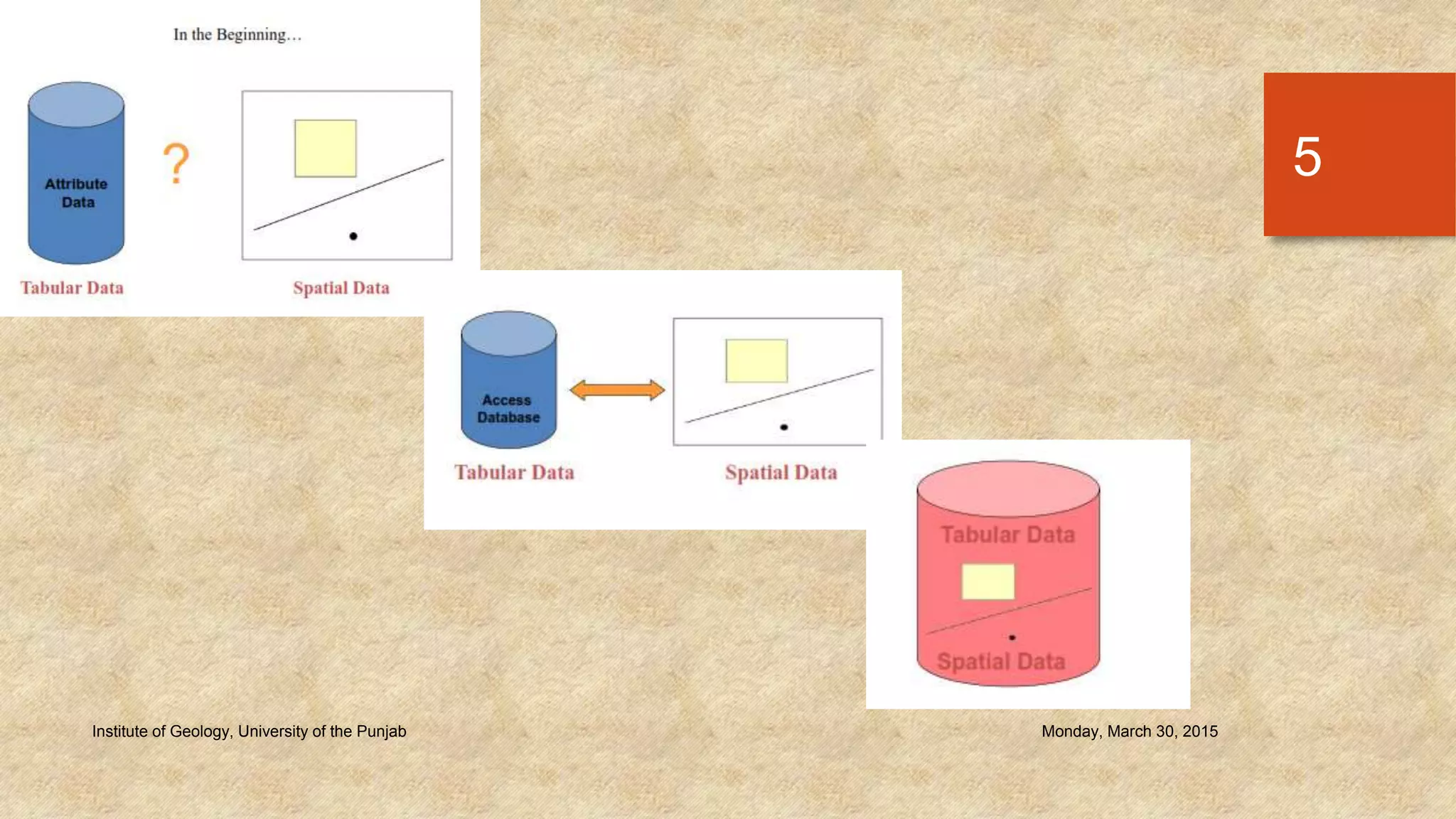
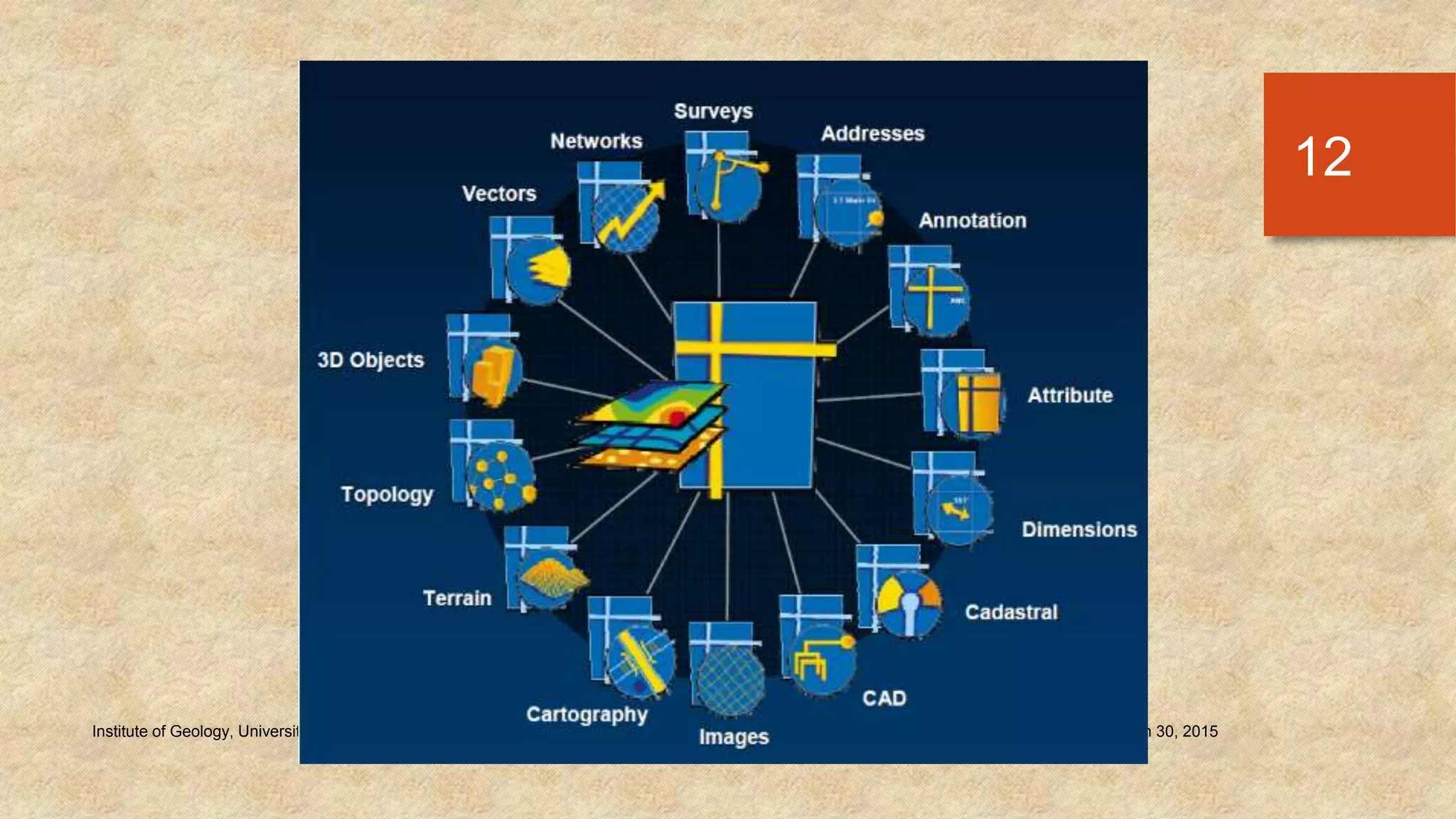
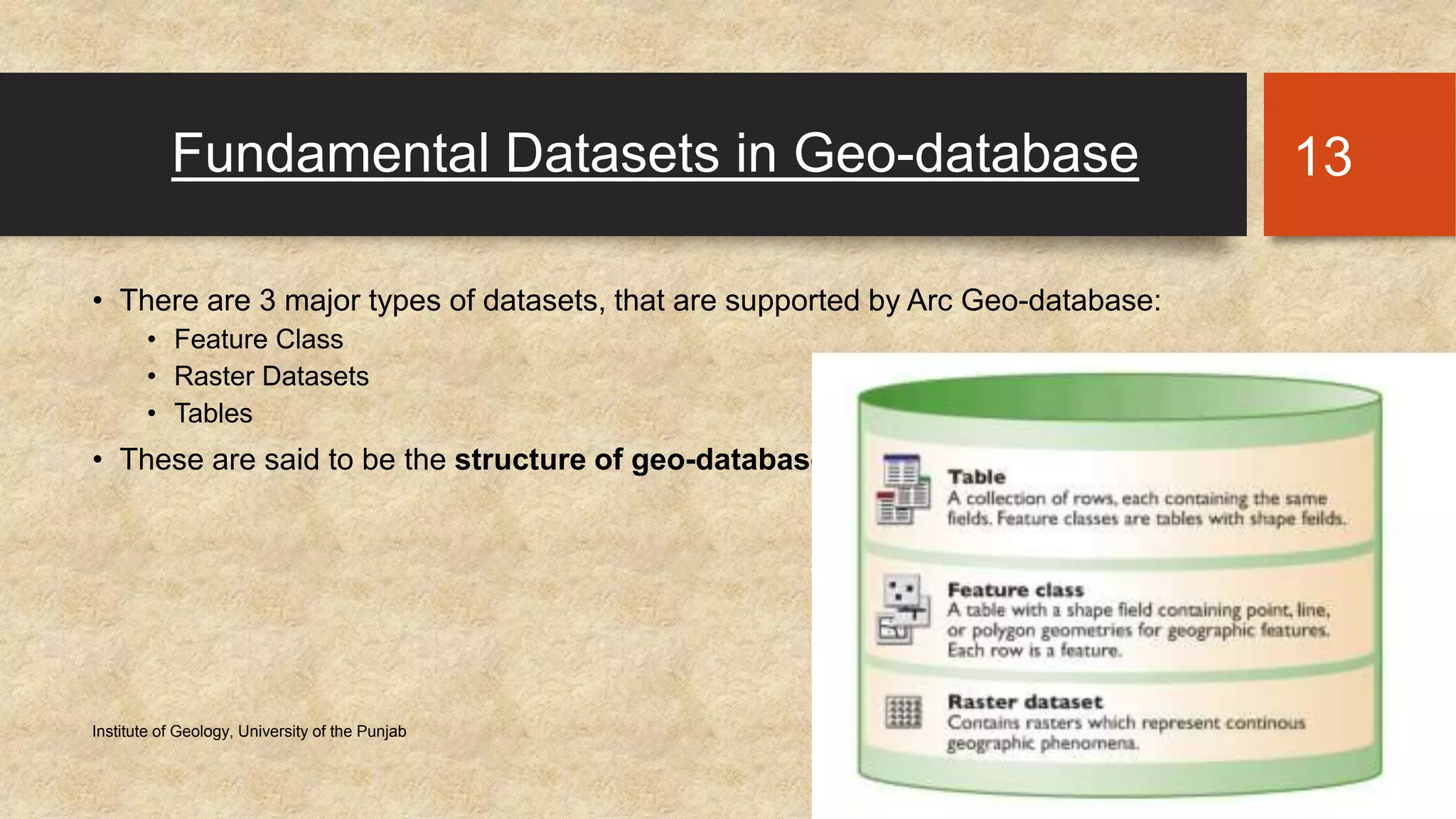
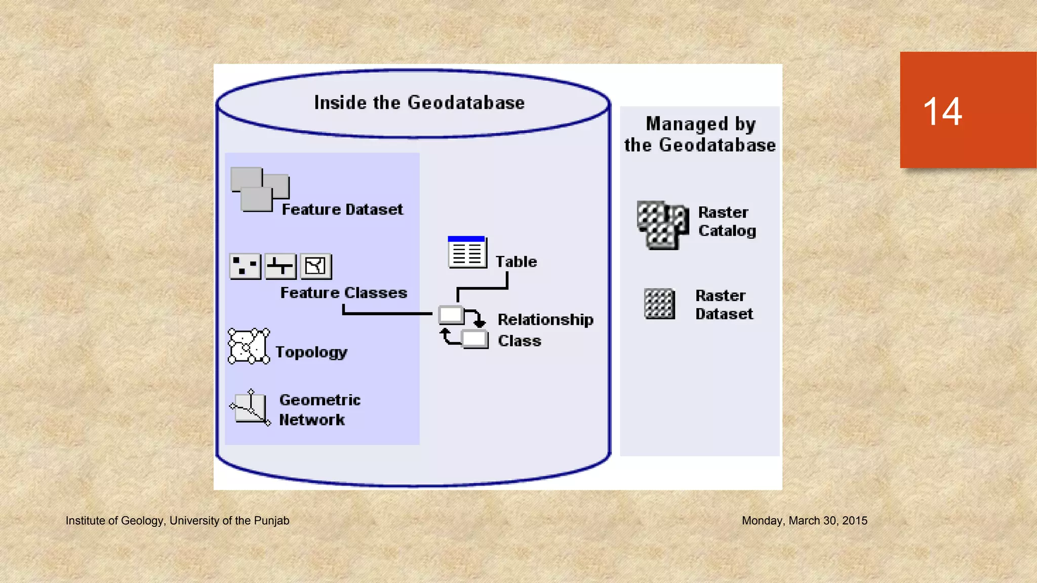
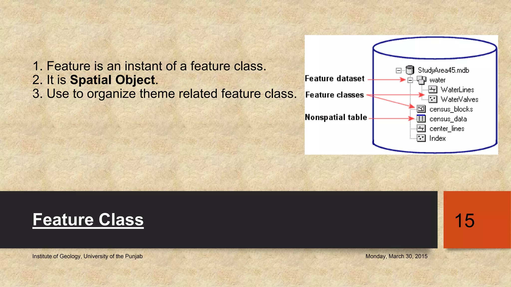
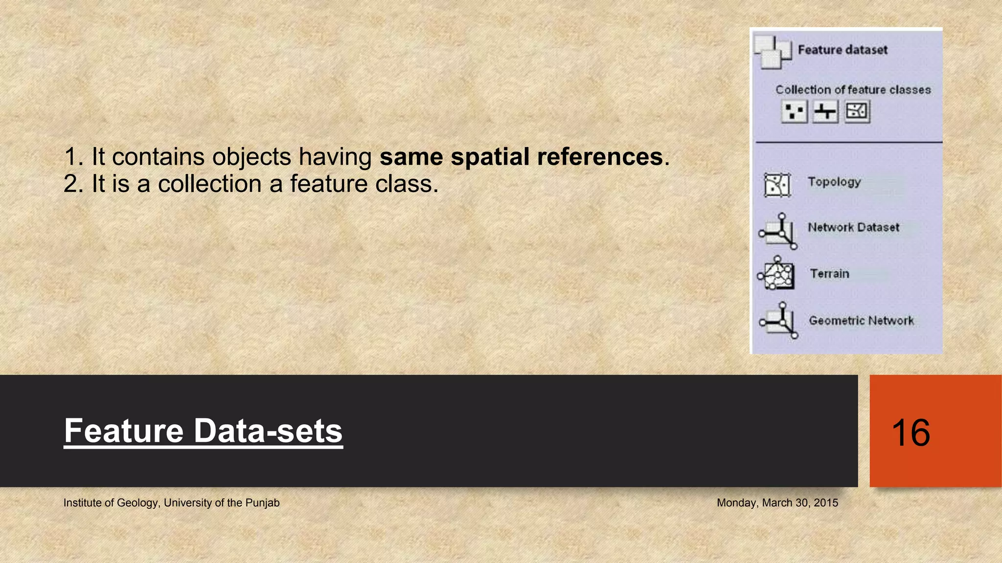
Introduction to Geo-database
and Topology
Prof. Dr. Sajid Rashid Ahmad
sajidpu@yahoo.com
Atiqa Ijaz Khan _ Demonstrator
atiqa_ss09@yahoo.com
GEO-DATABASE
Monday, March 30, 2015Institute of Geology, University of the Punjab
2
Geo-Database
• “A database or file structure used primarily to store, query, and manipulate spatial
data. Geo-databases store geometry, spatial reference system, attributes, and
behavioral rules for data.”
• A geo-database contains datasets represents collections of information with a real
world interpretation.
Monday, March 30, 2015Institute of Geology, University of the Punjab
3
History
• In the beginning, there is NO link between Spatial and Non-spatial data.
• 1st Generation:
• Then, both get linked, but stored in separate files.
• 2nd Generation:
• Finally, the spatial and non-spatial datasets are stored in Same table/folder.
Monday, March 30, 2015Institute of Geology, University of the Punjab
4
Monday, March 30, 2015Institute of Geology, University of the Punjab
5
Geo-Database In ArcGIS
• An ArcGIS geo-database is a collection of geographic datasets of various
types held in a common file system folder.
• It is a native data structure, used to edit and manage the data.
• It maintain the integrity of the spatial data.
• It store comprehensive information related with each other through objects,
feature classes, feature datasets, etc.
• It is a container used to store information.
• It has easy access and management options.
• Users can apply sophisticated rules and operations to data through it.
• It supports multi-user editing.
Monday, March 30, 2015Institute of Geology, University of the Punjab
6
Why to Use it: Benefits
• It is more robust (strong) and extendable than shapefile.
• It make use full capabilities of ArcGIS.
• Support multi-user editing.
• Faster and efficient.
• Manage large datasets easily.
• Use to edit topology.
• Non-spatial data is stored in standard format. Like DBMS (DataBase
Management System)
Monday, March 30, 2015Institute of Geology, University of the Punjab
7
Types of Geo-Database
• There are 2 major types:
• Single-user Geo-database:
• Personal
• File
• Multi-user Geo-database:
• Enterprise
Monday, March 30, 2015Institute of Geology, University of the Punjab
8
Geo-
Database
Single
user
File
Personal
Multi-user
Enterprise
Monday, March 30, 2015Institute of Geology, University of the Punjab
9
Monday, March 30, 2015Institute of Geology, University of the Punjab
10
Key Properties Personal File
Description Original data format for
ArcGIS geo-databases
stored and managed in
Microsoft Access data files
A collection of various types
of GIS datasets held in a
file system folder
Number of Users Single user and small
workgroups with smaller
datasets
Single user and small
workgroups:
Storage Capacity 1TB-256TB 2GB
Supported Platforms Supported by Widows Supported by Cross-
platforms
Security Operating Windows
Data Type Supported by Geo-database
• The data types supported by geo-database are:
• Shapefile
• Computer Aided Drafting (CAD)
• Triangular Irregular Networks (TIN)
• Grids
• Imagery
• Attribute tables
• Raster Data
• Grids
• GPS coordinates
• Survey measurements, etc.
Monday, March 30, 2015Institute of Geology, University of the Punjab
11
Monday, March 30, 2015Institute of Geology, University of the Punjab
12
Fundamental Datasets in Geo-database
• There are 3 major types of datasets, that are supported by Arc Geo-database:
• Feature Class
• Raster Datasets
• Tables
• These are said to be the structure of geo-database.
Monday, March 30, 2015Institute of Geology, University of the Punjab
13
Monday, March 30, 2015Institute of Geology, University of the Punjab
14
1. Feature is an instant of a feature class.
2. It is Spatial Object.
3. Use to organize theme related feature class.
Feature Class
Monday, March 30, 2015Institute of Geology, University of the Punjab
15
1. It contains objects having same spatial references.
2. It is a collection a feature class.
Feature Data-sets
Monday, March 30, 2015Institute of Geology, University of the Punjab
16
TOPOLOGY
Monday, March 30, 2015Institute of Geology, University of the Punjab
17
Topology
• “A branch of mathematics that deals with the properties of a figure that remains
unchanged ever when the figure is bent, stretched, or otherwise distorted.”
• “In geo-databases, topology is the arrangement that defines how point, line, and
polygon features share coincident geometry.”
Monday, March 30, 2015Institute of Geology, University of the Punjab
18
Types of Topology
Topology
Map
Topology
Geo-
database
Topology
Monday, March 30, 2015Institute of Geology, University of the Punjab
19
Map Topology
• “A temporary set of topological relationships between coincident parts simple
features on a map, used to edit shared parts of multiple features.”
• Allows user to edit on scree, by adjusting edges (lines), nodes (end points of
lines), etc.
• Can be applied to shapefile and feature class.
• It does not use topology rules.
• Provides with limited version of topology.
• Available at Topology toolbar.
Monday, March 30, 2015Institute of Geology, University of the Punjab
20
Geo-database Topology
• “Geo-database topology defines the spatial relationships of data that all feature
classes must be in the same feature datasets”
• It can only be created for vectors, not for raster.
• It stores errors, exceptions etc.
• It has more extensive rules of topology.
• It can manage and fix the topological errors.
Monday, March 30, 2015Institute of Geology, University of the Punjab
21
Topological Convention
• A topology can reference one or more feature classes from the same feature
dataset.
• A feature dataset can have more than one topology.
• However, a feature class can only belong to one topology.
• A feature class cannot belong to a topology and a geometric network.
Monday, March 30, 2015Institute of Geology, University of the Punjab
22
Topology Rules
• “A group of instruction to the geo-database defining the permissible relationships
of features within a given feature class or between features in two different feature
classes.”
• Different types of rules are available for different types of spatial relationships.
• Some rules are for within a feature class.
• Some rules are for between two feature classes.
• There are 26 rules available in ArcGIS Topology, having 3 divisions:
• Polygon Rules
• Line Rules
• Point Rules
Monday, March 30, 2015Institute of Geology, University of the Punjab
23
Monday, March 30, 2015Institute of Geology, University of the Punjab
24
Download the Rules Poster: Link
http://www.google.com.pk/imgres?imgurl=https://apollomapping.com/wp-
content/user_uploads/2014/05/topology_rules_poster-
300x234.jpg&imgrefurl=https://apollomapping.com/blog/g-faq-spatial-topology-gis-
part&h=234&w=300&tbnid=whDwfYDh4DhTtM:&zoom=1&docid=Lak_ZoGKneoPr
M&ei=7Z8VVdyCFI3uatHbgqgO&tbm=isch&ved=0CCYQMygNMA0
Monday, March 30, 2015Institute of Geology, University of the Punjab
25
Monday, March 30, 2015Institute of Geology, University of the Punjab
26

Lec_12_Intro to Geodatabase and Topology

  • 1.
    Introduction to Geo-database andTopology Prof. Dr. Sajid Rashid Ahmad sajidpu@yahoo.com Atiqa Ijaz Khan _ Demonstrator atiqa_ss09@yahoo.com
  • 2.
    GEO-DATABASE Monday, March 30,2015Institute of Geology, University of the Punjab 2
  • 3.
    Geo-Database • “A databaseor file structure used primarily to store, query, and manipulate spatial data. Geo-databases store geometry, spatial reference system, attributes, and behavioral rules for data.” • A geo-database contains datasets represents collections of information with a real world interpretation. Monday, March 30, 2015Institute of Geology, University of the Punjab 3
  • 4.
    History • In thebeginning, there is NO link between Spatial and Non-spatial data. • 1st Generation: • Then, both get linked, but stored in separate files. • 2nd Generation: • Finally, the spatial and non-spatial datasets are stored in Same table/folder. Monday, March 30, 2015Institute of Geology, University of the Punjab 4
  • 5.
    Monday, March 30,2015Institute of Geology, University of the Punjab 5
  • 6.
    Geo-Database In ArcGIS •An ArcGIS geo-database is a collection of geographic datasets of various types held in a common file system folder. • It is a native data structure, used to edit and manage the data. • It maintain the integrity of the spatial data. • It store comprehensive information related with each other through objects, feature classes, feature datasets, etc. • It is a container used to store information. • It has easy access and management options. • Users can apply sophisticated rules and operations to data through it. • It supports multi-user editing. Monday, March 30, 2015Institute of Geology, University of the Punjab 6
  • 7.
    Why to Useit: Benefits • It is more robust (strong) and extendable than shapefile. • It make use full capabilities of ArcGIS. • Support multi-user editing. • Faster and efficient. • Manage large datasets easily. • Use to edit topology. • Non-spatial data is stored in standard format. Like DBMS (DataBase Management System) Monday, March 30, 2015Institute of Geology, University of the Punjab 7
  • 8.
    Types of Geo-Database •There are 2 major types: • Single-user Geo-database: • Personal • File • Multi-user Geo-database: • Enterprise Monday, March 30, 2015Institute of Geology, University of the Punjab 8 Geo- Database Single user File Personal Multi-user Enterprise
  • 9.
    Monday, March 30,2015Institute of Geology, University of the Punjab 9
  • 10.
    Monday, March 30,2015Institute of Geology, University of the Punjab 10 Key Properties Personal File Description Original data format for ArcGIS geo-databases stored and managed in Microsoft Access data files A collection of various types of GIS datasets held in a file system folder Number of Users Single user and small workgroups with smaller datasets Single user and small workgroups: Storage Capacity 1TB-256TB 2GB Supported Platforms Supported by Widows Supported by Cross- platforms Security Operating Windows
  • 11.
    Data Type Supportedby Geo-database • The data types supported by geo-database are: • Shapefile • Computer Aided Drafting (CAD) • Triangular Irregular Networks (TIN) • Grids • Imagery • Attribute tables • Raster Data • Grids • GPS coordinates • Survey measurements, etc. Monday, March 30, 2015Institute of Geology, University of the Punjab 11
  • 12.
    Monday, March 30,2015Institute of Geology, University of the Punjab 12
  • 13.
    Fundamental Datasets inGeo-database • There are 3 major types of datasets, that are supported by Arc Geo-database: • Feature Class • Raster Datasets • Tables • These are said to be the structure of geo-database. Monday, March 30, 2015Institute of Geology, University of the Punjab 13
  • 14.
    Monday, March 30,2015Institute of Geology, University of the Punjab 14
  • 15.
    1. Feature isan instant of a feature class. 2. It is Spatial Object. 3. Use to organize theme related feature class. Feature Class Monday, March 30, 2015Institute of Geology, University of the Punjab 15
  • 16.
    1. It containsobjects having same spatial references. 2. It is a collection a feature class. Feature Data-sets Monday, March 30, 2015Institute of Geology, University of the Punjab 16
  • 17.
    TOPOLOGY Monday, March 30,2015Institute of Geology, University of the Punjab 17
  • 18.
    Topology • “A branchof mathematics that deals with the properties of a figure that remains unchanged ever when the figure is bent, stretched, or otherwise distorted.” • “In geo-databases, topology is the arrangement that defines how point, line, and polygon features share coincident geometry.” Monday, March 30, 2015Institute of Geology, University of the Punjab 18
  • 19.
    Types of Topology Topology Map Topology Geo- database Topology Monday,March 30, 2015Institute of Geology, University of the Punjab 19
  • 20.
    Map Topology • “Atemporary set of topological relationships between coincident parts simple features on a map, used to edit shared parts of multiple features.” • Allows user to edit on scree, by adjusting edges (lines), nodes (end points of lines), etc. • Can be applied to shapefile and feature class. • It does not use topology rules. • Provides with limited version of topology. • Available at Topology toolbar. Monday, March 30, 2015Institute of Geology, University of the Punjab 20
  • 21.
    Geo-database Topology • “Geo-databasetopology defines the spatial relationships of data that all feature classes must be in the same feature datasets” • It can only be created for vectors, not for raster. • It stores errors, exceptions etc. • It has more extensive rules of topology. • It can manage and fix the topological errors. Monday, March 30, 2015Institute of Geology, University of the Punjab 21
  • 22.
    Topological Convention • Atopology can reference one or more feature classes from the same feature dataset. • A feature dataset can have more than one topology. • However, a feature class can only belong to one topology. • A feature class cannot belong to a topology and a geometric network. Monday, March 30, 2015Institute of Geology, University of the Punjab 22
  • 23.
    Topology Rules • “Agroup of instruction to the geo-database defining the permissible relationships of features within a given feature class or between features in two different feature classes.” • Different types of rules are available for different types of spatial relationships. • Some rules are for within a feature class. • Some rules are for between two feature classes. • There are 26 rules available in ArcGIS Topology, having 3 divisions: • Polygon Rules • Line Rules • Point Rules Monday, March 30, 2015Institute of Geology, University of the Punjab 23
  • 24.
    Monday, March 30,2015Institute of Geology, University of the Punjab 24
  • 25.
    Download the RulesPoster: Link http://www.google.com.pk/imgres?imgurl=https://apollomapping.com/wp- content/user_uploads/2014/05/topology_rules_poster- 300x234.jpg&imgrefurl=https://apollomapping.com/blog/g-faq-spatial-topology-gis- part&h=234&w=300&tbnid=whDwfYDh4DhTtM:&zoom=1&docid=Lak_ZoGKneoPr M&ei=7Z8VVdyCFI3uatHbgqgO&tbm=isch&ved=0CCYQMygNMA0 Monday, March 30, 2015Institute of Geology, University of the Punjab 25
  • 26.
    Monday, March 30,2015Institute of Geology, University of the Punjab 26