Download as KEY, PPTX


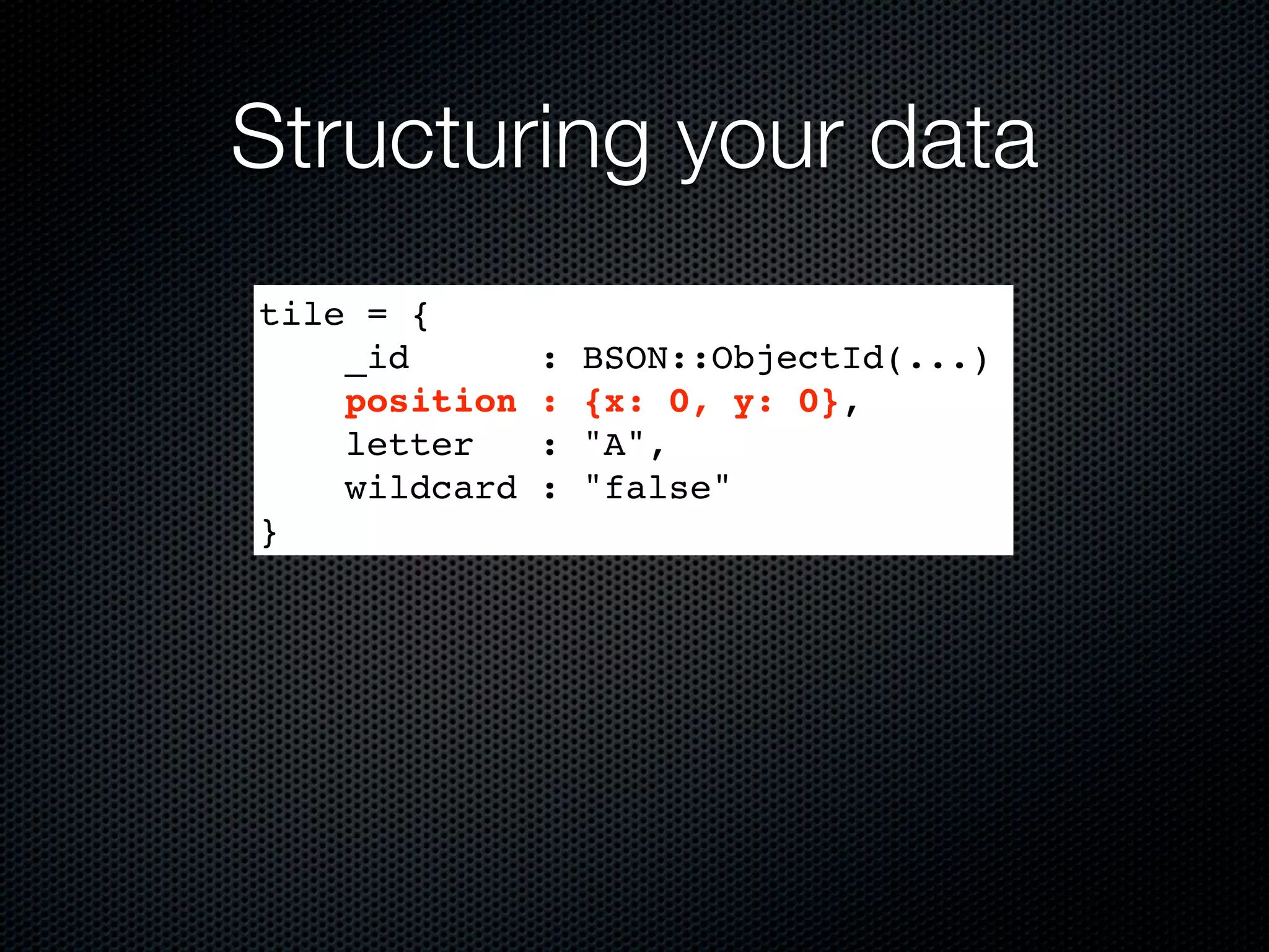
![Structuring your data
tile = {
_id : BSON::ObjectId(...)
position : [0,0],
letter : "A",
wildcard : "false"
}](https://image.slidesharecdn.com/gdconline2011-111015001035-phpapp01/75/Mapping-Flatland-Using-MongoDB-for-an-MMO-Crossword-Game-GDC-Online-2011-14-2048.jpg)
![Watch your language
> db[‘tiles’].insert({
position : {y: 50, x: 20},
letter : "A",
wildcard : "false"
})
=> BSON::ObjectId('4dd06d037a70183256000004')
> db.[‘tiles’].find_one()
=>
{"_id"=>BSON::ObjectId('4dd06d037a70183256000
004'), "letter"=>"A", "position"=>{"x"=>20,
"y"=>50}, "wildcard"=>false}](https://image.slidesharecdn.com/gdconline2011-111015001035-phpapp01/75/Mapping-Flatland-Using-MongoDB-for-an-MMO-Crossword-Game-GDC-Online-2011-16-2048.jpg)
![Creating the index
> db[‘tiles’].create_index([[“position”,
Mongo::GEO2D]])
=> “position_2d”
> db[‘tiles’].index_information
=> {"_id_"=>{"name"=>"_id_",
"ns"=>"test.test_tiles", "key"=>{"_id"=>1}},
"position_2d"=>{"key"=>{"position"=>"2d"},
"ns"=>"test.test_tiles", "name"=>"position_2d"}}
Defaults:
Min: -180, Max: 180,
bits: 26](https://image.slidesharecdn.com/gdconline2011-111015001035-phpapp01/75/Mapping-Flatland-Using-MongoDB-for-an-MMO-Crossword-Game-GDC-Online-2011-18-2048.jpg)
![Creating the index
> db[‘tiles’].create_index(
[[“position”, Mongo::GEO2D]],
:min => -500, :max => 500, :bits => 32
)
=> “position_2d”](https://image.slidesharecdn.com/gdconline2011-111015001035-phpapp01/75/Mapping-Flatland-Using-MongoDB-for-an-MMO-Crossword-Game-GDC-Online-2011-19-2048.jpg)
![More index fun
Only one Geo2D index per collection (SERVER-2331)
But it can be a compound index:
> db[‘tiles’].create_index([
[“position”, Mongo::GEO2D],
[“letter”, Mongo::ASCENDING]
])
=> “position_2d_letter_1”
Queries are prefix-matched on indexes, so put Geo2D
first (or use hinting)](https://image.slidesharecdn.com/gdconline2011-111015001035-phpapp01/75/Mapping-Flatland-Using-MongoDB-for-an-MMO-Crossword-Game-GDC-Online-2011-20-2048.jpg)
![New 2.0 feature
Geo2d indices across an array field!
> db[‘words’].insert({
“word” : “QI”,
“tiles” : [
{“letter” => “Q”, position => [1,1]},
{“letter” => “I”, position => [2,1]}
]
})
=> BSON::ObjectID('4dd074927a70183256000006')
> db[‘words’].create_index([[
“tiles.position”,
Mongo::GEO2D
]])
=> “position_2d”](https://image.slidesharecdn.com/gdconline2011-111015001035-phpapp01/75/Mapping-Flatland-Using-MongoDB-for-an-MMO-Crossword-Game-GDC-Online-2011-21-2048.jpg)
![Querying real location data
Search by proximity: $near
Uses native units (degrees for [-180, 180])
Use $maxDistance to bound query
> db[‘tile’].find(:position => {“$near” => [10,10]}).to_a
=> [{"_id"=>BSON::ObjectId('4dd084ca7a70183256000007'),
"letter"=>"A", "position"=>[12,9]}]
> db[‘tile’].find(:position => {“$near” => [10,10],
“$maxDistance” => 1}).to_a
=>[]](https://image.slidesharecdn.com/gdconline2011-111015001035-phpapp01/75/Mapping-Flatland-Using-MongoDB-for-an-MMO-Crossword-Game-GDC-Online-2011-26-2048.jpg)
![Querying real location data
Need distance to center as well? Use $geoNear
Also includes fun stats
> db.command('geoNear' => 'tiles', 'near' => [1830,
2002], :maxDistance => 10)
)
=> {"ns"=>"test.tiles",
"near"=>"110000000000001100011000110010101010001000001011
1111", "results"=>[{"dis"=>3.999471664428711,
"obj"=>{"_id"=>BSON::ObjectId('4dd0b0957a701852bc02bf67')
, "position"=>{"x"=>1830, "y"=>2006}, "letter"=>"A"}}],
"stats"=>{"time"=>0, "btreelocs"=>3, "nscanned"=>2,
"objectsLoaded"=>1, "avgDistance"=>3.999471664428711,
"maxDistance"=>3.999471664428711}, "ok"=>1.0}](https://image.slidesharecdn.com/gdconline2011-111015001035-phpapp01/75/Mapping-Flatland-Using-MongoDB-for-an-MMO-Crossword-Game-GDC-Online-2011-27-2048.jpg)
![Querying real location data
Region queries: $within
Example: $box (rectangle)
> db[‘tile’].find(:position => {“$within” => {“$box” =>
[[10,10], [30,30]]}).to_a
=> [{"_id"=>BSON::ObjectId('4dd084ca7a70183256000007'),
"letter"=>"A", "position"=>[12,9]}]
[30,30]
[10,10]](https://image.slidesharecdn.com/gdconline2011-111015001035-phpapp01/75/Mapping-Flatland-Using-MongoDB-for-an-MMO-Crossword-Game-GDC-Online-2011-28-2048.jpg)
![Querying real location data
Alternately: $center (circle)
> db[‘tile’].find(:position => {“$within” => {“$center”
=> [[10,10], 5]}).to_a
=> [{"_id"=>BSON::ObjectId('4dd084ca7a70183256000007'),
"letter"=>"A", "position"=>[12,9]}]
5
[10,10]](https://image.slidesharecdn.com/gdconline2011-111015001035-phpapp01/75/Mapping-Flatland-Using-MongoDB-for-an-MMO-Crossword-Game-GDC-Online-2011-29-2048.jpg)
![Querying real location data
New in 2.0: $polygon!
> db[‘tile’].find(:position => {“$within” => {“$polygon”
=> [[5,5], [5,15], [15,5]}).to_a
=> [{"_id"=>BSON::ObjectId('4dd084ca7a70183256000007'),
"letter"=>"A", "position"=>[12,9]}]
[5,15]
[5,5] [15,5]](https://image.slidesharecdn.com/gdconline2011-111015001035-phpapp01/75/Mapping-Flatland-Using-MongoDB-for-an-MMO-Crossword-Game-GDC-Online-2011-30-2048.jpg)
![Querying real location data
Spherical equivalents: $nearSphere and $centerSphere
Uses radians, not native units
position must be in [long, lat] order!
> earthRadius = 6378 #km
=> 6378
> db[‘restaurants’].find(:position => {“$nearSphere” =>
[-122.03,36.97], “$maxDistance” => 25.0/earthRadius}).to_a
=> [{"_id"=>BSON::ObjectId('4dd084ca7a70183256000007'),
"name"=>"Crow’s Nest", "position"=>[-122.0,36.96]}]](https://image.slidesharecdn.com/gdconline2011-111015001035-phpapp01/75/Mapping-Flatland-Using-MongoDB-for-an-MMO-Crossword-Game-GDC-Online-2011-31-2048.jpg)
![Gotchas
-1,1 0,1 1,1 2,1
-2,0 -1,0 0,0 1,0 2,0
-1,-1 0,-1 1,-1 2,-1
Non-uniform distances between adjacent ranks
Example: $within => [-1,-1], [1,1]](https://image.slidesharecdn.com/gdconline2011-111015001035-phpapp01/75/Mapping-Flatland-Using-MongoDB-for-an-MMO-Crossword-Game-GDC-Online-2011-37-2048.jpg)
![Gotchas
-1,1 0,1 1,1 2,1
-2,0 -1,0 0,0 1,0 2,0
-1,-1 0,-1 1,-1 2,-1
Non-uniform distances between adjacent ranks
Example: $within => [-1,-1], [1,1]](https://image.slidesharecdn.com/gdconline2011-111015001035-phpapp01/75/Mapping-Flatland-Using-MongoDB-for-an-MMO-Crossword-Game-GDC-Online-2011-38-2048.jpg)
![Gotchas
-1,1 0,1 1,1 2,1
-2,0 -1,0 0,0 1,0 2,0
-1,-1 0,-1 1,-1 2,-1
Oops.
Non-uniform distances between adjacent ranks
Example: $within => [-1,-1], [1,1]](https://image.slidesharecdn.com/gdconline2011-111015001035-phpapp01/75/Mapping-Flatland-Using-MongoDB-for-an-MMO-Crossword-Game-GDC-Online-2011-39-2048.jpg)


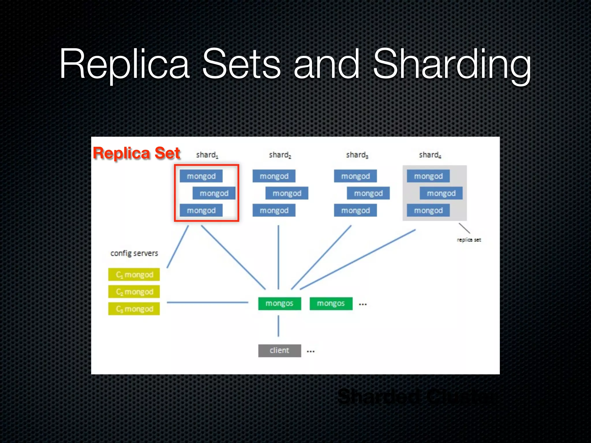
The document provides an overview of using MongoDB for storing and querying geospatial data, detailing its features including geospatial indexing and querying capabilities. It discusses data structuring, indexing methods, and various querying techniques such as proximity searches and region queries, offering MongoDB commands and examples throughout. Additionally, it addresses challenges and limitations associated with geospatial queries and mentions scaling options like sharding.