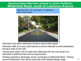
Public Information Centre
May 26, 2016
Lawrence Park Community Church, 2180 Bayview Avenue
Lawrence Park Neighbourhood Investigation of
Basement Flooding &
Road Improvement Study
2
Why are we doing this study?
The City has an obligation to ensure that its infrastructure is in a state of good
repair and, when reconstructed, is brought up to date to meet today’s policies and
standards.
We must address these infrastructure problems:
• Deteriorated Road Infrastructure
• Pedestrian Safety
• Traffic Management
• Poor Road Drainage
• Incidences of Basement Flooding
3
Problem: Deteriorated Roads
• Many roads require full reconstruction; built over 50 years ago and are at
the end of their service life
Graphic summarizes results of 2013 geotechnical
assessment of pavement conditions.
4
• To improve underlying
pavement structure
deterioration
• To correct major road
drainage problems
• To change the layout of the
existing road features (i.e.,
width or location of road
surface, curbs or sidewalks)
Resurfacing vs. Reconstruction
• Recent resurfacing is only a temporary solution. It is not a cost-effective, long-
term solution for the road structure or drainage of the roads
• With maintenance and rehabilitation, reconstructed roads will last up to 100
years
• Reconstruction is required:
5
Problem: Pedestrian Safety
• Sidewalks exist on west-side of the neighbourhood; no pedestrian
connection to east-side
• Vehicle and pedestrian conflicts
• Busiest street - Mildenhall Road provides only a 1.2m asphalt path
with no separation from traffic
6
Problem: Traffic Management
• Concerns with intersection sight-lines and traffic infiltration
• Concerns with speeding can be addressed through road narrowing,
traffic calming and enforcement
• Traffic Calming is a separate process and can be requested by residents
or Councillor and is managed outside of the Environmental Assessment
• Toronto’s traffic calming policy requires a sidewalk on the street
7
Problem: Poor Road Drainage
• Swales have been filled-in or landscaped
• As a result surface water (or road drainage) does not drain and
causes excessive ponding on streets and private property
8
Problem: Basement Flooding
• Sewer back-ups have been reported during severe rainstorm events
• Storm drainage system in East-side (former North York) is not functioning
during severe storm events, and is backing up in the sanitary sewers
• Sewer system in West-side (former Toronto) is sized to handle the
average rainfall, not severe storm events
9
What is the study process?
To address the infrastructure problems, the City is carrying out a Master Plan
study under the Municipal Class Environmental Assessment (a prescribed
process to meet the requirements of the province’s Environmental Assessment Act).
An EA assesses impacts on all aspects of the environment, the community and
stakeholders, and produces recommendations based on a logical decision making
process.
10
Three Stages – Study, Design, Construction
Environmental Assessment Study
Establish framework of road widths, streets with sidewalks, road
drainage system, sewer improvements and traffic sight-lines
Detailed Engineering Design
Produce detailed drawings with:
• Road alignment
• Sidewalk and curb details (side of street, material)
• Incorporate locations of other utilities (e.g., hydro, gas)
• Coordinate other necessary upgrades (e.g., watermains, sanitary
sewers)
Construction
Qualified contractor hired to carry out construction;
City oversees contract and inspection of work
11
22
33
11
What we’ve heard
• Study area streets
• Preserving trees is a key priority
• Desire to maintain rural, unique character
• Mixed views on sidewalks
• Traffic safety
• General agreement with traffic safety recommendations
• Support for more traffic safety measures (parking restrictions,
sight line improvements, signs and turning restrictions)
• Basement flooding
• General agreement that sewer upgrades needed to reduce
basement flooding risk
• Some concern over potential implications of solutions (e.g., loss
of trees, more paved surfaces)
• Request to extend sewer improvements to additional streets
12
Infrastructure Standards
Standards and Policies Study Considerations for Lawrence Park
Local Road - 8.5 m road width 7.2 m road width with localized narrowing to 6.6 m
Local Road - 1.7- 2.0 m sidewalk on
one or both sides
Inclusion of a sidewalk on one side was evaluated.
1.5 m sidewalk on local roads that create or maintain a key
linkage across the neighbourhood.
Collector Road - 9.5 m road width
1.7- 2.0 m sidewalk on both sides
8.5 m road width, 1.5 m sidewalk on one side
7.2 m road width, 1.5 m sidewalk on both sides
Maintain existing ditches Ditches and underground storm sewers evaluated. Storm sewers
score higher because of significant tree loss associated with
rebuilding ditches to standard.
Enhanced level of protection against sanitary sewer back-up for 25-50 year storm event and storm sewer
back-up and surface flooding for 100-year storm event
*Management of runoff on or between private property is the responsibility of the homeowners
City standards and policies have been reviewed and consideration has been given to the
study area conditions, and public and stakeholder feedback.
The EA report will capture the area specific considerations and will be a guide during the
design work that will follow.
13
Assessment of Tree Impacts
1
Assessment of Tree Impacts
 
Not Impacted: The TIZ lies completely outside of the construction width and will
not be impacted.
  Preserved if Possible: Construction inside the TIZ; the tree will be impacted by
construction. Design, construction and post construction mitigation techniques
will be used to preserve the tree.
 
Removed and Replaced: Construction significantly inside the TIZ. Tree
significantly impacted by construction to the extent that removal is expected.
• During an EA study a worst case assessment of tree impacts is undertaken
• Hearing the community concern, a more detailed level of effort was conducted in
Lawrence Park Neighbourhood to better define and minimize the impacts
• Each tree was assessed individually for a customized Tree Impact Zone (TIZ) - red
circles in drawing)
15
Caring for Trees during Construction
Pictured above: Pneumatic (air) and hydraulic (water) excavation techniques
remove the surrounding soil without significantly damaging tree roots.
Photo: Ruskins.co.uk
Photo: djc.com
Photo: T-Rex Services
Construction Stage
• On-site supervision by certified arborists and communication plan
• Excavation techniques (hand excavation, pneumatic, hydraulic, etc.)
• Root pruning techniques and considerations
• Backfill techniques and considerations
• Tree care during construction
Photo: gibneye.com
16
Post-Construction Care
Photo: greentreedoctor.comPhoto: selector.com
Photo: thinktrees.co.uk
Monitoring Irrigation Aeration
Post-Construction
• Monitoring
• Irrigation
• Aeration
• Mulching
• Wound treatment, as necessary
• Fertilization (not recommended for at least 1 year post construction)
17
Tree Summary
Table shows the current count of trees estimated to be removed and replaced,
preserved if possible and not impacted based on customized Tree Impact Zone
assessments.
18
Adding to the Tree Canopy
• The City will plant new trees as early as this year
• The City will identify potential locations and species type, and will consult
with affected property owners
• Overall tree canopy can increase by over a 100 trees
• Early planting will allow trees to become established well ahead of
construction
• During construction, the City will replace each tree that is removed
New Trees
Replacement Trees
19
Tree Assessment Example
Wood Avenue
 
Not Impacted
 
Preserved if Possible
 
Removed and Replaced
20
Before and After Illustration
Existing Conditions
• Pavement width (asphalt) – 6.8 m
• Roadway width – 8.2 m
• Swales/culverts on both sides
Post Construction
• Proposed Pavement width – 7.2 m
• Proposed Roadway width – 7.6 m
Features include:
Addition of curbs and storm sewer/catch
basins within roadway
Wood Avenue
21
Tree Assessment Example
Buckingham Avenue
 
Not Impacted
 
Preserved if Possible
 
Removed and Replaced
22
Before and After Illustration
Existing Conditions
• Pavement width (asphalt) – 7.4 m
• Roadway width – 8.2 m
• Swales/culverts on both sides
Post Construction
• Proposed Pavement width – 7.2 m
• Proposed Roadway width – 7.6 m
Features include:
Addition of curbs and storm sewer/catch
basins within roadway
Buckingham Avenue
23
Tree Assessment Example
St. Leonards Avenue
 
Not Impacted
 
Preserved if Possible
 
Removed and Replaced
24
Before and After Illustration
Existing Conditions
• Pavement width (asphalt) – 7.0 m
• Roadway width – 9.2 m
• Swales/culverts on both sides
Post Construction
• Pavement width – 7.2 m
• Roadway width – 9.1 m
Features to include:
Addition of one sidewalk, curbs and
storm sewer/catchbasins within roadway
(note: sidewalk on right-side for illustration
purpose only)
St. Leonards Avenue
25
Reducing Tree Impacts & Removals
We will continue to find opportunities to reduce tree impacts and removals
Design Stage
• Narrowing sections of local roads to 6.6 metres
• Shifting road alignment
• Detail tree removals and retentions on plan drawings
• Plan areas for construction access, staging, material storage
• Examine tunneling vs trenching, grade changes, slope stabilization, etc.
…
Construction Stage
• Tree impact zone (TIZ) fencing and signage, trunk protection, etc.
• Examine considerations for root and crown pruning to avoid damage by construction
equipment
• On-site supervision by certified arborists and communication plan
26
Localized Road Narrowing
Illustrates road narrowing to 6.6 m to reduce impact on
trees. Parking would not be allowed within narrowed
section of road.
27
Localized Road Narrowing
Existing Road
Road narrowed to 6.6 m
Preserved
Trees
Preliminary Alignment
Narrowed Alignment
28
Localized Shifting of Road
Illustrates road shifting north to avoid removal of trees
29
Localized Shifting of Road
Existing Conditions
Preserved
Trees
Road
Shifted
Preliminary Alignment
Shifted Alignment
30
Roads, Sidewalks and Drainage
31
Road Reconstruction
• Full depth reconstruction required for 26 roads in the study area due
to deteriorated road conditions
• For each road, the City must address varying road width, pedestrian
access and road drainage
• Based on review of City policies/standards and characteristics of the
study area, the following set of alternative options were evaluated:
• Sidewalk width of 1.5 m, which is the provincial minimum
Local Road Width 8.5 m or 7.2 m
Collector Road Width
(Mildenhall South)
9.5 m, 8.5 m or 7.2 m
Sidewalks Local Road - 0 or 1 sidewalk
Collector Road - 1 or 2 sidewalks
Road Drainage Urban (storm sewers + catch basins)
Rural (ditches)
32
Urban Road Drainage
• Urban road drainage will result in the fewest impacts to trees as the
sewer is located under the road surface
• Storm sewers will have perforated pipes to allow storm water to
naturally infiltrate into soil
• At time of construction, existing swales will be filled-in and landscaped
33
Sidewalks
• In review of the study area characteristics, City has examined creating
pedestrian linkages to key destinations in the neighbourhood (schools,
church, nursery, TTC stops) and connecting existing sidewalks
• Sidewalks are recommended for 5 out of 26 roads
• Mildenhall Road South: Safer and accessible connection along street with
high traffic volumes
• St. Leonards Ave & Dawlish Ave: Adds west-east connectors to Bayview
Avenue
• Glenallen Rd & Pinedale Rd: Safer connection to local school
• Sidewalks will run alongside the road curb; location (side of street) to be
determined during detailed design stage
• City’s new Green Standards may provide alternative sidewalk materials
• Recommendations will help improve accessibility in the neighbourhood
34
7.2 metre road + 1 sidewalk +
urban cross section
Recommended Alternative Solutions:
LOCAL ROAD
7.2 metre road + urban cross section
Parking on 7.2 m road width will be limited to one side of road; where road is
narrowed to 6.6 m parking will not be allowed
35
•Six alternatives were evaluated; Alternative #5 scored highest and was presented at
third PIC (May 2015) as recommended alternative
•We heard concerns from the public about safety and traffic speed and request for a
narrower road
•This alternative was reconsidered and is not being recommended
Previously Recommended Alternative (since revised):
Mildenhall Road, south of Lawrence Avenue
Alternative #5: 8.5m road + 1 sidewalk + urban
cross section
36
Alternative #6: 7.2m road width + 2 sidewalks +
urban cross section
•Narrower road option addresses concerns about traffic speed
•Narrower width on a busy road requires a second sidewalk to avoid pedestrians
having to walk on the road
•Construction width is 20 cm wider than Alternative #5; this may result in an
estimated 3 additional tree removal requirements
•Parking restrictions will largely remain unchanged on Mildenhall Road. Parking
around Cheltenham Park will be examined at the detailed design stage.
Recommended Alternative (based on public feedback):
Mildenhall Road, south of Lawrence Avenue
37
Study Recommendations
Legend
7.2 m width, 1 sidewalk,
urban cross section
7.2 m width, no sidewalk,
urban cross section
7.2 m width, 2 sidewalk,
urban cross section
38
Traffic Management
39
Traffic Management
• Findings for area bound by Mt. Pleasant / Bayview / Blythwood / Lawrence
Avenue show traffic volumes within City standards of:
• < 2500 vehicles per day (local road) and,
• 2500-8000 vehicles per day (collector road) Blythwood Road at Strathgowan Cres,
facing East
• Recommendations include addressing
sightline issues at 3 locations:
• Remove or relocate stone wall at
Blythwood Road / Strathgowan Crescent
• Trimming of tree branches at
Mount Pleasant Road / Lawrence Crescent
and Mount Pleasant Road / St. Leonards
Avenue
• Requests for a stop sign at Dawlish Ave and Mildenhall Road reviewed
• Analysis shows a potential decrease in angled collisions but an increase in rear-
end collisions
• Staff will review sightlines at intersection for further action
• Staff will continue to work with the Toronto French School to identify further
improvements that can be made
40
Basement Flooding
41
Addressing Basement Flooding
• Two separate areas based on former municipalities
• West-side (former Toronto)
• Combined sewers
• Storm sewers convey road drainage
• East-side (former North York)
• Sanitary sewers
• Swales and a partial storm sewer system convey road drainage
• Data from field surveys, soil conditions, sewer flow monitoring and
questionnaires were collected and reviewed
• A hydrologic-hydraulic computer model created to analyze operation of
sewer systems under different rainstorm conditions
• Model shows the risks based on the ability of sewers to convey flows
without flooding basements
• Surface ponding addressed as part of road reconstruction work
42
West-side (former Toronto)
•Additional capacity needed in the
combined sewer to reduce
basement flooding risks
•Storm sewers to be added on St.
Leonards Ave, Glengowan Rd., &
Dundurn Rd. to capture and
convey road drainage will reduce
flow into the combined sewer
Basement Flooding Protection – West-side
43
East-side (former North York)
• Additional capacity needed in
the sanitary sewer system to
reduce basement flooding
risks
• Existing sanitary sewers on
Rochester Ave., Bayview Ave.,
Wood Ave., Bayview Wood,
and Valleyanna Dr. to be
enlarged
• Underground storage tank to
be constructed within the road
on Valleyanna Dr.
• Sanitary manholes to be
sealed in low lying areas
Basement Flooding – East-side
44
Reducing Your Risks of Flooding
• Downspout disconnection can help us to reduce the amount of
water entering the sewer system
• City has implemented a bylaw requiring owners to disconnect
downspouts, where feasible
• Homeowners can take other steps on private property to help
reduce the chances of basement flooding
• Seal cracks or openings in walls, floors, windows
and foundations, and seal all window wells
• Clear eavestroughs and downspouts of leaves
• Proper grading around home
• Increase green space around your home to help
absorb rainwater and melted snow
• Repair/replace damaged weeping tile systems
• Install a backwater valve and sump pump
45
SCHEDULE OF WORK
• All infrastructure work will be designed and constructed
based on Priority, Coordination and Funding
• Earliest start for detailed design is 2019-2020, construction
following approximately 1 year later
• Projects will be scheduled based on priority and technical
sequencing requirements
• Projects to be sequenced for construction over a 10-year
period
• City is committed to working with
community to engage and consult
with residents on design details
and construction
46
NEXT STEPS
• Once study is completed, City will report to
Committee of Council for approval of study
recommendations
• If approved, a study report will be published
and made available on-line for a 30-day public
review period
• During the 30-day review period, a resident
can contact the City to resolve any outstanding
issues, if the issue cannot be resolved, the
resident can request Minister of Environment &
Climate Change to review and make decision
47
THANK YOU AND QUESTIONS

Lawrence Park PIC 3 slides

  • 1.
    Public Information Centre May26, 2016 Lawrence Park Community Church, 2180 Bayview Avenue Lawrence Park Neighbourhood Investigation of Basement Flooding & Road Improvement Study
  • 2.
    2 Why are wedoing this study? The City has an obligation to ensure that its infrastructure is in a state of good repair and, when reconstructed, is brought up to date to meet today’s policies and standards. We must address these infrastructure problems: • Deteriorated Road Infrastructure • Pedestrian Safety • Traffic Management • Poor Road Drainage • Incidences of Basement Flooding
  • 3.
    3 Problem: Deteriorated Roads •Many roads require full reconstruction; built over 50 years ago and are at the end of their service life Graphic summarizes results of 2013 geotechnical assessment of pavement conditions.
  • 4.
    4 • To improveunderlying pavement structure deterioration • To correct major road drainage problems • To change the layout of the existing road features (i.e., width or location of road surface, curbs or sidewalks) Resurfacing vs. Reconstruction • Recent resurfacing is only a temporary solution. It is not a cost-effective, long- term solution for the road structure or drainage of the roads • With maintenance and rehabilitation, reconstructed roads will last up to 100 years • Reconstruction is required:
  • 5.
    5 Problem: Pedestrian Safety •Sidewalks exist on west-side of the neighbourhood; no pedestrian connection to east-side • Vehicle and pedestrian conflicts • Busiest street - Mildenhall Road provides only a 1.2m asphalt path with no separation from traffic
  • 6.
    6 Problem: Traffic Management •Concerns with intersection sight-lines and traffic infiltration • Concerns with speeding can be addressed through road narrowing, traffic calming and enforcement • Traffic Calming is a separate process and can be requested by residents or Councillor and is managed outside of the Environmental Assessment • Toronto’s traffic calming policy requires a sidewalk on the street
  • 7.
    7 Problem: Poor RoadDrainage • Swales have been filled-in or landscaped • As a result surface water (or road drainage) does not drain and causes excessive ponding on streets and private property
  • 8.
    8 Problem: Basement Flooding •Sewer back-ups have been reported during severe rainstorm events • Storm drainage system in East-side (former North York) is not functioning during severe storm events, and is backing up in the sanitary sewers • Sewer system in West-side (former Toronto) is sized to handle the average rainfall, not severe storm events
  • 9.
    9 What is thestudy process? To address the infrastructure problems, the City is carrying out a Master Plan study under the Municipal Class Environmental Assessment (a prescribed process to meet the requirements of the province’s Environmental Assessment Act). An EA assesses impacts on all aspects of the environment, the community and stakeholders, and produces recommendations based on a logical decision making process.
  • 10.
    10 Three Stages –Study, Design, Construction Environmental Assessment Study Establish framework of road widths, streets with sidewalks, road drainage system, sewer improvements and traffic sight-lines Detailed Engineering Design Produce detailed drawings with: • Road alignment • Sidewalk and curb details (side of street, material) • Incorporate locations of other utilities (e.g., hydro, gas) • Coordinate other necessary upgrades (e.g., watermains, sanitary sewers) Construction Qualified contractor hired to carry out construction; City oversees contract and inspection of work 11 22 33
  • 11.
    11 What we’ve heard •Study area streets • Preserving trees is a key priority • Desire to maintain rural, unique character • Mixed views on sidewalks • Traffic safety • General agreement with traffic safety recommendations • Support for more traffic safety measures (parking restrictions, sight line improvements, signs and turning restrictions) • Basement flooding • General agreement that sewer upgrades needed to reduce basement flooding risk • Some concern over potential implications of solutions (e.g., loss of trees, more paved surfaces) • Request to extend sewer improvements to additional streets
  • 12.
    12 Infrastructure Standards Standards andPolicies Study Considerations for Lawrence Park Local Road - 8.5 m road width 7.2 m road width with localized narrowing to 6.6 m Local Road - 1.7- 2.0 m sidewalk on one or both sides Inclusion of a sidewalk on one side was evaluated. 1.5 m sidewalk on local roads that create or maintain a key linkage across the neighbourhood. Collector Road - 9.5 m road width 1.7- 2.0 m sidewalk on both sides 8.5 m road width, 1.5 m sidewalk on one side 7.2 m road width, 1.5 m sidewalk on both sides Maintain existing ditches Ditches and underground storm sewers evaluated. Storm sewers score higher because of significant tree loss associated with rebuilding ditches to standard. Enhanced level of protection against sanitary sewer back-up for 25-50 year storm event and storm sewer back-up and surface flooding for 100-year storm event *Management of runoff on or between private property is the responsibility of the homeowners City standards and policies have been reviewed and consideration has been given to the study area conditions, and public and stakeholder feedback. The EA report will capture the area specific considerations and will be a guide during the design work that will follow.
  • 13.
  • 14.
    1 Assessment of TreeImpacts   Not Impacted: The TIZ lies completely outside of the construction width and will not be impacted.   Preserved if Possible: Construction inside the TIZ; the tree will be impacted by construction. Design, construction and post construction mitigation techniques will be used to preserve the tree.   Removed and Replaced: Construction significantly inside the TIZ. Tree significantly impacted by construction to the extent that removal is expected. • During an EA study a worst case assessment of tree impacts is undertaken • Hearing the community concern, a more detailed level of effort was conducted in Lawrence Park Neighbourhood to better define and minimize the impacts • Each tree was assessed individually for a customized Tree Impact Zone (TIZ) - red circles in drawing)
  • 15.
    15 Caring for Treesduring Construction Pictured above: Pneumatic (air) and hydraulic (water) excavation techniques remove the surrounding soil without significantly damaging tree roots. Photo: Ruskins.co.uk Photo: djc.com Photo: T-Rex Services Construction Stage • On-site supervision by certified arborists and communication plan • Excavation techniques (hand excavation, pneumatic, hydraulic, etc.) • Root pruning techniques and considerations • Backfill techniques and considerations • Tree care during construction Photo: gibneye.com
  • 16.
    16 Post-Construction Care Photo: greentreedoctor.comPhoto:selector.com Photo: thinktrees.co.uk Monitoring Irrigation Aeration Post-Construction • Monitoring • Irrigation • Aeration • Mulching • Wound treatment, as necessary • Fertilization (not recommended for at least 1 year post construction)
  • 17.
    17 Tree Summary Table showsthe current count of trees estimated to be removed and replaced, preserved if possible and not impacted based on customized Tree Impact Zone assessments.
  • 18.
    18 Adding to theTree Canopy • The City will plant new trees as early as this year • The City will identify potential locations and species type, and will consult with affected property owners • Overall tree canopy can increase by over a 100 trees • Early planting will allow trees to become established well ahead of construction • During construction, the City will replace each tree that is removed New Trees Replacement Trees
  • 19.
    19 Tree Assessment Example WoodAvenue   Not Impacted   Preserved if Possible   Removed and Replaced
  • 20.
    20 Before and AfterIllustration Existing Conditions • Pavement width (asphalt) – 6.8 m • Roadway width – 8.2 m • Swales/culverts on both sides Post Construction • Proposed Pavement width – 7.2 m • Proposed Roadway width – 7.6 m Features include: Addition of curbs and storm sewer/catch basins within roadway Wood Avenue
  • 21.
    21 Tree Assessment Example BuckinghamAvenue   Not Impacted   Preserved if Possible   Removed and Replaced
  • 22.
    22 Before and AfterIllustration Existing Conditions • Pavement width (asphalt) – 7.4 m • Roadway width – 8.2 m • Swales/culverts on both sides Post Construction • Proposed Pavement width – 7.2 m • Proposed Roadway width – 7.6 m Features include: Addition of curbs and storm sewer/catch basins within roadway Buckingham Avenue
  • 23.
    23 Tree Assessment Example St.Leonards Avenue   Not Impacted   Preserved if Possible   Removed and Replaced
  • 24.
    24 Before and AfterIllustration Existing Conditions • Pavement width (asphalt) – 7.0 m • Roadway width – 9.2 m • Swales/culverts on both sides Post Construction • Pavement width – 7.2 m • Roadway width – 9.1 m Features to include: Addition of one sidewalk, curbs and storm sewer/catchbasins within roadway (note: sidewalk on right-side for illustration purpose only) St. Leonards Avenue
  • 25.
    25 Reducing Tree Impacts& Removals We will continue to find opportunities to reduce tree impacts and removals Design Stage • Narrowing sections of local roads to 6.6 metres • Shifting road alignment • Detail tree removals and retentions on plan drawings • Plan areas for construction access, staging, material storage • Examine tunneling vs trenching, grade changes, slope stabilization, etc. … Construction Stage • Tree impact zone (TIZ) fencing and signage, trunk protection, etc. • Examine considerations for root and crown pruning to avoid damage by construction equipment • On-site supervision by certified arborists and communication plan
  • 26.
    26 Localized Road Narrowing Illustratesroad narrowing to 6.6 m to reduce impact on trees. Parking would not be allowed within narrowed section of road.
  • 27.
    27 Localized Road Narrowing ExistingRoad Road narrowed to 6.6 m Preserved Trees Preliminary Alignment Narrowed Alignment
  • 28.
    28 Localized Shifting ofRoad Illustrates road shifting north to avoid removal of trees
  • 29.
    29 Localized Shifting ofRoad Existing Conditions Preserved Trees Road Shifted Preliminary Alignment Shifted Alignment
  • 30.
  • 31.
    31 Road Reconstruction • Fulldepth reconstruction required for 26 roads in the study area due to deteriorated road conditions • For each road, the City must address varying road width, pedestrian access and road drainage • Based on review of City policies/standards and characteristics of the study area, the following set of alternative options were evaluated: • Sidewalk width of 1.5 m, which is the provincial minimum Local Road Width 8.5 m or 7.2 m Collector Road Width (Mildenhall South) 9.5 m, 8.5 m or 7.2 m Sidewalks Local Road - 0 or 1 sidewalk Collector Road - 1 or 2 sidewalks Road Drainage Urban (storm sewers + catch basins) Rural (ditches)
  • 32.
    32 Urban Road Drainage •Urban road drainage will result in the fewest impacts to trees as the sewer is located under the road surface • Storm sewers will have perforated pipes to allow storm water to naturally infiltrate into soil • At time of construction, existing swales will be filled-in and landscaped
  • 33.
    33 Sidewalks • In reviewof the study area characteristics, City has examined creating pedestrian linkages to key destinations in the neighbourhood (schools, church, nursery, TTC stops) and connecting existing sidewalks • Sidewalks are recommended for 5 out of 26 roads • Mildenhall Road South: Safer and accessible connection along street with high traffic volumes • St. Leonards Ave & Dawlish Ave: Adds west-east connectors to Bayview Avenue • Glenallen Rd & Pinedale Rd: Safer connection to local school • Sidewalks will run alongside the road curb; location (side of street) to be determined during detailed design stage • City’s new Green Standards may provide alternative sidewalk materials • Recommendations will help improve accessibility in the neighbourhood
  • 34.
    34 7.2 metre road+ 1 sidewalk + urban cross section Recommended Alternative Solutions: LOCAL ROAD 7.2 metre road + urban cross section Parking on 7.2 m road width will be limited to one side of road; where road is narrowed to 6.6 m parking will not be allowed
  • 35.
    35 •Six alternatives wereevaluated; Alternative #5 scored highest and was presented at third PIC (May 2015) as recommended alternative •We heard concerns from the public about safety and traffic speed and request for a narrower road •This alternative was reconsidered and is not being recommended Previously Recommended Alternative (since revised): Mildenhall Road, south of Lawrence Avenue Alternative #5: 8.5m road + 1 sidewalk + urban cross section
  • 36.
    36 Alternative #6: 7.2mroad width + 2 sidewalks + urban cross section •Narrower road option addresses concerns about traffic speed •Narrower width on a busy road requires a second sidewalk to avoid pedestrians having to walk on the road •Construction width is 20 cm wider than Alternative #5; this may result in an estimated 3 additional tree removal requirements •Parking restrictions will largely remain unchanged on Mildenhall Road. Parking around Cheltenham Park will be examined at the detailed design stage. Recommended Alternative (based on public feedback): Mildenhall Road, south of Lawrence Avenue
  • 37.
    37 Study Recommendations Legend 7.2 mwidth, 1 sidewalk, urban cross section 7.2 m width, no sidewalk, urban cross section 7.2 m width, 2 sidewalk, urban cross section
  • 38.
  • 39.
    39 Traffic Management • Findingsfor area bound by Mt. Pleasant / Bayview / Blythwood / Lawrence Avenue show traffic volumes within City standards of: • < 2500 vehicles per day (local road) and, • 2500-8000 vehicles per day (collector road) Blythwood Road at Strathgowan Cres, facing East • Recommendations include addressing sightline issues at 3 locations: • Remove or relocate stone wall at Blythwood Road / Strathgowan Crescent • Trimming of tree branches at Mount Pleasant Road / Lawrence Crescent and Mount Pleasant Road / St. Leonards Avenue • Requests for a stop sign at Dawlish Ave and Mildenhall Road reviewed • Analysis shows a potential decrease in angled collisions but an increase in rear- end collisions • Staff will review sightlines at intersection for further action • Staff will continue to work with the Toronto French School to identify further improvements that can be made
  • 40.
  • 41.
    41 Addressing Basement Flooding •Two separate areas based on former municipalities • West-side (former Toronto) • Combined sewers • Storm sewers convey road drainage • East-side (former North York) • Sanitary sewers • Swales and a partial storm sewer system convey road drainage • Data from field surveys, soil conditions, sewer flow monitoring and questionnaires were collected and reviewed • A hydrologic-hydraulic computer model created to analyze operation of sewer systems under different rainstorm conditions • Model shows the risks based on the ability of sewers to convey flows without flooding basements • Surface ponding addressed as part of road reconstruction work
  • 42.
    42 West-side (former Toronto) •Additionalcapacity needed in the combined sewer to reduce basement flooding risks •Storm sewers to be added on St. Leonards Ave, Glengowan Rd., & Dundurn Rd. to capture and convey road drainage will reduce flow into the combined sewer Basement Flooding Protection – West-side
  • 43.
    43 East-side (former NorthYork) • Additional capacity needed in the sanitary sewer system to reduce basement flooding risks • Existing sanitary sewers on Rochester Ave., Bayview Ave., Wood Ave., Bayview Wood, and Valleyanna Dr. to be enlarged • Underground storage tank to be constructed within the road on Valleyanna Dr. • Sanitary manholes to be sealed in low lying areas Basement Flooding – East-side
  • 44.
    44 Reducing Your Risksof Flooding • Downspout disconnection can help us to reduce the amount of water entering the sewer system • City has implemented a bylaw requiring owners to disconnect downspouts, where feasible • Homeowners can take other steps on private property to help reduce the chances of basement flooding • Seal cracks or openings in walls, floors, windows and foundations, and seal all window wells • Clear eavestroughs and downspouts of leaves • Proper grading around home • Increase green space around your home to help absorb rainwater and melted snow • Repair/replace damaged weeping tile systems • Install a backwater valve and sump pump
  • 45.
    45 SCHEDULE OF WORK •All infrastructure work will be designed and constructed based on Priority, Coordination and Funding • Earliest start for detailed design is 2019-2020, construction following approximately 1 year later • Projects will be scheduled based on priority and technical sequencing requirements • Projects to be sequenced for construction over a 10-year period • City is committed to working with community to engage and consult with residents on design details and construction
  • 46.
    46 NEXT STEPS • Oncestudy is completed, City will report to Committee of Council for approval of study recommendations • If approved, a study report will be published and made available on-line for a 30-day public review period • During the 30-day review period, a resident can contact the City to resolve any outstanding issues, if the issue cannot be resolved, the resident can request Minister of Environment & Climate Change to review and make decision
  • 47.