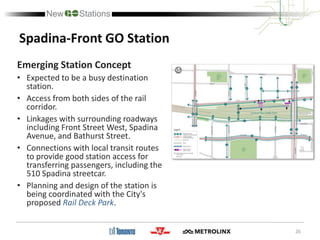
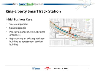
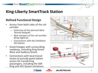
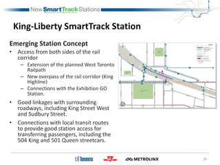
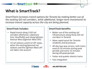
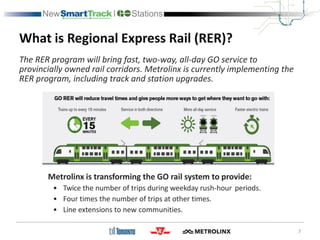
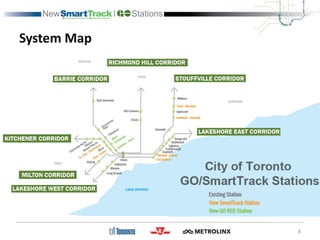
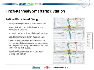
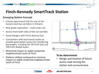
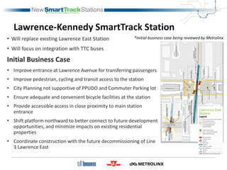
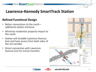
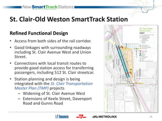
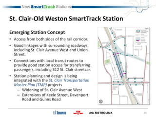
INew Stations
1
Public Meeting
Purpose of Today’s Meeting
 City, Metrolinx and TTC are working in partnership on
planning/design of 6 new SmartTrack and 2 new GO stations
in Toronto.
 This is the first round of Public and Stakeholder Consultation
for the new stations.
 Today, we will provide an overview of the station concept
schematics and environmental studies that are part of the
Transit Project Assessment Process for the stations.
 We would like your comments on the proposed approach -
such as opportunities that the new stations provide and how
the stations can be integrated within the local community.
2
Today’s Meeting Agenda
1. Project Overview – Background, Process and Timeline
2. Schematic Station Concepts
3. Questions / Discussion
3
Our Rapid Transit Network Today
4
Our Future Rapid Transit Network
5
What is SmartTrack?
SmartTrack includes:
• Rapid transit along 3 GO rail
corridors (Kitchener, Lakeshore
East, Stouffville) and along Eglinton
Avenue West (Eglinton West LRT)
• 14 rail stations and 8-12 LRT stops,
when the existing/planned rail
stations and the Eglinton West LRT
are taken into account
SmartTrack benefits:
• Better use of the existing rail
infrastructure along these GO rail
corridors in Toronto
• More rapid transit for Toronto
residents and businesses
• All-day two-way service, with trains
every 6-10 minutes during peak
periods and every 15 minutes
during off-peak periods
• Faster and quieter electric trains
• Fare integration
6
SmartTrack increases transit options for Toronto by making better use of
the existing GO rail corridors, while additional, longer-term investments to
increase transit capacity across the city are being planned.
What is Regional Express Rail (RER)?
7
The RER program will bring fast, two-way, all-day GO service to
provincially owned rail corridors. Metrolinx is currently implementing the
RER program, including track and station upgrades.
Metrolinx is transforming the GO rail system to provide:
• Twice the number of trips during weekday rush-hour periods.
• Four times the number of trips at other times.
• Line extensions to new communities.
System Map
8
Transit Project Assessment Process
The City and Metrolinx are
undertaking a Transit Project
Assessment Process (TPAP) under
Ontario Regulation 231/08 to assess
the potential environmental effects
of each of the new stations.
• Public and stakeholder consultation will be
an important component of this process.
• Existing environmental conditions will be
determined and the significance of
specific features will be evaluated.
• Potential impacts of the project on these
features will be identified and
documented.
• Appropriate mitigation measures,
monitoring strategies and future studies
will be recommended.
9
Early 2018
On-going
Fall 2017
Mid 2018
Late 2018
Station Planning and Design
Document Existing Conditions
Assessment Potential Impacts
Public and Stakeholder Consultation
City Council authorization to advance
Public and Stakeholder Consultation
City Council authorization to advance
TPAP Notice of Commencement
Public and Stakeholder Consultation
TPAP Notice of Completion
RFP for Procurement
WE ARE
HERE
New SmartTrack and GO Stations in Toronto
10
• The new SmartTrack/
GO stations build upon
the RER program.
• Within Toronto, 6 new
SmartTrack stations
are planned for the
Stouffville/Lakeshore
East and Kitchener GO
rail corridors and 2 new
GO stations are
planned for the Barrie
GO rail corridor.
Overview of Station Schematics
Station Planning Considerations:
• Platform and station access locations
• Connectivity with TTC surface transit routes
• Accessible transit pick up/drop off
• Pedestrian and cyclist access and local
circulation
• Coordination with related studies and potential
infrastructure improvements, for example:
11
– East Harbour Station with the Unilever Precinct Planning Study
– East Harbour and Gerrard-Carlaw Stations with the Relief Line Project Assessment
– St.Clair-Old Weston Station with St. Clair Transportation Master Plan
– Bloor-Lansdowne Station and King-Liberty with West Toronto Railpath extensions
– Lawrence-Kennedy and Finch-Kennedy stations with Scarborough Subway Extension
– Rail Deck Park at Spadina-Front Station
• Partnerships and property impacts for station elements and opportunities for
integrated station development
existing/planned
stations
Finch-Kennedy SmartTrack Station
• Will focus on integration with TTC buses
Initial Business Case
• Station design needs to be coordinated with the
Finch Avenue grade separation
• Ensure high-quality entrance at Finch Avenue for
transferring passengers
– Provide direct connection to surface transit routes
– Refine number and location of bus bays
• Improve pedestrian, cycling and transit access to the
station
• City Planning not supportive of PPUDO and
Commuter Parking lot
• Provide adequate and convenient bicycle facilities at
the station
• Provide accessible access in close proximity to station
entrance
• Determine location for access roads serving the
station and surrounding area
12
Finch-Kennedy SmartTrack Station
Refined Functional Design
• New grade separation – road under rail.
• Direct link for one of the busiest bus
corridors in Ontario.
• Access from both sides of the rail corridor.
• Good linkages with Finch Avenue East.
• Connections with local transit routes to
provide good station access for transferring
passengers, including the 39 Finch East and
199 Finch Rocket buses.
• Need and location for an access road
serving the station
13
Finch-Kennedy SmartTrack Station
Emerging Station Concept
• Critical rapid transit link for one of the
busiest local bus corridors in Ontario.
• New grade separation – road under rail.
• Access from both sides of the rail corridor.
• Good linkages with Finch Avenue East.
• Connections with local transit routes to
provide good station access for transferring
passengers, including the 39 Finch East and
199 Finch Rocket buses.
• Minimized impact on stable residential
neighbourhood south of Finch
• Platform shifted northward to minimize
impact on stable residential neighbourhood
south of Finch
14
To be determined:
• Design and location of future
access road serving the
station and surround area
Lawrence-Kennedy SmartTrack Station
• Will replace existing Lawrence East Station
• Will focus on integration with TTC buses
Initial Business Case
• Improve entrance at Lawrence Avenue for transferring passengers
• Improve pedestrian, cycling and transit access to the station
• City Planning not supportive of PPUDO and Commuter Parking lot
• Ensure adequate and convenient bicycle facilities at the station
• Provide accessible access in close proximity to main station
entrance
• Shift platform northward to better connect to future development
opportunities, and minimize impacts on existing residential
properties
• Coordinate construction with the future decommissioning of Line
3 Lawrence East
*Initial business case being reviewed by Metrolinx
Lawrence-Kennedy SmartTrack Station
Refined Functional Design
• Better connections to the north –
additional station entrance
• Minimize residential property impact to
the south
• Station will straddle Lawrence Avenue
East and have access from both sides of
the rail corridor.
• Direct connection with Lawrence
Avenue East for transit transfers
16
Lawrence-Kennedy SmartTrack Station
Emerging Station Concept
• Improved station access
• Minimize property impact
• Direct connection with Lawrence Avenue
East for transit transfers
To be determined:
1. Station Phasing with Line 3
2. Local Street Network
3. Integration with Development
17
Station is being reviewed by Metrolinx
Gerrard-Carlaw SmartTrack Station
Initial Business Case
• Platforms located between Logan
and Carlaw
• Entrances at either end of
platforms
• Bus Terminal
• Passenger pick-up and drop-off
facility
• Connection to Relief Line and 506
Streetcar
18
Gerrard-Carlaw SmartTrack Station
Refined Functional Design
• Platforms shifted north – between
Pape and Carlaw
• Access from both sides of the rail
corridor, with good linkages to
surrounding roadways including
Carlaw Street, Gerrard Street East
and Pape Avenue
• Improvements to the
pedestrian/cycling bridge at Pape
are being planned as part of
station
• Connections with local transit
routes to provide good station
access for transferring passengers
19
Gerrard-Carlaw SmartTrack Station
Emerging Station Concept
• Three station accesses with good
connections to Carlaw Street,
Gerrard Street East and Pape
Avenue
• Improvements to the
pedestrian/cycling bridge at Pape
are being planned as part of station
• Being planned as future interchange
station with Relief Line subway
• Connections are planned with local
transit routes to provide good
station access for transferring
passengers, including the 506
Carlton and 505 Dundas streetcars,
and the 72 Pape bus
20
Further consideration needed:
Location/design of accessible pick-
up and drop-off
East Harbour SmartTrack Station
Initial Business Case
• Integration with the
development of adjacent lands
• Rail corridor and bridge
expansion
• Flood protection and Don River
re-naturalization
• Good connection to Relief Line
and Broadview streetcar
extension
• Pedestrian and cycling
connections
• Coordination with Gardiner
Expressway reconfiguration
21
East Harbour SmartTrack Station
Refined Functional Design
• Planning and design of the station is
being integrated with the Unilever
Precinct Planning Study.
• Station will provide rapid transit
access to serve emerging major
employment node for 50,000+ new
jobs.
• The main station entrance will be
from Broadview Avenue extension,
including Broadview Streetcar.
• Station is being planned with excellent
connections to the proposed Relief
Line subway station at Broadview
Avenue and Eastern Avenue.
22
East Harbour SmartTrack Station
Emerging Station Concept
• Planning and design of the station is
being integrated with the Unilever
Precinct Planning Study.
• Station will provide rapid transit
access to serve emerging major
employment node for 50,000+ new
jobs.
• Multiple station entrances, including
from Broadview Avenue extension
and west side of Don River.
• Station is being planned with
excellent connections to the
proposed Relief Line subway station
at Broadview Avenue and Eastern
Avenue.
23
24
Spadina-Front GO Station
Initial Business Case
• Centre-platform serving Barrie
Corridor
• Two access points to Front
Street, including primary
entrance at Front and Spadina
• Potential for platform access
from Puente de Luz bridge
• Relocation of existing above
ground utilities
25
Spadina-Front GO Station
Refined Functional Design
• Expected to be a busy destination
station.
• Access from both sides of the rail
corridor.
• Linkages with surrounding roadways
including Front Street West, Spadina
Avenue, and Bathurst Street.
• Connections with local transit routes
to provide good station access for
transferring passengers, including the
510 Spadina streetcar.
• Planning and design of the station is
being coordinated with the City's
proposed Rail Deck Park.
26
Spadina-Front GO Station
Emerging Station Concept
• Expected to be a busy destination
station.
• Access from both sides of the rail
corridor.
• Linkages with surrounding roadways
including Front Street West, Spadina
Avenue, and Bathurst Street.
• Connections with local transit routes
to provide good station access for
transferring passengers, including the
510 Spadina streetcar.
• Planning and design of the station is
being coordinated with the City's
proposed Rail Deck Park.
King-Liberty SmartTrack Station
Initial Business Case
• Track realignment
• Signal upgrades
• Pedestrian and/or cycling bridges
or tunnels
• Repurposing an existing heritage
building as a passenger services
building
27
King-Liberty SmartTrack Station
Refined Functional Design
• Access from both sides of the rail
corridor
– Extension of the planned West
Toronto Railpath
– New overpass of the rail corridor
(King Highline)
– Connections with the Exhibition
GO Station.
• Good linkages with surrounding
roadways, including King Street
West and Sudbury Street.
• Connections with local transit
routes to provide good station
access for transferring
passengers, including the 504
King and 501 Queen streetcars.
28
29
King-Liberty SmartTrack Station
Emerging Station Concept
• Access from both sides of the rail
corridor
– Extension of the planned West Toronto
Railpath
– New overpass of the rail corridor (King
Highline)
– Connections with the Exhibition GO
Station.
• Good linkages with surrounding
roadways, including King Street West
and Sudbury Street.
• Connections with local transit routes
to provide good station access for
transferring passengers, including the
504 King and 501 Queen streetcars.
Bloor-Lansdowne GO Station
Initial Business Case
• Double tracking and track realignment
• Bloor St. bridge widening
• Minimum width edge platforms
• Pedestrian and cycling connections, including
north-south multi-use path
• Passenger pick-up and drop off on Value
Village site
30
31
Bloor-Lansdowne GO Station
Refined Functional Design
• Critical link between GO RER and the TTC Line
2 subway at Lansdowne Station
• Access from both sides of the rail corridor,
including extension of the Greenway Multi-
Use Path to connect with the West Toronto
Railpath south of Dundas Street.
• Linkages with surrounding roadways, including
Bloor Street West, Lansdowne Avenue, and
Sterling Road, as well as the West Toronto
Railpath on the Kitchener GO Rail Corridor.
• Connections with local transit routes to
provide good station access for transferring
passengers, including the 47 Lansdowne bus
32
Bloor-Lansdowne GO Station
Emerging Station Concept
• Critical link between GO RER and the TTC Line
2 subway at Lansdowne Station
• Access from both sides of the rail corridor,
including extension of the Greenway Multi-
Use Path to connect with the West Toronto
Railpath south of Dundas Street.
• Linkages with surrounding roadways,
including Bloor Street West, Lansdowne
Avenue, and Sterling Road, as well as the
West Toronto Railpath on the Kitchener GO
Rail Corridor.
• Connections with local transit routes to
provide good station access for transferring
passengers, including the 47 Lansdowne bus.
33
St. Clair-Old Weston SmartTrack Station
Initial Business Case
• Track realignment
• Signal upgrades
• Island platform – track geometry limits
location
• Rail bridge widening
• Road / rail grade separations
• Passenger pick-up/drop-off facilities
• Bus loop
• Pedestrian and/or cycling bridges or tunnels
St. Clair-Old Weston SmartTrack Station
Refined Functional Design
• Access from both sides of the rail corridor.
• Good linkages with surrounding roadways
including St. Clair Avenue West and Union
Street.
• Connections with local transit routes to
provide good station access for transferring
passengers, including 512 St. Clair streetcar.
• Station planning and design is being
integrated with the St. Clair Transportation
Master Plan (TMP) projects
– Widening of St. Clair Avenue West
– Extensions of Keele Street, Davenport
Road and Gunns Road
34
St. Clair-Old Weston SmartTrack Station
Emerging Station Concept
• Access from both sides of the rail corridor.
• Good linkages with surrounding roadways
including St. Clair Avenue West and Union
Street.
• Connections with local transit routes to
provide good station access for transferring
passengers, including 512 St. Clair streetcar.
• Station planning and design is being
integrated with the St. Clair Transportation
Master Plan (TMP) projects
– Widening of St. Clair Avenue West
– Extensions of Keele Street, Davenport
Road and Gunns Road
35
Discussion Topics
COMMUNITY
CONTEXT
CHALLENGES
OPPORTUNITIES
NEXT STEPS
What will the new stations mean for the future
of your community and the transit network?
What issues or challenges may be encountered
with the introduction of the new station in
your community?
How can the station best be integrated into
your community?
Is there anything else you would like to add?
36
Next Meeting (Early 2018)
37
• Refined station concept plans
• Existing environmental conditions
– Natural environment
– Socio-economic environment
– Cultural environment
• Potential impacts and mitigation measures
Share Your Thoughts and Stay Involved
City of Toronto
email: SmartTrack@toronto.ca
tel: 416-338-2848
fax: 416-392-1591
website: www.smarttrack.to
Metrolinx
email: newstations@metrolinx.com
tel: 416-202-5589
website: www.metrolinx.com/newstations
INew Stations
Thank You

SmartTrack Public Meeting Presentation

  • 1.
  • 2.
    Purpose of Today’sMeeting  City, Metrolinx and TTC are working in partnership on planning/design of 6 new SmartTrack and 2 new GO stations in Toronto.  This is the first round of Public and Stakeholder Consultation for the new stations.  Today, we will provide an overview of the station concept schematics and environmental studies that are part of the Transit Project Assessment Process for the stations.  We would like your comments on the proposed approach - such as opportunities that the new stations provide and how the stations can be integrated within the local community. 2
  • 3.
    Today’s Meeting Agenda 1.Project Overview – Background, Process and Timeline 2. Schematic Station Concepts 3. Questions / Discussion 3
  • 4.
    Our Rapid TransitNetwork Today 4
  • 5.
    Our Future RapidTransit Network 5
  • 6.
    What is SmartTrack? SmartTrackincludes: • Rapid transit along 3 GO rail corridors (Kitchener, Lakeshore East, Stouffville) and along Eglinton Avenue West (Eglinton West LRT) • 14 rail stations and 8-12 LRT stops, when the existing/planned rail stations and the Eglinton West LRT are taken into account SmartTrack benefits: • Better use of the existing rail infrastructure along these GO rail corridors in Toronto • More rapid transit for Toronto residents and businesses • All-day two-way service, with trains every 6-10 minutes during peak periods and every 15 minutes during off-peak periods • Faster and quieter electric trains • Fare integration 6 SmartTrack increases transit options for Toronto by making better use of the existing GO rail corridors, while additional, longer-term investments to increase transit capacity across the city are being planned.
  • 7.
    What is RegionalExpress Rail (RER)? 7 The RER program will bring fast, two-way, all-day GO service to provincially owned rail corridors. Metrolinx is currently implementing the RER program, including track and station upgrades. Metrolinx is transforming the GO rail system to provide: • Twice the number of trips during weekday rush-hour periods. • Four times the number of trips at other times. • Line extensions to new communities.
  • 8.
  • 9.
    Transit Project AssessmentProcess The City and Metrolinx are undertaking a Transit Project Assessment Process (TPAP) under Ontario Regulation 231/08 to assess the potential environmental effects of each of the new stations. • Public and stakeholder consultation will be an important component of this process. • Existing environmental conditions will be determined and the significance of specific features will be evaluated. • Potential impacts of the project on these features will be identified and documented. • Appropriate mitigation measures, monitoring strategies and future studies will be recommended. 9 Early 2018 On-going Fall 2017 Mid 2018 Late 2018 Station Planning and Design Document Existing Conditions Assessment Potential Impacts Public and Stakeholder Consultation City Council authorization to advance Public and Stakeholder Consultation City Council authorization to advance TPAP Notice of Commencement Public and Stakeholder Consultation TPAP Notice of Completion RFP for Procurement WE ARE HERE
  • 10.
    New SmartTrack andGO Stations in Toronto 10 • The new SmartTrack/ GO stations build upon the RER program. • Within Toronto, 6 new SmartTrack stations are planned for the Stouffville/Lakeshore East and Kitchener GO rail corridors and 2 new GO stations are planned for the Barrie GO rail corridor.
  • 11.
    Overview of StationSchematics Station Planning Considerations: • Platform and station access locations • Connectivity with TTC surface transit routes • Accessible transit pick up/drop off • Pedestrian and cyclist access and local circulation • Coordination with related studies and potential infrastructure improvements, for example: 11 – East Harbour Station with the Unilever Precinct Planning Study – East Harbour and Gerrard-Carlaw Stations with the Relief Line Project Assessment – St.Clair-Old Weston Station with St. Clair Transportation Master Plan – Bloor-Lansdowne Station and King-Liberty with West Toronto Railpath extensions – Lawrence-Kennedy and Finch-Kennedy stations with Scarborough Subway Extension – Rail Deck Park at Spadina-Front Station • Partnerships and property impacts for station elements and opportunities for integrated station development existing/planned stations
  • 12.
    Finch-Kennedy SmartTrack Station •Will focus on integration with TTC buses Initial Business Case • Station design needs to be coordinated with the Finch Avenue grade separation • Ensure high-quality entrance at Finch Avenue for transferring passengers – Provide direct connection to surface transit routes – Refine number and location of bus bays • Improve pedestrian, cycling and transit access to the station • City Planning not supportive of PPUDO and Commuter Parking lot • Provide adequate and convenient bicycle facilities at the station • Provide accessible access in close proximity to station entrance • Determine location for access roads serving the station and surrounding area 12
  • 13.
    Finch-Kennedy SmartTrack Station RefinedFunctional Design • New grade separation – road under rail. • Direct link for one of the busiest bus corridors in Ontario. • Access from both sides of the rail corridor. • Good linkages with Finch Avenue East. • Connections with local transit routes to provide good station access for transferring passengers, including the 39 Finch East and 199 Finch Rocket buses. • Need and location for an access road serving the station 13
  • 14.
    Finch-Kennedy SmartTrack Station EmergingStation Concept • Critical rapid transit link for one of the busiest local bus corridors in Ontario. • New grade separation – road under rail. • Access from both sides of the rail corridor. • Good linkages with Finch Avenue East. • Connections with local transit routes to provide good station access for transferring passengers, including the 39 Finch East and 199 Finch Rocket buses. • Minimized impact on stable residential neighbourhood south of Finch • Platform shifted northward to minimize impact on stable residential neighbourhood south of Finch 14 To be determined: • Design and location of future access road serving the station and surround area
  • 15.
    Lawrence-Kennedy SmartTrack Station •Will replace existing Lawrence East Station • Will focus on integration with TTC buses Initial Business Case • Improve entrance at Lawrence Avenue for transferring passengers • Improve pedestrian, cycling and transit access to the station • City Planning not supportive of PPUDO and Commuter Parking lot • Ensure adequate and convenient bicycle facilities at the station • Provide accessible access in close proximity to main station entrance • Shift platform northward to better connect to future development opportunities, and minimize impacts on existing residential properties • Coordinate construction with the future decommissioning of Line 3 Lawrence East *Initial business case being reviewed by Metrolinx
  • 16.
    Lawrence-Kennedy SmartTrack Station RefinedFunctional Design • Better connections to the north – additional station entrance • Minimize residential property impact to the south • Station will straddle Lawrence Avenue East and have access from both sides of the rail corridor. • Direct connection with Lawrence Avenue East for transit transfers 16
  • 17.
    Lawrence-Kennedy SmartTrack Station EmergingStation Concept • Improved station access • Minimize property impact • Direct connection with Lawrence Avenue East for transit transfers To be determined: 1. Station Phasing with Line 3 2. Local Street Network 3. Integration with Development 17 Station is being reviewed by Metrolinx
  • 18.
    Gerrard-Carlaw SmartTrack Station InitialBusiness Case • Platforms located between Logan and Carlaw • Entrances at either end of platforms • Bus Terminal • Passenger pick-up and drop-off facility • Connection to Relief Line and 506 Streetcar 18
  • 19.
    Gerrard-Carlaw SmartTrack Station RefinedFunctional Design • Platforms shifted north – between Pape and Carlaw • Access from both sides of the rail corridor, with good linkages to surrounding roadways including Carlaw Street, Gerrard Street East and Pape Avenue • Improvements to the pedestrian/cycling bridge at Pape are being planned as part of station • Connections with local transit routes to provide good station access for transferring passengers 19
  • 20.
    Gerrard-Carlaw SmartTrack Station EmergingStation Concept • Three station accesses with good connections to Carlaw Street, Gerrard Street East and Pape Avenue • Improvements to the pedestrian/cycling bridge at Pape are being planned as part of station • Being planned as future interchange station with Relief Line subway • Connections are planned with local transit routes to provide good station access for transferring passengers, including the 506 Carlton and 505 Dundas streetcars, and the 72 Pape bus 20 Further consideration needed: Location/design of accessible pick- up and drop-off
  • 21.
    East Harbour SmartTrackStation Initial Business Case • Integration with the development of adjacent lands • Rail corridor and bridge expansion • Flood protection and Don River re-naturalization • Good connection to Relief Line and Broadview streetcar extension • Pedestrian and cycling connections • Coordination with Gardiner Expressway reconfiguration 21
  • 22.
    East Harbour SmartTrackStation Refined Functional Design • Planning and design of the station is being integrated with the Unilever Precinct Planning Study. • Station will provide rapid transit access to serve emerging major employment node for 50,000+ new jobs. • The main station entrance will be from Broadview Avenue extension, including Broadview Streetcar. • Station is being planned with excellent connections to the proposed Relief Line subway station at Broadview Avenue and Eastern Avenue. 22
  • 23.
    East Harbour SmartTrackStation Emerging Station Concept • Planning and design of the station is being integrated with the Unilever Precinct Planning Study. • Station will provide rapid transit access to serve emerging major employment node for 50,000+ new jobs. • Multiple station entrances, including from Broadview Avenue extension and west side of Don River. • Station is being planned with excellent connections to the proposed Relief Line subway station at Broadview Avenue and Eastern Avenue. 23
  • 24.
    24 Spadina-Front GO Station InitialBusiness Case • Centre-platform serving Barrie Corridor • Two access points to Front Street, including primary entrance at Front and Spadina • Potential for platform access from Puente de Luz bridge • Relocation of existing above ground utilities
  • 25.
    25 Spadina-Front GO Station RefinedFunctional Design • Expected to be a busy destination station. • Access from both sides of the rail corridor. • Linkages with surrounding roadways including Front Street West, Spadina Avenue, and Bathurst Street. • Connections with local transit routes to provide good station access for transferring passengers, including the 510 Spadina streetcar. • Planning and design of the station is being coordinated with the City's proposed Rail Deck Park.
  • 26.
    26 Spadina-Front GO Station EmergingStation Concept • Expected to be a busy destination station. • Access from both sides of the rail corridor. • Linkages with surrounding roadways including Front Street West, Spadina Avenue, and Bathurst Street. • Connections with local transit routes to provide good station access for transferring passengers, including the 510 Spadina streetcar. • Planning and design of the station is being coordinated with the City's proposed Rail Deck Park.
  • 27.
    King-Liberty SmartTrack Station InitialBusiness Case • Track realignment • Signal upgrades • Pedestrian and/or cycling bridges or tunnels • Repurposing an existing heritage building as a passenger services building 27
  • 28.
    King-Liberty SmartTrack Station RefinedFunctional Design • Access from both sides of the rail corridor – Extension of the planned West Toronto Railpath – New overpass of the rail corridor (King Highline) – Connections with the Exhibition GO Station. • Good linkages with surrounding roadways, including King Street West and Sudbury Street. • Connections with local transit routes to provide good station access for transferring passengers, including the 504 King and 501 Queen streetcars. 28
  • 29.
    29 King-Liberty SmartTrack Station EmergingStation Concept • Access from both sides of the rail corridor – Extension of the planned West Toronto Railpath – New overpass of the rail corridor (King Highline) – Connections with the Exhibition GO Station. • Good linkages with surrounding roadways, including King Street West and Sudbury Street. • Connections with local transit routes to provide good station access for transferring passengers, including the 504 King and 501 Queen streetcars.
  • 30.
    Bloor-Lansdowne GO Station InitialBusiness Case • Double tracking and track realignment • Bloor St. bridge widening • Minimum width edge platforms • Pedestrian and cycling connections, including north-south multi-use path • Passenger pick-up and drop off on Value Village site 30
  • 31.
    31 Bloor-Lansdowne GO Station RefinedFunctional Design • Critical link between GO RER and the TTC Line 2 subway at Lansdowne Station • Access from both sides of the rail corridor, including extension of the Greenway Multi- Use Path to connect with the West Toronto Railpath south of Dundas Street. • Linkages with surrounding roadways, including Bloor Street West, Lansdowne Avenue, and Sterling Road, as well as the West Toronto Railpath on the Kitchener GO Rail Corridor. • Connections with local transit routes to provide good station access for transferring passengers, including the 47 Lansdowne bus
  • 32.
    32 Bloor-Lansdowne GO Station EmergingStation Concept • Critical link between GO RER and the TTC Line 2 subway at Lansdowne Station • Access from both sides of the rail corridor, including extension of the Greenway Multi- Use Path to connect with the West Toronto Railpath south of Dundas Street. • Linkages with surrounding roadways, including Bloor Street West, Lansdowne Avenue, and Sterling Road, as well as the West Toronto Railpath on the Kitchener GO Rail Corridor. • Connections with local transit routes to provide good station access for transferring passengers, including the 47 Lansdowne bus.
  • 33.
    33 St. Clair-Old WestonSmartTrack Station Initial Business Case • Track realignment • Signal upgrades • Island platform – track geometry limits location • Rail bridge widening • Road / rail grade separations • Passenger pick-up/drop-off facilities • Bus loop • Pedestrian and/or cycling bridges or tunnels
  • 34.
    St. Clair-Old WestonSmartTrack Station Refined Functional Design • Access from both sides of the rail corridor. • Good linkages with surrounding roadways including St. Clair Avenue West and Union Street. • Connections with local transit routes to provide good station access for transferring passengers, including 512 St. Clair streetcar. • Station planning and design is being integrated with the St. Clair Transportation Master Plan (TMP) projects – Widening of St. Clair Avenue West – Extensions of Keele Street, Davenport Road and Gunns Road 34
  • 35.
    St. Clair-Old WestonSmartTrack Station Emerging Station Concept • Access from both sides of the rail corridor. • Good linkages with surrounding roadways including St. Clair Avenue West and Union Street. • Connections with local transit routes to provide good station access for transferring passengers, including 512 St. Clair streetcar. • Station planning and design is being integrated with the St. Clair Transportation Master Plan (TMP) projects – Widening of St. Clair Avenue West – Extensions of Keele Street, Davenport Road and Gunns Road 35
  • 36.
    Discussion Topics COMMUNITY CONTEXT CHALLENGES OPPORTUNITIES NEXT STEPS Whatwill the new stations mean for the future of your community and the transit network? What issues or challenges may be encountered with the introduction of the new station in your community? How can the station best be integrated into your community? Is there anything else you would like to add? 36
  • 37.
    Next Meeting (Early2018) 37 • Refined station concept plans • Existing environmental conditions – Natural environment – Socio-economic environment – Cultural environment • Potential impacts and mitigation measures Share Your Thoughts and Stay Involved City of Toronto email: SmartTrack@toronto.ca tel: 416-338-2848 fax: 416-392-1591 website: www.smarttrack.to Metrolinx email: newstations@metrolinx.com tel: 416-202-5589 website: www.metrolinx.com/newstations
  • 38.