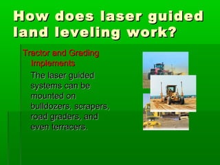
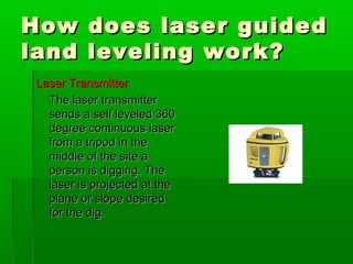
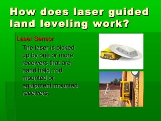
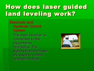
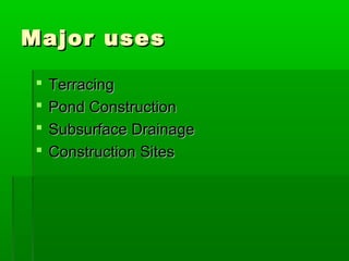
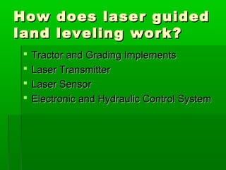
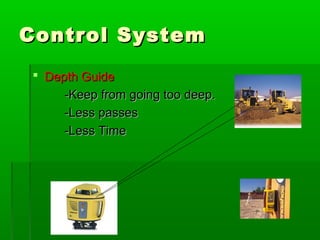
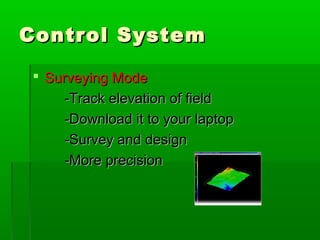
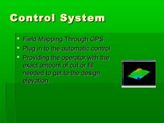
Laser Guided LandLaser Guided Land
LevelingLeveling
By: Asad RasheedBy: Asad Rasheed
Major usesMajor uses
 TerracingTerracing
 Pond ConstructionPond Construction
 Subsurface DrainageSubsurface Drainage
 Construction SitesConstruction Sites
How does laser guidedHow does laser guided
land leveling work?land leveling work?
 Tractor and Grading ImplementsTractor and Grading Implements
 Laser TransmitterLaser Transmitter
 Laser SensorLaser Sensor
 Electronic and Hydraulic Control SystemElectronic and Hydraulic Control System
How does laser guidedHow does laser guided
land leveling work?land leveling work?
Tractor and GradingTractor and Grading
ImplementsImplements
The laser guidedThe laser guided
systems can besystems can be
mounted onmounted on
bulldozers, scrapers,bulldozers, scrapers,
road graders, androad graders, and
even terracers.even terracers.
How does laser guidedHow does laser guided
land leveling work?land leveling work?
Laser TransmitterLaser Transmitter
The laser transmitterThe laser transmitter
sends a self leveled 360sends a self leveled 360
degree continuous laserdegree continuous laser
from a tripod in thefrom a tripod in the
middle of the site amiddle of the site a
person is digging. Theperson is digging. The
laser is projected at thelaser is projected at the
plane or slope desiredplane or slope desired
for the dig.for the dig.
How does laser guidedHow does laser guided
land leveling work?land leveling work?
Laser SensorLaser Sensor
The laser is pickedThe laser is picked
up by one or moreup by one or more
receivers that arereceivers that are
hand held, rodhand held, rod
mounted ormounted or
equipment mountedequipment mounted
receivers.receivers.
How does laser guidedHow does laser guided
land leveling work?land leveling work?
Electronic andElectronic and
Hydraulic ControlHydraulic Control
SystemSystem
The laser receiver isThe laser receiver is
connected to theconnected to the
equipmentsequipments
hydraulics. Thehydraulics. The
signals from the lasersignals from the laser
are used to controlare used to control
hydraulic valves.hydraulic valves.
Control SystemControl System
 Depth GuideDepth Guide
-Keep from going too deep.-Keep from going too deep.
-Less passes-Less passes
-Less Time-Less Time
Control SystemControl System
 Surveying ModeSurveying Mode
-Track elevation of field-Track elevation of field
-Download it to your laptop-Download it to your laptop
-Survey and design-Survey and design
-More precision-More precision
Control SystemControl System
 Field Mapping Through GPSField Mapping Through GPS
 Plug in to the automatic controlPlug in to the automatic control
 Providing the operator with theProviding the operator with the
exact amount of cut or fillexact amount of cut or fill
needed to get to the designneeded to get to the design
elevation.elevation.
AdvantagesAdvantages
 Time SavingTime Saving
80% reduction in dirt movement80% reduction in dirt movement
 Less LaborLess Labor
 Little Or No ErrorLittle Or No Error
 Cost EffectiveCost Effective
AdvantagesAdvantages
Less Time and Less LaborLess Time and Less Labor
Fewer passes = Less timeFewer passes = Less time
No surveying, Less man power andNo surveying, Less man power and
Better finished grade = Less laborBetter finished grade = Less labor
AdvantagesAdvantages
Little or no Error and Cost EffectiveLittle or no Error and Cost Effective
With the laser Guided technology theWith the laser Guided technology the
only error possible is human error.only error possible is human error.
Little error, less labor and less time =Little error, less labor and less time =
More cost effectiveMore cost effective
DisadvantagesDisadvantages
 CostCost
$9000 +$9000 +
 Human ErrorHuman Error

Laser guided land leveling

  • 1.
    Laser Guided LandLaserGuided Land LevelingLeveling By: Asad RasheedBy: Asad Rasheed
  • 2.
    Major usesMajor uses TerracingTerracing  Pond ConstructionPond Construction  Subsurface DrainageSubsurface Drainage  Construction SitesConstruction Sites
  • 3.
    How does laserguidedHow does laser guided land leveling work?land leveling work?  Tractor and Grading ImplementsTractor and Grading Implements  Laser TransmitterLaser Transmitter  Laser SensorLaser Sensor  Electronic and Hydraulic Control SystemElectronic and Hydraulic Control System
  • 4.
    How does laserguidedHow does laser guided land leveling work?land leveling work? Tractor and GradingTractor and Grading ImplementsImplements The laser guidedThe laser guided systems can besystems can be mounted onmounted on bulldozers, scrapers,bulldozers, scrapers, road graders, androad graders, and even terracers.even terracers.
  • 5.
    How does laserguidedHow does laser guided land leveling work?land leveling work? Laser TransmitterLaser Transmitter The laser transmitterThe laser transmitter sends a self leveled 360sends a self leveled 360 degree continuous laserdegree continuous laser from a tripod in thefrom a tripod in the middle of the site amiddle of the site a person is digging. Theperson is digging. The laser is projected at thelaser is projected at the plane or slope desiredplane or slope desired for the dig.for the dig.
  • 6.
    How does laserguidedHow does laser guided land leveling work?land leveling work? Laser SensorLaser Sensor The laser is pickedThe laser is picked up by one or moreup by one or more receivers that arereceivers that are hand held, rodhand held, rod mounted ormounted or equipment mountedequipment mounted receivers.receivers.
  • 7.
    How does laserguidedHow does laser guided land leveling work?land leveling work? Electronic andElectronic and Hydraulic ControlHydraulic Control SystemSystem The laser receiver isThe laser receiver is connected to theconnected to the equipmentsequipments hydraulics. Thehydraulics. The signals from the lasersignals from the laser are used to controlare used to control hydraulic valves.hydraulic valves.
  • 8.
    Control SystemControl System Depth GuideDepth Guide -Keep from going too deep.-Keep from going too deep. -Less passes-Less passes -Less Time-Less Time
  • 9.
    Control SystemControl System Surveying ModeSurveying Mode -Track elevation of field-Track elevation of field -Download it to your laptop-Download it to your laptop -Survey and design-Survey and design -More precision-More precision
  • 10.
    Control SystemControl System Field Mapping Through GPSField Mapping Through GPS  Plug in to the automatic controlPlug in to the automatic control  Providing the operator with theProviding the operator with the exact amount of cut or fillexact amount of cut or fill needed to get to the designneeded to get to the design elevation.elevation.
  • 11.
    AdvantagesAdvantages  Time SavingTimeSaving 80% reduction in dirt movement80% reduction in dirt movement  Less LaborLess Labor  Little Or No ErrorLittle Or No Error  Cost EffectiveCost Effective
  • 12.
    AdvantagesAdvantages Less Time andLess LaborLess Time and Less Labor Fewer passes = Less timeFewer passes = Less time No surveying, Less man power andNo surveying, Less man power and Better finished grade = Less laborBetter finished grade = Less labor
  • 13.
    AdvantagesAdvantages Little or noError and Cost EffectiveLittle or no Error and Cost Effective With the laser Guided technology theWith the laser Guided technology the only error possible is human error.only error possible is human error. Little error, less labor and less time =Little error, less labor and less time = More cost effectiveMore cost effective
  • 14.