Landslide Early Warning - Czech Republic 2009
•
1 like•872 views

Aunque soy co-autor de este trabajo, el mismo fue presentando por mi buen amigo de INETER: Alex Castellón.

Recommended
More Related Content
What's hot
What's hot (20)
Similar to Landslide Early Warning - Czech Republic 2009
Similar to Landslide Early Warning - Czech Republic 2009 (20)
More from Vladimir Gutierrez, PhD
More from Vladimir Gutierrez, PhD (20)
Recently uploaded
Recently uploaded (20)
Landslide Early Warning - Czech Republic 2009
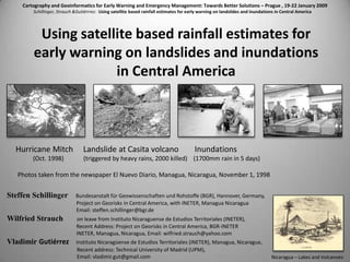
- 1. Cartography and Geoinformatics for Early Warning and Emergency Management: Towards Better Solutions – Prague , 19-22 January 2009 Schillinger, Strauch &Gutiérrrez: Using satellite based rainfall estimates for early warning on landslides and inundations in Central America Using satellite based rainfall estimates for early warning on landslides and inundations in Central America Steffen Schillinger Bundesanstalt für Geowissenschaften und Rohstoffe (BGR), Hannover, Germany, Project on Georisks in Central America, with INETER, Managua Nicaragua Email: steffen.schillinger@bgr.de Wilfried Strauch on leave from Instituto Nicaraguense de Estudios Territoriales (INETER), Recent Address: Project on Georisks in Central America, BGR-INETER INETER, Managua, Nicaragua, Email: wilfried.strauch@yahoo.com Vladimir Gutiérrez Instituto Nicaragüense de Estudios Territoriales (INETER), Managua, Nicaragua, Recent address: Technical University of Madrid (UPM), Email: vladimir.gut@gmail.com Hurricane Mitch Landslide at Casita volcano Inundations (Oct. 1998) (triggered by heavy rains, 2000 killed) (1700mm rain in 5 days) Photos taken from the newspaper El Nuevo Diario, Managua, Nicaragua, November 1, 1998 Nicaragua – Lakes and Volcanoes
- 2. Cartography and Geoinformatics for Early Warning and Emergency Management: Towards Better Solutions – Prague , 19-22 January 2009 Schillinger, Strauch &Gutiérrrez: Using satellite based rainfall estimates for early warning on landslides and inundations in Central America Landslide Hazard and Risk in Central America Landslide Hazard Risk death/year/km2 Population density From: Nadim, F., O. Kjekstad, P. Peduzzi, C. Herold, C. Jaedicke (2006), Global landslide and avalanche, hotspots, J. Landslides, 3(2), 159–173, doi:10.1007/ s10346-006-0036-1.
- 3. Cartography and Geoinformatics for Early Warning and Emergency Management: Towards Better Solutions – Prague , 19-22 January 2009 Schillinger, Strauch &Gutiérrrez: Using satellite based rainfall estimates for early warning on landslides and inundations in Central America From: Devoli , Morales & Høeg (2006) Historical landslides in Nicaragua—collection and analysis of data, Landslides, DOI 10.1007/s10346-006-0048-x Trigger phenomena Type of landslide Occurrence over the year Damage caused Characterization of 135 historical landslides in Nicaragua, 1800-1990 main hurricane and raining season
- 4. Cartography and Geoinformatics for Early Warning and Emergency Management: Towards Better Solutions – Prague , 19-22 January 2009 Schillinger, Strauch &Gutiérrrez: Using satellite based rainfall estimates for early warning on landslides and inundations in Central America Strong and/or long lasting rains trigger landslides Extreme example: Hurricane Mitch, Nicaragua, October 30, 1998 “Normal” example: Landslides due to tropical storms during rainy season 2 km 15 km 2 villages annihilated More than 2000 people died Honduras, Sept.2008
- 5. Cartography and Geoinformatics for Early Warning and Emergency Management: Towards Better Solutions – Prague , 19-22 January 2009 Schillinger, Strauch &Gutiérrrez: Using satellite based rainfall estimates for early warning on landslides and inundations in Central America From: Devoli , Strauch , Chávez , Høeg (2007) A landslide database for Nicaragua: a tool for landslide-hazard management, Landslides DOI 10.1007/s10346-006-0074-8 Recent Landslides Inventory of Nicaragua About 17,000 events Most of these events occurred during hurricane Mitch in 1998 !
- 6. Cartography and Geoinformatics for Early Warning and Emergency Management: Towards Better Solutions – Prague , 19-22 January 2009 Schillinger, Strauch &Gutiérrrez: Using satellite based rainfall estimates for early warning on landslides and inundations in Central America Met station - Precipitation data Monitoring software - Verification Field visits or reports from local population In some cases - real time verification possible with seismic stations near the gullies Mapping of impact If precipitation > trigger level -> Alert Solution works but… Problem: In case of local rains - data of met station are representative only for a small area. e.g. for one side of a volcano. Too many stations would be necessary for an operative system First Trial: Pilot project INETER-NGI, 2000-2004 Early Warning with meteorological stations, in volcanoes
- 7. Cartography and Geoinformatics for Early Warning and Emergency Management: Towards Better Solutions – Prague , 19-22 January 2009 Schillinger, Strauch &Gutiérrrez: Using satellite based rainfall estimates for early warning on landslides and inundations in Central America PRO: -Near real time data CON: -Station density is far too low to permit reliable detection of high precipitation in areas under landslide risk There are no met radars in Nicaragua or Central America Landslide map Nicaraguan Meteorological Network
- 8. Cartography and Geoinformatics for Early Warning and Emergency Management: Towards Better Solutions – Prague , 19-22 January 2009 Schillinger, Strauch &Gutiérrrez: Using satellite based rainfall estimates for early warning on landslides and inundations in Central America Solution : Hydroestimator - Precipitation estimate from GOES Met satellite • NOAA/NESDIS calculates twice per hour precipitation estimates • Precipitation is determined in near real time for 4x4 km pixels • These data are available from: ftp://www.orbit.nesdis.noaa.gov/pub/smcd/emb/f_f/hydroest/grads/centralamerica • Several authors have investigated the usefulness of the method for landslide early warning
- 9. Cartography and Geoinformatics for Early Warning and Emergency Management: Towards Better Solutions – Prague , 19-22 January 2009 Schillinger, Strauch &Gutiérrrez: Using satellite based rainfall estimates for early warning on landslides and inundations in Central America The precipitation rates were obtained from a fit between instantaneous radar derived rainfall estimates and satellite measurements of IR brightness temperatures at cloud top. The relationship has been computed using 4-Km resolution pairs of GOES-8 IR images and collocated instantaneous radar rainfall estimates from the US operational network of 5 and 10 cm radar (WSR-57S, WSR-74C, WSR-88D) in the central Great Plains and the areas adjacent to the Gulf of Mexico. Background of Hydroestimator: Relation between upper cloud temperature from GOES IR images and precipitation rate The result of the comparison between the mean radar-derived estimates for each one degree temperature intervals from 195 K to 260 K is shown in the figure. From: Vicente, G.A. Scofield R. A. and Menzel, W.P. (1998) The Operational GOES Infrared Rainfall Estimation Technique, edition of the Bulletin of American Meteorological Society, September 1998
- 10. Cartography and Geoinformatics for Early Warning and Emergency Management: Towards Better Solutions – Prague , 19-22 January 2009 Schillinger, Strauch &Gutiérrrez: Using satellite based rainfall estimates for early warning on landslides and inundations in Central America “The satellite estimates showed that the heaviest rainfall occurred October 31 when outer convective bands from Mitch interacted and merged with the orographic produced convection that was already present in northwest Nicaragua. Accumulation of 3-day totals indicates that the heaviest rains occurred over Nicaragua with precipitation amounts maximum of 1400 mm (55 inches).” From: Ferraro, R., G. A. Vicente, M. Ba, A. Gruber, R. Scofield, Q. Li and R. Weldon (1999) Satellite Techniques Yield Insight into Devastating Rainfall from Hurricane Mitch. EOS, Transaction, AGU, Vol. 80, No. 43, 10/26/1999, 512-514. Application of Hydroestimator to Hurricane Mitch data Location of Casita Volcano – Disaster on October 30, 1998 2000+ killed Comparison with precipitation recorded by INETER met stations: Chinandega 1,613 mm León 1 ,113mm Masatepe 663mm Managua 545mm Rivas 495mm
- 11. Cartography and Geoinformatics for Early Warning and Emergency Management: Towards Better Solutions – Prague , 19-22 January 2009 Schillinger, Strauch &Gutiérrrez: Using satellite based rainfall estimates for early warning on landslides and inundations in Central America Global rainfall intensity-duration curve for triggering landslides From: Hong Y., Adler R.E., Huffmann G.J. (2007). Satellite Remote Sensing, for Global Landslide Monitoring, Eos, Vol. 88, No. 37, 11 September 2007
- 12. Cartography and Geoinformatics for Early Warning and Emergency Management: Towards Better Solutions – Prague , 19-22 January 2009 Schillinger, Strauch &Gutiérrrez: Using satellite based rainfall estimates for early warning on landslides and inundations in Central America Application : Generation of interactive precipitation maps (author: St. Schillinger) Nesessary software: ArcGIS 9.3 y VS2008, ArcSDE, Arc server Functions: •Download hourly precipitation data from NESDIS/NOAA (in GrADS format); •Archive original data •Convert data to ESRI raster format; •Archive data in a raster catalogue of an ArcSDE geodatabase; •Calculate sums of 3, 6, 24 hours, 2, 3, 7 days •Archive results in standardized GeoTiff, PNG formats; •Get the online data from INETER´s Met Network •Create an interactive map for ArcGis Server with the precipitation rasters including met station data •Publish interactive map with ArcGis Server Development of applications for the use of Hydroestimator
- 13. Cartography and Geoinformatics for Early Warning and Emergency Management: Towards Better Solutions – Prague , 19-22 January 2009 Schillinger, Strauch &Gutiérrrez: Using satellite based rainfall estimates for early warning on landslides and inundations in Central America Client Application – Selection of the rain accumulation period www.georiesgos-ca.info
- 14. Cartography and Geoinformatics for Early Warning and Emergency Management: Towards Better Solutions – Prague , 19-22 January 2009 Schillinger, Strauch &Gutiérrrez: Using satellite based rainfall estimates for early warning on landslides and inundations in Central America Client Application– Access to the data base of INETER´s met stations www.georiesgos-ca.info
- 15. Cartography and Geoinformatics for Early Warning and Emergency Management: Towards Better Solutions – Prague , 19-22 January 2009 Schillinger, Strauch &Gutiérrrez: Using satellite based rainfall estimates for early warning on landslides and inundations in Central America Client Application–automatic classification of precipitation www.georiesgos-ca.info
- 16. Cartography and Geoinformatics for Early Warning and Emergency Management: Towards Better Solutions – Prague , 19-22 January 2009 Schillinger, Strauch &Gutiérrrez: Using satellite based rainfall estimates for early warning on landslides and inundations in Central America Client Application– Obtain precipitation estimate for a certain site www.georiesgos-ca.info
- 17. Cartography and Geoinformatics for Early Warning and Emergency Management: Towards Better Solutions – Prague , 19-22 January 2009 Schillinger, Strauch &Gutiérrrez: Using satellite based rainfall estimates for early warning on landslides and inundations in Central America Application: Early warning for landslide sites (author: W.Strauch) Nesessary software: GrADS and other free software components Functions: •Download hourly precipitation data from NESDIS/NOAA (in GrADS format); •Archive original data •Determine precipitations for a list of landslide sites for testing: (1) sites of known landslides in Nicaragua (2) sites of the Central American Volcanoes •If accumulated precipitation surpasses a trigger level – -> generate an email message •Send the email to a list of recipients •Generate precipitation maps in GIF format (local, national, regional) •Generate GIF animation of precipitation in the last 24 hours •Transfer GIF maps and animation to Web server for publication Development of applications for the use of Hydroestimator
- 18. Cartography and Geoinformatics for Early Warning and Emergency Management: Towards Better Solutions – Prague , 19-22 January 2009 Schillinger, Strauch &Gutiérrrez: Using satellite based rainfall estimates for early warning on landslides and inundations in Central America Regional GIF animation using original NESDIS files Local map with numeric precipitation values Precipitation map for Nicaragua
- 19. Cartography and Geoinformatics for Early Warning and Emergency Management: Towards Better Solutions – Prague , 19-22 January 2009 Schillinger, Strauch &Gutiérrrez: Using satellite based rainfall estimates for early warning on landslides and inundations in Central America Monitored landslide sites in Nicaragua Example of alert message: Alerta para Coordenadas: -87.0064 12.7017 Sitio: Mocorón, Municipio : Chinandega 2008/09/29 04:00 Precipitación de 38.4 mm en 1 hora(s) sobrepasa el umbral de 10.5 mm Aumenta la posibilidad de deslizamientos en la zona! Example of output list of early warning application: Long_W Lat_N Ubicación Municipio 0 mm at -86.3092 11.9923 Carretera,_entrada_a_El_Crucero EL_CRUCERO 0 mm at -86.3111 11.9634 Carretera_El_Crucero-San_Rafael EL_CRUCERO 0 mm at -86.4757 11.9439 Comunidad_Las_Cañas VILLA_EL_CARMEN 2 mm at -86.3514 12.2366 Peninsula_de_Chiltepe MATEARE 2 mm at -86.3316 12.2492 Peninsula_de_Chiltepe_MATEARE 0 mm at -86.9148 12.6795 El_Higueral CHINANDEGA 9 mm at -86.9148 12.6795 San_Lucas CHINANDEGA 38.4 mm at -87.0064 12.7017 Mocorón CHINANDEGA 7 mm at -87.0064 12.7017 Las_Rojas CHINANDEGA 6 mm at -87.0064 12.7017 Las_Banderas CHINANDEGA 5 mm at -87.0064 12.7017 La_Laguna CHINANDEGA 0 mm at -87.0064 12.7017 San_Rafael CHINANDEGA ... ...
- 20. Cartography and Geoinformatics for Early Warning and Emergency Management: Towards Better Solutions – Prague , 19-22 January 2009 Schillinger, Strauch &Gutiérrrez: Using satellite based rainfall estimates for early warning on landslides and inundations in Central America Central American active volcanoes monitored At the moment the list contains one site per volcano. In future it will be extended to contain the different gullies of each volcano where landslides (lahars) are frequent.
- 21. Cartography and Geoinformatics for Early Warning and Emergency Management: Towards Better Solutions – Prague , 19-22 January 2009 Schillinger, Strauch &Gutiérrrez: Using satellite based rainfall estimates for early warning on landslides and inundations in Central America Application of method during Hurricane Felix, September 2007 The hurricane was monitored with the system while crossing Nicaragua. It was observed that the precipitations in the mountainous areas did not surpass the levels to trigger landslides. Thus, it was not necessary to declare high alert levels.
- 22. Cartography and Geoinformatics for Early Warning and Emergency Management: Towards Better Solutions – Prague , 19-22 January 2009 Schillinger, Strauch &Gutiérrrez: Using satellite based rainfall estimates for early warning on landslides and inundations in Central America Application for Assessment of Flash flood in Matagalpa, October 17, 2007
- 23. Cartography and Geoinformatics for Early Warning and Emergency Management: Towards Better Solutions – Prague , 19-22 January 2009 Schillinger, Strauch &Gutiérrrez: Using satellite based rainfall estimates for early warning on landslides and inundations in Central America Flash flood in the city of Matagalpa 17 october, 2007, 18:00 local time 7 killed Inundation map Sequence of precipitation images showing the strong rain which caused the flooding
- 24. Cartography and Geoinformatics for Early Warning and Emergency Management: Towards Better Solutions – Prague , 19-22 January 2009 Schillinger, Strauch &Gutiérrrez: Using satellite based rainfall estimates for early warning on landslides and inundations in Central America Results: 1. Satellite based precipitation monitoring for Central America in place; 2. Webmapping service for precipitation maps in place; 3. Experimental early warning system for selected sites in place; 4. Asessment of landslide and inundation occurrence carried out for some events. Future plans: 1. Compilation of lists of landslide sites for each Central American country and integration in the early warning procedure; 2. Investigation of landslide occurrence and corresponding precipitations; 3. Determination of local rainfall intensity-duration curves for triggering landslides for different site classes (geology) in Central America; 4. Information and training to emergency commissions and local authorities about the use of warning messages; 5. Development of early warning system on inundations. Results and future plans
- 25. Cartography and Geoinformatics for Early Warning and Emergency Management: Towards Better Solutions – Prague , 19-22 January 2009 Schillinger, Strauch &Gutiérrrez: Using satellite based rainfall estimates for early warning on landslides and inundations in Central America Thank You ! This work is developed in the frame of the projects “Mitigation of Georisks in Central America” with funding from the governments of Germany and Central American countries and “Early Warning of Landslides in Nicaragua “with funding from the Norwegian government. The specific tasks for this paper were carried out in cooperation beween BGR (Hannover,Germany) , INETER (Managua, Nicaragua), with support from NGI(Oslo, Norway). www.georiesgos-ca.info www.georiesgos-ca.info