2. PHASE 2 Methodology
The MOST/ComMIT NOAA code and GUI interface
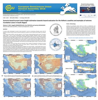
is used to simulate tsunami propagation and
estimate inundation zones, for the four largest
cities in the South Aegean region (Chania,
Rethimnon, Heraklion, Kalamata).
The largest known, reported and studied
earthquake event in the Eastern Mediterranean
was selected (365AD west of Crete with
considered magnitude Mw=8.5), as a key example
for our study.
High resolution DEMS were joined with 5m
resolution in topography and 30m in bathymetry,
respectively.
The results were further processed via a GIS tool
interface and inundation maps were produced for
the four selected cities.
For the Heraklion city inundation maps focused on
areas with public and tourist interest were
produced. They were used in a workshop-exercise
with local civil protection agencies, under the
leading coordination of the Department of Civil
Protection of the Decentralized Administration of
Crete.
For further information and queries please contact: nmelis@noa.gr
This work has been completed
under the project KRIPIS – ASPIDA
In Phase 2 of our study, we considered the 365AD earthquake event that devastated the East Mediterranean Basin (Shaw et al., 2008) as the example to apply the
methodology (seismic/tsunami source, tsunami propagation, coastal impact). This most extensively studied event regarding modelling, synthetics and field data justification
investigations was selected. We prepared using MOST (Initial Conditions (left) and Maximum Wave Height Propagation for the selected source (right)). The latter is the input
for the MOST/ComMIT platform with the GUI interface as a user friendly tool.
REFERENCES
Annunziato, A. (2007). The Tsunami Assessment Modelling System by the Joint Research Centre. Science of Tsunami Hazards, 26:2, 70–92.
Gica, E., Spillane, M., Titov, V.V., Chamberlin, C.D., and Newman, J.C. (2008), Development of the forecast propagation database for NOAA’s Short-term Inundation Forecast for
Tsunamis (SIFT), NOAA Tech. Memo. OAR PMEL-139, NTIS: PB2008-109391, 89 pp.
Mitsoudis, D. A., E. T. Flouri, N. Chrysoulakis, Y. Kamarianakis, E. A. Okal, C. E. Synolakis, (2012). Tsunami hazard in the southeast Aegean Sea, Coastal Engineering, 60, 136–148.
Necmioglu, O. and Ozel, N. M. (2015). Earthquake Scenario-Based Tsunami Wave Heights in the Eastern Mediterranean and Connected Seas, Pure Appl. Geophys., DOI
10.1007/s00024-015-1069-y.
Okada, Y. (1985) Surface deformation due to shear and tensile faults in a half-space, Bull. Seism. Soc. Am., 75, 1435-1154.
Papaioannou, Ch. A. and B. C. Papazachos, (2000). Time-Independent and Time-Dependent Seismic Hazard in Greece Based on Seismogenic Sources, Bulletin of the
Seismological Society of America, 90, 1, 22–33.
Shaw, B., Ambraseys, N. N., England, P. C., Floyd, M. A., Gorman, G. J, Higham, T. F. G., Jackson, J. A., Nocquet, J.-M., Pain, C. C., and Piggot, M. D. (2008). Eastern Mediterranean
tectonics and tsunami hazard inferred from the AD 365 earthquake; Nature Geoscience Vol. 1 April 2008.
Synolakis, C.E., E.N. Bernard, V.V. Titov, U. Kânoğlu, and F.I. González (2007): Standards, criteria, and procedures for NOAA evaluation of tsunami numerical models. NOAA Tech.
Memo. OAR PMEL-135, NOAA/Pacific Marine Environmental Laboratory, SeaUle, WA, 55 pp.
Titov, V.V. and Gonzalez, F.I. (1997). Implementation and testing of the method of splitting tsunami (MOST), NOAA Technical Memorandum ERL-PMEL-112, PB98-122773, Pacific
Marine Environmental Laboratory, Seattle, Washington, 11 pp.
Titov, V.V. and Synolakis, C.E. (1998). Numerical modeling of tidal wave runup, J. Waterw. Port Ocean Coast. Eng. 124(4), 157–171.
Titov, V., Moore, C., Greenslade, D., Pattiaratchi, C., Badal, R., Synolakis, C., and Kanoglu, U. (2011). A New Tool for Inundation Modeling: Community Modeling Interface for
Tsunamis (ComMIT), Pure Appl. Geophys., doi:10.1007/s00024-011-0292-4.
Vamvakaris, D.A., C. B., Papazachos, C., Papaioannou, E. M. Scordilis, and G. F. Karakaisis, (2016). A detailed seismic zonation model for shallow earthquakes in the broader
Aegean area, Nat. Hazards Earth Syst. Sci., 16, 55-84, www.nat-hazards-earth-syst-sci.net/16/55/2016/, doi:10.5194/nhess-16-55-2016.
Defined Inundation Zones
at Heraklion:
west end of the city (right),
hotel / beach coastal zone
west of the city (below)
Rethimnon Kalamata
Zoom at the city of Kalamata
Heraklion
Chania
location map of selected sites and the 365AD epicenter
[ the case as it has been processed with ComMIT GUI interface in Windows (some representative screen dumps) ]
[ for these cases, the results with ComMIT (inundation zones)
are presented after some basic GIS reprocessing ]
![PHASE 2 Methodology
The MOST/ComMIT NOAA code and GUI interface
is used to simulate tsunami propagation and
estimate inundation zones, for the four largest
cities in the South Aegean region (Chania,
Rethimnon, Heraklion, Kalamata).
The largest known, reported and studied
earthquake event in the Eastern Mediterranean
was selected (365AD west of Crete with
considered magnitude Mw=8.5), as a key example
for our study.
High resolution DEMS were joined with 5m
resolution in topography and 30m in bathymetry,
respectively.
The results were further processed via a GIS tool
interface and inundation maps were produced for
the four selected cities.
For the Heraklion city inundation maps focused on
areas with public and tourist interest were
produced. They were used in a workshop-exercise
with local civil protection agencies, under the
leading coordination of the Department of Civil
Protection of the Decentralized Administration of
Crete.
For further information and queries please contact: nmelis@noa.gr
This work has been completed
under the project KRIPIS – ASPIDA
In Phase 2 of our study, we considered the 365AD earthquake event that devastated the East Mediterranean Basin (Shaw et al., 2008) as the example to apply the
methodology (seismic/tsunami source, tsunami propagation, coastal impact). This most extensively studied event regarding modelling, synthetics and field data justification
investigations was selected. We prepared using MOST (Initial Conditions (left) and Maximum Wave Height Propagation for the selected source (right)). The latter is the input
for the MOST/ComMIT platform with the GUI interface as a user friendly tool.
REFERENCES
Annunziato, A. (2007). The Tsunami Assessment Modelling System by the Joint Research Centre. Science of Tsunami Hazards, 26:2, 70–92.
Gica, E., Spillane, M., Titov, V.V., Chamberlin, C.D., and Newman, J.C. (2008), Development of the forecast propagation database for NOAA’s Short-term Inundation Forecast for
Tsunamis (SIFT), NOAA Tech. Memo. OAR PMEL-139, NTIS: PB2008-109391, 89 pp.
Mitsoudis, D. A., E. T. Flouri, N. Chrysoulakis, Y. Kamarianakis, E. A. Okal, C. E. Synolakis, (2012). Tsunami hazard in the southeast Aegean Sea, Coastal Engineering, 60, 136–148.
Necmioglu, O. and Ozel, N. M. (2015). Earthquake Scenario-Based Tsunami Wave Heights in the Eastern Mediterranean and Connected Seas, Pure Appl. Geophys., DOI
10.1007/s00024-015-1069-y.
Okada, Y. (1985) Surface deformation due to shear and tensile faults in a half-space, Bull. Seism. Soc. Am., 75, 1435-1154.
Papaioannou, Ch. A. and B. C. Papazachos, (2000). Time-Independent and Time-Dependent Seismic Hazard in Greece Based on Seismogenic Sources, Bulletin of the
Seismological Society of America, 90, 1, 22–33.
Shaw, B., Ambraseys, N. N., England, P. C., Floyd, M. A., Gorman, G. J, Higham, T. F. G., Jackson, J. A., Nocquet, J.-M., Pain, C. C., and Piggot, M. D. (2008). Eastern Mediterranean
tectonics and tsunami hazard inferred from the AD 365 earthquake; Nature Geoscience Vol. 1 April 2008.
Synolakis, C.E., E.N. Bernard, V.V. Titov, U. Kânoğlu, and F.I. González (2007): Standards, criteria, and procedures for NOAA evaluation of tsunami numerical models. NOAA Tech.
Memo. OAR PMEL-135, NOAA/Pacific Marine Environmental Laboratory, SeaUle, WA, 55 pp.
Titov, V.V. and Gonzalez, F.I. (1997). Implementation and testing of the method of splitting tsunami (MOST), NOAA Technical Memorandum ERL-PMEL-112, PB98-122773, Pacific
Marine Environmental Laboratory, Seattle, Washington, 11 pp.
Titov, V.V. and Synolakis, C.E. (1998). Numerical modeling of tidal wave runup, J. Waterw. Port Ocean Coast. Eng. 124(4), 157–171.
Titov, V., Moore, C., Greenslade, D., Pattiaratchi, C., Badal, R., Synolakis, C., and Kanoglu, U. (2011). A New Tool for Inundation Modeling: Community Modeling Interface for
Tsunamis (ComMIT), Pure Appl. Geophys., doi:10.1007/s00024-011-0292-4.
Vamvakaris, D.A., C. B., Papazachos, C., Papaioannou, E. M. Scordilis, and G. F. Karakaisis, (2016). A detailed seismic zonation model for shallow earthquakes in the broader
Aegean area, Nat. Hazards Earth Syst. Sci., 16, 55-84, www.nat-hazards-earth-syst-sci.net/16/55/2016/, doi:10.5194/nhess-16-55-2016.
Defined Inundation Zones
at Heraklion:
west end of the city (right),
hotel / beach coastal zone
west of the city (below)
Rethimnon Kalamata
Zoom at the city of Kalamata
Heraklion
Chania
location map of selected sites and the 365AD epicenter
[ the case as it has been processed with ComMIT GUI interface in Windows (some representative screen dumps) ]
[ for these cases, the results with ComMIT (inundation zones)
are presented after some basic GIS reprocessing ]](data:image/gif;base64,R0lGODlhAQABAIAAAAAAAP///yH5BAEAAAAALAAAAAABAAEAAAIBRAA7)