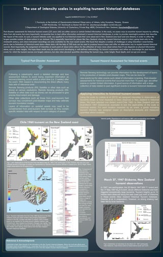
Following a catastrophic event, a detailed damage and loss assessment is conducted within 2 weeks to document effects before recovery occurs. Remote sensing data like satellite imagery can process flood extent and damage at various resolutions. Post-disaster field surveys complement remote sensing data and disaster maps, providing asset-level details. For historical events over 15 years ago, assessments are scarce with limited information, but tsunami databases provide a good source of data on past significant events. This study assesses utilizing data from old tsunami events by examining intensity scales applied to two historical New Zealand events to exploit database information for hazard assessments.


![tsunami[1].ppt](https://cdn.slidesharecdn.com/ss_thumbnails/tsunami1-231127130957-c1e5872b-thumbnail.jpg?width=640&height=640&fit=bounds)


