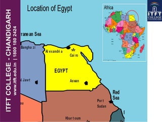
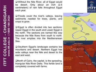
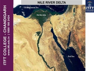
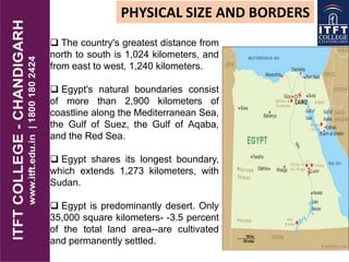
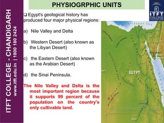
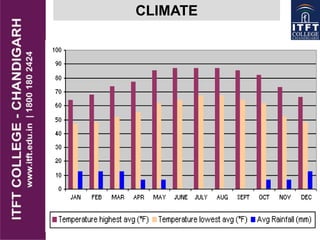
EGYPT
 Official Name: Arab
Republic of Egypt
Form of Government:
Republic
Capital: Cairo
Population: 80
million(appox)
Official Language:
Arabic
Money: Egyptian
pound, Guiney
Area: 3,86,662 sq mi
(1,001,449 sq km)
Major Mountain
Ranges: Eastern Highlands
Major River: Nile
 Without the Nile River, all of Egypt would
be desert. Only about an inch (2.5
centimeters) of rain falls throughout Egypt
each year.
 Floods cover the river's valleys, leaving
sediments needed for trees, plants, and
crops to grow.
 Egypt is often divided into two sections:
Upper Egypt in the south and Lower Egypt in
the north. The sections are named this way
because the Nile flows from south to north.
The river empties into the Mediterranean
Sea.
 Southern Egypt's landscape contains low
mountains and desert. Northern Egypt has
wide valleys near the Nile and desert to the
east and west.
North of Cairo, the capital, is the sprawling,
triangular Nile River Delta. This fertile land is
completely covered with farms.
NILE RIVER DELTA
 About 90 percent of
Egyptians are Muslim, which
means they are followers of the
Islam religion. Islam dominates
Egyptian society.
 About 10 percent of
Egyptians are Copts, one of the
oldest branches of the Christian
religion.
 Egypt's population is
growing rapidly. This puts
strains on Egypt's resources,
since most people live in a
narrow strip of land along the
Nile River
PEOPLE AND CULTURE
PHYSICAL SIZE AND BORDERS
 The country's greatest distance from
north to south is 1,024 kilometers, and
from east to west, 1,240 kilometers.
 Egypt's natural boundaries consist
of more than 2,900 kilometers of
coastline along the Mediterranean Sea,
the Gulf of Suez, the Gulf of Aqaba,
and the Red Sea.
 Egypt shares its longest boundary,
which extends 1,273 kilometers, with
Sudan.
 Egypt is predominantly desert. Only
35,000 square kilometers- -3.5 percent
of the total land area--are cultivated
and permanently settled.
 Egypt's geological history has
produced four major physical regions:
a) Nile Valley and Delta
b) Western Desert (also known as
the Libyan Desert)
c) the Eastern Desert (also known
as the Arabian Desert)
d) the Sinai Peninsula.
The Nile Valley and Delta is the
most important region because
it supports 99 percent of the
population on the country's
only cultivable land.
PHYSIOGRPHIC UNITS
NILE VALLEY DELTA
 The Nile Valley and Delta, the most
extensive oasis on earth (a fertile spot
in the desert where water is found)
was created by the world's second-
longest river ,i.e River Nile
 Without the topographic channel that
permits the Nile to flow across the
Sahara, Egypt would be entirely desert;
the Nile River traverses about 1,600
kilometers through Egypt and flows
northward from the Egyptian-Sudanese
border to the Mediterranean Sea.
 At Cairo the Nile spreads out over
what was once a broad estuary that has
been filled by silt deposits to form a
fertile, fan-shaped delta about 250
kilometers wide at the seaward base.
 The Nile Delta extends over
approximately 22,000 square kilometers.
WESTERN DESERT
The Western Desert covers about
700,000 square kilometers and accounts
for about two-thirds of Egypt's land area.
 This immense desert to the west of
the Nile spans the area from the
Mediterranean Sea south to the
Sudanese border.
 Limited agricultural production, the
presence of some natural resources, and
permanent settlements are found all of
which have fresh water provided by the
Nile or by local groundwater.
 The Siwah Oasis,(A fertile spot in a
desert where water is found) is close to
the Libyan border is isolated from the
rest of Egypt but has sustained life since
ancient times.
The Siwah Oasis, close to the
Libyan border is isolated from the
rest of Egypt but has sustained life
since ancient times.
 The other major oases form a
topographic chain of basins
extending from the Al Fayyum
Oasis which lies sixty kilometers
southwest of Cairo, south to the
Bahriyah, Farafirah, and Dakhilah
oases before reaching the
country's largest oasis, Kharijah.
 Fayyum Oasis have permitted
extensive cultivation in an irrigated
area that extends over 1,800
square kilometers.
EASTERN DESERT
The topographic features of the region
east of the Nile are very different from
those of the Western Desert.
 The relatively mountainous Eastern
Desert rises abruptly from the Nile and
extends over an area of approximately
220,000 square kilometers
 This elevated region has a natural
drainage pattern that rarely functions
because of insufficient rainfall.
 The Eastern Desert is generally
isolated from the rest of the country.
There is no oasis cultivation in the region
because of the difficulty in sustaining
any form of agriculture.
Except for a few villages on the Red
Sea coast, there are no permanent
settlements.
SINAI PENINSULA
This triangular area covers about
61,100 square kilometers .
 Similar to the desert, the peninsula
contains mountains in its southern
sector that are a geological extension of
the Red Sea Hills, the low range along
the Red Sea coast that includes Mount
Catherine the country's highest point--
2,642 meters. The Red Sea is named
after these mountains, which are red.
 The southern side of the peninsula
has a sharp escarpment that subsides
after a narrow coastal shelf that slopes
into the Red Sea and the Gulf of Aqaba.
 The elevation of Sinai's southern rim
is about 1,000 meters.
CLIMATE
Egypt has a hot arid desert climate .It is hot or
warm during the day, and cool at night.
 In desert regions the temperature varies
greatly, especially in summer; it may range
from 7 C at night, to 40 C during the day.
 Sometime between March and May, a hot and
dry sand storm, known as Khamsin winds, blow
from the south east up to the north.
 Egypt receives less than 80 mm (3.15 in) of
precipitation annually in most areas, although in
the coastal areas it reaches 200 mm. It hardly
ever rains during the summer.

ITFT- egypt physical

  • 1.
  • 2.
     Official Name:Arab Republic of Egypt Form of Government: Republic Capital: Cairo Population: 80 million(appox) Official Language: Arabic Money: Egyptian pound, Guiney Area: 3,86,662 sq mi (1,001,449 sq km) Major Mountain Ranges: Eastern Highlands Major River: Nile
  • 4.
     Without theNile River, all of Egypt would be desert. Only about an inch (2.5 centimeters) of rain falls throughout Egypt each year.  Floods cover the river's valleys, leaving sediments needed for trees, plants, and crops to grow.  Egypt is often divided into two sections: Upper Egypt in the south and Lower Egypt in the north. The sections are named this way because the Nile flows from south to north. The river empties into the Mediterranean Sea.  Southern Egypt's landscape contains low mountains and desert. Northern Egypt has wide valleys near the Nile and desert to the east and west. North of Cairo, the capital, is the sprawling, triangular Nile River Delta. This fertile land is completely covered with farms.
  • 5.
  • 6.
     About 90percent of Egyptians are Muslim, which means they are followers of the Islam religion. Islam dominates Egyptian society.  About 10 percent of Egyptians are Copts, one of the oldest branches of the Christian religion.  Egypt's population is growing rapidly. This puts strains on Egypt's resources, since most people live in a narrow strip of land along the Nile River PEOPLE AND CULTURE
  • 7.
    PHYSICAL SIZE ANDBORDERS  The country's greatest distance from north to south is 1,024 kilometers, and from east to west, 1,240 kilometers.  Egypt's natural boundaries consist of more than 2,900 kilometers of coastline along the Mediterranean Sea, the Gulf of Suez, the Gulf of Aqaba, and the Red Sea.  Egypt shares its longest boundary, which extends 1,273 kilometers, with Sudan.  Egypt is predominantly desert. Only 35,000 square kilometers- -3.5 percent of the total land area--are cultivated and permanently settled.
  • 8.
     Egypt's geologicalhistory has produced four major physical regions: a) Nile Valley and Delta b) Western Desert (also known as the Libyan Desert) c) the Eastern Desert (also known as the Arabian Desert) d) the Sinai Peninsula. The Nile Valley and Delta is the most important region because it supports 99 percent of the population on the country's only cultivable land. PHYSIOGRPHIC UNITS
  • 9.
    NILE VALLEY DELTA The Nile Valley and Delta, the most extensive oasis on earth (a fertile spot in the desert where water is found) was created by the world's second- longest river ,i.e River Nile  Without the topographic channel that permits the Nile to flow across the Sahara, Egypt would be entirely desert; the Nile River traverses about 1,600 kilometers through Egypt and flows northward from the Egyptian-Sudanese border to the Mediterranean Sea.  At Cairo the Nile spreads out over what was once a broad estuary that has been filled by silt deposits to form a fertile, fan-shaped delta about 250 kilometers wide at the seaward base.  The Nile Delta extends over approximately 22,000 square kilometers.
  • 10.
    WESTERN DESERT The WesternDesert covers about 700,000 square kilometers and accounts for about two-thirds of Egypt's land area.  This immense desert to the west of the Nile spans the area from the Mediterranean Sea south to the Sudanese border.  Limited agricultural production, the presence of some natural resources, and permanent settlements are found all of which have fresh water provided by the Nile or by local groundwater.  The Siwah Oasis,(A fertile spot in a desert where water is found) is close to the Libyan border is isolated from the rest of Egypt but has sustained life since ancient times.
  • 11.
    The Siwah Oasis,close to the Libyan border is isolated from the rest of Egypt but has sustained life since ancient times.  The other major oases form a topographic chain of basins extending from the Al Fayyum Oasis which lies sixty kilometers southwest of Cairo, south to the Bahriyah, Farafirah, and Dakhilah oases before reaching the country's largest oasis, Kharijah.  Fayyum Oasis have permitted extensive cultivation in an irrigated area that extends over 1,800 square kilometers.
  • 12.
    EASTERN DESERT The topographicfeatures of the region east of the Nile are very different from those of the Western Desert.  The relatively mountainous Eastern Desert rises abruptly from the Nile and extends over an area of approximately 220,000 square kilometers  This elevated region has a natural drainage pattern that rarely functions because of insufficient rainfall.  The Eastern Desert is generally isolated from the rest of the country. There is no oasis cultivation in the region because of the difficulty in sustaining any form of agriculture. Except for a few villages on the Red Sea coast, there are no permanent settlements.
  • 13.
    SINAI PENINSULA This triangulararea covers about 61,100 square kilometers .  Similar to the desert, the peninsula contains mountains in its southern sector that are a geological extension of the Red Sea Hills, the low range along the Red Sea coast that includes Mount Catherine the country's highest point-- 2,642 meters. The Red Sea is named after these mountains, which are red.  The southern side of the peninsula has a sharp escarpment that subsides after a narrow coastal shelf that slopes into the Red Sea and the Gulf of Aqaba.  The elevation of Sinai's southern rim is about 1,000 meters.
  • 15.
  • 16.
    Egypt has ahot arid desert climate .It is hot or warm during the day, and cool at night.  In desert regions the temperature varies greatly, especially in summer; it may range from 7 C at night, to 40 C during the day.  Sometime between March and May, a hot and dry sand storm, known as Khamsin winds, blow from the south east up to the north.  Egypt receives less than 80 mm (3.15 in) of precipitation annually in most areas, although in the coastal areas it reaches 200 mm. It hardly ever rains during the summer.