Download to read offline
![International Research Journal of Engineering and Technology (IRJET) e-ISSN: 2395-0056
Volume: 06 Issue: 09 | Sep 2019 www.irjet.net p-ISSN: 2395-0072
© 2019, IRJET | Impact Factor value: 7.211 | ISO 9001:2008 Certified Journal | Page 1140
Vehicle Monitoring System using Internet of Things
Binod Chandra Shrestha1, Prakash Parajuli2, Sachin Kafle3, Prakash Bist4, Ram Kumar Puri5
1Deputy Director, Nepal Telecommunication Authority, Kathmandu, Nepal
2,3,4,5Advanced College of Engineering and Management, Lalitpur, Nepal
-------------------------------------------------------------------------***------------------------------------------------------------------------
Abstract - The paper presents the use of RFID technology to
monitor the vehicle information. The system is an IoT based
android application for assistance on vehicle monitoring. The
system is developed with the capabilities that allows the toll-
booths to record the vehicle information when a vehicle is
passed through the toll-booths. The toll-booths consists of the
hardware integration of NodeMCU, GPS Module and RFID
reader which reads the data from the tag installed on vehicles
and send data on cloud, that is continuously monitored by
government for various functionalities. Android application
allows the government to view the logs of vehicles astheypass
through the toll-booths. Government can report the driverifit
is an illegal or unauthentic one. It will instantly notify theuser
about the report status. The government can track any
reported vehicle. With the help of illustrative mathematical
modeling, the government will have a detailed analytics on
vehicle passed through different toll-booths. [14] Users will be
able to view their vehicle profile. They will be notified about
the tax of their vehicles and also their report status by
government. Using the Haversine algorithm [4] users will be
able get the nearest check-post distancefromtheirlocation;so
that culprit can be caught easily. Users can view their last
checked location; which is implementedwiththehelpof Linear
Search Modeling algorithm. [13] Users will be able to get the
location assistance on the nearby places. The system uses
Firebase for our database services. The system is built as the
android application(.apk) over hardware integrationandcan
be used to provide the assistance of ongoing conventional
transportation services.
Key Words: RFID, IoT, NodeMCU, Haversine algorithm,
ESP8266, GPS Module.
1. INTRODUCTION
The system emphasizesonusingvarious thingstoestablisha
direct communication between the physical environment
and the computer network system. Things in our system
refers to the RFID (Radio Frequency Identification) sensors
that takes the information from the unique RFID tags and
transmit them to the cloud with the help of NodeMCU. The
obtained data can be usedaccordinglytoprovidemeaningful
information. A GPS module is also used to locate the vehicles
that passed through stations (toll-booths). This helps the
government and people to locate the vehicles within the
country. The system uses this information to provide the
various functionalities to both government and people.
1.1 System Architecture
The paper discusses thesystemthatconsistsofNodeMCU for
the controlling process which has been interfaced with the
RFID sensors, power supply, mobile application and a Wi-Fi
module along with the GPS Module. RFID tag is used to
determine the unique id which helps us to gain the vehicle
information.
Fig -1: System Block Diagram
This RFID sensor is connected to the NodeMCU board. This
sensor is connected to a 3.3V supply. This information is
updated to the server using EPS 8266 Wi-Fi Module in
NodeMCU. The mobile application acts as an interface
between the system and the end user. The mobile
application has the variety of purpose. Fortheadminsidei.e.
government it will alert them of the illegal vehicleora stolen
vehicle. The other users will be able to report theft as well as
they can view their vehicle documents. It will further notify
the users for additional fines for not renewing the vehicle
documents. Then at the end the data which includes RFID
tag and GPS location will be sent to the cloud withthehelp of
Wi-Module through NodeMCU. In the cloud database all the
information of the vehicle is recorded. Once the vehicle
passes through the RFID sensors, it is checked for its
authentication by the system and different actions are
performed accordingly. By using the mobile application, the
officials can able to track any unauthentic vehiclesandit will
also discourage criminals from vehicle theft. The merits of
smart vehicle security system are shorter time to track the
illegal vehicles, saves time and effort of traffic officials,
discourages vehiclestheft,easyassistanceforvehicleowners
and moreover it makes the overall city smart.](https://image.slidesharecdn.com/irjet-v6i9172-191210061748/75/IRJET-Vehicle-Monitoring-System-using-Internet-of-Things-1-2048.jpg)
![International Research Journal of Engineering and Technology (IRJET) e-ISSN: 2395-0056
Volume: 06 Issue: 09 | Sep 2019 www.irjet.net p-ISSN: 2395-0072
© 2019, IRJET | Impact Factor value: 7.211 | ISO 9001:2008 Certified Journal | Page 1143
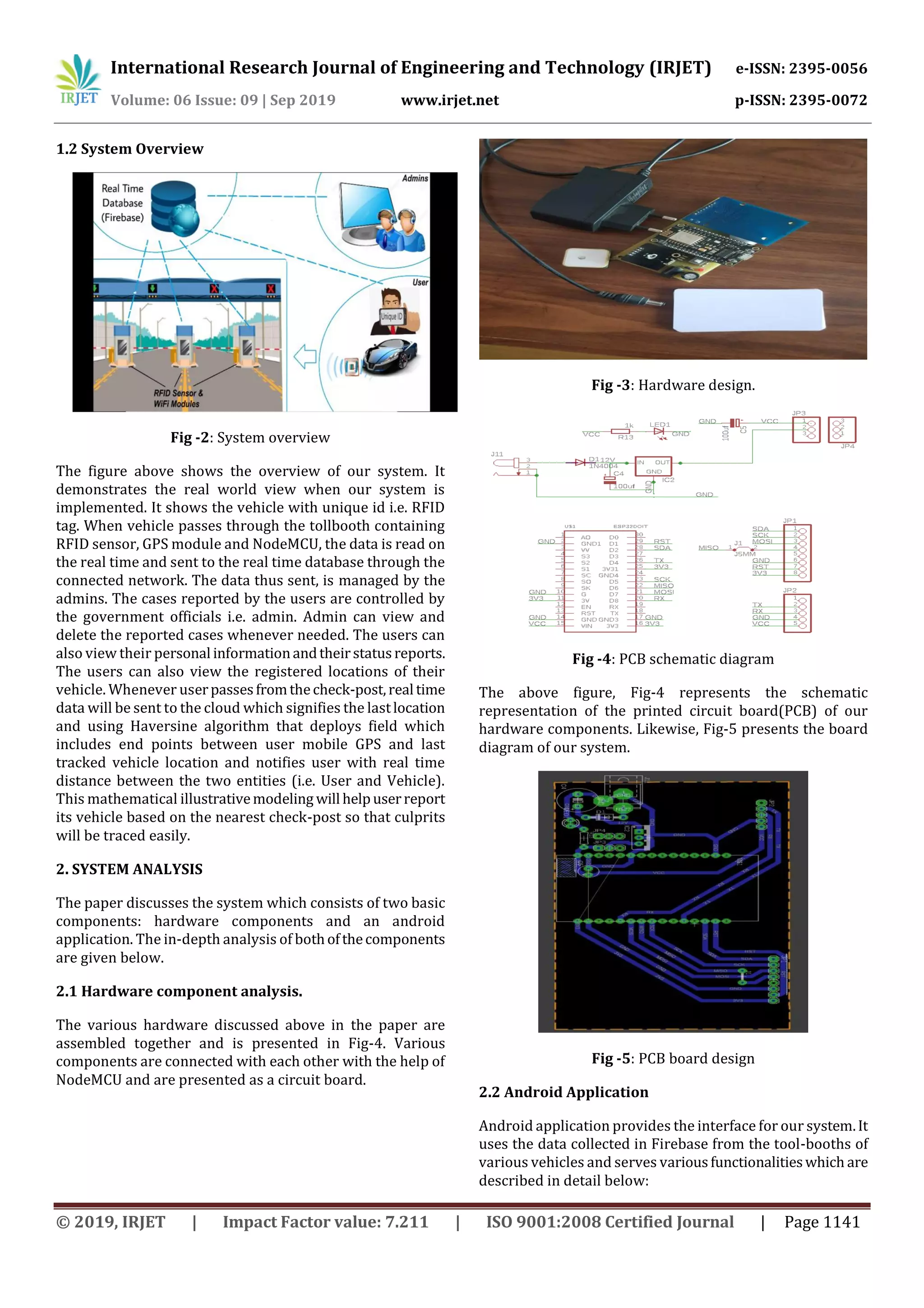
check post location: Kupondole, Kathmandu (Latitude:
27.689922, Longitude: -85.312544)
Let’s compute the distance with the above written
formula. Your answer would be 3.32478Km(kilo-meter).
The snapshot demonstrates the same result with
calculation below:
Fig -8: Distance approximation using Haversine algorithm
2.2.4 Linear Search through modeling for the latest
visited check-post location
The paper depicts the project that started off with the
integration of hardware components i.e. NodeMCU, ESP-
8266 Wi-Fi module, MFRC522 RFID sensorsanddeployingit
with the real time cloud so that the data of GPS and tag could
be transferred to the cloud. Working on hardware
integration; we simultaneously worked on the android
application; as our hardware was able to send data to the
cloud making node for each tag; nowourtask onhand wasto
get the user last location from that node which was created
by our Hardware. So eventually we ended up using some
searching algorithm. Since we were working with
unstructured datasets;sousingsomeadvancealgorithmlike
Interpolation and binary search would make our task more
difficult. So we decided using very basic searchingalgorithm
which is linear search. As per our study; we had certain
realization that working with linear search would be more
difficult while handlingmore data sets;Asthisisgovernment
based project so we nevertheless didn’t expected data of
user to be less than 1 lakh tag ID. So we started making
model for our linear search. We started searching through
bottom node of user on the cloud through the model called
as model searching. We started searching node directly
referred to the current tag so that searching would befaster.
Furthermore, we know that we don’t have any capability to
extend the performance of the hardware as the hardware
has its limited specification; so we tried our best to extend
the capacity our project to handle more user through
software programming. To render layout faster for the user;
we made use of the Fragment instead of Activity and instead
of going through database for everytime;wemadeuseof the
model to store the data temporarily and change it whenever
needed.
A simple approach is to do linear search, i.e.
Start from the leftmost element of arr[] and one by
one compare x with each element of arr[].
If x matches with an element, return the index.
If x doesn’t match with any of elements, return -1.
The time complexity of above algorithm is O(n).
3. CONCLUSIONS
Vehicle monitoring and tracking plays an effective and
significant role in the area of transportation management
system where efficient safety measures and preventing
misuse of vehicles are the main concern. Our system
discusses and helps in detecting vehicles, reportingtheftand
assistance to government officials. Although various
researches have been done in this area and many methods
have been implemented, still there is room for
improvements. With a view to do improvements,oursystem
provides an android application for vehicle data recognition
and tracking using the RFID technology.
In future, the project can be used for large scale by
increasing e capacity of hardware and obviously working
with higher range of GPS.
The paper discusses the system which has broad domain. It
is not only limited to the transportation security. It can be
implemented in the various other sectors using the same
concept. It can be used to for the apartments and companies
to keep the track of the vehicles entering intotheirpremises.
It can be implemented in various service centers to give the
benefits or facilities to their customers. It will make the
society more managed. Likewise, it can also beimplemented
in any organization to keep the track of their vehicles where
the problem of privacy is not affected. It can also be used
more efficiently in shopping centers and for preventing
various other crimes or theft control. It can be implemented
in various other domains.
REFERENCES
[1] “AT Command Is Not Responding on Serial
Monitor.” NodeMCU Uno - AT Command Is Not
Responding on Serial Monitor - NodeMCU Stack
Exchange,
NodeMCU.stackexchange.com/questions/38289/at-
command-is-not-responding-on-serial-monitor.
[2] Lakshminarasimhan, Mahesh. IoT Based Traffic
Management System. Mar. 2016,
www.researchgate.net/publication/310036684_IoT_Bas
ed_Traffic_Management_System.](https://image.slidesharecdn.com/irjet-v6i9172-191210061748/75/IRJET-Vehicle-Monitoring-System-using-Internet-of-Things-4-2048.jpg)
![International Research Journal of Engineering and Technology (IRJET) e-ISSN: 2395-0056
Volume: 06 Issue: 09 | Sep 2019 www.irjet.net p-ISSN: 2395-0072
© 2019, IRJET | Impact Factor value: 7.211 | ISO 9001:2008 Certified Journal | Page 1144
[3] Ding, Bin, et al. “The Research on Blind Navigation
System Based on RFID - IEEE Conference Publication.”
Design and Implementation of Autonomous Vehicle
Valet Parking System - IEEE Conference Publication,
Wiley-IEEE Press, 8 Oct. 2007,
ieeexplore.ieee.org/document/4340289/.
[4] “Haversine Formula.”HaversineFormula -Rosetta Code,
29 Jan. 2016, rosettacode.org/wiki/Haversine_formula.
[5] Spk578. “GeoNet.” Distance on a Sphere: The Haversine
Formula,5Oct.2017,
community.esri.com/groups/coordinate-reference-
systems/blog/2017/10/05/haversine-formula.
[6] Miguelbalboa. “Miguelbalboa/Rfid.”GitHub,5 July2018,
github.com/miguelbalboa/rfid.
[7] Firebase. “Firebase/Firebase-Arduino.” Firebase-
Arduino-Master, 3 Aug. 2018,
github.com/firebase/firebase-arduino.
[8] Mikalhart. “TinyGPS Library” TinyGPS Library for
Getting Location, GitHub, 1 Sept. 2013,
github.com/mikalhart/TinyGPS.
[9] PhilJay.“PhilJay/MPAndroidChart.”MPAndroidChartfor
Android, GitHub, 6 June 2018,
github.com/PhilJay/MPAndroidChart.
[10] “How to Use Google Maps on Your Android App.”Google
Maps SDK for Android, Google,
developers.google.com/maps/documentation/android-
sdk/utility/.
[11] Raahi. “Android Service Tutorial: How to Implement
Service in Android.” SwA, 24 July 2018,
www.survivingwithandroid.com/2014/01/android-
service-tutorial-2.html.
[12] GPS Interfacing with NodeMCU ESP12: Getting Location
Data, circuitdigest.com/microcontroller-
projects/interfacing-gps-with-nodemcu-esp12.
[13] Martins, Ruben, et al. “Improving Linear Search
Algorithms with Model-Based Approaches for MaxSAT
Solving.” Improving Linear Search Algorithms with
Model Based Approaches, 11 Feb. 2015,
www.tandfonline.com/doi/abs/10.1080/0952813X.201
4.993508
[14] “How to Use Material Design in Your Android Apps.”
Material Design in Android, Android Authority, 30 Oct.
2017,www.androidauthority.com/how-to-use-material-
design-in-your-android-apps-809937/](https://image.slidesharecdn.com/irjet-v6i9172-191210061748/75/IRJET-Vehicle-Monitoring-System-using-Internet-of-Things-5-2048.jpg)

The document presents a vehicle monitoring system using Internet of Things technologies. The system uses RFID sensors at toll booths to record vehicle information as vehicles pass through. This information is sent to a cloud database and can be accessed through an Android application. The application allows government officials to view vehicle logs and track reported vehicles. It also provides features for users like viewing their vehicle profile and getting notifications. Distance between locations is calculated using the Haversine algorithm. The system aims to help authorities track illegal vehicles and provide assistance to users.