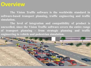
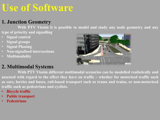
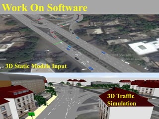
PTV-VISSIM-Traffic
Simulation
Overview
The Vision Traffic software is the worldwide standard in
software-based transport planning, traffic engineering and traffic
simulation.
The level of integration and compatibility of product is
unexcelled, since the Vision Traffic software covers the entire range
of transport planning - from strategic planning and traffic
engineering to vehicle and pedestrian simulation.
Use of Software
1. Junction Geometry
With PTV Vissim it is possible to model and study any node geometry and any
type of priority and signalling.
• Signal control
• Signal groups
• Signal Phasing
• Non-signalised intersections
• Multimodality
2. Multimodal Systems
With PTV Vissim different multimodal scenarios can be modelled realistically and
assessed with regard to the effect they have on traffic – whether for motorised traffic such
as cars, lorries and buses, rail-based transport such as trams and trains, or non-motorised
traffic such as pedestrians and cyclists.
• Bicycle traffic
• Public transport
• Pedestrians
3. Multimodal Systems
With PTV Vissim different multimodal scenarios can be modelled realistically and
assessed with regard to the effect they have on traffic – whether for motorised traffic such
as cars, lorries and buses, rail-based transport such as trams and trains, or non-motorised
traffic such as pedestrians and cyclists.
• Bicycle traffic
• Public transport
• Pedestrians
4. Motorway Traffic
With PTV Vissim achieves realistic results at this aggregated level by means of
detailed geometry and microscopic behaviour models.
• Operational level: Driving behaviour
• Tactical level: Lane selection and cooperative behaviour
5. Public Transport
With PTV Vissim aids traffic engineers in different sub-disciplines of public
transport planning and offers them an extensive range of dedicated features and detailed
modelling possibilities.
• Public transport partial route diversion
• Public transport priority
Benefits of Software
1. Multimodality
Dedicated motion models for motorised traffic, bicycles and pedestrians make a
valid assessment and a realistic representation of all traffic-related aspects possible.
2. Maximum accuracy
links and connectors concept, you can map your network in detail and model
different geometries – from a standard node to complex intersections.
3. Virtual testing of autonomous vehicles
The capability of the software to model all modes of transport and their
interactions integrated in a single tool allows users not only to test the dynamics of
automated vehicles but also to convey a valid assessment of all traffic-related aspects.
4. Ease-of-use & productivity
The graphical user interface with 2D and 3D network windows, editors with many
features for efficiently creating and editing network objects and their attributes, as well as
numerous options for outputting results, all ensure ideal user-friendliness.
Data Required
• Lanes on the road
• Types of Vehicle ply on the road
• NMT Infrastructure, if applicable
• Public transport lane, if applicable
• Parking Lots / Survey
• Vehicular Count (CVC and TMC)
• Signal Phases
• Signal timings
• Spot Speed study
• Travel time and Delay Study
Work On Software
Link and Connector Concept of PTV VISSIM
2D Traffic Simulation
Work On Software
3D Static Models Input
3D Traffic
Simulation
Introduction of vissim software

Introduction of vissim software

  • 1.
  • 2.
    Overview The Vision Trafficsoftware is the worldwide standard in software-based transport planning, traffic engineering and traffic simulation. The level of integration and compatibility of product is unexcelled, since the Vision Traffic software covers the entire range of transport planning - from strategic planning and traffic engineering to vehicle and pedestrian simulation.
  • 3.
    Use of Software 1.Junction Geometry With PTV Vissim it is possible to model and study any node geometry and any type of priority and signalling. • Signal control • Signal groups • Signal Phasing • Non-signalised intersections • Multimodality 2. Multimodal Systems With PTV Vissim different multimodal scenarios can be modelled realistically and assessed with regard to the effect they have on traffic – whether for motorised traffic such as cars, lorries and buses, rail-based transport such as trams and trains, or non-motorised traffic such as pedestrians and cyclists. • Bicycle traffic • Public transport • Pedestrians
  • 4.
    3. Multimodal Systems WithPTV Vissim different multimodal scenarios can be modelled realistically and assessed with regard to the effect they have on traffic – whether for motorised traffic such as cars, lorries and buses, rail-based transport such as trams and trains, or non-motorised traffic such as pedestrians and cyclists. • Bicycle traffic • Public transport • Pedestrians 4. Motorway Traffic With PTV Vissim achieves realistic results at this aggregated level by means of detailed geometry and microscopic behaviour models. • Operational level: Driving behaviour • Tactical level: Lane selection and cooperative behaviour 5. Public Transport With PTV Vissim aids traffic engineers in different sub-disciplines of public transport planning and offers them an extensive range of dedicated features and detailed modelling possibilities. • Public transport partial route diversion • Public transport priority
  • 5.
    Benefits of Software 1.Multimodality Dedicated motion models for motorised traffic, bicycles and pedestrians make a valid assessment and a realistic representation of all traffic-related aspects possible. 2. Maximum accuracy links and connectors concept, you can map your network in detail and model different geometries – from a standard node to complex intersections. 3. Virtual testing of autonomous vehicles The capability of the software to model all modes of transport and their interactions integrated in a single tool allows users not only to test the dynamics of automated vehicles but also to convey a valid assessment of all traffic-related aspects. 4. Ease-of-use & productivity The graphical user interface with 2D and 3D network windows, editors with many features for efficiently creating and editing network objects and their attributes, as well as numerous options for outputting results, all ensure ideal user-friendliness.
  • 6.
    Data Required • Laneson the road • Types of Vehicle ply on the road • NMT Infrastructure, if applicable • Public transport lane, if applicable • Parking Lots / Survey • Vehicular Count (CVC and TMC) • Signal Phases • Signal timings • Spot Speed study • Travel time and Delay Study
  • 7.
    Work On Software Linkand Connector Concept of PTV VISSIM 2D Traffic Simulation
  • 8.
    Work On Software 3DStatic Models Input 3D Traffic Simulation