Info s4 summary
•
0 likes•492 views

S4 is a georeferenced software that integrates data from combines, satellite images, and other sources to allow farmers to plan, operate, analyze, and audit agricultural production from individual, organizational, and benchmarking perspectives. It facilitates efficiency gains, certification compliance, traceability, and investment auditing for farmers and third parties. S4 is accessible via web and currently has projects in Argentina, Uruguay, Colombia, Ghana, Ukraine, Chile, Paraguay, and Bolivia, covering crops like soybean, corn, sunflower, and wheat.
Recommended

More Related Content
What's hot
What's hot (20)
Viewers also liked
Viewers also liked (14)
Similar to Info s4 summary
Similar to Info s4 summary (20)
Recently uploaded
Recently uploaded (20)
Info s4 summary
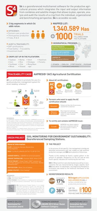
- 1. S4 is a georeferenced multichannel software for the productive agricultural process which integrates the input and output information from combines and satellite images that allows to plan, operate, analyze and audit the results of a crop from the individual, organizational and benchmarking perspective. S4 is accesible via web. MAPPED LOT: 2 big segments in which S4 adds value: 1.340.589 Has EFFICIENCY: • Farmers own production • Third-parties production • Trials, R & D 1000 FOLLOWED FROM THE PLATFORM. GEOGRAPHICAL PRESENCE: AUDIT & TRACEABILITY: • GAP certifications • Food Safety – Traceability • Investment Audit ACTIVE PROJECTS: Argentine, Uruguay & Colombia PROJECTS WITH MAPPED FIELDS: Ghana & Ukraine CROPS SET UP IN THE PLATAFORM: • Soybean • Corn • Sunflower • Wheat TRIALS • Barley • Vetch • Hazelnuts • Rice • Chickpea • Forestry • Chía • Mung Bean • Oilseed rape LANDING IN: Chile, Paraguay & Bolivia SPANISH ENGLISH PORTUGUESE RUSSIAN AVAILABLE LANGUAGES TRACEABILITY CASE AAPRESID(1) (AC) Agricultural Certification AC is a certification to promote the use of a quality production management system for direct seeding schemes(2). About AC certification: GAP AMI Benefits and Opportunities Agronomic management indicators Farmers who want to apply the AC certification should: MACHINERY FARMER B+O Good Agricultural Practices SOIL TESTING LABORATORY ASSOCIATION (CERTIFIES) Document Measure & record AC CERTIFICATION SUSTAINABILITY S4 ALLOWS TO FOLLOW AGRONOMIC MANAGEMENT INDICATORS GLOBAL MARKETS REFERENCES (1) AAPRESID: Argentine Farmer Association. AAPRESID promotes the No Till system in order to achieve an economically, environmentally and socially sustainable agricultural activity based on technological, organizational and institutional innovation, undertaking the commitment to interact with public and private organizations to achieve an integral development of Argentina. (2) Direct seeding: is a cropping system which aims to improve soil and soil moisture conservation. Soil is not tilled before planting. Analyze and describe the processes involved their production. Must implement and keep systematic records that allows auditor to make a detailed evaluation. S4 INTEGRATES STANDARIZED INFORMATION To certify and validate AAPRESID must: To audit AAPRESID must obtain evidence and assess compliance with the AC protocol plans in order to issue Certificate. S4 MAKES AVAILABLE THE INFORMATION. GREEN PROJECT SOIL MONITORING FOR ENVIRONMENT SUSTAINABILITY: Georeferenced Sampling Stations. THE PROJECT General Information PLACE > Henderson, Daireaux, Buenos Aires. Pampa Argentina In the process of site specific crop management strategy we delimited environments with low, middle an high potential production averages and GSS were placed on those areas. AVERAGE RAINFALL > 800/900 mm annual precipitation AVERAGE TEMPERATURE > Summer 20/25º; Winter 5º/10º TYPE OF PROJECT > Green Project / SOM (2) evolution and assimilable phosphorous environment relationships. Method: Followed by GSS (1) CROP ROTATION > Wheat, Corn & Soybean SOWING STRATEGY > Direct Seeding(3) REFERENCES (1) GSS = Georreferenced Sample Stations (2) SOM = Soil Organic Matter (3) Direct Seeding = Direct seeding is a cropping system which aims to improve soil and soil moisture conservation. Soil is not tilled before plating. GSS: Georeferenced Sample Stations .It is a sample point which represents an specific area. GSS logic: We choose a point in the lot. This point should define the productive capabilities of the agroecological area.. Once we choose that point, an automate area of 1 hectare around will be defined on the platform. In this areas is where we are going to take soil samples. BANCO GALICIA Nominated for innovation award Thanks to this method we found a spatial pattern in the amount of available. Phosporous on the soil and we also found specific indicators for monitoring the over time. GSS In Wheat and Corn were distributed every 60 has in environments that are characterized by images satellite. Each GSS took about 15 subsamples. Soy diagnosing Phosphorus fertilization was based on the historical information of the environment. GEOREFERENCED RESULTS SOM increased in Nitrogen APPLICATION 4 YEARS surface considered as low productivity environments. 17% increased in 38% 4 YEARS TERNIUM SIDERAR AWARD 2013 Silver Medal Software Category WAS AVOIDED IN 30% of UP TO SAVINGS 100 U$D FIELD > La Paz & La Mancha, 36° 36’ 0” S, 60° 45’ 0” W PER HECTARE IN CORN SEED AGROFUTURO 2013 Innovation Service Award mention