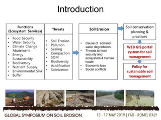
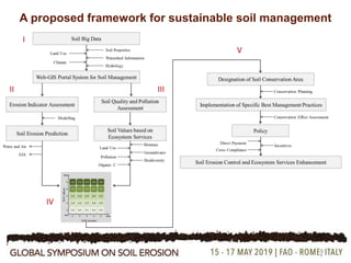
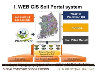
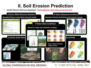
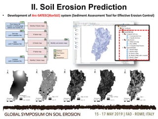
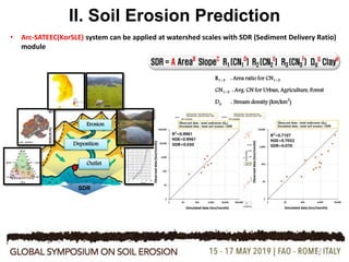
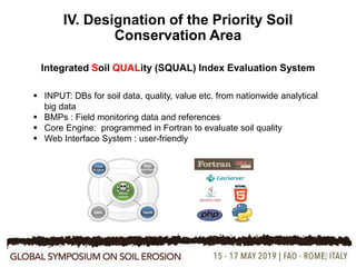
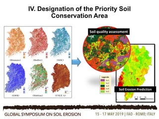
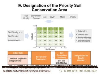
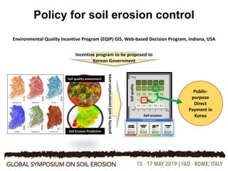
2. Acknowledgements
Grants by Rural Development Administration (RDA)
and Ministry of Environment (MoE), Korea
Research Groups by SSORii and EcoSSSoil
2
3. 3
Introduction
Soil Erosion
• Cause of soil and
water degradation
• Threats to food
security and
ecosystem & human
health
• Economic loss
• Social conflicts
Soil conservation
planning &
practices
WEB GIS portal
system for soil
management
Policy for
sustainable soil
management
4. 4
Objective
To propose a decision supporting framework for the
planning, assessment, and policy of soil and water
conservation, by integrating both soil erosion and
ecosystem services
5. 5
Soil Erosion Prediction: Models
(Karydas et al., 2014)
Empirical models: on-site field scale assessment of soil loss:
•USLE
•RUSLE
•MUSLE
•KORSLE
•CSLE etc.
Process-based models: field- to watershed scale assessment of
management practice effects on both on-site and off-site concerns
•Agricultural Policy/Environmental eXtender (APEX)
•Annualized Agricultural Non-Point Source (AnnAGNPS)
•European Soil Erosion Model (EUROSEM)
•Kinematic Runoff and Erosion Model (KINEROS2)
•Limburg Soil Erosion Model (LISEM)
•Rangeland Hydrology and Erosion Model (RHEM)
•Soil and Water Assessment Tool (SWAT)
•Water Erosion Prediction Project (WEPP)
•Wind Erosion Prediction system (WEPS) etc.
6. 6
Soil Erosion Modelling
• Application of soil erosion models:
Conservation planning and assessment
Sediment source identification
Assessment of management options
Dynamic hydrologic and erosion assessment
• Selection of erosion model for conservation assessment and
planning
Function of modeling purposes
Characteristics of the natural system under study
Data availability (Wagner et al., 2001)(Ascough et al., 2018)
• Simulate “what-if” scenarios at varying spatial and
temporal scales
7. 7
Soil Erosion Modelling
confined to the assessment of the amount of soil erosion and practice
effect
not further linked to policy for implementation of sustainable soil
management
Ascough et al. (2018) Limitations:
• Site-specific
• Lack of credibility
• Insufficient data
• Difficulty in model parameter determination
• Absence of widely accepted modeling algorithms etc.
9. 9
I. WEB GIS Soil Portal system
Soil Value
Assessment Manual
Erosion Type/Cost
Economical Soil
Management
Soil Erosion Prediction
System
Web-GIS Soil
Management System
10. 10
II. Soil Erosion Prediction
• KorSLE (Korean Soil Loss Equation) – Technology for input data processing tool
R factor (Web ERosivity Module)
Monthly R factors using 10min interval rainfall
http://www.envsys.co.kr/~werm
K factor (Seasonal variation)
Monthly K factors (soil texture and organic matter)
LS factor (main flow direction) C factor (Time-variant)
Computing Slope length based on topography
Date (Month)
1 2 3 4 5 6 7 8 9 10 11 12
USLEKfactor
0.078660
0.078665
0.078670
0.078675
0.078680
0.078685
Af
Monthly C factors
8 flow
directions
P factor (Real-condition)
Based on slope and cultivation method
(Crop, Support Practice,
Tillage system)
Slope/
Slope-length
11. 11
• Development of Arc-SATEEC(KorSLE) system (Sediment Assessment Tool for Effective Erosion Control)
II. Soil Erosion Prediction
12. 12
II. Soil Erosion Prediction
• Arc-SATEEC(KorSLE) system can be applied at watershed scales with SDR (Sediment Delivery Ratio)
module
Outlet
Deposition
Erosion
SDR
R1~3 : Area ratio for CN1~3
CN1~3 : Avg. CN for Urban, Agriculture, Forest
Dd : Stream density (km/km
2
)
13. 13
II. Soil Erosion Prediction
Watershed Information
Watershed AnalysisSoil Erosion at Watershed
Level
Jan. Feb. Mar. Apr. May Jun. Jul. Aug. Sep. Oct. Nov. Dec.
KORSLE A
● Annual Average
■ Monthly Average
14. 14
III. Soil Quality and Ecosystem Services
Soil Quality Index
Soil services/function Value (million $)
Biomass production 13,838
Nutrient 987,159
Water resource 20,195
Carbon storage 16,236
Waste treatments 69,594
Biodiversity pool 2,131
15. 15
IV. Designation of the Priority Soil
Conservation Area
Integrated Soil QUALity (SQUAL) Index Evaluation System
INPUT: DBs for soil data, quality, value etc. from nationwide analytical
big data
BMPs : Field monitoring data and references
Core Engine: programmed in Fortran to evaluate soil quality
Web Interface System : user-friendly
16. 16
IV. Designation of the Priority Soil
Conservation Area
Soil quality assessment
Soil Erosion Prediction
17. 17
IV. Designation of the Priority Soil
Conservation Area
D/B Maps Policy
Education
Awareness
BMP
Soil Quality and
Soil Erosion
Assessments
Ecosystem
Service
Soil
Quality
Policy Making
Stakeholders
Index Data
→
Soil Quality
Parameters
→
Soil
Ecosystem
Function →
Integrated Soil
Quality
(SQUAL)
Chemical, physical &
biological data Soil loss
(KORSLE A)
19. 19
Single-Plot
Multi-Plots
Soil Function Click
Click
Soil Erosion
Safe Area
Soil Erosion
Concerned Area
Current Grade
Improve Grade
Soil Erosion
Concerned Area
BMP Click
Soil Erosion
Concerned Area
BMP Suggestion
V. Soil Conservation Planning and Assessment
20. 20
Forest -> Agricultural Field : Change Land Use
• Groundwater: 0.844 0.831 (Normalized Value)
• Erosion: 30.65ton/ha/yr 31.74 ton/ha/yr
Click the Land Use Change
Current Land Use: Forest
Forest
Agricultural Field
V. Soil Conservation Planning and Assessment
22. 22
Policy for Soil Erosion and ES
Goals for
Sustainable
Soil
Management
1. Minimize soil threats
(Erosion Control)
2. Enhance soil
ecosystem services
3. Policy for a holistic
management
If soil erosion and population growth remain unconstrained from their current rates, humankind may lose the
ability to feed itself (Ascough II et al., 2018).
23. Discussion: Lessons from case
studies
23
1. Enormous economic loss from soil erosion
2. High cost of BMP Implementation and its low efficiency
3. Regional conflicts for drinking water resources etc.
4. Integrated technical, institutional and policy options
5. Useful background information and a scientific framework to enhance
collaborative management and more investment for sustainable
development
Holistic system for soil management!
24. 24
Policy for soil erosion control
Implementation
Structural BMP Policy
Ministries &
Organizations
Total
(US$ million)
13 projects 10 projects 10 386
Proposal
Management options (10 yrs) with <50 NTU
BMP Buyout
Forest
restoration
Total
US$ 680 US$ 105 US$ 104 US$ 935 M
25. 25
Policy to Reduce Soil Erosion in Korea
Rearrangement of upland structure
Eco-friendly road construction and forest clearance
Cover crop and green manure
River basin rearrangement and maintenance
Reservoirs in erosion vulnerable areas
Structural BMP implementations
NPS control and monitoring with BMP and riparian management
Soil erosion assessment and technology
Check dam installments
Reduction of top dressing soil collection and application
Education, outreach and awareness programs
Council for diverse stakeholders
Development of top soil management system
Cropping systems and practices: diversification
Water quality maintenance goal
Direct payment and buyout for erosion sensitive lands etc.
No obligation for farmers or landowners
No integrated efforts among science, technology, policy, culture, economy etc.
No single government ministry in charge of soil erosion control
Not enough budget
26. 26
Policy for soil erosion control
policy
Direct
Payment
Incentive
Cross
Compliance
Soil and
Water
Indicators
Soil Values
Holistic
27. 27
Policy for soil erosion control
Soil erosion
Soilquality
Environmental Quality Incentive Program (EQIP) GIS, Web-based Decision Program, Indiana, USA
Soil Erosion Prediction
Soil quality assessment
priorityinsoilconservationarea
Public-
purpose
Direct
Payment in
Korea
Incentive program to be proposed to
Korean Government
28. Discussion
28
The web-based portal system provides up-to-date, ease-of-use
interface for decision makers/stakeholders/researchers
BMP`s selection process is simple, but it will be helpful as a
screening tool to identify AOC (Area Of Concern).
Needs more database on BMP, ecosystem services, quality and soil
properties
SQUAL system is just an example protocol to develop the
management system
A lot more of interactive works needed and continued
29. 29
Summary
1. A proposed framework can be modified for different
countries having different spatio-temporal scales, and it can
depend on data availability.
2. Further long-term validation is definitely needed to improve
the credibility of the framework for use by farmers or policy
makers.
3. However, the proposed framework provides a protocol
useful for holistic planning of soil and water conservation
and policy implementation.